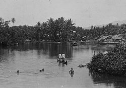
The Bacan Islands, formerly also known as the Bachans, Bachians, and Batchians, are a group of islands in the Moluccas in Indonesia. They are mountainous and forested, lying south of Ternate and southwest of Halmahera. The islands are administered by the South Halmahera Regency of North Maluku Province. They formerly constituted the Sultanate of Bacan.

Pasuruan is a city in East Java Province of Java, Indonesia. It had a population of 186,262 at the 2010 Census and 208,006 at the 2020 Census; the official estimate as at mid 2023 was 212,466.

Mojokerto is a city in East Java Province of Indonesia. It is located 40 km southwest of Surabaya, the provincial capital, and constitutes one of the component units of the Surabaya metropolitan area which comprises Gresik Regency, Bangkalan Regency, Mojokerto Regency, Mojokerto City, Surabaya City, Sidoarjo Regency, and Lamongan Regency. The city covers an area of 20.21 km2, and had a population of 120,196 at the 2010 census and 132,434 at the 2020 Census; the official estimate as of mid-2023 was 141,785.

Maumere is the administrative seat of the Sikka Regency and the second largest town on Flores Island, Indonesia. It lies on the north coast of the island and the port is in the north-west part of the town. Administratively the town is not a single district (kecamatan) within the regency, but is divided into three districts – Alok Barat, Alok and Alok Timur – although the latter two districts also include a number of substantial islands off the north coast of Flores.

Pamekasan Regency is a regency (kabupaten) of the province of East Java, Indonesia. It is located on Madura Island approximately 120 kilometres (75 mi) east of Surabaya, the provincial capital. The regency covers an area of 792.30 square kilometres (305.91 sq mi), and at the 2010 census it had a population of 795,918 ; at the 2020 census the total was 850,057 and the official estimate as of mid-2023 was 882,837 – comprising 431,891 males and 450,946 females. The administrative capital is the town of Pamekasan.

Pelalawan is a regency (kabupaten) of Riau Province, Indonesia. It is located on the island of Sumatra. The regency was created on 4 October 1999 as a result of the division of Kampar Regency, of which it was previously the eastern 43%. It now has an area of 13,408.72 km2 and had a population of 301,829 at the 2010 Census and 390,046 at the 2020 Census; the official estimate as at mid 2023 was 415,469. The administrative centre is in the town of Pangkalan Kerinci.

Tanjungbalai, also colloquially written as Tanjung Balai, is a city in North Sumatra province, Indonesia, on the estuary of the Asahan River. It has an area of 60.52 square kilometers (23.37 sq mi) and the sixth largest kota (urban) population in North Sumatra with 154,445 inhabitants in the 2010 census and 176,027 at the 2020 Census; the official estimate as at mid 2023 was 183,170 - comprising 92,715 males and 90,455 females. The town has a ferry terminal with services to Port Klang, Malaysia, and the city-island of Singapore.

Lubuklinggau, is a city in South Sumatra, Indonesia. It has an area of 401.50 km2 and had a population of 201,308 at the 2010 Census and 234,166 at the 2020 Census; the official estimate as at mid 2023 was 241,894. The city was formerly part of the Musi Rawas Regency from which it was separated on 21 June 2001.

Martapura is the capital of the Banjar Regency in South Kalimantan province, Indonesia. It is located close to the city of Banjarbaru and it consists of three districts within the Regency - Martapura, West Martapura and East Martapura, with a combined population at the 2020 Census of 169,356 people; the official estimate as at mid 2023 was 174,876.

Balangan Regency is one of the regencies in the Indonesian province of South Kalimantan. It was created on 25 February 2003 from what were previously the eastern districts of North Hulu Sungai Regency. It now covers an area of 1,828.51 km2, and had a population of 112,430 at the 2010 Census and 130,355 at the 2020 Census; the official estimate as of mid-2023 was 136,520, consisting of 69,150 males and 67,380 females. The capital is the town of Paringin. the regency's motto is "Sanggam" (Banjarese), also an acronym for "Sanggup Bagawi Gasan Masyarakat".

Barito Kuala Regency is one of the regencies (kabupaten) in the Indonesian province of South Kalimantan. It is situated in the southwest of the province, bordering Central Kalimantan province to its immediate west and separated from Banjarmasin city to its east by the lower reaches of the Barito River. The regency's land area is 2,996.46 km2, and the population was 276,147 at the 2010 Census and 313,021 at the 2020 Census; the official estimate was 324,502. The capital is the town of Marabahan. The Motto of the Regency is "Selidah".

Serang is a city and the capital of Banten province and was formerly also the administrative center of Serang Regency in Indonesia. The city is located towards the north of Banten province, on the island of Java; the north part of the city contains the coast zone facing onto Banten Bay, and includes the historical site of Old Banten, after which the province is named. Before Banten province was formed in 2000, Serang city was part of West Java province.
Kota Jantho is a small town in Aceh province of Indonesia. Jantho is the seat of local government for the Aceh Besar Regency. It covers an area of 592.5 km2 and had a population of 8,443 at the 2010 Census and 9,440 at the 2020 Census.
Bireuën or Bireun is an Indonesian town, the seat of the Bireuën Regency government in the Aceh Special Territory of Sumatra. Bireuen is located at 5°12′18″N96°42′06″E. The town covers an area of 16.91 km2, and it had a population of 44,604 at the 2010 Census and 47,670 at the 2020 Census; the official estimate as at mid 2022 was 47,983.
Kefamenanu is a town and capital of the administrative district (kecamatan) of Kota Kefamenanu and of the North Central Timor Regency in West Timor, Indonesia. A road connects it to Halilulik and Kota Atambua to the northeast. It had a population of 43,058 at the 2010 Census and 47,766 at the 2020 Census; the official estimate in mid 2023 was 49,589. The town hosts the University of Timor, one of the two public universities in the Indonesian part of the island.
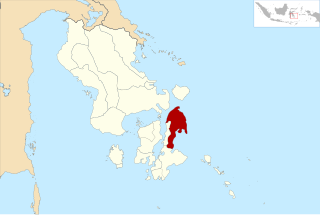
South Halmahera Regency is a regency of North Maluku Province, Indonesia. It lies partly on Halmahera Island and partly on smaller islands to the west and south of Halmahera. It covers a land area of 8,779.32 km2, and at the 2010 Census it had a population of 198,911 people, while the 2020 Census showed that this had risen to 248,395 and the official estimate in mid 2023 was 255,384 The capital lies at the town of Labuha on Bacan Island.

East Halmahera Regency is a regency of North Maluku Province of Indonesia, and occupies the northeastern peninsula of Halmahera island, together with the northern half of the southeastern peninsula of that island. It was created on 25 February 2003 from part of Central Halmahera Regency, and covers a land area of 6,515.74 km2. It had a population of 72,880 at the 2010 Census and 91,707 at the 2020 Census; the official estimate as at mid 2023 was 97,895. The capital lies at the town of Maba in Kota Maba District.

Paser Regency is the southernmost regency (kabupaten) within the East Kalimantan province of Indonesia. It was created in 1959, originally spelt "Pasir Regency", but renamed "Paser" in 2007; however its northeastern districts were split off on 10 April 2002 to form the new Penajam North Paser Regency. The residual regency covers an area of 11,603.94 km2, and it had a population of 230,316 at the 2010 Census and 275,452 at the 2020 Census; the official estimate as at mid-2023 was 303,424. Its administrative centre is the town of Tana Paser.
North Buton Regency is a regency of Indonesia's Southeast Sulawesi Province, which was separated from Buton Regency in accordance with Indonesia's Law Number 14 of 2007. The area of the regency, which covers the north part of Buton Island, is 1,923.03 km2. Its population was 54,736 at the 2010 Census and 66,653 at the 2020 Census; the official estimate as at mid 2023 was 72,757. The administrative capital of the regency is at the town of Buranga, in Bonegunu District.

Kotamobagu is a city in North Sulawesi, Indonesia. Having previously been a town within the Bolaang Mongondow Regency, Kotamobagu was separated from that regency on 2 January 2007 to become an autonomous city. It is the principal centre of the southern part of the province, the Bolaang Mongondow region, which has been under consideration by the Indonesian government to be separated from the rest of North Sulawesi and formed into a separate province. The city covers an area of 108.89 km2, and had a population of 107,459 at the 2010 Census, rising to 123,722 at the 2020 Census; the official estimate as at mid 2023 was 123,918.