
North Jakarta is one of the five administrative cities which form Special Capital Region of Jakarta, Indonesia. North Jakarta is not self-governed and does not have a city council, hence it is not classified as a proper municipality. It contains the entire coastal area within the Jakarta Special Capital Region. North Jakarta, along with South Jakarta is the only two cities in Jakarta to border Banten and West Java. It is also the only two cities and regencies of Jakarta with a coastline and not landlocked along with the Thousand Islands Regency. North Jakarta, an area at the estuary of Ciliwung river was the main port for the kingdom of Tarumanegara, which later grew to become Jakarta. Many historic sites and artefacts of Jakarta can be found in North Jakarta. Both ports of Tanjung Priok and historic Sunda Kelapa are located in the city. The city, which covers an area of 139.99 km2, had 1,645,659 inhabitants at the 2010 census and 1,778,981 at the 2020 census; the official estimate as at mid 2022 was 1,793,550 - comprising 905,575 males and 887,975 females. It has its administrative centre in Tanjung Priok.

Tangerang Regency is a regency of Banten Province, Indonesia. It is located in the northwest of the island of Java. The current regent is Ahmed Zaki Iskandar. Though commonly misunderstood as being a part of Jakarta, Tangerang is actually outside Jakarta City but is part of Greater Jakarta. Since 1993, the regency has lost territory as first Tangerang city was split off on 27 February 1993 and subsequently South Tangerang city was split off on 29 October 2008. The residual Regency now has an area of 1,034.54 km2 and a population of 2,834,376 at the 2010 census, growing to 3,245,619 at the 2020 census; the latest official estimate is 3,309,365, reflecting a recent slowing down in the rate of population growth since 2020. The town of Tigaraksa is the regency seat.
Pagar Alam, is a city in South Sumatra, Indonesia. It was formerly part of Lahat Regency, from which it was separated as an independent city on 21 June 2001; before being established as an independent city, Pagar Alam was an administrative city within Lahat Regency. It has an area of 633.66 km2 and a population of 126,181 at the 2010 Census and 143,844 at the 2020 Census; the official estimate as at mid 2022 was 147,071.

Tabalong Regency is the most northerly of the regencies in the Indonesian province of South Kalimantan, on Borneo Island. It was created on 14 July 1965 by splitting off the former northern districts of North Hulu Sungai Regency. It has a land area of 3,553.36 km2, and had a population at the 2010 Census of 218,620 and 253,305 at the 2020 Census; the official estimate as of mid-2023 was 262,631. The administrative capital is the town of Tanjung. The Regency's motto is "Saraba Kawa".

Kutai Kartanegara Regency is a regency of East Kalimantan Province, Indonesia. It has a land area of 27,263.10 km2 and a water area of 4,097 km2, geographically located between 1°18′40″S and 116°31′36″E. The population of the regency was 626,286 at the 2010 Census and 729,382 at the 2020 Census; the official estimate as of mid-2023 was 788,113. The town of Tenggarong is the capital of the regency.
North Labuhanbatu Regency is a regency of North Sumatra, Indonesia, created on 21 July 2008 by being carved out of the north-western districts of the existing Labuhanbatu Regency, which until 2008 covered an area of 9,703 square kilometres and had a population of 840,382 according to the 2000 census. 60.99% of the regency is forested. The new North Labuhanbatu Regency covers 3,545.8 square kilometres and had a population of 331,660 at the 2010 Census, rising to 381,994 at the 2020 Census; the official estimate as at mid 2023 was 401,863 . The Kualuh River is located in this regency. The administrative centre of the regency is at the town of Aek Kanopan.

Seluma Regency is a regency of Bengkulu Province, Indonesia, on the west coast of the island of Sumatra. It was created on 25 February 2003 from what were formerly the northwestern districts of the South Bengkulu Regency. The regency seat is at the town of Pasar Tais. It covers an area of 2,479.36 km2, and had a population of 173,507 at the 2010 Census and 207,877 at the 2020 Census; the official estimate as at mid 2022 was 213,755.

Banyuasin is a regency of South Sumatra Province in Indonesia. The Regency was formed on 10 April 2002 from the coastal and eastern areas formerly part of the Musi Banyuasin Regency. It takes its name from the main river which drains that area, the Banyuasin River. Pangkalan Balai is the regency seat. The regency borders Musi Banyuasin Regency, Jambi province and Bangka Strait to the north, Bangka Strait to the east, Ogan Komering Ilir Regency, Muara Enim Regency, and the city of Palembang to the south, and Musi Banyuasin Regency to the west. It has an area of 12,551.15 km2 and had a population of 749,107 at the 2010 census and 836,914 at the 2020 census; the official estimate as at mid 2023 was 850,022. Much of the regency is coastal lowland.

Empat Lawang Regency is a regency of South Sumatra Province, Indonesia. It was created on 2 January 2007 from what had been formerly the western districts of Lahat Regency. It covers an area of 2,256.44 km² and had a population of 221,176 at the 2010 Census and 333,622 at the 2020 Census; the official estimate as at mid 2022 was 357,673. The regency seat is at the town of Tebing Tinggi.

Muara Enim Regency is a regency of South Sumatra Province, Indonesia. The regency seat is the town of Muara Enim. The city of Prabumulih is an administrative body separating the main part of Muara Enim to the south of the city from a smaller part to its north. The regency until late 2012 covered an area of 8,587.94 km² and had a population of 717,717 at the 2010 Census; however, on 14 December 2012 five districts from the Muara Enim Regency were split off to form the new Penukal Abab Lematang Ilir Regency.

Ogan Ilir Regency is a regency of South Sumatra Province, Indonesia. It takes its name from the main river which stream that area, Ogan River. And the name Ilir means downstream. Indralaya is the regency seat. The regency borders Palembang City and Muara Enim Regency to the north, Ogan Komering Ilir Regency to the east, Ogan Komering Ilir Regency, and East Ogan Komering Ulu Regency to the south, and Muara Enim Regency to the west.

Ogan Komering Ulu Regency is a regency of South Sumatra, Indonesia. It formerly covered an area of 10,408 km2 with a population of around 1,000,000 people; however on 18 December 2003 parts of this area were split off to form separate regencies of East Ogan Komering Ulu and South Ogan Komering Ulu; the residual regency area covers just 4,797.06 km2 and had a population of 324,045 at the 2010 Census and 367,603 at the 2020 Census; the official estimate as at mid 2023 was 383,608. The administrative centre is the town of Baturaja.

North Lampung Regency is an inland regency (kabupaten) of Lampung Province, Sumatra, in Indonesia. As originally created, it covered a much larger share of the land area of Lampung Province, but on 16 August 1991 its western districts were split off to create a new West Lampung Regency ; on 3 January 1997 its north-eastern districts were split off to create a new Tulang Bawang Regency ; and on 20 April 1999 its north-western districts were split off to create a new Way Kanan Regency.

Tanggamus Regency is a regency (kabupaten) of Lampung Province, Sumatra, Indonesia. It has an area of 4,654.96 km2 which consists of a land area of 2,855.46 km2 and a sea area of 1,799.5 km2. It had a population of 534,595 at the 2010 Census and 640,275 at the 2020 Census; the official estimate as at mid 2023 was 662,542. The regency seat is the town of Kota Agung Pusat. The regency was created on 21 March 1997 from what were previously the western districts of South Lampung Regency, but districts in its eastern part split away on 29 October 2008 to form the new Pringsewu Regency. It lies in the southwest of the province, and surrounds Semangka Bay on its west, north and east coasts.

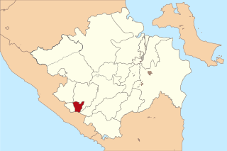
Pesisir Barat Regency is a regency in Lampung Province of Indonesia. It was created on 25 October 2012 from the eight western districts of West Lampung Regency. It covers an area of 2,907.23 km2, and had a population of 141,741 at the 2010 Census and 162,697 at the 2020 Census; the official estimate as of mid-2023 was 174,695. The administrative center is the town of Krui. The majority group in the Pesisir Barat Regency is the Lampung people, while the Bengkulu language is also spoken in some districts.

Penukal Abab Lematang Ilir Regency is a regency of South Sumatra Province, Indonesia. It takes its name from the three main rivers which flow through that area - the Penukal River, Abab River and Lematang River - while the name Ilir means "downstream". The town of Talang Ubi is the administrative centre of this regency. The regency borders Musi Banyuasin Regency to the north, Banyuasin Regency, and Muara Enim Regency to the east and the south, and by Musi Rawas Regency, and Muara Enim Regency to the west.


