With the completion of the first road into the mountains in this region, Lake City served as a supply center for the many miners and prospectors flooding into the area. As a supply center, the town boomed to as many as 3,000 to 5,000 settlers. But as the first-discovered deposits were found to be only moderately productive and no new extensive or rich deposits of minerals were found, by 1879 the boom had subsided. With the arrival of the Denver & Rio Grande Railroad in 1889, Lake City saw a second upturn in the economy that lasted into the 1890s. The railroad cut the cost of shipping gold and silver ores to smelters, reduced the cost of shipping supplies into Lake City, and provided shipment of cattle and sheep into the area for summer grazing in the high Alpine meadows.
By 1905, the mining era was over and Lake City entered a decades-long period of economic decline. Population figures hovered at 1,000 then dropped to 400 after 1910. Although mining continued throughout the twentieth century, it consisted primarily of exploration and speculation rather than productive operation. Beginning in 1915, visitors began coming to Lake City for the entire summer season and by the 1930s tourism had emerged as a viable industry.
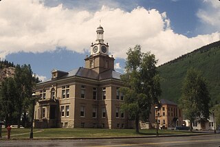
The Hinsdale County Historical Society formed in 1973 and began accumulating documents and photographs recording the town's history. In 1978, the Lake City Historic District was listed in the National Register of Historic Places. Residents have restored many of the boom town mining era buildings and currently promote tourism as an industry. Restoration has not only aided the local economy by making Lake City a desirable tourist destination, it has served economic development with preservation projects creating jobs for local carpenters, craftsmen, and contractors. Lake City's educational needs are served by the Lake City Community School.
Early history
Prior to written history, the Ute people lived in this area of the San Juan Mountain Range where they hunted and fished in the high mountain valleys during the summers. Even though the land was owned by the Utes as part of a treaty that set the area aside as a tribal reservation, by the 1860s prospectors had begun to enter the region in search of minerals. When rich silver deposits were found in the Lake City area, word spread, and pressure was put on the federal government to negotiate a new treaty with the Utes. Consequently, the native population was again pushed from their lands when in 1873, a new treaty was negotiated under which the Utes gave up their rights to the San Juan Mountains. In 1873, the town of Lake City was incorporated as a supply center for the prospectors and miners who were flooding the area.[10]
Lake City was platted in fall 1874 during construction of the Saguache & San Juan Wagon Toll Road, which opened the San Juan region for settlement. Town developers chose this location for the town site because of its flat terrain and abundant water. The broad valley provided a park-like setting which the optimistic town developers used to their advantage. They laid out a 260-acre town site that occupied the entire valley floor - 72 blocks of 32 uniform city lots, 25' x 125' in size. To promote the speculative town, Otto Mears subsidized The Silver World newspaper and published the first issue on June 19, 1875. It was the first newspaper published on the Western Slope.[11]
It was not unusual for mining towns to grow into boom towns within a matter of only a few months, and Lake City was no exception. Promoted as the "Metropolis of San Juan", the town flourished as a distribution point for goods and supplies forwarded to mines and camps in the northern Hinsdale County mining districts. The initial influx of pioneers, prospectors, and miners attracted scores of merchants and dozens of lawyers and assayers to provide goods, supplies, and services. Merchants profited by outfitting the surge of prospectors who flooded into the area in 1876 and 1877 and by supplying dozens of mines in the outlying mining districts. The early boom years brought the usual red-light district to Lake City as was seen in any male-dominated mining town of that period. Records from 1878 show that the city had two breweries and a "Hell's Acre" district with 20 saloons, dance halls, and brothels. Lake City had as many as 3,000 to 5,000 residents at one time. But despite this promising activity, northern Hinsdale County's mining districts lacked the three key factors in mining development: year-round transportation, abundant ore, and capital to finance development of underground workings, and by 1879, the boom had subsided.[11][12] Constructed of rapidly built wooden structures, much of the town was destroyed by a fire in 1879. The town was rebuilt using brick and stone, and consequently many of those structures remain today. By this time Lake City was manufacturing its own building materials using local lumber, locally quarried stone, and bricks made from clay obtained at the nearby Slumgullion Earthflow. The weekly Lake City Mining Register newspaper was published 1880-85. By 1884, the population was beginning to dwindle, but the arrival of the Denver & Rio Grande Railroad on narrow-gauge tracks that were laid in 1889 cut the cost of shipping gold and silver ores to smelters, and the economy saw an upturn which extended into the 1890s.[10]
Denver and Rio Grande Railroad
In 1889, the Denver and Rio Grande Railroad finished laying track from Sapinero to Lake City; the distance spanned 36 miles, with 10 bridges. The "High Bridge" was 800 feet long and 113 feet high. The train averaged 12 miles per hour. According to local residents, "You didn’t want the Rio Grande engine to run over you because 'it was on you so long'."[citation needed] The final cost of the construction of the branch was $770,996.80, a considerable sum at the time.[13] The local newspaper welcomed the arrival of the D&RG:[14]
"The town has awakened from its long sleep; new people and new enterprises are coming in at a rapid rate; outside capital is coming to the rescue, and Lake City is on the eve of a prosperity such as it has never seen before. Mines that have been practically untouched for years are now being profitably worked under the impetus given by ample shipping facilities and cheaper rates; the stores and residences that have been so long vacant are rapidly filling up, and the patient people who have endured the horrors and the hardships of business inactivity for years now wear the smile of gladness and joy."
The Denver & Rio Grande line had additional impacts. The railroad bolstered the ranching industry by shipping cattle raised on ranches along the Lake Fork and by bringing sheep for summer grazing along the Lake Fork valley in northern Hinsdale County. It also linked the isolated location with the rest of the state and nation, encouraging sportsmen and tourists to visit the upper Lake Fork.[14]
Golden Fleece Mine
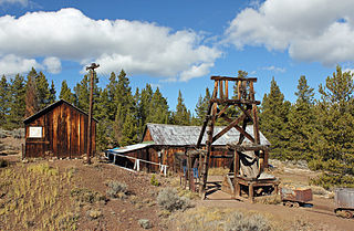
In 1874, Enos T. Hotchkiss filed a claim five miles south of Lake City which led to the development of the Golden Fleece Mine. Results from preliminary work in the mine were promising, and assay determination indicated the property was rich in high grade telluride and gold ore at a short distance below the surface. But in November 1876, work on the Hotchkiss mine came to an abrupt halt when Hotchkiss was severely injured from a 30-foot fall down a mine shaft. After lying idle for many months, the mine was sold at a sheriff's sale. With new ownership, a rich vein of gold and a large vein of rich telluride ore were discovered in 1892, with one carload valued at more than $19,000. By 1904, it had produced $1,400,000 in silver and gold ore. The ruins of buildings at the Golden Fleece mine are still visible today.[15][16][17]
Alferd Packer
Harper's Weekly, October 17, 1874, issue. Illustration by John A. Randolph of the scene of "A Colorado Tragedy". Photo taken from an original copy.
In 1875, Lake City gained notoriety when Alferd Packer was charged with murder and cannibalism. Due to the nature of the crime, it was sensationalized and gained national attention. There are several differing accounts of the story, but according to one account Packer was acting as a guide for a party of five men prospecting in the San Juan Mountains when they became snowbound for the winter.
When he eventually came out of the mountains in the spring, he said the miners had abandoned him and he had nearly starved. However, because he looked surprisingly healthy and first asked for whiskey rather than food, suspicions began to arise. Five bodies that showed signs of cannibalism were found southeast of Lake City at the foot of Slumgullion Pass, and Packer was arrested and held in the Saguache jail, but escaped. He fled to Cheyenne, Wyoming, where he remained until 1883 when he was again arrested and brought to Lake City for trial. He was convicted of killing one of the five men and sentenced to be hanged. The Colorado Supreme Court reversed the conviction in 1885, but the following year Packer was retried, convicted again, and sentenced to 40 years. He was paroled and released in 1901.[10]
The Hinsdale County Museum, in downtown Lake City, hosts the most extensive collection of Packer memorabilia known, including a skull fragment from one of his victims, a pair of shackles used on Alferd when he was in the Lake City jail, a number of buttons from the clothes of the five men he eventually ate, and dolls and the dollhouse Packer built while in the Lake City Jail.[18][19] The area where the bodies were discovered is now known as Cannibal Plateau.[20] Packer is remembered by holding an annual Alferd Packer Jeep Tour and Barbecue.[20] The cafeteria in the University of Colorado, Boulder student union is called the Alferd Packer Memorial Grill.[18][20]
End of the economic boom days
Despite the several booms that were seen in Lake City, it remained a quiet and peaceful village, perhaps because Lake City was founded by the powerful men of the time, such as Otto Meirs, who were speculating on a mineral wealth not yet discovered rather than on actual discoveries of any vastly rich mineral deposits. This village developed by building homes and businesses and moving families in rather than following the pattern of boom towns built for a boom crowd of prospectors having heard of a rich find and hoping to quickly strike it rich, as well. Lake City had four churches, a ball park, and a school, but unlike other boom towns - such as Leadville - few saloons or brothels.[11]
By 1905, the mining era was over and Lake City entered a decades-long period of economic decline. Population figures hovered at 1,000 then dropped to 400 after 1910. Although mining continued throughout the twentieth century, it consisted primarily of exploration and speculation rather than productive operation. Beginning in 1915, visitors began coming to Lake City for the entire summer season, and by the 1930s tourism had emerged as a viable industry. Although a number of properties were lost to fire or deterioration, the prolonged slump protected many of the town's historic properties from substantial alterations or from demolition as has occurred to many other 1870s buildings in Colorado.[11]
Tourism
In the first half of the twentieth century, Lake City's economic base shifted from mining to tourism. People had recognized the area's scenic and recreational resources from the earliest days, however, Lake City's remote location had discouraged visitors. Until the branch of the Denver & Rio Grand Railroad line was completed in 1889, people journeyed by stagecoach 100 miles from Saguache or 140 miles from Del Norte. The rustic Lake Shore Inn opened at Lake San Cristobal in 1917, signaling the era of tourism that has continued into the twenty-first century.[11]
Beginning around 1920, visitors began arriving at Lake City by automobile. This trend grew as highways were developed to Colorado's western slope and roads were improved in Hinsdale County. Early auto tourists stayed in the mining era hotels. Lake City's first auto tourist court opened in 1929. From the 1930s through the 1960s, a half dozen or so tourist accommodations opened each decade in Lake City and along the Lake Fork.[11]
Lake City's mountain environs offered an array of outdoor recreation that encompassed fishing, hunting, boating, mountain climbing, horseback riding, hiking, tent camping, and picnicking. Local merchants accommodated sportsmen; for example, Last Chance Livery and Feed Stable advertised "Fine Saddle Horses" and "Special Arrangements for Fishing and Hunting Parties" at the turn of the century. Lake City Café and Bakery offered to "cook your trout" and packed picnic lunches for visitors. An early booster club promoted boat racing on Lake San Cristobal. Within town, diversions included horse and bicycle racing around a quarter mile-circular track built about 1910 at Ball Flats. Sportsmen were invited to Lake City's "happy hunting grounds" and promised "if you make Lake City your camp headquarters you can be sure of bagging your buck." Game included deer, elk, bear, bighorn sheep, and wild turkey. Uncompahgre Peak and the surrounding mountains were covered by abandoned mining roads that became hiking trails, routes for trail rides and pack rides, and, later, jeep roads.[11]
In the 1930s and 1940s, Lake City's isolated location and deteriorating buildings gave tourists and summer residents a sense of escaping from civilization. As in other isolated mountain towns, bootlegging and gambling created the allure of lawlessness. In 1949, a Denver Post reporter spoke of the town's numerous slot machines: "Virtually every business place in Lake City has one or more machines… The post office and telephone office are almost the only exceptions."[11]
Lake City National Historic District
Baptist Church in Lake City, Colorado
The Lake City Historic District contains a collection of intact buildings associated with the 1875-1881 boom as well as buildings constructed during the second boom period of the 1890s. The town's remote location and decades of economic decline helped conserve the buildings from the mining era, and the weak local economy discouraged new construction; thus Lake City avoided many of the modern "improvements" to historic buildings that often occurs in more prosperous towns. The Hinsdale County Historical Society formed in 1973 and began accumulating documents and photographs recording the town's history, and has been a strong advocate for preservation in Lake City since then. In 1978, the Lake City Historic District was listed in the National Register of Historic Places.[11]
In some cases restoration was as simple as removing a coat of paint from a brick building or removing a wood facade from an early building faced with stone, but in other cases more involved restoration was required. During the 1970s and 1980s, volunteers performed extensive preservation work on the Baptist church building, which had stood vacant and derelict in the 1930s. Hinsdale County acquired the John C. Bell cabin at 304 Third Street and restored it in 2000, removing stucco siding to reveal the 1876 log cabin that had served as the law office for Lake City's leading attorney in the 1880s. Also, many individual property owners have done restoration and upkeep to preserve their historic properties. Restoration has not only aided the local economy by making Lake City a desirable tourist destination, it has also served economic development with preservation projects creating jobs for local carpenters, craftsmen, and contractors. [11]
According to the United States Census Bureau, the town has a total area of 0.9 square miles (2.3km2), of which, 0.8 square miles (2.1km2) of it is land and 1.18% is water.[21]
In recent years, Lake City has become a destination for many Texans who bring their ATVs to ride the many rugged 2WD and 4WD roads in the area. Lake City is also known to many Colorado fourteener "peakbaggers" as the jumping-off point for five of Colorado's 53 ranked 14,000' peaks - Sunshine, Redcloud, Handies, Wetterhorn, and Uncompahgre.[22]
Lake City experiences a continental climate (Köppen climate classificationDfb) that only just escapes being classified as semi-arid due to its relatively wet early springs and late autumns. On average, the wettest month is August, and the driest is February. Very large daily temperature swings are a regular feature of Lake City's climate, due to the elevation and aridity.[citation needed]
Climate data for Lake City, Colorado, 1991–2020 normals, extremes 1905–2010
The San Juan Mountains is a high and rugged mountain range in the Rocky Mountains in southwestern Colorado and northwestern New Mexico. The area is highly mineralized and figured in the gold and silver mining industry of early Colorado. Major towns, all old mining camps, include Creede, Lake City, Silverton, Ouray, and Telluride. Large scale mining has ended in the region, although independent prospectors still work claims throughout the range. The last large-scale mines were the Sunnyside Mine near Silverton, which operated until late in the 20th century, and the Idarado Mine on Red Mountain Pass, which closed in the 1970s. Famous old San Juan mines include the Camp Bird and Smuggler Union mines, both located between Telluride and Ouray.
Leadville is a statutory city that is the county seat, the most populous community, and the only incorporated municipality in Lake County, Colorado, United States. The city population was 2,633 at the 2020 census. It is situated at an elevation of 10,158 feet (3,096 m). Leadville is the highest incorporated city in the United States and is surrounded by two of the tallest peaks in the state.
San Juan County is a county located in the U.S. state of Colorado. As of the 2020 census, the population was 705, making it the least populous county in Colorado. The county seat and the only incorporated municipality in the county is Silverton. The county name is the Spanish language name for "Saint John", the name Spanish explorers gave to a river and the mountain range in the area. With a mean elevation of 11,240 feet, San Juan County is the highest county in the United States and also has the two highest elevation houses in the United States; the ‘Bonnie Belle’ above Animas Forks at 11,900’ – 11,950’ elevation and an unnamed house above Picayune Gulch at 12,000’ elevation.
The Town of Ridgway is the home rule municipality that is the most populous municipality in Ouray County, Colorado, United States. The town is a former railroad stop on the Uncompahgre River in the northern San Juan Mountains. The town population was 1,183 at the 2020 census.
Saguache is a Statutory Town in and the county seat of Saguache County, Colorado, United States. The population was 539 at the United States Census 2020.
Silverton is a statutory town that is the county seat, the most populous community, and the only incorporated municipality in San Juan County, Colorado, United States. The town is located in a remote part of the western San Juan Mountains, a range of the Rocky Mountains. The first mining claims were made in mountains above the Silverton in 1860, near the end of the Colorado Gold Rush and when the land was still controlled by the Utes. Silverton was established shortly after the Utes ceded the region in the 1873 Brunot Agreement, and the town boomed from silver mining until the Panic of 1893 led to a collapse of the silver market, and boomed again from gold mining until the recession caused by the Panic of 1907. The entire town is included as a federally designated National Historic Landmark District, the Silverton Historic District.
Alfred Griner Packer, also known as the "Colorado Cannibal", was an American prospector and self-proclaimed wilderness guide who confessed to cannibalism during the winter of 1874. After emerging as the sole survivor of a six-man party who had attempted to travel through the San Juan Mountains of the Colorado Territory, he eventually confessed to having lived off the flesh of his companions, giving more than one version of his account as to the circumstances.
The Western Slope is a colloquial term generally understood to describe the part of the state of Colorado west of the Continental Divide. Bodies of water west of the Divide flow toward the Pacific Ocean; water that falls and flows east of the Divide heads east toward the Gulf of Mexico. The Western Slope encompasses about 33% of the state, but has just 10% of the state's residents. The eastern part of the state, including the San Luis Valley and the Front Range, is the more populous portion of the state.
The Colorado Silver Boom was a dramatic expansionist period of silver mining activity in the U.S. state of Colorado in the late 19th century. The boom started in 1879 with the discovery of silver at Leadville. Over 82 million dollars worth of silver was mined during the period, making it the second great mineral boom in the state, and coming 20 years after the earlier and shorter Colorado Gold Rush of 1859. The boom was largely the consequence of large-scale purchases of silver by the United States Government authorized by Congress in 1878. The boom endured throughout the 1880s, resulting in an intense increase in both the population and wealth of Colorado, especially in the mountains. It came to an end in 1893 in the wake of the collapse of silver prices caused by the repeal of Sherman Silver Purchase Act.
Gilman is an abandoned mining town in southeastern Eagle County, Colorado, United States. The Gilman post office operated from November 3, 1886, until April 22, 1986. The U.S. Post Office at Minturn now serves Gilman postal addresses.
Uncompahgre National Forest is a U.S. National Forest covering 955,229 acres in parts of Montrose, Mesa, San Miguel, Ouray, Gunnison, Hinsdale, San Juan, and Delta Counties in western Colorado. Its headquarters are in Delta County, in the city of Delta. It borders the San Juan National Forest to the south.
The Rio Grande Southern Railroad was a 3 ft (914 mm) narrow-gauge railroad which ran in the southwestern region of the US state of Colorado, from the towns of Durango to Ridgway, routed via Lizard Head Pass. Built by German immigrant and Colorado toll road builder Otto Mears, the RGS operated from 1891 through 1951 and was built with the intent to transport immense amounts of silver mineral traffic that were being produced by the mining communities of Rico and Telluride. On both ends of the railroad, there were interchanges with The Denver and Rio Grande Railroad, which would ship the traffic the RGS hauled elsewhere like the San Juan Smelter in Durango.
Granite is an unincorporated community with a U.S. Post Office in Chaffee County, Colorado, United States. The zip code of Granite is 81228. According to the 2010 census, the population is 116.
The Lake Fork of the Gunnison River begins in high mountains in the western region of Colorado, United States, draining the northeastern part of the San Juan Mountains.
Gold mining in Colorado, a state of the United States, has been an industry since 1858. It also played a key role in the establishment of the state of Colorado.
The Leadville mining district, located in the Colorado Mineral Belt, was the most productive silver-mining district in the state of Colorado and hosts one of the largest lead-zinc-silver deposits in the world. Oro City, an early Colorado gold placer mining town located about a mile east of Leadville in California Gulch, was the location to one of the richest placer gold strikes in Colorado, with estimated gold production of 120,000–150,000 ozt, worth $2.5 to $3 million at the then-price of $20.67 per troy ounce.
This is an alphabetical list of articles related to the U.S. State of Colorado.
The Golden Fleece Mine is a gold mining site in Hinsdale County, Colorado, 5 miles (8 km) south of Lake City. The mine is located half a mile west of the north end of Lake San Cristobal. By 1904 it had produced $1,400,000 in silver and gold ore. The mine operated intermittently until 1919. Later, in the mid-1960s, some renewed interest in the property came up, especially in the Hiwassee lode area of the mine, but other than a couple of small test shipments, there is no recorded production until today.
Emil B. Fischer published six detailed maps of the San Juan area of southwestern Colorado between 1883 and 1898. A surveyor's son, he came to America around 1872. He moved to Durango in 1880 when the building of the Denver & Rio Grande Railway to the San Juan attracted widespread attention, then to Silverton. These maps aided silver and gold prospectors to file their claims; they enabled investors to locate mines and view their proximity to famous neighboring mines; and they encouraged tourists to visit the depicted mining regions and invigorate the local economies.
1 2 3 Leach, John (September 1, 2013). "Lake City History". Colorado Travel. Archived from the original on January 21, 2015. Retrieved January 23, 2015.
↑ Portrait and Biographical Record of Denver and Vicinity Colorado, Containing Portraits and Biographies of many well known Citizens of the Past and Present together with Biographies and Portraits of all the Presidents of the United States (portraited person: Charles H. Davis). Chicago: Chapman Publishing Company. 1898. pp.791–792.
↑ Holmes, Richard Walker; Kennedy, Marrianna B. (1983). Mines and minerals of the Great American Rift (Colorado-New Mexico). Van Nostrand Reinhold. pp.180–185. ISBN978-0-442-28038-3.
This page is based on this Wikipedia article Text is available under the CC BY-SA 4.0 license; additional terms may apply. Images, videos and audio are available under their respective licenses.