Shasta Lake, also popularly known as Lake Shasta, is a reservoir in Shasta County, California, United States. It began to store water in 1944 due to the impounding of the Sacramento River by Shasta Dam, the ninth tallest dam in the United States.

Lake Nacimiento is an 18-mile (29 km) long lake on the Nacimiento River in northern San Luis Obispo County, California. The lake contains many arms including Snake Creek and Dip Creek, nearer the dam, and the central Las Tablas and Franklin Creeks.

The Wildflower Triathlon is a triathlon held at Lake San Antonio in Central California since 1983, the first winner being Dean "The Machine" Harper. It is held the first weekend in May each year.

Donner Lake, formerly known as Truckee Lake, is a freshwater lake in Northeast California on the eastern slope of the Sierra Nevada and about 20 miles (32 km) northwest of the much larger Lake Tahoe. A moraine serves as a natural dam for the lake. The lake is located in the town of Truckee, between Interstate 80 to the north and Schallenberger Ridge to the south. The tracks of the Union Pacific Railroad run along Schallenberger Ridge and closely follow the route of the original transcontinental railroad. The historic route of the Lincoln Highway, the first automobile road across America and US 40 follows the northern shoreline, then climbs to Donner Pass from where the entire lake may be viewed.
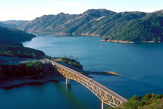
Lake Sonoma is a reservoir west of Cloverdale in northern Sonoma County, California, created by the construction of Warm Springs Dam. The lake provides water for countywide growth and development, and for recreation.

Lake Oroville is a reservoir formed by the Oroville Dam impounding the Feather River, located in Butte County, northern California. The lake is situated 5 miles (8 km) northeast of the city of Oroville, within the Lake Oroville State Recreation Area, in the western foothills of the Sierra Nevada. Known as the second-largest reservoir in California, Lake Oroville is treated as a keystone facility within the California State Water Project by storing water, providing flood control, recreation, freshwater releases to assist in controlling the salinity intrusion into the Sacramento-San Joaquin Delta and protecting fish and wildlife.

Lake Havasu is a large reservoir formed by Parker Dam on the Colorado River, on the border between San Bernardino County, California and Mohave County, Arizona. Lake Havasu City sits on the Arizonan side of the lake with its Californian counterpart of Havasu Lake directly across the lake. The reservoir has an available capacity of 619,400 acre-feet (764,000,000 m3). The concrete arch dam was built by the United States Bureau of Reclamation between 1934 and 1938. The lake's primary purpose is to store water for pumping into two aqueducts. Prior to the dam construction, the area was home to the Mojave people. The lake was named after the Mojave word for blue. In the early 19th century, it was frequented by beaver trappers. Spaniards also began to mine the areas along the river.

The San Luis Reservoir is an artificial lake on San Luis Creek in the eastern slopes of the Diablo Range of Merced County, California, approximately 12 mi (19 km) west of Los Banos on State Route 152, which crosses Pacheco Pass and runs along its north shore. It is the fifth largest reservoir in California. The reservoir stores water taken from the San Joaquin-Sacramento River Delta. Water is pumped uphill into the reservoir from the O'Neill Forebay which is fed by the California Aqueduct and is released back into the forebay to continue downstream along the aqueduct as needed for farm irrigation and other uses. Depending on water levels, the reservoir is approximately nine miles (14 km) long from north to south at its longest point, and five miles (8 km) wide. At the eastern end of the reservoir is the San Luis Dam, the fourth largest embankment dam in the United States, which allows for a total capacity of 2,041,000 acre-feet (2,518,000 dam3). Pacheco State Park lies along its western shores.

Lake Dardanelle is a major reservoir on the Arkansas River in Arkansas, USA. and is an integral part of the McClellan-Kerr Arkansas River Navigation System (MKARNS), which allows barge transportation from the Mississippi River to the Tulsa Port of Catoosa in northeastern Oklahoma. MKARNS went into service along its full length in 1971.

The Nacimiento River is a 64.8-mile-long (104.3 km) river in southern Monterey County and northern San Luis Obispo County, California. A large portion of the river's run is on military reservations. The river's upper reaches are inside Fort Hunter Liggett, Lake Nacimiento is in the middle and the lower reaches are inside Camp Roberts. It is the largest tributary of the Salinas River in terms of streamflow.

Folsom Lake is a reservoir on the American River in the Sierra Nevada foothills of California, United States.

New Hogan Lake is an artificial lake in the foothills of the Sierra Nevada in Calaveras County, California, about 30 miles (48.3 km) northeast of Stockton. It is formed by New Hogan Dam on the Calaveras River, whose North and South forks combine just upstream of the lake, and has a capacity of 317,000 acre⋅ft (391,000,000 m3). The earth-fill dam, completed in 1963, is 210 feet (64.0 m) high from the crest of the dam to the original streambed. The reservoir was first filled in 1965. There is a small hydroelectric plant at its base. It is owned by the United States Army Corps of Engineers and provides flood protection, drinking water, electricity and water for irrigation. There is also recreation available, such as boating, fishing, water skiing and camping.

Lake Almanor is a large reservoir in northwestern Plumas County, northeastern California, United States. The reservoir has a capacity of 1,308,000 acre-feet (1.613×10⁹ m3) and a maximum depth of about 90 feet (27 meters). It is formed by Canyon Dam on the North Fork of the Feather River, as well as Benner and Last Chance Creeks, Hamilton Branch, and various natural springs.

Lake Mendocino is a large reservoir in Mendocino County, California, northeast of Ukiah. It covers 1,922 acres (7.78 km2) and was formed by the construction of Coyote Valley Dam in 1958. The lake and dam provide flood control, water conservation, hydroelectric power, and recreation. The dam also includes a fallout shelter built during the Cold War era to protect against the radiation from nuclear attacks from the Soviet Union.
Lake Perris is an artificial lake completed in 1973. It is the southern terminus of the California State Water Project, situated in a mountain-rimmed valley between Moreno Valley and Perris, in what is now the Lake Perris State Recreation Area. The park offers a variety of recreational activities. Because of this and the lake's proximity to major population centers, it is very crowded during the summer months.
Lake Chabot is a man-made lake covering 317 acres (1.3 km2) in Alameda County, California, United States. Part of the lake lies within Oakland city limits, but most of it lies in unincorporated Castro Valley, just east of San Leandro. It was formed by the damming of San Leandro Creek. The lake was completed in 1875 to serve as a primary source of water for the East Bay.

Lake Natoma is a small lake in the western United States, along the lower American River, between Folsom and Nimbus Dams in Sacramento County, California. The lake is located within the Folsom Lake State Recreation Area which is responsible for maintaining the facilities and bike trails surrounding the lake. Lake Natoma is located 15 miles east of Sacramento, and has 500 surface acres of water. The total length of lake Natoma is 4 miles.

Englebright Lake is an 815 acre reservoir on the Yuba River, impounded by Englebright Dam, in the Sierra Nevada, Northern California, United States. The reservoir stores 45,000 acre feet of water with nearly 24 miles of shoreline.

Bonham State Park is a 261-acre (1.06 km2) state park located in Bonham, Texas. It includes a 65-acre (260,000 m2) lake, rolling prairies, and woodlands.

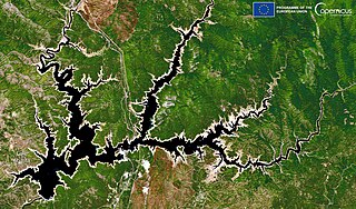
Nacimiento Dam is a dam on the Nacimiento River about 10 miles (16 km) northwest of Paso Robles, California in the United States. The primary purpose of the dam is to provide groundwater recharge for agriculture in Monterey County and northern San Luis Obispo County supported by the Salinas Valley aquifer, as well as flood control, domestic water supply, and hydropower. It forms Lake Nacimiento, popular for boating, fishing and camping, and known locally as the "Dragon Lake" due to its shape.


