Santa Margarita, California

Last updated
Santa Margarita, California
Downtown Santa Margarita.jpg
Downtown Santa Margarita, 2011
USA California location map.svg
Red pog.svg
Santa Margarita, California
Location within the State of California
Coordinates: 35°23′22″N120°36′29″W / 35.38944°N 120.60806°W / 35.38944; -120.60806
Country United States
State California
County San Luis Obispo
Area
[1]
  Total0.518 sq mi (1.341 km2)
  Land0.518 sq mi (1.341 km2)
  Water0 sq mi (0 km2)  0%
Elevation
[2]
1,014 ft (309 m)
Population
 (2010)
  Total1,259
  Density2,400/sq mi (940/km2)
Time zone UTC-8 (Pacific (PST))
  Summer (DST) UTC-7 (PDT)
ZIP codes
93453
Area code 805
GNIS feature ID2583128
The narrow-gauge steam train is a popular attraction at the historic Santa Margarita Ranch. Pacific Coast RR, Sta Margarita Ranch.jpg
The narrow-gauge steam train is a popular attraction at the historic Santa Margarita Ranch.

Santa Margarita (Spanish for "St. Margaret") is a town and census-designated place located in San Luis Obispo County, California. [2] It was founded in 1889 near Cuesta Peak and San Luis Obispo along State Route 58. The town's name comes from the Mexican Alta California land grant of Rancho Santa Margarita. It is home to the Santa Margarita de Cortona Asistencia site. The population was 1,259 at the 2010 census.

Contents

History

Santa Margarita was named for the 13th-century Saint Margaret of Cortona (1247–1297). [3]

Santa Margarita Valley, with its year-round running streams and abundant acorns, was a meeting place for northern Chumash and southern Salinan around 6500 BCE. The de Anza Expedition traversed the Cuesta Grade into the valley in 1776. After Fr. Junipero Serra founded the Mission San Luis Obispo de Tolosa, he realized that an assistancia (sub-mission) was needed. The Santa Margarita de Cortona Asistencia was founded circa 1775, and was named for the Italian Saint, Santa Margarita de Cortona. The Spanish El Camino Real trail past it is the city's present-day main street.

In 1841, following Mexico's 1822 independence and 1830s mission secularization, Joaquin Estrada became the owner of the Rancho Santa Margarita. Estrada was famed for his "Rancho Hospitality" with rodeos, BBQs and fiestas. After downturns in the economy and personal debts, Estrada sold the Rancho to the Martin Murphy family in 1860.

Patrick Murphy worked to restore the Rancho to a working agricultural ranch. On April 20, 1889, the Southern Pacific Railroad reached Santa Margarita from Templeton. A "Grand Auction" was held to sell lots for the new town of Santa Margarita along the El Camino Real. While construction down the Cuesta Grade took place, the railroad terminus was in Santa Margarita. This created a boom time in the community. All freight had to be loaded for stage transportation up and down the Cuesta Grade. Town boasted a hotel, restaurants, taverns, blacksmiths, and ice cream parlors. Once the "gap" was closed from Santa Margarita to San Luis Obispo in 1894 the town grew quiet.

Margarita Town saw a renaissance in the roaring 1920s. The El Camino Real was one of the primary roads for seeing California. The town offered a motor inn, hotel, six gas stations, garages, pool halls, restaurants, fraternal organizations, taverns and a baseball team.

The Depression hit the town and surrounding areas hard. The War Department took land from local farmers to build a reservoir on the Salinas River which created Santa Margarita Lake to provide water for Camp San Luis. The war ended before the work was completed and Santa Margarita Lake is now a County Recreation Area.

After Highway 101 bypassed Santa Margarita in 1956, the town was quiet once again. Today, it's a small town of 1,300 people. It is a quiet artist and family community. [4] [5]

Geography

Located in the foothills of the Santa Lucia Mountains, it is one of the most rural communities in San Luis Obispo County. Santa Margarita Lake, a major water source for San Luis Obispo, is located several miles southeast of the town on the headwaters of the Salinas River. It is served by ZIP code 93453 and area code 805.

According to the United States Census Bureau, the CDP covers an area of 0.5 square miles (1.3 km2), all of it land.

Demographics

The 2010 United States Census [6] reported that Santa Margarita had a population of 1,259. The population density was 2,432.4 inhabitants per square mile (939.2/km2). The racial makeup of Santa Margarita was 1,077 (85.5%) White, 8 (0.6%) African American, 28 (2.2%) Native American, 34 (2.7%) Asian, 0 (0.0%) Pacific Islander, 42 (3.3%) from other races, and 70 (5.6%) from two or more races. Hispanic or Latino of any race were 206 persons (16.4%).

The Census reported that 1,259 people (100% of the population) lived in households, 0 (0%) lived in non-institutionalized group quarters, and 0 (0%) were institutionalized.

There were 507 households, out of which 151 (29.8%) had children under the age of 18 living in them, 254 (50.1%) were opposite-sex married couples living together, 52 (10.3%) had a female householder with no husband present, 16 (3.2%) had a male householder with no wife present. There were 52 (10.3%) unmarried opposite-sex partnerships, and 1 (0.2%) same-sex married couples or partnerships. 124 households (24.5%) were made up of individuals, and 29 (5.7%) had someone living alone who was 65 years of age or older. The average household size was 2.48. There were 322 families (63.5% of all households); the average family size was 2.98.

The population was spread out, with 257 people (20.4%) under the age of 18, 112 people (8.9%) aged 18 to 24, 321 people (25.5%) aged 25 to 44, 461 people (36.6%) aged 45 to 64, and 108 people (8.6%) who were 65 years of age or older. The median age was 41.1 years. For every 100 females there were 101.8 males. For every 100 females age 18 and over, there were 97.6 males.

There were 525 housing units at an average density of 1,014.3 per square mile (391.6/km2), of which 334 (65.9%) were owner-occupied, and 173 (34.1%) were occupied by renters. The homeowner vacancy rate was 1.5%; the rental vacancy rate was 2.3%. 832 people (66.1% of the population) lived in owner-occupied housing units and 427 people (33.9%) lived in rental housing units.

Related Research Articles

<span class="mw-page-title-main">San Luis Obispo County, California</span> County in California, United States

San Luis Obispo County, officially the County of San Luis Obispo, is a county on the Central Coast of California. As of the 2020 census, the population was 282,424. The county seat is San Luis Obispo.

<span class="mw-page-title-main">Las Flores, California</span> Place in California, United States

Las Flores is an unincorporated census-designated place (CDP) in Orange County, California, located adjacent to the City of Rancho Santa Margarita, California. The population was 5,971 at the 2010 census, up from 5,625 at the 2000 census. Las Flores does not have its own ZIP Code and is served by the same ZIP Code as adjacent Rancho Santa Margarita, 92688. The Rancho Santa Margarita dog/skate park is located in the CDP and is served by the Orange County Sheriff's Dept. and Orange County Fire Authority. Although Las Flores lies in the land grant of Rancho Mission Viejo, it is named after the land grant about 25 miles south Rancho Santa Margarita y Las Flores.

<span class="mw-page-title-main">Rancho Santa Margarita, California</span> City in California, United States

Rancho Santa Margarita is a city in Orange County, California, United States. One of Orange County's youngest cities, Rancho Santa Margarita is a master-planned community. The population was 47,853 at the 2010 census, up from 47,214 at the 2000 census. Although it is named for Rancho Santa Margarita y Las Flores, which was in San Diego County, the city limits fall within the borders of Rancho Mission Viejo. At 20 characters long, it is the longest city name in California.

<span class="mw-page-title-main">Atascadero, California</span> City in California, United States

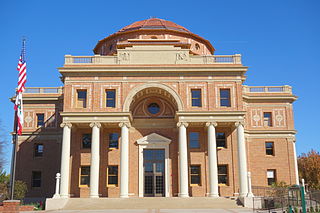
Atascadero is a city in San Luis Obispo County, California, United States, located on U.S. Route 101. Atascadero is part of the San Luis Obispo-Paso Robles metropolitan statistical area, which encompasses the extents of the county. Atascadero is farther inland than most other cities in the county, and as a result, usually experiences warmer, drier summers, and cooler winters than other nearby cities such as San Luis Obispo and Pismo Beach. The main freeway through town is U.S. 101. The nearby State Routes 41 and 46 provide access to the Pacific Coast and the Central Valley of California.

<span class="mw-page-title-main">Cambria, California</span> Place in California, United States

Cambria is a seaside village in San Luis Obispo County, California, United States midway between San Francisco and Los Angeles along California State Route 1. The name Cambria, chosen in 1869, is the Latin name for Wales. Cambria is situated amidst Monterey pines in one of only three such native forests. The town previously had gone by the names of Slabtown, Rosaville, San Simeon, and Santa Rosa.

<span class="mw-page-title-main">Nipomo, California</span> Place in California, United States

Nipomo is an unincorporated town in San Luis Obispo County, California, United States. The population was 16,714 for the 2010 census and grew to 18,176 for the 2020 census. For statistical purposes, the United States Census Bureau has defined Nipomo as a census-designated place (CDP).

<span class="mw-page-title-main">San Luis Obispo, California</span> City in California, United States

San Luis Obispo is a city and county seat of San Luis Obispo County, in the U.S. state of California. Located on the Central Coast of California, San Luis Obispo is roughly halfway between the San Francisco Bay Area in the north and Greater Los Angeles in the south. The population was 47,063 at the 2020 census.

<span class="mw-page-title-main">Los Alamos, California</span> Place in California, United States

Los Alamos is an unincorporated community in Santa Barbara County, California, United States. Located in the Los Alamos Valley, the town of Los Alamos is considered to be a part of the Santa Ynez Valley community. Los Alamos is also connected to other cities Vandenberg SFB, Lompoc, Buellton, Solvang, and other Santa Barbara County cities. It is 140 miles northwest of Los Angeles and 281 miles (452 km) south of San Francisco. The population was 1,890 at the 2010 census, up from 1,372 at the 2000 census. For statistical purposes, the United States Census Bureau has defined Los Alamos as a census-designated place (CDP).

<span class="mw-page-title-main">San Simeon, California</span> Small community on the coast of California

San Simeon is a village and Census-designated place on the Pacific coast of San Luis Obispo County, California, United States. Its position along State Route 1 is about halfway between Los Angeles and San Francisco, each of those cities being roughly 230 miles (370 km) away. A key feature of the area is Hearst Castle, a hilltop mansion built for William Randolph Hearst in the early 20th century that is now a tourist attraction. The area is also home to a large northern elephant seal rookery, known as the Piedras Blancas rookery, located 7 miles (11 km) north of San Simeon on Highway 1.

Rancho Santa Margarita was a 17,735-acre (71.77 km2) Mexican land grant in the Santa Lucia Mountains, in present day San Luis Obispo County, central California.

<span class="mw-page-title-main">Santa Margarita de Cortona Asistencia</span> 18th-century Spanish asistencia in California

The Santa Margarita de Cortona Asistencia was established in 1787 as an asistencia ("sub-mission") to Mission San Luis Obispo de Tolosa, then in the Spanish Las Californias Province. Its site is near the present-day city of Santa Margarita, in San Luis Obispo County, central California.

<span class="mw-page-title-main">Avila Beach, California</span> Place in California, United States

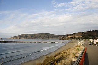
Avila Beach is an unincorporated community in San Luis Obispo County, California, United States, located on San Luis Obispo Bay about 160 miles (257 km) northwest of Los Angeles, and about 200 miles (320 km) south of San Francisco. The population was 1,576 at the 2010 census. For statistical purposes, the United States Census Bureau has defined Avila Beach as a census-designated place (CDP).

<span class="mw-page-title-main">Cuyama, California</span> Census-designated place in California, United States

Cuyama is a census-designated place in Santa Barbara County. California. It is located in the Cuyama Valley, near the Carrizo Plain. The Cuyama River runs adjacent to the town, flowing west towards the Pacific Ocean. Cuyama is surrounded by many apricot, peach, and plum orchards. The ZIP Code is 93254, and the community is inside area code 805. The population was 57 at the 2010 census. The name "Cuyama" comes from an Indian village named Kuyam.

Santa Margarita, Spanish for Saint Margaret, may refer to:

<span class="mw-page-title-main">Santa Nella, California</span> Census designated place in California, United States

Santa Nella is an unincorporated village and census-designated place (CDP) in Merced County, California, United States. It is located 10 miles (16 km) west-northwest of Los Banos at an elevation of 154 feet (47 m). As of the 2020 census, Santa Nella had a population of 2,211, up from 1,380 at the 2010 census.

<span class="mw-page-title-main">New Cuyama, California</span> Census-designated place in California, United States

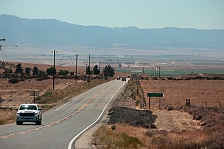
New Cuyama is a census-designated place in the Cuyama Valley, Santa Barbara County, California. It was named after the Chumash word for "clams", most likely due to the millions of petrified prehistoric clamshell fossils that are found in the surrounding areas. The town is home to the majority of the utility infrastructure for its residents, including nearby neighbor Cuyama, California. New Cuyama is located very close to the intersection points for Santa Barbara, San Luis Obispo, Ventura and Kern counties. The town is served by Highway 166 and the public-use New Cuyama Airport. The population was 542 at the 2020 census.

Rancho Asuncion was a 39,225-acre (158.74 km2) Mexican land grant in present-day San Luis Obispo County, California. It was given in 1845 by Governor Pío Pico to Pedro Estrada. The grant extended along the Salinas River in the Santa Lucia Range, and encompassed present-day Atascadero. Originally, Rancho de le Asuncion was part of the Mission San Miguel Arcángel territory and as such, was part of the Salinan Indian tribal territory.

<span class="mw-page-title-main">Garden Farms, California</span> Census-designated place in California, United States

Garden Farms is a census-designated place in San Luis Obispo County, California. Garden Farms sits at an elevation of 955 feet (291 m). The 2010 United States census reported Garden Farms's population was 386.

<span class="mw-page-title-main">Los Ranchos, California</span> Census-designated place in California, United States

Los Ranchos is a census-designated place in San Luis Obispo County, California. Los Ranchos sits at an elevation of 256 feet (78 m). The 2010 United States census reported Los Ranchos's population was 1,477.

<span class="mw-page-title-main">Cuesta Pass</span>

Cuesta Pass or La Cuesta Pass, colloquially referred to as simply the grade, is a low mountain pass in San Luis Obispo County on California's Central Coast. It crosses the southern Santa Lucia Range at an altitude of 1,522 feet (464 m), and connects San Luis Obispo, roughly 5 miles (8.0 km) to the south, with Atascadero, Paso Robles, and the Salinas Valley to the north. It is traversed by U.S. Route 101 and the Coast Line of the Union Pacific Railroad, and is better known for the long slope up to the pass from San Luis Obispo, in the canyon of San Luis Obispo Creek, which is redundantly named the "Cuesta Grade".

References

  1. U.S. Census Archived 2012-01-25 at the Wayback Machine
  2. 1 2 U.S. Geological Survey Geographic Names Information System: Santa Margarita, California
  3. Roe, Cheri (27 June 2016). Images of America: Santa Margarita. California: Arcadia Publishing. ISBN   9781467133746.
  4. Santa Margarita: A tiny town with a big community, Sanluisobispo.com, August 19, 2014.
  5. Town history, SantaMargaritaHistoricalSociety.org. Accessed November 6, 2022.
  6. "2010 Census Interactive Population Search: CA - Santa Margarita CDP". U.S. Census Bureau. Archived from the original on July 15, 2014. Retrieved July 12, 2014.

Further reading