Baywood-Los Osos, California

Last updated

Baywood-Los Osos, California
San Luis Obispo County California Incorporated and Unincorporated areas Baywood-Los Osos Highlighted.svg
Location in San Luis Obispo County and the state of California
Coordinates: 35°19′0″N120°50′8″W / 35.31667°N 120.83556°W / 35.31667; -120.83556
Country Flag of the United States (23px).png  United States
State Flag of California.svg  California
County San Luis Obispo
Government
  Type County Government
Area
  Total19.7 km2 (7.6 sq mi)
  Land19.7 km2 (7.6 sq mi)
  Water0 km2 (0 sq mi)
Population
 (2000)
  Total14,351
  Density728.5/km2 (1,888.3/sq mi)
Time zone UTC-8 (Pacific (PST))
  Summer (DST) UTC-7 (PDT)
ZIP codes
93402, 93412
Area code 805
FIPS code 06-04541
GNIS feature ID 2407812

Baywood-Los Osos (locally known as Los Osos-Baywood Park) is an unincorporated community in western San Luis Obispo County, California. [1] The population was 14,351 in the 2000 census. It includes the communities of Los Osos, which is located near Morro Bay, Baywood Park, and the former community of Cuesta-by-the-Sea.

Contents

Geography and natural history

Baywood-Los Osos is located at 35°19′0″N120°50′8″W / 35.31667°N 120.83556°W / 35.31667; -120.83556 (35.316795, -120.835605). [2]

According to the United States Census Bureau, the CDP had a total area of 7.6 square miles (20 km2), of which, 7.6 square miles (20 km2) of it was land and 0.13% was water.

This locale was settled originally by Chumash peoples who developed habitation sites and exploited marine resources for food. [3]

Demographics

Historical population
CensusPop.Note
1970 3,487
1980 10,933213.5%
1990 14,37731.5%
2000 14,351−0.2%
source: [4]

Baywood-Los Osos was a census-designated place (CDP) through the 2000 census, but the CDP was abolished before the 2010 census. As of the census [5] of 2000, there were 14,351 persons, 5,892 households, and 3,876 families residing in the CDP. The population density was 1,883.5 inhabitants per square mile (727.2/km2). There were 6,214 housing units at an average density of 815.6 per square mile (314.9/km2). The racial makeup of the CDP was 88.27% White, 0.64% African American, 0.69% Native American, 4.56% Asian, 0.07% Pacific Islander, 2.49% from other races, and 3.28% from two or more races. Hispanic or Latino of any race were 9.00% of the population.

There were 5,892 households, out of which 27.9% had children under the age of 18 living with them, 52.9% were married couples living together, 9.6% had a female householder with no husband present, and 34.2% were non-families. 25.6% of all households were made up of individuals, and 12.2% had someone living alone who was 65 years of age or older. The average household size was 2.42 and the average family size was 2.91.

In the CDP, the population was spread out, with 21.6% under the age of 18, 7.6% from 18 to 24, 24.7% from 25 to 44, 27.1% from 45 to 64, and 19.0% who were 65 years of age or older. The median age was 43 years. For every 100 females, there were 92.3 males. For every 100 females age 18 and over, there were 88.2 males.

The median income for a household in the CDP was $46,558, and the median income for a family was $55,838. Males had a median income of $39,311 versus $31,450 for females. The per capita income for the CDP was $24,838. About 5.0% of families and 8.5% of the population were below the poverty line, including 8.4% of those under age 18 and 5.1% of those age 65 or over.

Signpost at 3rd and El Moro in Baywood Park, California Los Osos, Baywood Signpost.jpg
Signpost at 3rd and El Moro in Baywood Park, California

Politics

In the California State Legislature, Baywood-Los Osos is in the 17th Senate District , represented by Democrat John Laird, and in the 35th Assembly District , represented by Democrat Jasmeet Bains. [6]

In the United States House of Representatives, Baywood-Los Osos is in California's 24th congressional district , represented by Democrat Salud Carbajal. [7]

See also

Related Research Articles

<span class="mw-page-title-main">San Luis Obispo County, California</span> County in California, United States

San Luis Obispo County, officially the County of San Luis Obispo, is a county on the Central Coast of California. As of the 2020 census, the population was 282,424. The county seat is San Luis Obispo.

<span class="mw-page-title-main">Citrus, California</span> Census-designated place in California, United States

Citrus is a census-designated place (CDP) in Los Angeles County, California, United States. It is located in the San Gabriel Valley between Azusa to the north and west, Glendora to the east, and Covina to the south. The population was 10,866 at the 2010 census, up from 10,581 at the 2000 census. Citrus is named after Citrus Avenue, which passes through the community.

<span class="mw-page-title-main">East San Gabriel, California</span> Census-designated place in California, United States

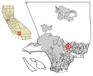
East San Gabriel is a census-designated place (CDP) in Los Angeles County, California, United States. The population was 14,874 at the 2010 census, up from 14,512 at the 2000 census.

<span class="mw-page-title-main">Bradley, California</span> Unincorporated community in California, United States

Bradley is an unincorporated community and census-designated place (CDP) in Monterey County, California, on the Salinas River 14 miles (23 km) south-southeast of San Ardo and 20 miles (32 km) north of Paso Robles. Bradley sits at an elevation of 548 feet (167 m). The population was 69 at the 2020 census, down from 93 at the 2010 census.

<span class="mw-page-title-main">Las Flores, California</span> Place in California, United States

Las Flores is an unincorporated census-designated place (CDP) in Orange County, California, located adjacent to the City of Rancho Santa Margarita, California. The population was 5,971 at the 2010 census, up from 5,625 at the 2000 census. Las Flores does not have its own ZIP Code and is served by the same ZIP Code as adjacent Rancho Santa Margarita, 92688. The Rancho Santa Margarita dog/skate park is located in the CDP and is served by the Orange County Sheriff's Dept. and Orange County Fire Authority. Although Las Flores lies in the land grant of Rancho Mission Viejo, it is named after the land grant about twenty-five miles (40 km) south Rancho Santa Margarita y Las Flores.

<span class="mw-page-title-main">Cayucos, California</span> Unincorporated community in California, United States

Cayucos is an unincorporated coastal town in San Luis Obispo County, California, along California State Route 1 between Cambria to the north and Morro Bay to the south. The population was 2,505 at the 2020 census, down from 2,592 at the 2010 census.

<span class="mw-page-title-main">Lake Nacimiento, California</span> Census-designated place in California, United States

Lake Nacimiento is a census-designated place (CDP) in northern San Luis Obispo County, California, United States.

<span class="mw-page-title-main">Morro Bay, California</span> City in California, United States

Morro Bay is a seaside city in San Luis Obispo County, California. Located on the Central Coast of California, the city population was 10,757 as of the 2020 census, up from 10,234 at the 2010 census. The town overlooks Morro Bay, a natural embayment with an all-weather small craft commercial and recreational harbor.

<span class="mw-page-title-main">Nipomo, California</span> Place in California, United States

Nipomo is an unincorporated town in San Luis Obispo County, California, United States. The population was 16,714 for the 2010 census and grew to 18,176 for the 2020 census. For statistical purposes, the United States Census Bureau has defined Nipomo as a census-designated place (CDP).

<span class="mw-page-title-main">Oceano, California</span> Census designated place in California, United States

Oceano is a census-designated place (CDP) in San Luis Obispo County, California, United States. The population was 7,183 at the 2020 census, down from 7,286 at the 2010 census.

<span class="mw-page-title-main">San Luis Obispo, California</span> City in California, United States

San Luis Obispo is a city and county seat of San Luis Obispo County, in the U.S. state of California. Located on the Central Coast of California, San Luis Obispo is roughly halfway between the San Francisco Bay Area in the north and Greater Los Angeles in the south. The population was 47,063 at the 2020 census.

<span class="mw-page-title-main">San Miguel, California</span> Place in California, United States

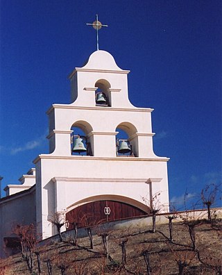
San Miguel is a unincorporated community in San Luis Obispo County, California, United States. As of the 2010 census, the population was 2,336. For statistical purposes, the United States Census Bureau has defined San Miguel as a census-designated place (CDP). San Miguel was founded by the Spanish in 1797, when Mission San Miguel Arcángel was established by Fermín de Lasuén. San Miguel is a tourist destination with historic architecture and vineyards, as part of the Paso Robles wine region.

<span class="mw-page-title-main">Shandon, California</span> Census-designated place in California, United States

Shandon is a village and census-designated place (CDP) in San Luis Obispo County, California, United States. The population was 1,295 at the 2010 census, up from 986 at the 2000 census. Shandon lies by the San Juan River.

<span class="mw-page-title-main">Templeton, California</span> Census-designated place in California, United States

Templeton is a census-designated place (CDP) in San Luis Obispo County, California, United States. The population was 7,674 at the 2010 census, up from 4,687 at the 2000 census.

<span class="mw-page-title-main">Highlands-Baywood Park, California</span> Unincorporated community in California, United States

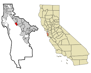
Highlands-Baywood Park is an unincorporated community in San Mateo County, California, United States. The population was 4,027 at the 2010 census. For statistical purposes, the United States Census Bureau has defined Highlands-Baywood Park as a census-designated place (CDP).

<span class="mw-page-title-main">Bystrom, California</span> Census-designated place in California, United States

Bystrom is a census-designated place (CDP) in Stanislaus County, California, United States. The population was 4,008 at the 2010 census, down from 4,518 at the 2000 census. It is part of the Modesto Metropolitan Statistical Area.

<span class="mw-page-title-main">East Oakdale, California</span> Census-designated place in California, United States

East Oakdale is an unincorporated census-designated place (CDP) on the Stanislaus River, located east of the city of Oakdale in Stanislaus County, California.

<span class="mw-page-title-main">East Sonora, California</span> Census-designated place in California, United States

East Sonora is a census-designated place (CDP) in Tuolumne County, California, United States. The population was 2,266 at the 2010 census, up from 2,078 at the 2000 census.

<span class="mw-page-title-main">Baywood, New York</span> Hamlet and census-designated place in New York, United States

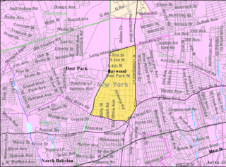
Baywood is a hamlet and census-designated place (CDP) in the Town of Islip in Suffolk County, on Long Island, in New York, United States. The population was 7,350 at the 2010 census.

<span class="mw-page-title-main">Los Osos, California</span> Unincorporated community in California, United States

Los Osos is an unincorporated town in San Luis Obispo County, California, United States. Located on the Central Coast of California, Los Osos had a population estimated to be 16,533 in 2019. For statistical purposes, the United States Census Bureau has defined Los Osos as a census-designated place (CDP).

References

Line notes

  1. San Luis Obispo County, California Planning Department. 1969
  2. "US Gazetteer files: 2010, 2000, and 1990". United States Census Bureau. February 12, 2011. Retrieved April 23, 2011.
  3. C. Michael Hogan. 2008
  4. "CENSUS OF POPULATION AND HOUSING (1790-2000)". U.S. Census Bureau . Retrieved July 31, 2010.
  5. "U.S. Census website". United States Census Bureau . Retrieved January 31, 2008.
  6. "Statewide Database". UC Regents. Archived from the original on February 1, 2015. Retrieved November 23, 2014.
  7. "California's 24th Congressional District - Representatives & District Map". Civic Impulse, LLC. Retrieved September 29, 2014.