Creston, California

Last updated

Creston
Creston Country Store.jpg
Creston Country Store, 2012
San Luis Obispo County California Incorporated and Unincorporated areas Creston Highlighted 0617232.svg
Location of Creston in San Luis Obispo County, California.
USA California location map.svg
Red pog.svg
Creston
Location within the state of California
Coordinates: 35°31′07″N120°31′26″W / 35.5187°N 120.5238°W / 35.5187; -120.5238 Coordinates: 35°31′07″N120°31′26″W / 35.5187°N 120.5238°W / 35.5187; -120.5238
Country United States
State California
County San Luis Obispo
Area
[1]
  Total0.57 sq mi (1.47 km2)
  Land0.56 sq mi (1.46 km2)
  Water0.01 sq mi (0.01 km2)  0.84%
Population
 (2020)
  Total98
  Density173.76/sq mi (67.11/km2)
Time zone UTC-8 (PST)
  Summer (DST) UTC-7 (PDT)
ZIP codes
93432
FIPS code 06-17232
Church of Spiritual Technology ranch (note logo, top center) near Creston, where L. Ron Hubbard spent his last days. Church of Spiritual Technology ranch Creston.jpg
Church of Spiritual Technology ranch (note logo, top center) near Creston, where L. Ron Hubbard spent his last days.

Creston is a census-designated place in San Luis Obispo County, California, about 10 miles east of Atascadero.

Contents

History

Creston (named after Calvin J. Cressy) was founded in 1884 on the Rancho Huerhuero Mexican land grant.

Creston was home to Cardiff Stud Farm (Creston Farms), a place once owned by Canadian-American television personality Alex Trebek, and where a number of retired American thoroughbred racehorses were taken care of, including those below. Cardiff Stud Farm was sold in 2008 and is now an event center called Windfall Farms. [2] An entity known as Cardiff Stud Farms still exists however, owned by Stephen Sahadi, but is situated in Atascadero, CA. [3] [4]

Notable retired racehorses who were stabled there include:

Writer and Scientology founder L. Ron Hubbard died at his ranch near Creston. [5]

In 2014, Creston was made an American Viticultural Area called the Creston District AVA. [6]

Transportation

Creston is near the following highways:

Demographics

Historical population
CensusPop.
2020 98
U.S. Decennial Census [7]

The 2010 United States Census [8] reported that Creston had a population of 94. The population density was 165.3 inhabitants per square mile (63.8/km2). The racial makeup of Creston was 89 (94.7%) White, 0 (0.0%) African American, 2 (2.1%) Native American, 1 (1.1%) Asian, 0 (0.0%) Pacific Islander, 0 (0.0%) from other races, and 2 (2.1%) from two or more races. Hispanic or Latino of any race were 6 persons (6.4%).

The Census reported that 94 people (100% of the population) lived in households, 0 (0%) lived in non-institutionalized group quarters, and 0 (0%) were institutionalized.

There were 36 households, out of which 15 (41.7%) had children under the age of 18 living in them, 20 (55.6%) were opposite-sex married couples living together, 3 (8.3%) had a female householder with no husband present, 3 (8.3%) had a male householder with no wife present. There were 3 (8.3%) unmarried opposite-sex partnerships, and 1 (2.8%) same-sex married couples or partnerships. 8 households (22.2%) were made up of individuals, and 2 (5.6%) had someone living alone who was 65 years of age or older. The average household size was 2.61. There were 26 families (72.2% of all households); the average family size was 2.96.

The population was spread out, with 22 people (23.4%) under the age of 18, 4 people (4.3%) aged 18 to 24, 28 people (29.8%) aged 25 to 44, 27 people (28.7%) aged 45 to 64, and 13 people (13.8%) who were 65 years of age or older. The median age was 39.0 years. For every 100 females, there were 80.8 males. For every 100 females age 18 and over, there were 80.0 males.

There were 39 housing units at an average density of 68.6 per square mile (26.5/km2), of which 27 (75.0%) were owner-occupied, and 9 (25.0%) were occupied by renters. The homeowner vacancy rate was 0%; the rental vacancy rate was 0%. 64 people (68.1% of the population) lived in owner-occupied housing units and 30 people (31.9%) lived in rental housing units.

Related Research Articles

San Luis Obispo County, California County in California, United States

San Luis Obispo County, officially the County of San Luis Obispo, is a county on the Central Coast of California. As of the 2020 census, the population was 282,424. The county seat is San Luis Obispo.

Arroyo Grande, California City in California, United States

Arroyo Grande is a city in San Luis Obispo County, California, United States. The population was 17,252 as of the 2010 Census.

Atascadero, California City in California, United States

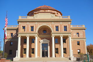
Atascadero is a city in San Luis Obispo County, California, about equidistant from Los Angeles and San Francisco on U.S. Route 101. Atascadero is part of the San Luis Obispo-Paso Robles metropolitan statistical area, which encompasses the extents of the county. Atascadero is farther inland than most other cities in the county, and as a result, usually experiences warmer, drier summers, and cooler winters than other nearby cities such as San Luis Obispo and Pismo Beach. The main freeway through town is U.S. 101. The nearby State Routes 41 and 46 provide access to the Pacific Coast and the Central Valley of California.

Cayucos, California Unincorporated community in California, United States

Cayucos is an unincorporated coastal town in San Luis Obispo County, California, along California State Route 1 between Cambria to the north and Morro Bay to the south. The population was 2,505 at the 2020 census, down from 2,592 at the 2010 census.

Grover Beach, California City in California, United States

Grover Beach is a city in San Luis Obispo County, California, United States. The population was 13,156 at the 2010 census, up from 13,067 in 2000. Grover Beach is the location of the Pacific Crossing cable Landing station. This is where trans-pacific submarine cables come ashore and interface with the North American telecom network.

San Luis Obispo, California City in California, United States

San Luis Obispo is a city and county seat of San Luis Obispo County, in the U.S. state of California. Located on the Central Coast of California, San Luis Obispo is roughly halfway between the Bay Area in the north and Greater Los Angeles in the south. The population was 47,063 at the 2020 census.

San Miguel, California Census-Designated Place in California, United States

San Miguel is a village and census-designated place (CDP) in San Luis Obispo County, California. As of the 2010 census, the population was 2,336. San Miguel was founded by the Spanish in 1797, when Mission San Miguel Arcángel was established by Fermín de Lasuén. Today, San Miguel is a popular tourist destination, owing to its historic architecture and its local vineyards, as part of the Paso Robles wine region.

Shandon, California Census-designated place in California, United States

Shandon is a village and census-designated place (CDP) in San Luis Obispo County, California, United States. The population was 1,295 at the 2010 census, up from 986 at the 2000 census. Shandon lies by the San Juan River.

Templeton, California Census-designated place in California, United States

Templeton is a census-designated place (CDP) in San Luis Obispo County, California. The population was 7,674 at the 2010 census, up from 4,687 at the 2000 census.

Graton, California Census-designated place in California, United States

Graton is an unincorporated town and census-designated place (CDP) in west Sonoma County, California, United States. The population was 1,707 at the 2010 census. Graton's ZIP code is 95444. The town also has a culinary reputation attributed to two restaurants in the area.

Avila Beach, California Place in California, United States

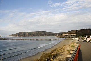
Avila Beach is an unincorporated community in San Luis Obispo County, California, United States, located on San Luis Obispo Bay about 160 miles (257 km) northwest of Los Angeles, and about 200 miles (320 km) south of San Francisco. The population was 1,576 at the 2010 census. For statistical purposes, the United States Census Bureau has defined Avila Beach as a census-designated place (CDP).

Potter Valley is a census-designated place in Mendocino County, California, United States. It is located 18 miles (29 km) north-northeast of Ukiah, at an elevation of 948 feet. It is located at the headwaters of the East Fork Russian River. The CDP population was 646 at the 2010 census.

Cuyama, California Census-designated place in California, United States

Cuyama is a census-designated place in Santa Barbara County. California. It is located in the Cuyama Valley, near the Carrizo Plain. The Cuyama River runs adjacent to the town, flowing west towards the Pacific Ocean. Cuyama is surrounded by many apricot, peach, and plum orchards. The ZIP Code is 93254, and the community is inside area code 805. The population was 57 at the 2010 census. The name "Cuyama" comes from an Indian village named Kuyam.

Santa Margarita, California Census-designated place in California, United States

Santa Margarita is a town and census-designated place located in San Luis Obispo County, California. It was founded in 1889 near Cuesta Peak and San Luis Obispo along State Route 58. The town's name comes from the Mexican Alta California land grant of Rancho Santa Margarita. It is home to the Santa Margarita de Cortona Asistencia site. The population was 1,259 at the 2010 census.

Callender, California Census-designated place in California, United States

Callender is a census-designated place in San Luis Obispo County, California, United States. Callender is located along California State Route 1 south of Arroyo Grande. The population was 1,262 at the 2010 census.

Paso Robles, California City in California, United States

Paso Robles, officially El Paso de Robles, is a city in San Luis Obispo County, California, United States. Located on the Salinas River north of San Luis Obispo, California, the city is known for its hot springs, its abundance of wineries, its production of olive oil, almond orchards, and for playing host to the California Mid-State Fair.

Blacklake, California Place in California, United States

Blacklake is a census-designated place in San Luis Obispo County, California. Blacklake sits at an elevation of 341 feet (104 m). The 2010 United States census reported Blacklake's population was 930.

Garden Farms, California Census-designated place in California, United States

Garden Farms is a census-designated place in San Luis Obispo County, California. Garden Farms sits at an elevation of 955 feet (291 m). The 2010 United States census reported Garden Farms's population was 386.

Los Ranchos, California Census-designated place in California, United States

Los Ranchos is a census-designated place in San Luis Obispo County, California. Los Ranchos sits at an elevation of 256 feet (78 m). The 2010 United States census reported Los Ranchos's population was 1,477.

Oak Shores is a census-designated place in northern San Luis Obispo County, central California.

References

  1. "2020 U.S. Gazetteer Files". United States Census Bureau. Retrieved October 30, 2021.
  2. "From The Horse's Mouth". Thoroughbred Info. 2008. Retrieved November 9, 2016.
  3. "Cardiff Stud Farms". Manta. July 24, 2018. Retrieved August 1, 2018.
  4. "Cardiff Stud Farms". Farm Ranch.
  5. Rigley, Colin (May 28, 2009). "L. Ron Hubbard's last refuge". New Times. San Luis Obispo, CA. Archived from the original on December 17, 2013. Retrieved November 9, 2016.
  6. "11 new viticultural areas established within Paso Robles". Paso Robles Daily News. October 8, 2014. Retrieved November 9, 2016.
  7. "Census of Population and Housing". Census.gov. Retrieved June 4, 2016.
  8. "2010 Census Interactive Population Search: CA – Creston CDP". U.S. Census Bureau. Archived from the original on July 15, 2014. Retrieved July 12, 2014.