California Valley, California

Last updated

California Valley
USA California location map.svg
Red pog.svg
California Valley
Location within the state of California
Usa edcp location map.svg
Red pog.svg
California Valley
California Valley (the United States)
Coordinates: 35°17′38″N119°58′16″W / 35.29389°N 119.97111°W / 35.29389; -119.97111
Country United States
State California
County San Luis Obispo
Area
  Total37.6 sq mi (97.5 km2)
Elevation
1,970 ft (600 m)
Population
 (2020)
  Total2,414
  Density64/sq mi (25/km2)
Time zone UTC-8 (Pacific (PST))
  Summer (DST) UTC-7 (PDT)
ZIP codes
93453
Area code 805/820

California Valley (Spanish: Valle de California) [1] [2] is an unincorporated community located in the eastern part of San Luis Obispo County, California, in the northern portion of the Carrizo Plain.

Contents

Geography

Wildflowers off Bitterwater Road, California Valley, March 2010. California Wildflowers off Bitterwater Rd 23Mar2010.jpg
Wildflowers off Bitterwater Road, California Valley, March 2010.
California Valley Cavalley05.jpg
California Valley

The zoned area of the valley is 24,083 acres (97.5 square kilometers) and it is approximately 1,970 feet (600 m) above sea level. The valley is very nearly flat, bordered to the west by mountains (part of the Los Padres National Forest) and to the east by a major fault, the San Andreas Fault (part of the Temblor Range). Immediately south of California Valley is Soda Lake, which is part of the Carrizo Plain National Monument.

Demographics

As of the 2020 Census, 2,414 people lived in California Valley with 1,206 total households. The racial makeup of was 2,293 (95%) White, 101 (4.2%) African American, 89 (3.7%) Native American, 89 (3.7%) from two or more races. Hispanic or Latino of any race were 172 persons (7.1%). [3] Households had a median income of $50,893 and 12.3% of households were below the poverty level. [4]

History

California Valley is believed to have been visited by Native Americans passing through to the sacred site at Painted Rock, but no permanent Indian settlement existed due to a lack of easily accessible water. California Valley was a Spanish land grant, the El Chicote Ranch, that was used for seasonal cattle raising.

Local newspaper archives suggest that outlaws hid in California Valley from time to time up until the 1930s. The Spanish land grant was parceled out in 1960 into over 7,200 2.5 acre (10,000 m2) sections by optimistic real estate developers. According to their own advertising fliers, these 1960 developers believed that the California State Water Project might bring water to the area. After a more northerly route (closer to Highway 41/46) for the State Water Project was selected, many buyers lost heart, many properties were abandoned and the developers went bankrupt. Several ranches and other developments built dirt or gravel airstrips and at least one paved runway was built and was at one time listed on aeronautical charts.

A few hundred people have built homes in this isolated area since, but the mass growth once promised never materialized. A Community Services District (CSD) was formed to deliver services to these residents, which includes trash collection, improvement of roads and the upkeep of a Community Center with a small public library.

Between 1960 and 2000, refuse and a number of old cars were dumped in the California Valley area, much of it by local residents, posing serious environmental issues. In 2006, a combined effort by the California Highway Patrol, California Department of Motor Vehicles, San Luis Obispo County Code Enforcement, and local businesses worked together to remove abandoned vehicles and accumulated trash.

Infrastructure

Aerial view northeast, with community center at lower right next to northern end of runway at right edge. Soda Lake Road is visible running diagonally up toward the left. The main community is about one mile (1.6 km) further south beyond the other end of the runway. Aerial-CAvalleyCommCtr.jpg
Aerial view northeast, with community center at lower right next to northern end of runway at right edge. Soda Lake Road is visible running diagonally up toward the left. The main community is about one mile (1.6 km) further south beyond the other end of the runway.

California Valley is located on Soda Lake Road about two miles (3 km) south of State Route 58. A small general store is closed, as well as the previously popular small restaurant. The community is served by a school and community center with library, open only on Wednesdays. Other than State Route 58 and Bitterwater Road, access is mainly through the Carrizo Plain via Soda Lake Road, which is a seasonal improved dirt road south of Soda Lake to State Route 33/State Route 166; or via smaller seasonal dirt roads to the east and south. No scheduled bus routes serve the community, and there are no rail lines.

Private airport

The private and restricted California Valley Airport Class II-C 4,200 ft (1,300 m) paved runway extends south from the community center but is not marked on current aeronautical charts and is painted at the south end with a white "X" indicating that it is closed although it can be used with advance permission.

Services

Community services are provided by the California Valley Community Service District (CSD). This includes road maintenance and limited trash service. The Community Center includes a fire station, small library, and community assembly hall. The address is 13084 Soda Lake Road, on the south side of Soda Lake Road, approximately 2 miles (3.2 km) south of Highway 58, in the village of California Valley.

Water, a porta-potty and a pay phone are available at the Community Center. The quality of the water is in dispute. Many California Valley residents consider the water potable, but signage to the contrary has been posted in the past.

Electricity is available in parts of California Valley. Telephone service is available through SBC. The local prefix is (805) 475-XXXX. There is strong analog mobile phone coverage and limited ("backscatter") GSM mobile phone coverage, as well as limited Nextel coverage. Verizon Wireless does have a sole tower which overlooks and covers a good portion of the valley.

The local zip code is 93453. Mail is delivered to drop boxes at the Community Center. Main roads (Belmont Trail, Soda Lake Road, Seven Mile Road) are paved to an extent. Others are packed dirt or decomposed granite. Other than the main roads, the only maintained roads are those with homes on them. Roads are frequently maintained only up to residential driveways.

Blue "No Services" signs are posted at major intersections leading into the California Valley area. No gas stations exist in the California Valley area. The nearest gasoline stations are in Taft/Maricopa, Atascadero/Santa Margarita, and on the outskirts of Paso Robles. This has led to stranded travelers on a number of occasions. Tow truck service is available but may be delayed for several hours.

Law enforcement is provided by the County Sheriff, but there is no local office or assigned unit. The California Highway Patrol infrequently patrols Highway 58. No medical services (doctors, clinics, hospitals) are available in the California Valley area. Fire and rescue services are provided by San Luis Obispo County Fire Station #42 located at the Community Center. The Station is staffed Tuesday through Thursday. Helicopter MEDEVAC service from Santa Maria and Bakersfield is available, weather permitting.

Schools

The local school is Carrisa Plains Elementary School, built in 1953, with about 46 students in attendance. The few high school students are bused to Atascadero, California, which had one of the last high school dormitories in California until the 1990s for their use. The nearest community college is in Taft. The nearest four-year university is California Polytechnic State University, San Luis Obispo

Nearby communities and services

The even smaller community of Simmler is about 3 miles (4.8 km) northeast along Highway 58. The Bureau of Land Management operates the Carrizo Plain National Monument Guy L. Goodwin Education Center about 12 miles (19 km) south on Soda Lake Road during limited hours for several months of the year.

Natural resources and climate

California Valley is on the Carrizo Plain, which is an arid grassland. Only limited drinkable groundwater is available. Nearby Soda Lake is an alkali lake and undrinkable. "The future development of California Valley is anticipated to be limited by water availability"—San Luis Obispo County General Plan. Alkaline soils hinder attempts at agricultural development.

Future development Planned development.jpg
Future development

The Carrizo Plain National Monument, administered by the United States Bureau of Land Management, was established to protect elements of native history and the undeveloped ecology of the southern part of the valley.

Industry and uses

Most residents are retirees or have other outside incomes. Neighboring ranches raise cattle. Some of the empty residential-zoned lands are used for illegal sheep grazing under contract with the Community Service District. Litigation brought upon the CSD by several residents resulted in the CSD banning grazing agreements and an undisclosed settlement amount. Other activities of interest in California Valley include an Indian sweat lodge, hot air ballooning, bird-watching, and astronomy, due to clear skies and no light pollution. In particular, Highway 58 is a popular route for car and motorcycle touring enthusiasts due to very low traffic and winding roads.

With the recent surge (and equally sudden decline) in oil prices, along with state emphasis on development of renewable energy sources, solar energy firms have studied California Valley and adjacent areas for siting possible solar power generating facilities. As the area is one of the sunniest in the United States, and competition from other economically self-sustaining land uses has been minimal, several such facilities are already under consideration. Two solar plants, California Valley Solar Ranch 250MW [5] (SunPower) and Topaz Solar Farm 550MW [6] (First Solar/MidAmerican) are under construction and already providing power to the state grid; another smaller plant, by Ausra, was purchased by First Solar and incorporated into Topaz Solar Farm. [7] The combined Ausra and OptiSolar projects make Topaz Solar Farm one of the largest photovoltaic power plants in the world. [8] The two projects, about 10 miles apart, also represent two of the largest solar power contracts for Pacific Gas & Electric Company, which is under state mandate to increase its supply of renewable electricity to 33 percent by 2020. [9]

See also

Related Research Articles

<span class="mw-page-title-main">San Luis Obispo County, California</span> County in California, United States

San Luis Obispo County, officially the County of San Luis Obispo, is a county on the Central Coast of California. As of the 2020 census, the population was 282,424. The county seat is San Luis Obispo.

<span class="mw-page-title-main">Atascadero, California</span> City in California, United States

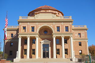
Atascadero is a city in San Luis Obispo County, California, United States, located on U.S. Route 101. Atascadero is part of the San Luis Obispo-Paso Robles metropolitan statistical area, which encompasses the extents of the county. Atascadero is farther inland than most other cities in the county, and as a result, usually experiences warmer, drier summers, and cooler winters than other nearby cities such as San Luis Obispo and Pismo Beach. The main freeway through town is U.S. 101. The nearby State Routes 41 and 46 provide access to the Pacific Coast and the Central Valley of California.

<span class="mw-page-title-main">San Luis Obispo, California</span> City in California, United States

San Luis Obispo is a city and county seat of San Luis Obispo County, in the U.S. state of California. Located on the Central Coast of California, San Luis Obispo is roughly halfway between the San Francisco Bay Area in the north and Greater Los Angeles in the south. The population was 47,063 at the 2020 census.

<span class="mw-page-title-main">Central Coast (California)</span> Region of California in the United States

The Central Coast is an area of California, roughly spanning the coastal region between Point Mugu and Monterey Bay. It lies northwest of Los Angeles and south of the San Francisco Bay Area, and includes the rugged, rural, and sparsely populated stretch of coastline known as Big Sur.

<span class="mw-page-title-main">California State Route 46</span> Highway in California

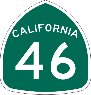
State Route 46 is an east–west state highway in the U.S. state of California. It is a major crossing of the Coast Ranges and it is the southernmost crossing of the Diablo Range, connecting SR 1 on the Central Coast near Cambria and US 101 in Paso Robles with SR 99 at Famoso in the San Joaquin Valley.

The State Scenic Highway System in the U.S. state of California is a list of highways, mainly state highways, that have been designated by the California Department of Transportation (Caltrans) as scenic highways. They are marked by the state flower, a California poppy, inside either a rectangle for state-maintained highways or a pentagon for county highways.

<span class="mw-page-title-main">Carrizo Plain</span> Grassland area in San Luis Obispo County, California

The Carrizo Plain is a large enclosed grassland plain, approximately 50 miles (80 km) long and up to 15 miles (24 km) across, in southeastern San Luis Obispo County, California, United States, about 100 miles (160 km) northwest of Los Angeles. The southern portion of the Carrizo Plain is within the 246,812-acre (99,881 ha) Carrizo Plain National Monument, which also includes most of the Caliente Range. The Carrizo Plain is the largest single native grassland remaining in California. It includes Painted Rock in the Carrizo Plain Rock Art Discontiguous District, which is listed on the National Register of Historic Places. In 2012 it was further designated a National Historic Landmark due to its archeological value. The San Andreas Fault occurs along the eastern edge of the Carrizo Plain at the western base of the Temblor Range.

<span class="mw-page-title-main">California State Route 41</span> Highway in California

State Route 41 is a state highway in the U.S. State of California, connecting the Central Coast with the San Joaquin Valley and the Sierra Nevada. Its southern terminus is at the Cabrillo Highway in Morro Bay, and its northern terminus is at SR 140 in Yosemite National Park. It has been constructed as an expressway from near SR 198 in Lemoore north to the south part of Fresno, where the Yosemite Freeway begins, passing along the east side of downtown and extending north into Madera County.

<span class="mw-page-title-main">Temblor Range</span> Mountain range in the southern California Coastal Ranges

The Temblor Range is a mountain range within the California Coast Ranges, at the southwestern extremity of the San Joaquin Valley in California in the United States. It runs in a northwest-southeasterly direction along the borders of Kern County and San Luis Obispo County. The name of the range is from Spanish temblor meaning "tremor", referring to earthquakes. The San Andreas Fault Zone runs parallel to the range at the base of its western slope, on the eastern side of the Carrizo Plain, while the Antelope Plain, location of the enormous Midway Sunset, South Belridge, and Cymric oil fields, lies to the northeast.

California's 19th congressional district is a congressional district in the U.S. state of California, currently represented by Democrat Jimmy Panetta.

<span class="mw-page-title-main">Soda Lake (San Luis Obispo County)</span> Alkali lake in California, US

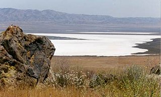
Soda Lake is a shallow, ephemeral, alkali endorheic lake in the Carrizo Plain in southeastern San Luis Obispo County, California. The lake is located on the southwest side of the northern Carrizo Plain, 103 km (64 mi) east of San Luis Obispo. It can be reached by Soda Lake Road, which runs northwest–southeast between State Route 166 and State Route 58. The lake is at an elevation of 580 m (1,900 ft) and covers an area of about 12 km2 (4.6 sq mi).

The Carrizo Energy Solar Farm was a proposed 177 megawatt (MW) solar thermal power plant, to be built by Ausra in California's Carrizo Plain, near Simmler. The location gets less sun than the Mojave Desert, where several other solar thermal plants are under consideration, but is near an existing transmission line from Diablo Canyon Power Plant, reducing the cost and time needed to construct the plant.

Tierra Redonda Mountain is a mountain in northwestern San Luis Obispo County, California. It is in the eastern portion of the Santa Lucia Range, separated from the main ridge by the Nacimiento River.

<span class="mw-page-title-main">Cuyama Valley</span> Valley along the Cuyama river in California

The Cuyama Valley is a valley along the Cuyama River in central California, in northern Santa Barbara, southern San Luis Obispo, southwestern Kern, and northwestern Ventura counties. It is about two hours driving time from both Los Angeles and the Santa Barbara area.

<span class="mw-page-title-main">Topaz Solar Farm</span>

Topaz Solar Farm is a 550 megawatt (MWAC) photovoltaic power station in San Luis Obispo County, California, United States. Construction on the project began in November 2011 and ended in November 2014. It is one of the world's largest solar farms. The $2.5 billion project includes 9 million CdTe photovoltaic modules based on thin-film technology, manufactured by U.S. company First Solar. The company also built, operates and maintains the project for MidAmerican Renewables, a Berkshire Hathaway company. Pacific Gas and Electric will buy the electricity under a 25-year power purchase agreement. According to First Solar, it created about 400 construction jobs.

<span class="mw-page-title-main">California Valley Solar Ranch</span> Photovoltaic power plant in the Carrizo Plain, northeast of California Valley.

The California Valley Solar Ranch (CVSR) is a 250 megawatt (MWAC) photovoltaic power plant in the Carrizo Plain, northeast of California Valley. The project is owned by NRG Energy, and SunPower is the EPC contractor and technology provider. The project constructed on 1,966 acres (796 ha) of a 4,365-acre (1,766 ha) site of former grazing land. It is utilizing high-efficiency, crystalline PV panels designed and manufactured by SunPower. The project includes up to 88,000 SunPower solar tracking devices to hold PV panels that track the sun across the sky.

<span class="mw-page-title-main">Painted Rock (San Luis Obispo County, California)</span>

Painted Rock is a smooth horseshoe-shaped marine sandstone rock formation with pictograph rock art about 250 feet across and 45 feet tall near Soda Lake within the Carrizo Plain National Monument on the southwest side of the northern Carrizo Plain, west of Bakersfield and about 70 miles (110 km) east of San Luis Obispo and 45 miles (72 km) west of Taft, in California, United States.

<span class="mw-page-title-main">California Valley Airport</span> Airport

California Valley Airport was a privately owned restricted-use airport located adjacent to the community center of California Valley, in the sparsely populated Carrizo Plain of San Luis Obispo County, California, United States.

<span class="mw-page-title-main">Land Conservancy of San Luis Obispo County</span> Nonprofit organization in California

The Land Conservancy of San Luis Obispo County (LCSLO) is a non-profit land trust organization that has been operating in San Luis Obispo County, California since 1984. The LCSLO is dedicated to the voluntary and collaborative preservation and improvement of lands that hold significant scenic, agricultural, habitat, and cultural values. Their work aims to benefit both the local community and wildlife that depends on these lands.

Chico Martinez Creek, formerly Arroyo Chico Martinez is a stream with its source located in the Temblor Range in Kern County, California near to the San Luis Obispo County boundary. Its source is located 10.7 miles north of Soda Lake, California in the middle of the Carrizo Plain. The creek runs generally east and northeast to terminate just east of the South Belridge Oil Field. In years of heavy rainfall it may have been a tributary to the Kern River between Buena Vista Lake and Tulare Lake.

References

  1. San Luis Obispo Unified School District - 2019 Spanish Spring Community Report
  2. El Ágora - California: el granero de EEUU necesita agua
  3. "Explore Census Data". data.census.gov. Retrieved March 16, 2023.
  4. "Explore Census Data". data.census.gov. Retrieved March 16, 2023.
  5. "Solarance".
  6. "550MW (AC) Topaz Solar Farm | First Solar". Archived from the original on January 6, 2013.
  7. "First Solar buys Ausra project in the Carrizo".
  8. "Topaz Solar Farm". Forbes .
  9. "News Archives - Renewable Energy World". May 23, 2023.