Related Research Articles

The Midwestern United States, also referred to as the Midwest or the American Midwest, is one of four census regions of the United States Census Bureau. It occupies the northern central part of the United States. It was officially named the North Central Region by the U.S. Census Bureau until 1984. It is between the Northeastern United States and the Western United States, with Canada to the north and the Southern United States to the south.

The breadbasket of a country or of a region is an area which, because of the richness of the soil and/or advantageous climate, produces large quantities of wheat or other grain. Rice bowl is a similar term used to refer to Southeast Asia; California's Salinas Valley is sometimes referred to as America's salad bowl. Such regions may be the subject of fierce political disputes, which may even escalate into full military conflicts.
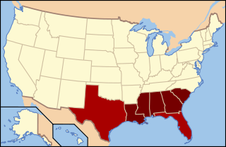
The Deep South or the Lower South is a cultural and geographic subregion of the Southern United States. The term was first used to describe the states which were most economically dependent on plantations and slavery. After the American Civil War ended in 1865, the region suffered economic hardship and was a major site of racial tension during and after the Reconstruction era. Before 1945, the Deep South was often referred to as the "Cotton States" since cotton was the primary cash crop for economic production. The civil rights movement in the 1950s and 1960s helped usher in a new era, sometimes referred to as the New South. The Deep South is part of the highly-religious, socially conservative Bible Belt and is currently a Republican Party stronghold.
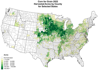
The Corn Belt is a region of the Midwestern United States and part of the Southern United States that, since the 1850s, has dominated corn production in the United States. In North America, corn is the common word for maize. More generally, the concept of the Corn Belt connotes the area of the Midwest dominated by farming and agriculture, though it stretches down into the South as well reaching into Kentucky.
Black Belt is a physical geography term referring to a roughly crescent-shaped geological formation of dark fertile soil in the Southern United States. It is about 300 miles (480 km) long and up to 25 miles (40 km) wide in c. east–west orientation, mostly in central Alabama and northeast Mississippi.
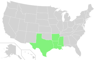
The Rice Belt of the United States includes Arkansas, Louisiana, Mississippi and Texas, four southern U.S. states that grow a significant portion of the nation's rice crop. The name is in conformity with the Corn Belt of the Midwestern United States, in which much of the nation's corn is grown.

The history of agriculture in the United States covers the period from the first English settlers to the present day. In Colonial America, agriculture was the primary livelihood for 90% of the population, and most towns were shipping points for the export of agricultural products. Most farms were geared toward subsistence production for family use. The rapid growth of population and the expansion of the frontier opened up large numbers of new farms, and clearing the land was a major preoccupation of farmers. After 1800, cotton became the chief crop in southern plantations, and the chief American export. After 1840, industrialization and urbanization opened up lucrative domestic markets. The number of farms grew from 1.4 million in 1850, to 4.0 million in 1880, and 6.4 million in 1910; then started to fall, dropping to 5.6 million in 1950 and 2.2 million in 2008.

The Mormon corridor are the areas of western North America that were settled between 1850 and approximately 1890 by members of the Church of Jesus Christ of Latter-day Saints, who are commonly called "Mormons".
The Intermountain West, or Intermountain Region, is a geographic and geological region of the Western United States. It is located between the Rocky Mountain Front on the east and the Cascade Range and Sierra Nevada on the west.
Agriculture in Central Asia provides a brief regional overview of agriculture in the five contiguous states of former Soviet Central Asia – Kazakhstan, Kyrgyzstan, Tajikistan, Turkmenistan, and Uzbekistan. Two other countries that are sometimes classified as Central Asian – Afghanistan and Mongolia – are included in this overview because of their substantially different background.

The Upland South and Upper South are two overlapping cultural and geographic subregions in the inland part of the Southern United States. They differ from the Deep South and Atlantic coastal plain by terrain, history, economics, demographics, and settlement patterns.

Central Illinois is a region of the U.S. state of Illinois that consists of the entire central third of the state, divided from north to south. Also known as the Heart of Illinois, it is characterized by small towns and mid-sized cities. Agriculture, particularly corn and soybeans, as well as educational institutions and manufacturing centers, figure prominently.
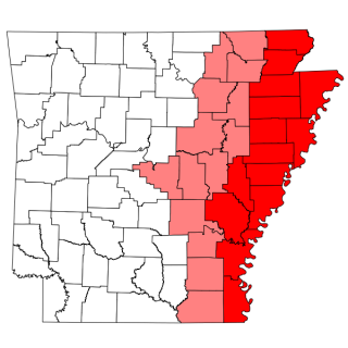
The Arkansas Delta is one of the six natural regions of the state of Arkansas. Willard B. Gatewood Jr., author of The Arkansas Delta: Land of Paradox, says that rich cotton lands of the Arkansas Delta make that area "The Deepest of the Deep South."

The Cotton Belt is a region of the Southern United States where cotton was the predominant cash crop from the late 18th century into the 20th century.
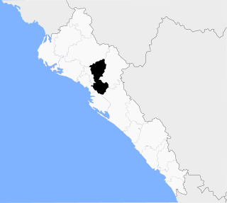
Municipality of Mocorito is a municipality in the Mexican state of Sinaloa in northwestern Mexico. It is bordered to the north by the municipality of Sinaloa, to the south by Navolato, to the southeast by Culiacán, to the east by Badiraguato and to the west with Salvador Alvarado and Angostura. It encompasses a total of 2,800.6 km² and represents 4.9% of the territory of Sinaloa. According to the 2020 census it had a population of 40,358, compromising 270 total localities. Major localities include Pericos, Mocorito, and Caimanero.

Farming systems in India are strategically utilized, according to the locations where they are most suitable. The farming systems that significantly contribute to the agriculture of India are subsistence farming, organic farming, industrial farming. Regions throughout India differ in types of farming they use; some are based on horticulture, ley farming, agroforestry, and many more. Due to India's geographical location, certain parts experience different climates, thus affecting each region's agricultural productivity differently. India is very dependent on its monsoon cycle for large crop yields. India's agriculture has an extensive background which goes back to at least 9 thousand years. In India, in the alluvial plains of the Indus River in Pakistan, the old cities of Mohenjo-Daro and Harappa experienced an apparent establishment of an organized farming urban culture. That society, known as the Harappan or Indus civilization, flourished until shortly after 4000 BP; it was much more comprehensive than those of Egypt or Babylonia and appeared earlier than analogous societies in northern China. Currently, the country holds the second position in agricultural production in the world. In 2007, agriculture and other industries made up more than 16% of India's GDP. Despite the steady decline in agriculture's contribution to the country's GDP, agriculture is the biggest industry in the country and plays a key role in the socio-economic growth of the country. India is the second-largest producer of wheat, rice, cotton, sugarcane, silk, groundnuts, and dozens more. It is also the second biggest harvester of vegetables and fruit, representing 8.6% and 10.9% of overall production, respectively. The major fruits produced by India are mangoes, papayas, sapota, and bananas. India also has the biggest number of livestock in the world, holding 281 million. In 2008, the country housed the second largest number of cattle in the world with 175 million.
Agriculture in the Southwest United States is very important economically in that region.
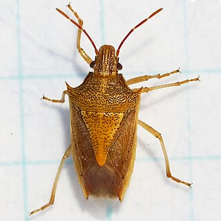
Oebalus pugnax, the rice stink bug, is a flying insect in the shield bug family Pentatomidae native to North America that has become a major agricultural pest in the Southern United States. It has been a known pest since at least the time of Johan Christian Fabricius, who described the species in 1775.

Agriculture in Mexico has been an important sector of the country’s economy historically and politically even though it now accounts for a very small percentage of Mexico’s GDP. Mexico is one of the cradles of agriculture with the Mesoamericans developing domesticated plants such as maize, beans, tomatoes, squash, cotton, vanilla, avocados, cacao, various kinds of spices, and more. Domestic turkeys and Muscovy ducks were the only domesticated fowl in the pre-Hispanic period and small dogs were raised for food. There were no large domesticated animals.
The Mississippi Alluvial Plain is a Level III ecoregion designated by the Environmental Protection Agency (EPA) in seven U.S. states, though predominantly in Arkansas, Louisiana, and Mississippi. It parallels the Mississippi River from the Midwestern United States to the Gulf of Mexico.
References
- ↑ "Wheat Belt Region, North America", Encyclopædia Britannica, retrieved 21 July 2016
- 1 2 3 Gal, Mark Abadi, Shayanne. "The US is split into more than a dozen 'belts' defined by industry, weather, and even health". Business Insider. Retrieved 8 July 2020.
{{cite web}}: CS1 maint: multiple names: authors list (link) - ↑ "Cotton Belt | agricultural region, United States". Encyclopedia Britannica. Retrieved 8 July 2020.
- ↑ Skelley, Geoffrey (25 June 2020). "New Polling Shows Trump's Electoral College Advantage Is Slipping". FiveThirtyEight. Retrieved 8 July 2020.
- ↑ "Where Is The Rice Belt? Rice Belt States". WorldAtlas. 28 January 2019. Retrieved 8 July 2020.