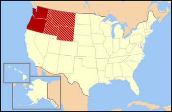
The Pacific Northwest (PNW), sometimes referred to as Cascadia, is a geographic region in western North America bounded by its coastal waters of the Pacific Ocean to the west and, loosely, by the Rocky Mountains to the east. Though no official boundary exists, the most common conception includes the U.S. states of Oregon, Washington, northern Idaho, and the Canadian province of British Columbia. Some broader conceptions reach north into Alaska and Yukon, south into northern California, and east into western Montana. Other conceptions may be limited to the coastal areas west of the Cascade and Coast mountains.
The Western United States, also called the American West, the Western States, the Far West, and the West, is the region comprising the westernmost U.S. states. As American settlement in the U.S. expanded westward, the meaning of the term the West changed. Before around 1800, the crest of the Appalachian Mountains was seen as the western frontier. The frontier moved westward and eventually the lands west of the Mississippi River were considered the West.

The Pacific Coast Ranges are the series of mountain ranges that stretch along the West Coast of North America from Alaska south to Northern and Central Mexico. Although they are commonly thought to be the westernmost mountain range of the continental United States and Canada, the geologically distinct Insular Mountains of Vancouver Island lie farther west.
The Territory of Oregon was an organized incorporated territory of the United States that existed from August 14, 1848, until February 14, 1859, when the southwestern portion of the territory was admitted to the Union as the State of Oregon. Originally claimed by several countries, Spanish "El Orejón" was part of the Territorio de Nutca (1789–1795), later in the 19th century, the region was divided between the British Empire and the US in 1846. When established, the territory encompassed an area that included the current states of Oregon, Washington, and Idaho, as well as parts of Wyoming and Montana. The capital of the territory was first Oregon City, then Salem, followed briefly by Corvallis, then back to Salem, which became the state capital upon Oregon's admission to the Union.
The Territory of Washington was an organized incorporated territory of the United States that existed from March 2, 1853, until November 11, 1889, when the territory was admitted to the Union as the State of Washington. It was created from the portion of the Oregon Territory north of the lower Columbia River and north of the 46th parallel east of the Columbia. At its largest extent, it also included the entirety of modern Idaho and parts of Montana and Wyoming, before attaining its final boundaries in 1863.

The Territory of Wyoming was an organized incorporated territory of the United States that existed from July 25, 1868, until July 10, 1890, when it was admitted to the Union as the State of Wyoming. Cheyenne was the territorial capital. The boundaries of the Wyoming Territory were identical to those of the modern State of Wyoming.

The Territory of Idaho was an organized incorporated territory of the United States that existed from March 3, 1863, until July 3, 1890, when the final extent of the territory was admitted to the Union as Idaho.

The territory of the United States and its overseas possessions has evolved over time, from the colonial era to the present day. It includes formally organized territories, proposed and failed states, unrecognized breakaway states, international and interstate purchases, cessions, and land grants, and historical military departments and administrative districts. The last section lists informal regions from American vernacular geography known by popular nicknames and linked by geographical, cultural, or economic similarities, some of which are still in use today.

North Central Idaho is an area which spans the central part of the state of Idaho and borders Oregon, Montana, and Washington. It is the southern half of the state's Panhandle region and is rich in agriculture and natural resources. Lewis and Clark traveled through this area on their journey to the Pacific Ocean in September 1805, crossing Lolo Pass and continuing westward in canoes on the Clearwater River. They returned the following spring on their way eastward.

The Northwest Territorial Imperative was a white separatist idea put forward in the 1970s–80s by white nationalist, white supremacist, white separatist and neo-Nazi groups within the United States. According to it, members of these groups were encouraged to relocate to a region of the Northwestern United States—Washington, Oregon, Idaho, and Western Montana—with the intention to eventually turn the region into an Aryan ethnostate. Some definitions of the project include the entire states of Montana and Wyoming, plus Northern California.

Lincoln is the name for several proposals to create a new state in the Northwest United States. The proposed State has been defined in multiple ways, but can generally be said to be coterminous with the region known as the Inland Northwest. The proposed state was named in honor of Abraham Lincoln, who was president during the American Civil War. His name had also been proposed for the states that were eventually named North Dakota and Wyoming.

The North American Cordillera, sometimes also called the Western Cordillera of North America, the Western Cordillera, or the Pacific Cordillera, is the North American portion of the American Cordillera, the mountain chain system (cordillera) along the western coast of the Americas. The North American Cordillera covers an extensive area of mountain ranges, intermontane basins, and plateaus in Western and Northwestern Canada, Western United States, and Mexico, including much of the territory west of the Great Plains.
Qwest Corporation is a Regional Bell Operating Company owned by Lumen Technologies. It was formerly named U S WEST Communications, Inc. from 1991 to 2000, and also formerly named Mountain States Telephone and Telegraph Company, known as Mountain Bell from 1911 to 1991. It includes the former operations of Malheur Bell, Northwestern Bell and Pacific Northwest Bell as well.

The Unitarian Universalist Association, an association of Unitarian Universalist Congregations in the United States of America, is composed of 19 Districts.

The concept of Cascadian bioregionalism is closely identified with the environmental movement. In the early 1970s, the contemporary vision of bioregionalism began to be formed through collaboration between natural scientists, social and environmental activists, artists and writers, community leaders, and back-to-the-landers who worked directly with natural resources. A bioregion is defined in terms of the unique overall pattern of natural characteristics that are found in a specific place. The main features are generally obvious throughout a continuous geographic terrain and include a particular climate, local aspects of seasons, landforms, watersheds, soils, and native plants and animals. People are also counted as an integral aspect of a locale's life, as can be seen in the ecologically adaptive cultures of early inhabitants, and in the activities of present-day reinhabitants who attempt to harmonize in a sustainable way with the place where they live.
The National Park Service (NPS) in the United States is a Bureau of the Department of the Interior with its headquarters located in Washington, D.C. The bureaus consist of numerous support offices and seven regional offices, which oversee park operations within their geographic area. The NPS has 3 main offices/verticals that support the Office of the Director: The Office of Congressional & External Relations, The Office of Management & Administration, and Operations.

The 1763 Treaty of Paris ended the major war known by Americans as the French and Indian War and by Canadians as the Seven Years' War / Guerre de Sept Ans, or by French-Canadians, La Guerre de la Conquête. It was signed by Great Britain, France and Spain, with Portugal in agreement. Preferring to keep Guadeloupe, France gave up Canada and all of its claims to territory east of the Mississippi River to Britain. With France out of North America this dramatically changed the European political scene on the continent.

The Mountain states form one of the nine geographic divisions of the United States that are officially recognized by the United States Census Bureau. It is a subregion of the Western United States.