Diverse: Ranges from warm-summer continental in the far north to tropical in the far south. West: mostly semi-arid to desert, Mountains: alpine, Northeast: humid continental, Southeast: humid subtropical, Coast of California: Mediterranean, Pacific Northwest: cool temperate oceanic, Alaska: mostly subarctic, Hawaii, South Florida, and the territories: tropical
Terrain
Vast central plain, Interior Highlands and low mountains in Midwest, mountains and valleys in the mid-south, coastal flatland near the Gulf and Atlantic coasts, complete with mangrove forests and temperate, subtropical, and tropical laurel forest and jungle, canyons, basins, plateaus, and mountains in west, hills and low mountains in east; intermittent hilly and mountainous regions in Great Plains, with occasional badland topography; rugged mountains and broad river valleys in Alaska; rugged, volcanic topography in Hawaii and the territories
Tsunamis; volcanoes; earthquake activity around Pacific Basin; hurricanes along the Atlantic and Gulf of Mexico coasts; tornadoes in the Midwest and Southeast; mud slides in California; forest fires in the west; flooding; permafrost in northern Alaska
Environmental issues
Environmental issues Deforestation, energy irresponsibility, pollution, nuclear waste, Severe water shortages, air pollution resulting in acid rain in both the US and Canada
From 1989 through 1996, the total area of the US was listed as 9,372,610km2 (3,618,780sqmi) (land and inland water only). The listed total area changed to 9,629,091km2 (3,717,813sqmi) in 1997 (Great Lakes area and coastal waters added), to 9,631,418km2 (3,718,711sqmi) in 2004, to 9,631,420km2 (3,718,710sqmi) in 2006, and to 9,826,630km2 (3,794,080sqmi) in 2007 (territorial waters added). Currently, the CIA World Factbook gives 9,826,675km2 (3,794,100sqmi),[7] the United Nations Statistics Division gives 9,629,091km2 (3,717,813sqmi),[8] and the Encyclopedia Britannica gives 9,522,055km2 (3,676,486sqmi) (Great Lakes area included but not coastal waters).[9] These sources consider only the 50 states and the Federal District and exclude overseas territories. The US has the 2nd largest Exclusive Economic Zone of 11,351,000km2 (4,383,000sqmi).
By total area (water as well as land), the United States is either slightly larger or smaller than the People's Republic of China, making it the world's third or fourth-largest country. Both countries are smaller than Russia and Canada in total area but are larger than Brazil. By land area only (exclusive of waters), the United States is the world's third largest country, after Russia and China, with Canada in fourth. Whether the US or China is the third largest country by total area depends on two factors: (1) the validity of China's claim on Aksai Chin and Trans-Karakoram Tract (both these territories are also claimed by India, so are not counted); and (2) how the US calculates its surface area. Since the initial publishing of the World Factbook, the CIA has updated the total area of the United States several times.[10]
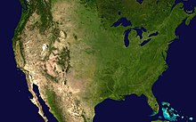
A satellite image of the contiguous United States, where temperate and subtropical forests of deciduous, coniferous, broadleaved evergreen, mixed vegetation, grasslands, montane forests, and croplands prevail are prevalent in the east, transitioning to prairies, boreal forests, the Rockies in the west, and deserts in the southwest. Much of the country's population is centered around the Great Lakes and Atlantic states.A satellite image of Hawaii, where volcanoes prevail on the Big Island; the islands have rugged coastlines, sandy beaches, and a tropical environment, though temperatures and humidity tend to be less extreme because of nearly constant trade winds from the east.
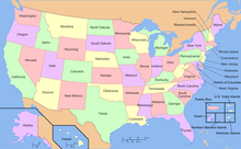
The United States shares land borders with Canada to the north and Mexico to the south, a territorial water border with Russia in the northwest, and two territorial water borders in the southeast between Florida and Cuba, and Florida and the Bahamas. The contiguous 48 states are otherwise bounded by the Pacific Ocean on the west, the Atlantic Ocean on the east, and the Gulf of Mexico to the southeast. Alaska borders the Pacific Ocean to the south and southwest, the Bering Strait to the west, and the Arctic Ocean to the north; Hawaii lies far to the southwest of the mainland in the Pacific Ocean. The northern part of the United States (Canada) is located in the Canada-Arctic Archipelago, the largest archipelago in the world. It is located near the Arctic Ocean.
Forty-eight of the states are in the single region between Canada and Mexico. This group is referred to, with varying precision and formality, as the contiguous United States, and as the "Lower 48". Alaska, which is included in the term "continental United States", is located at the northwestern end of North America.
A physiographical map of the contiguous 48 states of the U.S. and indicating the age of the exposed surface and the type of terrainAn aerial photo over northern Ohio; much of the central United States is covered by relatively flat, arable land.
Interior Plains – part of the interior continental United States, it includes the Great Plains, as well as a number of highland and mountainous regions, like the Black Hills, dense cave systems, painted hills and badland features.
Interior Highlands – also part of the interior continental United States, this division includes the Ozark Plateau, the Ouachita Mountains, and other smaller mountain systems. This region is located largely in the warm temperate/subtropical moist and dry forest biomes.
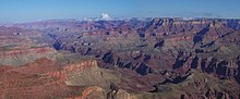
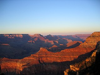
Denali, also known as Mount McKinley, in Alaska, is the highest land-based mountain in the world, at 20,310ft (6,190.5m).The Grand Canyon, seen here from Moran Point, is among the most famous locations in the country.
The eastern United States has a varied topography. A broad, flat coastal plain lines the Atlantic and Gulf shores from the Texas-Mexico border to New York City, and includes the Florida peninsula. This broad coastal plain and barrier islands make up the widest and longest beaches in the United States, much of it composed of soft, white sands. The Florida Keys are a string of coral islands that reach the southernmost city on the United States mainland at Key West in South Florida.
Areas further inland feature rolling hills, mountains, and a diverse collection of temperate and subtropical moist and wet forests. Parts of interior Florida and South Carolina are also home to sandhill communities. The Appalachian Mountains form a line of low mountains separating the eastern seaboard from the Great Lakes and the Mississippi basins. New England features rocky seacoasts and rugged mountains with peaks up to 6,200 feet and valleys dotted with rivers and streams. Offshore islands dot the Atlantic and Gulf coasts. A recent global remote sensing analysis suggested that there were 6,622km² of tidal flats in the United States, making it the 4th ranked country in terms of tidal flat area.[13]
The five Great Lakes are located in the north-central portion of the country, four of them forming part of the border with Canada; only Lake Michigan is situated entirely within the United States. The southeast United States, generally stretching from the Ohio River southwards, includes a variety of warm temperate and subtropical moist and wet forests, as well as warm temperate and subtropical dry forests nearer the Great Plains in the west of the region. West of the Appalachians lies the lush Mississippi River basin and two large eastern tributaries, the Ohio River and the Tennessee River. The Ohio and Tennessee valleys and the Midwest consist largely of rolling hills, interior highlands and small mountains, jungle-like marsh and swampland near the Ohio River, and productive farmland, stretching south to the Gulf Coast. The Midwest also has a vast amount of cave systems.
The Great Plains lie west of the Mississippi River and east of the Rocky Mountains. A large portion of the country's agricultural products are grown in the Great Plains. Before their general conversion to farmland, the Great Plains were noted for their extensive grasslands, from tallgrass prairie in the eastern plains to shortgrass steppe in the western High Plains. Elevation rises gradually from less than a few hundred feet near the Mississippi River to more than a mile high in the High Plains. The generally low relief of the plains is broken in several places, most notably in the Ozark and Ouachita Mountains, which form the U.S. Interior Highlands, the only major mountainous region between the Rocky Mountains and the Appalachian Mountains.[14][15]
The Great Plains come to an abrupt end at the Rocky Mountains. The Rocky Mountains form a large portion of the Western U.S., entering from Canada and stretching nearly to Mexico. The Rocky Mountain region is the highest region of the United States by average elevation. The Rocky Mountains generally contain fairly mild slopes and wider peaks compared to some of the other great mountain ranges, with a few exceptions, including the Teton Range in Wyoming and the Sawatch Range in Colorado. The highest peaks of the Rockies are found in Colorado, the tallest peak being Mount Elbert at 14,440ft (4,400m). Instead of being one generally continuous and solid mountain range, it is broken up into several smaller intermittent mountain ranges, forming a large series of basins and valleys.
The Intermontane Plateaus come to an end at the Cascade Range and the Sierra Nevada. The Cascades consist of largely intermittent, volcanic mountains, many rising prominently from the surrounding landscape. The Sierra Nevada, further south, is a high, rugged, and dense mountain range. It contains the highest point in the contiguous 48 states, Mount Whitney (14,505ft or 4,421m). It is located at the boundary between California'sInyo and Tulare counties, just 84.6mi or 136.2km west-northwest of the lowest point in North America at the Badwater Basin in Death Valley National Park at 279ft or 85m below sea level.[16] These areas contain some spectacular scenery as well, as evidenced by such national parks as Yosemite and Mount Rainier. West of the Cascades and Sierra Nevada is a series of valleys, such as the Central Valley in California and the Willamette Valley in Oregon. Along the coast is a series of low mountain ranges known as the Pacific Coast Ranges.
Alaska contains some of the most dramatic scenery in the country. Tall, prominent mountain ranges rise up sharply from broad, flat tundra plains. On the islands off the south and southwest coast are many volcanoes. Hawaii, far to the south of Alaska in the Pacific Ocean, is a chain of tropical, volcanic islands, popular as a tourist destination for many from East Asia and the mainland United States.
The territories of Puerto Rico and the U.S. Virgin Islands encompass a number of tropical isles in the northeastern Caribbean Sea. In the Pacific Ocean the territories of Guam and the Northern Mariana Islands occupy the limestone and volcanic isles of the Mariana archipelago, and American Samoa (the only populated US territory in the southern hemisphere) encompasses volcanic peaks and coral atolls in the eastern part of the Samoan Islands chain.[note 3]
The Atlantic coast of the United States is low, with minor exceptions. The Appalachian Highland owes its oblique northeast–southwest trend to crustal deformations which in very early geological time gave a beginning to what later came to be the Appalachian Mountain system. This system had its climax of deformation so long ago (probably in Permian time) that it has since then been very generally reduced to moderate or low relief. It owes its present-day altitude either to renewed elevations along the earlier lines or to the survival of the most resistant rocks as residual mountains. The oblique trend of this coast would be even more pronounced but for a comparatively modern crustal movement, causing a depression in the northeast resulting in an encroachment of the sea upon the land. Additionally, the southeastern section has undergone an elevation resulting in the advance of the land upon the sea.
While the Atlantic coast is relatively low, the Pacific coast is, with few exceptions, hilly or mountainous. This coast has been defined chiefly by geologically recent crustal deformations, and hence still preserves a greater relief than that of the Atlantic. The low Atlantic coast and the hilly or mountainous Pacific coast foreshadow the leading features in the distribution of mountains within the United States.
The east coast Appalachian system, originally forest covered, is relatively low and narrow and is bordered on the southeast and south by an important coastal plain. The Cordilleran system on the western side of the continent is lofty, broad and complicated, having two branches, the Rocky Mountain System and the Pacific Mountain System. In between these mountain systems lie the Intermontane Plateaus. Both the Columbia River and Colorado River rise far inland near the easternmost members of the Cordilleran system, and flow through plateaus and intermontane basins to the ocean. Heavy forests cover the northwest coast, but elsewhere trees are found only on the higher ranges below the Alpine region. The intermontane valleys, plateaus and basins range from treeless to desert with the most arid region being in the southwest.
The Laurentian Highlands, the Interior Plains and the Interior Highlands lie between the two coasts, stretching from the Gulf of Mexico northward, far beyond the national boundary, to the Arctic Ocean. The central plains are divided by a hardly perceptible height of land into a Canadian and a United States portion. It is from the United States side that the great Mississippi system discharges southward to the Gulf of Mexico. The upper Mississippi and some of the Ohio basin is the semi-arid prairie region, with trees originally only along the watercourses. The uplands towards the Appalachians were included in the great eastern forested area, while the western part of the plains has an arid climate supporting only scanty native plant life, and in the south, it is practically barren.
The Köppen climate types of the United States, including the five inhabited U.S. territories)A map of average precipitation across the contiguous United States
Due to its large size and wide range of geographic features, the United States contains examples of nearly every global climate. The climate is subtropical in the Southern United States, continental in the north, tropical in Hawaii and southern Florida, polar in Alaska, semiarid in the Great Plains west of the 100th meridian, Mediterranean in coastal California and arid in the Great Basin and the Southwest. Its comparatively favorable agricultural climate contributed (in part) to the country's rise as a world power, with infrequent severe drought in the major agricultural regions, a general lack of widespread flooding, and a mainly temperate climate that receives adequate precipitation.
The main influence on U.S. weather is the polar jet stream which migrates northward into Canada in the summer months, and then southward into the US in the winter months. The jet stream brings in large low-pressure systems from the northern Pacific Ocean that enters the US mainland over the Pacific Northwest. The Cascade Range, Sierra Nevada, and Rocky Mountains pick up most of the moisture from these systems as they move eastward via the orographic effect, and they are greatly diminished by the time they reach the High Plains.
Once they move over the Great Plains, uninterrupted flat land allows them to reorganize and can lead to major clashes of air masses. In addition, moisture from the Gulf of Mexico is often drawn northward. When combined with a powerful jet stream, this can lead to violent thunderstorms, especially during spring and summer. Sometimes during winter, these storms can combine with another low-pressure system as they move up the East Coast and into the Atlantic Ocean, where they intensify rapidly. These storms are known as Nor'easters and often bring widespread, heavy rain, wind, and snowfall to New England. The uninterrupted grasslands of the Great Plains also lead to some of the most extreme climate swings in the world. Temperatures can rise or drop rapidly, winds can be extreme, and the flow of heat waves or Arctic air masses often advance uninterrupted through the plains.
The Great Basin and Columbia Plateau (the Intermontane Plateaus) are arid or semiarid regions that lie in the rain shadow of the Cascades and Sierra Nevada. Precipitation averages less than 15 inches (38cm). The Southwest is a hot desert, with temperatures exceeding 100°F (37.8°C) for several weeks at a time in summer. The Southwest and the Great Basin are also affected by the monsoon from the Gulf of California from July to September, which brings localized but often severe thunderstorms to the region.
Much of California consists of a Mediterranean climate, with sometimes excessive rainfall from October–April and nearly no rain the rest of the year. In the Pacific Northwest rain falls year-round but is much heavier during winter and spring. The mountains of the west receive abundant precipitation and very heavy snowfall. The Cascades are one of the snowiest places in the world, with some places averaging over 600 inches (1,524cm) of snow annually, but the lower elevations closer to the coast receive very little snow.
Florida has a subtropical climate in the northern part of the state and a tropical climate in the southern part of the state. Summers are wet and winters are dry in Florida. Annually, much of Florida and the deep southern states is frost-free. The mild winters of Florida allow a massive tropical fruit industry to thrive in the central part of the state, making the US second to only Brazil in citrus production worldwide.
In northern Alaska, tundra and arctic conditions predominate, and the temperature has fallen as low as −80°F (−62.2°C).[18] On the other end of the spectrum, Death Valley, California once reached 134°F (56.7°C), the highest temperature ever recorded on Earth.[19][20]
On average, the mountains of the western states receive the highest levels of snowfall on Earth. The greatest annual snowfall level is at Mount Rainier in Washington, at 692 inches (1,758cm); the record there was 1,122 inches (2,850cm) in the winter of 1971–72. This record was broken by the Mt. Baker Ski Area in northwestern Washington which reported 1,140 inches (2,896cm) of snowfall for the 1998–99 snowfall season. Other places with significant snowfall outside the Cascade Range are the Wasatch Mountains in Utah, the San Juan Mountains in Colorado, and the Sierra Nevada in California.
In the east, the region near the Great Lakes and the mountains of the Northeast receive the most snowfall, although they do not near snowfall levels in the western United States. Along the northwestern Pacific coast, rainfall is greater than anywhere else in the continental U.S., with Quinault Rainforest in Washington having an average of 137 inches (348cm).[21] Hawaii receives even more, with 404 inches (1,026cm) measured annually in the Big Bog, in Maui.[22]Pago Pago Harbor in American Samoa is the rainiest harbor in the world (because of the 523 meter Rainmaker Mountain).[17] The Mojave Desert, in the southwest, is home to the driest locale in the U.S. Yuma, Arizona, has an average of 2.63 inches (6.7cm) of precipitation each year.[23]
In central portions of the U.S., tornadoes are more common than anywhere else on Earth[24] and touch down most commonly in the spring and summer. Deadly and destructive hurricanes occur almost every year along the Atlantic seaboard and the Gulf of Mexico. The Appalachian region and the Midwest experience the worst floods, though virtually no area in the U.S. is immune to flooding. The Southwest has the worst droughts; one is thought to have lasted over 500 years and to have hurt Ancestral Pueblo peoples.[25] The West is affected by large wildfires each year.
The United States is affected by a variety of natural disasters yearly. Although drought is rare, it has occasionally caused major disruption, such as during the Dust Bowl (1931–1942). Farmland failed throughout the Plains, entire regions were substantially depopulated, and dust storms ravaged the land.
According to a 2023 Gallup survey, around one in three Americans said that they directly experienced a severe weather condition over the previous two years.[26] The Great Plains and Midwest, due to the contrasting air masses, see frequent severe thunderstorms and tornado outbreaks during spring and summer with around 1,000 tornadoes occurring each year.[27] The strip of land from north Texas north to Kansas and Nebraska and east into Tennessee is known as Tornado Alley, where many houses have tornado shelters and many towns have tornado sirens, due to the very frequent tornado formation in the region.
Hurricanes (known as cyclones in the Pacific Ocean) fail to make landfall on the Pacific Coast of the United States due to water temperatures being too cool to sustain them. However, the remnants of tropical cyclones from the Eastern Pacific occasionally impact the western United States, bringing moderate to heavy rainfall.
Flooding
Occasional severe flooding is experienced in the United States. Significant floods throughout history include the Great Mississippi Flood of 1927, the Great Flood of 1993, and widespread flooding and mudslides caused by the 1982–83 El Niño event in the western United States. Flooding is still prevalent, mostly on the Eastern Coast, during hurricanes or other inclement weather, for example in 2012, when Hurricane Sandy devastated the region. Localized flooding can, however, occur anywhere, and mudslides from heavy rain can cause problems in any mountainous area, particularly the Southwest. Large stretches of desert shrub in the west can fuel the spread of wildfires. The narrow canyons of many mountain areas in the west and severe thunderstorm activity during the summer lead to flash floods as well, which can sometimes be devastating, while nor'easter snowstorms can bring activity to a halt throughout the Northeast (although heavy snowstorms can occur almost anywhere).
Geologic
The West Coast of the continental United States makes up part of the Pacific Ring of Fire, an area of heavy tectonic and volcanic activity that is the source of 90% of the world's earthquakes. [28] The American Northwest sees the highest concentration of active volcanoes in the United States, in Washington, Oregon and northern California along the Cascade Mountains. There are several active volcanoes located in the islands of Hawaii, including Kilauea in ongoing eruption since 1983, but they do not typically adversely affect the inhabitants of the islands. There has not been a major life-threatening eruption on the Hawaiian Islands since the 17th century. Volcanic eruptions can occasionally be devastating, such as in the 1980 eruption of Mount St. Helens in Washington.
The Ring of Fire makes California and southern Alaska particularly vulnerable to earthquakes. Earthquakes can cause extensive damage, such as the 1906 San Francisco earthquake or the 1964 Good Friday earthquake near Anchorage, Alaska. California is well known for seismic activity and requires large structures to be earthquake resistant to minimize loss of life and property.[29] Outside of devastating earthquakes, California experiences minor earthquakes on a regular basis.
There have been about 100 significant earthquakes annually from 2010 to 2012. Past averages were 21 a year. This is believed to be due to the deep disposal of wastewater from fracking. None have exceeded a magnitude of 5.6, and no one has been killed.[30]
Other natural disasters
Other natural disasters include tsunamis around the Pacific Basin, mudslides in California, and forest fires in the western half of the contiguous U.S. Although drought is relatively rare, it has occasionally caused major economic and social disruption, such as during the Dust Bowl (1931–1942), which resulted in widespread crop failures and dust storms, beginning in the southern Great Plains and reaching to the Atlantic Ocean.
Consequences
According to report by U.S. Census Bureau, in 2022 natural disasters led to the forced displacement of 3.3 million people, more than 1.3% of the U.S. adult population, with half of the displacements being caused by the hurricanes. The survey-report stated that in Florida, the devastation caused by Hurricanes Ian and Nicole resulted in the relocation of around 1 million people, or about one in every 17 adult residents. In Louisiana, where inhabitants were still dealing with the devastating results of Hurricane Ida the year before, more than 409,000 people, or almost one in every eight residents, were moved. Despite this, the Louisiana state saw a relatively calm hurricane season in 2022.[31]
Public lands
Exclusive economic zones of the United States, including the nation's insular areas
↑ One island in American Samoa (Swains Island) is not in the Samoan Islands — it is in the Tokelau island chain.
Related Research Articles
California is a U.S. state on the western coast of North America. Covering an area of 163,696 sq mi (423,970 km2), California is among the most geographically diverse states. The Sierra Nevada, the fertile farmlands of the Central Valley, and the arid Mojave Desert of the south are some of the major geographic features of this U.S. state. It is home to some of the world's most exceptional trees: the tallest, most massive, and oldest. It is also home to both the highest and lowest points in the 48 contiguous states. The state is generally divided into Northern and Southern California, although the boundary between the two is not well defined. San Francisco is decidedly a Northern California city and Los Angeles likewise a Southern California one, but areas in between do not often share their confidence in geographic identity. The US Geological Survey defines the geographic center of California about 7.1 miles driving distance from the United States Forest Service office in the Northern Californian city of North Fork, California.
The Western United States, also called the American West, the Western States, the Far West, and the West, is the region comprising the westernmost U.S. states. As American settlement in the U.S. expanded westward, the meaning of the term the West changed. Before around 1800, the crest of the Appalachian Mountains was seen as the western frontier. The frontier moved westward and eventually the lands west of the Mississippi River were considered the West.
Intermontane is a physiographic adjective formed from the prefix "inter-" and the adjective "montane".
Orographic lift occurs when an air mass is forced from a low elevation to a higher elevation as it moves over rising terrain. As the air mass gains altitude it quickly cools down adiabatically, which can raise the relative humidity to 100% and create clouds and, under the right conditions, precipitation.
The richly textured landscape of the United States is a product of the dueling forces of plate tectonics, weathering and erosion. Over the 4.5 billion-year history of the Earth, tectonic upheavals and colliding plates have raised great mountain ranges while the forces of erosion and weathering worked to tear them down. Even after many millions of years, records of Earth's great upheavals remain imprinted as textural variations and surface patterns that define distinctive landscapes or provinces.
The Pacific Cordillera, also known as the Western Cordillera or simply The Cordillera, is a top-level physiographic region of Canada, referring mainly to the extensive cordillera system in Western and Northwestern Canada that constitutes the northern part of the North American Cordillera. The mountain ranges in this region were covered during the Pleistocene by the Cordilleran Ice Sheet, the extent of which gives perspective on the geographic extent of this region. The cordillera extends from the Alaska's Brooks and Alaska Ranges, southeast through most of the Yukon and British Columbia as well as the southwestern fringe of Northwest Territories and Alberta, to stretch its margin beyond the Canada–United States border with five extensive lobes reaching into the mountain valleys of Montana and Washington.
The North American Cordillera, sometimes also called the Western Cordillera of North America, the Western Cordillera, or the Pacific Cordillera, is the North American portion of the American Cordillera, the mountain chain system (cordillera) along the western coast of the Americas. The North American Cordillera covers an extensive area of mountain ranges, intermontane basins, and plateaus in Western and Northwestern Canada, Western United States, and Mexico, including much of the territory west of the Great Plains.
North America is the third largest continent, and is also a portion of the third largest supercontinent if North and South America are combined into the Americas and Africa, Europe, and Asia are considered to be part of one supercontinent called Afro-Eurasia. With an estimated population of 580 million and an area of 24,709,000 km2 (9,540,000 mi2), the northernmost of the two continents of the Western Hemisphere is bounded by the Pacific Ocean on the west; the Atlantic Ocean on the east; the Caribbean Sea on the south; and the Arctic Ocean on the north.
The characteristics of United States rainfall climatology differ significantly across the United States and those under United States sovereignty. Summer and early fall bring brief, but frequent thundershowers and tropical cyclones which create a wet summer and drier winter in the eastern Gulf and lower East Coast. During the winter, and spring, Pacific storm systems bring Hawaii and the western United States most of their precipitation. Low pressure systems moving up the East Coast and through the Great Lakes, bring cold season precipitation to from the Midwest to New England, as well as Great Salt Lake. The snow to liquid ratio across the contiguous United States averages 13:1, meaning 13 inches (330 mm) of snow melts down to 1 inch (25 mm) of water.
The fauna of the United States of America is all the animals living in the Continental United States and its surrounding seas and islands, the Hawaiian Archipelago, Alaska in the Arctic, and several island-territories in the Pacific and in the Caribbean. The U.S. has many endemic species found nowhere else on Earth. With most of the North American continent, the U.S. lies in the Nearctic, Neotropic, and Oceanic faunistic realms, and shares a great deal of its flora and fauna with the rest of the American supercontinent.
The Rocky Mountain Floristic Region is a floristic region within the Holarctic Kingdom in western North America delineated by Armen Takhtajan and Robert F. Thorne. The region extends from Kodiak Island in Alaska to the San Francisco Bay Area and Sierra Nevada in California. It consists of two provinces, the Vancouverian, which comprises the coastal part of the region for its entire length, including the Pacific Coast Ranges, and the Rocky Mountain, which includes the Rocky Mountains and associated ranges. There are no endemic plant families in the region but many endemic genera and species.
The climate of the United States varies due to changes in latitude, and a range of geographic features, including mountains and deserts. Generally, on the mainland, the climate of the U.S. becomes warmer the further south one travels, and drier the further west, until one reaches the West Coast.
The following outline is provided as an overview of and topical guide to the United States:
A continental divide is a drainage divide on a continent such that the drainage basin on one side of the divide feeds into one ocean or sea, and the basin on the other side either feeds into a different ocean or sea, or else is endorheic, not connected to the open sea. Every continent on earth except Antarctica has at least one continental drainage divide; islands, even small ones like Killiniq Island on the Labrador Sea in Canada, may also host part of a continental divide or have their own island-spanning divide. The endpoints of a continental divide may be coastlines of gulfs, seas or oceans, the boundary of an endorheic basin, or another continental divide. One case, the Great Basin Divide, is a closed loop around an endorheic basin. The endpoints where a continental divide meets the coast are not always definite since the exact border between adjacent bodies of water is usually not clearly defined. The International Hydrographic Organization's publication Limits of Oceans and Seas defines exact boundaries of oceans, but it is not universally recognized. Where a continental divide meets an endorheic basin, such as the Great Divide Basin of Wyoming, the continental divide splits and encircles the basin. Where two divides intersect, they form a triple divide, or a tripoint, a junction where three watersheds meet.
Ecotourism in the United States is commonly practiced in protected areas such as national parks and nature reserves. The principles and behaviors of ecotourism are slowly becoming more widespread in the United States; for example, hotels in some regions strive to be more sustainable.
The Mountain states form one of the nine geographic divisions of the United States that are officially recognized by the United States Census Bureau. It is a subregion of the Western United States.
The geology of North America is a subject of regional geology and covers the North American continent, the third-largest in the world. Geologic units and processes are investigated on a large scale to reach a synthesized picture of the geological development of the continent.
The 2011–12 North American winter by and large saw above normal average temperatures across North America, with the Contiguous United States encountering its fourth-warmest winter on record, along with an unusually low number of significant winter precipitation events. The primary outlier was Alaska, parts of which experienced their coldest January on record.
↑ "Weather and Climate"(PDF). Official website for Death Valley National Park. National Park Service U. S. Department of the Interior. January 2002. pp.1–2. Retrieved October 5, 2006.
↑ Longman, Ryan J.; Giambelluca, Thomas W.; Nullet, Michael A.; Loope, Lloyd L. (July 2015). "ScholarSpace at University of Hawaii at Manoa: Climatology of Haleakalā". hdl:10125/36675. R.J. Longman and T.W. Giambelluca. Climatology of Haleakala. Climatology of Haleakalā Technical Report No. 193. Volume 1, Issue 1. Pages 105–106. 2015. Retrieved September 1, 2019.
This page is based on this Wikipedia article Text is available under the CC BY-SA 4.0 license; additional terms may apply. Images, videos and audio are available under their respective licenses.