Geography of Michigan

Last updated
Michigan map, including territorial waters. Michigan.svg
Michigan map, including territorial waters.

Michigan consists of two peninsulas surrounded primarily by four of the Great Lakes and a variety of nearby islands. The Upper Peninsula is bounded on the southwest by Wisconsin, and the Lower Peninsula is bounded on the south by Indiana and Ohio. Both land masses are also separated from the Canadian province of Ontario by waterways of the Great Lakes, and from each other by the Straits of Mackinac. Because its land is largely surrounded by the Great Lakes, which flow into the Saint Lawrence River, Michigan is the only U.S. state whose streams and rivers are almost entirely within the Great Lakes-St. Lawrence watershed.

Contents

Michigan's territorial waters include roughly half each of Lake Superior, Lake Michigan, and Lake Huron, and smaller areas of Lake St. Clair and Lake Erie. It includes an estimated 11,000 inland lakes. [1] It encompasses 58,110 square miles (150,500 km2) of land, 38,575 square miles (99,910 km2) of Great Lakes waters, and 1,305 square miles (3,380 km2) of inland waters. Its territorial waters are second in area only to those of Alaska. [2] At a total area of 97,990 square miles (253,800 km2) – including those territorial waters – Michigan is the largest state east of the Mississippi River, and the eleventh largest state overall. More than half of the state's land area – 30,156 square miles (78,100 km2) – is still forest.

The state lies roughly between 41° and 49° north latitude, and between 82° and 91° west longitude.

Upper Peninsula

Upper Peninsula of Michigan MichiganUpperPeninsula.svg
Upper Peninsula of Michigan
Tahquamenon Falls in the Upper Peninsula of Michigan. Tahquamenon falls upper.jpg
Tahquamenon Falls in the Upper Peninsula of Michigan.

The heavily forested Upper Peninsula is relatively mountainous in the west. The Porcupine Mountains, which are part of one of the oldest mountain chains in the world, [3] rise to an altitude of almost 2,000 feet (610 m) above sea level and form the watershed between the streams flowing into Lake Superior and Lake Michigan. The surface on either side of this range is rugged. The state's highest point, in the Huron Mountains northwest of Marquette, is Mount Arvon at 1,979 feet (603 m). The peninsula is as large as Connecticut, Delaware, Massachusetts, and Rhode Island combined but has fewer than 330,000 inhabitants.

The geographic orientation of Michigan's peninsulas makes for a long distance between the ends of the state. Ironwood, in the far western Upper Peninsula, lies 630 highway miles (1,015 km) from Lambertville in the Lower Peninsula's southeastern corner. The geographic isolation of the Upper Peninsula from Michigan's political and population centers makes the U.P. culturally and economically distinct.

Lower Peninsula

Regions in the Lower Peninsula. Lower Michigan Region Map.png
Regions in the Lower Peninsula.
Little Traverse Bay at sunset, viewed from Petoskey Little Traverse Bay at sunset.jpg
Little Traverse Bay at sunset, viewed from Petoskey

The Lower Peninsula, shaped like a mitten, is 277 miles (446 km) long from north to south and 195 miles (314 km) from east to west and occupies more than two-thirds of the state's land area. The surface of the peninsula is generally level, broken by conical hills and glacial moraines usually not more than a few hundred feet tall. The highest point in the Lower Peninsula is either Briar Hill at 1,705 feet (520 m), or one of several points nearby in the vicinity of Cadillac. The lowest point is the surface of Lake Erie at 571 feet (174 m).

A feature of Michigan that gives it the distinct shape of a mitten is the Thumb. This peninsula projects out into Lake Huron and the Saginaw Bay. The geography of the Thumb is mainly flat with a few rolling hills. The Leelanau Peninsula lies in the Northern Lower Michigan region. See Also Michigan Regions

Great Lakes

Aerial view of Sleeping Bear Dunes Sleeping Bear Dune Aerial View.jpg
Aerial view of Sleeping Bear Dunes
Little Sable Point Light south of Pentwater, Michigan. Little Sable Light Point Light Station - Michigan.jpg
Little Sable Point Light south of Pentwater, Michigan.

The Great Lakes that form most of the water boundary of Michigan are Lake Erie, Lake Huron, Lake Michigan, and Lake Superior. Because of the historical importance of shipping on the lakes, Michigan has about 150 lighthouses, more than any other state. [4] (see Lighthouses in the United States ) The state is bounded on the south by the states of Ohio and Indiana, sharing land and water boundaries with both.

Michigan's northern boundaries are almost entirely water boundaries, from south to north, with Illinois and Wisconsin in Lake Michigan; then a land boundary with Wisconsin and the Upper Peninsula, that is principally demarcated by the Menominee and Montreal Rivers; then water boundaries again, in Lake Superior, with Wisconsin and Minnesota to the west, capped around by the Canadian province of Ontario to the north and east.

The northern boundary then runs completely through Lake Superior, from the western boundary with Minnesota to a point north of and around Isle Royale, thence traveling southeastward through the lake in a reasonably straight line to the Sault Ste. Marie area. In Southeastern Michigan there is a water boundary with Canada along the entire lengths of the St. Clair River, Lake St. Clair (including the First Nation reserve of Walpole Island) and the Detroit River. The southeastern boundary ends in the western end of Lake Erie with a three-way convergence of Michigan, Ohio and Ontario.

With the exception of two tiny areas on its borders – one drained by the Mississippi River by way of the Wisconsin River in the Upper Peninsula, the other by way of the Kankakee-Illinois River in the Lower Peninsula – the rivers and streams of Michigan drain entirely into the Great Lakes.

The larger islands of Michigan include Isle Royale and Grand Island in Lake Superior; Neebish and Sugar islands in the St. Mary's River; Drummond Island, Les Cheneaux Islands, Mackinac Island, Bois Blanc Island, and Charity Island in Lake Huron; Beaver Island, the Fox Islands, North Manitou Island, and South Manitou Island in Lake Michigan; Harsens Island in Lake St. Clair; and Belle Isle and Grosse Ile in the Detroit River.

Keweenaw Bay, Whitefish Bay, and the Big and Little Bay de Noc are the principal bays of the Upper Peninsula. The Grand and Little Traverse, Thunder, and Saginaw bays are found on the Lower Peninsula. After Alaska, Michigan has the longest shoreline of any state, 3,288 miles (5,292 km). An additional 1,056 miles (1,699 km) can be added if islands are included. This roughly equals the length of the Atlantic Coast from Maine to Florida.

Inland lakes and rivers

The state has 11,037 inland lakes comprising 1,305 square miles (3,380 km2) of inland water. No point in Michigan is more than 6 miles (9.7 km) from an inland lake or more than 85 miles (137 km) from one of the Great Lakes. [5]

The state's numerous rivers are generally short and shallow, though several are navigable by recreational watercraft. The principal ones include the Au Sable, Thunder Bay, Cheboygan, and Saginaw, all of which flow into Lake Huron; the Ontonagon, and Tahquamenon, which flow into Lake Superior; and the St. Joseph, Kalamazoo, Grand, Muskegon, Manistee, and Escanaba, which flow into Lake Michigan.

Protected areas

Marquette Park on Mackinac Island MarquetteParkMI.png
Marquette Park on Mackinac Island

The state is home to three National Park Service preserves: Isle Royale National Park, located in Lake Superior, about 30 miles (48 km) southeast of Thunder Bay, Ontario; Pictured Rocks National Lakeshore, on the Lake Superior shore between Munising and Grand Marais; and Sleeping Bear Dunes National Lakeshore, on the Lake Michigan shore between the villages of Frankfort, Empire, and Glen Arbor.

Other national protected areas in the state include: Keweenaw National Historical Park, Huron National Forest, Manistee National Forest, Hiawatha National Forest, Ottawa National Forest, Fumee Lake Natural Area, and Father Marquette National Memorial. The largest section of the North Country National Scenic Trail also passes through Michigan.

With 78 state parks, 19 state recreation areas, and 6 state forests, Michigan has the largest state park and state forest system of any state. These parks and forests include Holland State Park, Mackinac Island State Park, Au Sable State Forest, and Mackinaw State Forest.

Climate

Michigan map of Koppen climate classification. Michigan map of Koppen climate classification.svg
Michigan map of Köppen climate classification.

Michigan has a humid continental climate, although there are two distinct regions. The southern third of the Lower Peninsula (south of Saginaw Bay and from the Grand Rapids area southward) have a warmer climate (Köppen climate classification Dfa) with hot summers and cold winters. The northern two-thirds of the Lower Peninsula and the entire Upper Peninsula has a more severe climate (Köppen Dfb), with warm, but shorter summers and longer, cold to very cold winters. Some parts of the state average high temperatures below freezing from December through February, and into early March in the far northern parts. During the winter through the middle of February parts of the state are frequently subjected to heavy lake-effect snow. The state averages from 30–40 inches (76–102 centimetres) of precipitation annually. Snow cover tends to be intermittent in the southern part of the state, but persistent in northern Lower Michigan and especially in the Upper Peninsula.

Michigan USDA Plant Hardiness Zone Map. Michigan Hardiness Zone Map.webp
Michigan USDA Plant Hardiness Zone Map.

The entire state averages 30 days of thunderstorm activity per year. These can be severe, especially in the southern part of the state. The state averages 17 tornadoes per year, which are more common in the extreme southern portion of the state. Portions of the southern border have been nearly as vulnerable historically as parts of Tornado Alley. Farther north, in the Upper Peninsula, tornadoes are rare. [6]

Climate data for Detroit (DTW), 1991–2020 normals, [lower-alpha 1] extremes 1874–present [lower-alpha 2]
MonthJanFebMarAprMayJunJulAugSepOctNovDecYear
Record high °F (°C)67
(19)
70
(21)
86
(30)
89
(32)
95
(35)
104
(40)
105
(41)
104
(40)
100
(38)
92
(33)
81
(27)
69
(21)
105
(41)
Mean maximum °F (°C)53.0
(11.7)
55.3
(12.9)
69.3
(20.7)
79.6
(26.4)
87.2
(30.7)
92.6
(33.7)
93.8
(34.3)
92.1
(33.4)
89.3
(31.8)
80.6
(27.0)
66.7
(19.3)
56.1
(13.4)
95.4
(35.2)
Mean daily maximum °F (°C)32.3
(0.2)
35.2
(1.8)
45.9
(7.7)
58.7
(14.8)
70.3
(21.3)
79.7
(26.5)
83.7
(28.7)
81.4
(27.4)
74.4
(23.6)
62.0
(16.7)
48.6
(9.2)
37.2
(2.9)
59.1
(15.1)
Daily mean °F (°C)25.8
(−3.4)
28.0
(−2.2)
37.2
(2.9)
48.9
(9.4)
60.3
(15.7)
69.9
(21.1)
74.1
(23.4)
72.3
(22.4)
64.9
(18.3)
53.0
(11.7)
41.2
(5.1)
31.3
(−0.4)
50.6
(10.3)
Mean daily minimum °F (°C)19.2
(−7.1)
20.8
(−6.2)
28.6
(−1.9)
39.1
(3.9)
50.2
(10.1)
60.2
(15.7)
64.4
(18.0)
63.2
(17.3)
55.5
(13.1)
44.0
(6.7)
33.9
(1.1)
25.3
(−3.7)
42.0
(5.6)
Mean minimum °F (°C)0.1
(−17.7)
3.5
(−15.8)
12.0
(−11.1)
25.5
(−3.6)
36.3
(2.4)
47.3
(8.5)
54.1
(12.3)
53.4
(11.9)
41.6
(5.3)
31.0
(−0.6)
19.8
(−6.8)
8.8
(−12.9)
−3.7
(−19.8)
Record low °F (°C)−21
(−29)
−20
(−29)
−4
(−20)
8
(−13)
25
(−4)
36
(2)
42
(6)
38
(3)
29
(−2)
17
(−8)
0
(−18)
−11
(−24)
−21
(−29)
Average precipitation inches (mm)2.23
(57)
2.08
(53)
2.43
(62)
3.26
(83)
3.72
(94)
3.26
(83)
3.51
(89)
3.26
(83)
3.22
(82)
2.53
(64)
2.57
(65)
2.25
(57)
34.32
(872)
Average snowfall inches (cm)14.0
(36)
12.5
(32)
6.2
(16)
1.5
(3.8)
0.0
(0.0)
0.0
(0.0)
0.0
(0.0)
0.0
(0.0)
0.0
(0.0)
0.0
(0.0)
1.9
(4.8)
8.9
(23)
45.0
(114)
Average extreme snow depth inches (cm)7
(18)
7
(18)
4
(10)
1
(2.5)
0
(0)
0
(0)
0
(0)
0
(0)
0
(0)
0
(0)
1
(2.5)
6
(15)
7
(18)
Average precipitation days (≥ 0.01 in)13.411.011.112.512.910.710.59.79.510.611.013.1136.0
Average snowy days (≥ 0.1 in)10.79.25.31.50.10.00.00.00.00.22.68.037.6
Average relative humidity (%)74.772.570.066.065.367.368.571.573.471.674.676.771.0
Average dew point °F (°C)16.2
(−8.8)
17.6
(−8.0)
25.9
(−3.4)
35.1
(1.7)
45.7
(7.6)
55.6
(13.1)
60.4
(15.8)
59.7
(15.4)
53.2
(11.8)
41.4
(5.2)
32.4
(0.2)
21.9
(−5.6)
38.7
(3.7)
Mean monthly sunshine hours 119.9138.3184.9217.0275.9301.8317.0283.5227.6176.0106.387.72,435.9
Percent possible sunshine 41475054616669666151363155
Average ultraviolet index 1.22.03.65.46.98.08.27.15.33.11.61.14.4
Source 1: NOAA (snow depth 1991-2023, relative humidity, dew point, and sun 1961–1990) [7] [8] [9]
Source 2: UV Index Today (1995 to 2022) [10]
Climate data for Grand Rapids, Michigan (Gerald Ford Int'l), 1991–2020 normals, extremes 1892–present [lower-alpha 3]
MonthJanFebMarAprMayJunJulAugSepOctNovDecYear
Record high °F (°C)66
(19)
73
(23)
87
(31)
90
(32)
95
(35)
102
(39)
108
(42)
102
(39)
98
(37)
89
(32)
81
(27)
69
(21)
108
(42)
Mean maximum °F (°C)51.3
(10.7)
51.9
(11.1)
67.9
(19.9)
79.2
(26.2)
86.0
(30.0)
91.8
(33.2)
92.5
(33.6)
91.1
(32.8)
87.8
(31.0)
78.8
(26.0)
65.3
(18.5)
54.4
(12.4)
94.3
(34.6)
Mean daily maximum °F (°C)31.0
(−0.6)
33.7
(0.9)
44.5
(6.9)
57.8
(14.3)
69.8
(21.0)
79.4
(26.3)
83.1
(28.4)
80.9
(27.2)
73.9
(23.3)
60.7
(15.9)
47.2
(8.4)
36.1
(2.3)
58.2
(14.6)
Daily mean °F (°C)24.8
(−4.0)
26.6
(−3.0)
35.7
(2.1)
47.6
(8.7)
59.2
(15.1)
68.9
(20.5)
72.8
(22.7)
71.1
(21.7)
63.5
(17.5)
51.5
(10.8)
40.0
(4.4)
30.4
(−0.9)
49.3
(9.6)
Mean daily minimum °F (°C)18.6
(−7.4)
19.5
(−6.9)
26.9
(−2.8)
37.3
(2.9)
48.6
(9.2)
58.3
(14.6)
62.5
(16.9)
61.2
(16.2)
53.1
(11.7)
42.2
(5.7)
32.8
(0.4)
24.7
(−4.1)
40.5
(4.7)
Mean minimum °F (°C)−2.8
(−19.3)
0.0
(−17.8)
7.5
(−13.6)
22.9
(−5.1)
33.4
(0.8)
44.0
(6.7)
51.0
(10.6)
49.3
(9.6)
38.6
(3.7)
28.6
(−1.9)
18.9
(−7.3)
6.3
(−14.3)
−6.3
(−21.3)
Record low °F (°C)−22
(−30)
−24
(−31)
−13
(−25)
3
(−16)
21
(−6)
32
(0)
41
(5)
39
(4)
27
(−3)
18
(−8)
−10
(−23)
−18
(−28)
−24
(−31)
Average precipitation inches (mm)2.52
(64)
2.12
(54)
2.39
(61)
3.99
(101)
4.00
(102)
3.94
(100)
3.86
(98)
3.55
(90)
3.43
(87)
4.02
(102)
3.10
(79)
2.48
(63)
39.40
(1,001)
Average snowfall inches (cm)22.6
(57)
17.2
(44)
7.6
(19)
2.0
(5.1)
0.0
(0.0)
0.0
(0.0)
0.0
(0.0)
0.0
(0.0)
0.0
(0.0)
0.3
(0.76)
7.1
(18)
20.8
(53)
77.6
(197)
Average extreme snow depth inches (cm)9.0
(23)
8.8
(22)
5.7
(14)
1.0
(2.5)
0.0
(0.0)
0.0
(0.0)
0.0
(0.0)
0.0
(0.0)
0.0
(0.0)
0.1
(0.25)
2.5
(6.4)
6.3
(16)
12.1
(31)
Average precipitation days (≥ 0.01 in)16.813.111.812.812.510.710.09.910.212.512.915.5148.7
Average snowy days (≥ 0.1 in)14.911.25.92.10.00.00.00.00.00.44.511.950.9
Average relative humidity (%)77.274.271.166.865.468.169.673.376.174.676.979.572.7
Average dew point °F (°C)16.3
(−8.7)
16.9
(−8.4)
24.8
(−4.0)
34.5
(1.4)
45.0
(7.2)
55.0
(12.8)
60.3
(15.7)
59.4
(15.2)
53.1
(11.7)
41.2
(5.1)
31.6
(−0.2)
21.7
(−5.7)
38.3
(3.5)
Mean monthly sunshine hours 88.3116.0168.2210.2255.9286.8296.5264.2206.0152.482.062.12,188.6
Percent possible sunshine 30394552566264615545282249
Source: NOAA (relative humidity, dew point, and sun 1961–1990) [12] [13] [14]
Climate data for Lansing, Michigan (Capital Region Int'l), 1991−2020 normals, extremes 1863−present [lower-alpha 4]
MonthJanFebMarAprMayJunJulAugSepOctNovDecYear
Record high °F (°C)66
(19)
69
(21)
86
(30)
88
(31)
96
(36)
99
(37)
103
(39)
102
(39)
99
(37)
90
(32)
79
(26)
70
(21)
103
(39)
Mean maximum °F (°C)51.7
(10.9)
52.6
(11.4)
68.2
(20.1)
78.2
(25.7)
85.4
(29.7)
91.4
(33.0)
92.3
(33.5)
91.3
(32.9)
87.8
(31.0)
79.1
(26.2)
65.4
(18.6)
54.4
(12.4)
94.3
(34.6)
Mean daily maximum °F (°C)30.6
(−0.8)
33.5
(0.8)
44.4
(6.9)
57.6
(14.2)
69.4
(20.8)
78.9
(26.1)
82.8
(28.2)
80.6
(27.0)
73.6
(23.1)
60.5
(15.8)
47.0
(8.3)
35.7
(2.1)
57.9
(14.4)
Daily mean °F (°C)23.9
(−4.5)
25.9
(−3.4)
35.2
(1.8)
47.0
(8.3)
58.4
(14.7)
68.0
(20.0)
71.8
(22.1)
70.0
(21.1)
62.5
(16.9)
50.8
(10.4)
39.5
(4.2)
29.5
(−1.4)
48.5
(9.2)
Mean daily minimum °F (°C)17.2
(−8.2)
18.3
(−7.6)
26.0
(−3.3)
36.4
(2.4)
47.5
(8.6)
57.1
(13.9)
60.9
(16.1)
59.5
(15.3)
51.5
(10.8)
41.2
(5.1)
31.9
(−0.1)
23.3
(−4.8)
39.2
(4.0)
Mean minimum °F (°C)−5.6
(−20.9)
−3.0
(−19.4)
5.3
(−14.8)
21.0
(−6.1)
31.2
(−0.4)
41.5
(5.3)
47.5
(8.6)
45.7
(7.6)
36.0
(2.2)
26.0
(−3.3)
15.9
(−8.9)
3.9
(−15.6)
−9.4
(−23.0)
Record low °F (°C)−29
(−34)
−37
(−38)
−25
(−32)
−6
(−21)
19
(−7)
27
(−3)
31
(−1)
26
(−3)
19
(−7)
10
(−12)
−5
(−21)
−25
(−32)
−37
(−38)
Average precipitation inches (mm)2.06
(52)
1.71
(43)
2.13
(54)
3.26
(83)
3.66
(93)
3.76
(96)
2.94
(75)
3.48
(88)
2.81
(71)
3.16
(80)
2.46
(62)
1.90
(48)
33.33
(847)
Average snowfall inches (cm)14.3
(36)
12.9
(33)
5.9
(15)
1.7
(4.3)
0.0
(0.0)
0.0
(0.0)
0.0
(0.0)
0.0
(0.0)
0.0
(0.0)
0.2
(0.51)
3.9
(9.9)
11.3
(29)
50.2
(128)
Average precipitation days (≥ 0.01 in)13.910.710.912.512.510.59.110.110.111.612.313.5137.7
Average snowy days (≥ 0.1 in)11.910.04.81.90.00.00.00.00.00.23.99.442.1
Average relative humidity (%)78.876.273.367.666.769.071.074.977.576.178.681.174.2
Average dew point °F (°C)16.0
(−8.9)
16.9
(−8.4)
25.3
(−3.7)
34.5
(1.4)
45.1
(7.3)
55.2
(12.9)
60.3
(15.7)
59.5
(15.3)
53.2
(11.8)
41.5
(5.3)
32.2
(0.1)
21.7
(−5.7)
38.4
(3.6)
Mean monthly sunshine hours 118.2140.1187.6218.7278.6296.2318.5278.1217.6163.892.482.12,391.9
Percent possible sunshine 40475154616569655848322954
Source: NOAA (relative humidity, dew point and sun 1961−1990) [15] [16] [17]
Climate data for Marquette, Michigan (1991–2020 normals, extremes 1857–present)
MonthJanFebMarAprMayJunJulAugSepOctNovDecYear
Record high °F (°C)57
(14)
69
(21)
82
(28)
91
(33)
100
(38)
101
(38)
108
(42)
102
(39)
98
(37)
89
(32)
74
(23)
60
(16)
108
(42)
Mean maximum °F (°C)42.5
(5.8)
46.5
(8.1)
57.5
(14.2)
71.8
(22.1)
83.1
(28.4)
88.2
(31.2)
89.8
(32.1)
89.3
(31.8)
84.7
(29.3)
75.1
(23.9)
58.8
(14.9)
46.0
(7.8)
91.9
(33.3)
Mean daily maximum °F (°C)24.6
(−4.1)
26.9
(−2.8)
35.3
(1.8)
45.8
(7.7)
58.7
(14.8)
67.9
(19.9)
74.6
(23.7)
74.3
(23.5)
67.3
(19.6)
53.9
(12.2)
40.6
(4.8)
30.2
(−1.0)
50.0
(10.0)
Daily mean °F (°C)18.5
(−7.5)
19.7
(−6.8)
28.2
(−2.1)
38.4
(3.6)
49.8
(9.9)
59.0
(15.0)
66.2
(19.0)
66.2
(19.0)
59.4
(15.2)
47.0
(8.3)
34.5
(1.4)
24.4
(−4.2)
42.6
(5.9)
Mean daily minimum °F (°C)12.4
(−10.9)
12.5
(−10.8)
21.0
(−6.1)
31.0
(−0.6)
40.8
(4.9)
50.1
(10.1)
57.7
(14.3)
58.1
(14.5)
51.6
(10.9)
40.0
(4.4)
28.5
(−1.9)
18.6
(−7.4)
35.2
(1.8)
Mean minimum °F (°C)−3.5
(−19.7)
−2.4
(−19.1)
5.3
(−14.8)
20.5
(−6.4)
31.2
(−0.4)
39.8
(4.3)
48.7
(9.3)
49.2
(9.6)
39.8
(4.3)
30.1
(−1.1)
16.3
(−8.7)
2.7
(−16.3)
−8
(−22)
Record low °F (°C)−27
(−33)
−33
(−36)
−19
(−28)
3
(−16)
16
(−9)
29
(−2)
36
(2)
33
(1)
28
(−2)
13
(−11)
−9
(−23)
−20
(−29)
−33
(−36)
Average precipitation inches (mm)1.86
(47)
1.47
(37)
1.59
(40)
2.74
(70)
2.90
(74)
3.05
(77)
3.11
(79)
2.31
(59)
3.34
(85)
3.43
(87)
2.42
(61)
1.98
(50)
30.20
(767)
Average snowfall inches (cm)25.1
(64)
20.9
(53)
14.2
(36)
8.4
(21)
0.3
(0.76)
0.0
(0.0)
0.0
(0.0)
0.0
(0.0)
0.0
(0.0)
0.9
(2.3)
11.1
(28)
21.1
(54)
102.0
(259)
Average extreme snow depth inches (cm)25.2
(64)
31.7
(81)
32.6
(83)
19.3
(49)
1.5
(3.8)
0.0
(0.0)
0.0
(0.0)
0.0
(0.0)
0.0
(0.0)
2.5
(6.4)
9.1
(23)
17.9
(45)
36.1
(92)
Average precipitation days (≥ 0.01 in)17.712.210.810.411.811.811.311.012.914.613.414.4152.3
Average snowy days (≥ 0.1 in)17.712.58.94.50.20.00.00.00.00.67.712.564.6
Mean monthly sunshine hours 105.5128.8181.3225.3278.8289.7322.8270.6191.5140.680.778.22,293.8
Percent possible sunshine 38454955606168625142292951
Source: NOAA (sun 1961–1990) [18] [19] [20]
Climate data for Sault Ste. Marie, Michigan (Sault Ste. Marie Municipal Airport) 1991–2020 normals, [lower-alpha 5] extremes 1888–present
MonthJanFebMarAprMayJunJulAugSepOctNovDecYear
Record high °F (°C)48
(9)
50
(10)
83
(28)
85
(29)
91
(33)
93
(34)
98
(37)
98
(37)
95
(35)
83
(28)
74
(23)
62
(17)
98
(37)
Mean maximum °F (°C)39.3
(4.1)
41.9
(5.5)
52.5
(11.4)
67.5
(19.7)
81.8
(27.7)
85.6
(29.8)
87.7
(30.9)
86.6
(30.3)
81.6
(27.6)
71.8
(22.1)
56.4
(13.6)
44.5
(6.9)
89.4
(31.9)
Mean daily maximum °F (°C)24.0
(−4.4)
26.4
(−3.1)
35.5
(1.9)
48.5
(9.2)
63.2
(17.3)
72.5
(22.5)
76.8
(24.9)
75.8
(24.3)
68.0
(20.0)
54.1
(12.3)
41.2
(5.1)
30.5
(−0.8)
51.4
(10.8)
Daily mean °F (°C)16.2
(−8.8)
17.8
(−7.9)
26.7
(−2.9)
39.4
(4.1)
52.1
(11.2)
61.1
(16.2)
66.0
(18.9)
65.6
(18.7)
58.4
(14.7)
46.3
(7.9)
34.8
(1.6)
23.8
(−4.6)
42.4
(5.8)
Mean daily minimum °F (°C)8.4
(−13.1)
9.3
(−12.6)
17.9
(−7.8)
30.2
(−1.0)
41.0
(5.0)
49.7
(9.8)
55.2
(12.9)
55.4
(13.0)
48.7
(9.3)
38.5
(3.6)
28.3
(−2.1)
17.1
(−8.3)
33.3
(0.7)
Mean minimum °F (°C)−14.0
(−25.6)
−11.1
(−23.9)
−4.4
(−20.2)
15.9
(−8.9)
29.8
(−1.2)
37.4
(3.0)
45.0
(7.2)
45.0
(7.2)
35.5
(1.9)
26.7
(−2.9)
10.4
(−12.0)
−5.1
(−20.6)
−17.6
(−27.6)
Record low °F (°C)−36
(−38)
−37
(−38)
−28
(−33)
−13
(−25)
18
(−8)
26
(−3)
36
(2)
29
(−2)
25
(−4)
15
(−9)
−12
(−24)
−31
(−35)
−37
(−38)
Average precipitation inches (mm)2.21
(56)
1.51
(38)
1.81
(46)
2.63
(67)
2.64
(67)
2.85
(72)
3.07
(78)
3.19
(81)
3.93
(100)
4.38
(111)
3.44
(87)
2.80
(71)
34.46
(875)
Average snowfall inches (cm)30.3
(77)
20.7
(53)
13.0
(33)
7.6
(19)
0.4
(1.0)
0.0
(0.0)
0.0
(0.0)
0.0
(0.0)
0.0
(0.0)
1.7
(4.3)
16.0
(41)
30.4
(77)
120.1
(305)
Average precipitation days (≥ 0.01 in)18.513.512.311.711.211.111.310.613.116.516.518.6164.9
Average snowy days (≥ 0.1 in)19.615.510.45.50.50.00.00.00.12.010.317.481.3
Average relative humidity (%)77.275.274.769.967.974.776.379.681.680.481.781.076.7
Average dew point °F (°C)7.5
(−13.6)
8.2
(−13.2)
17.2
(−8.2)
28.2
(−2.1)
38.7
(3.7)
49.3
(9.6)
55.6
(13.1)
55.6
(13.1)
48.6
(9.2)
38.3
(3.5)
27.3
(−2.6)
14.7
(−9.6)
32.4
(0.2)
Mean monthly sunshine hours 104.9142.5206.4227.5280.3281.2303.6248.9172.9122.670.477.42,238.6
Percent possible sunshine 37495656605964574636252950
Source: NOAA (relative humidity, dew point, and sun 1961–1990) [21] [22] [23]

Geology

Geologic map of the Michigan Basin. Michigan Basin 2.jpg
Geologic map of the Michigan Basin.

The geological formation of the state is greatly varied. Primary boulders are found over the entire surface of the Upper Peninsula (being principally of primitive origin), while Secondary deposits cover the entire Lower Peninsula. The Upper Peninsula exhibits Lower Silurian sandstones, limestones, copper and iron bearing rocks, corresponding to the Huronian system of Canada. The central portion of the Lower Peninsula contains coal measures and rocks of the Permo-Carboniferous period. Devonian and sub-Carboniferous deposits are scattered over the entire state.

The soil is of a varied composition and in large areas is very fertile, especially in the south. However, the Upper Peninsula for the most part is rocky and mountainous, and the soil is unsuitable for agriculture. The climate is tempered by the proximity of the lakes and is much milder than in other locales with the same latitude.

Ecology

The principal forest trees include basswood, maple, elm, sassafras, butternut, walnut, poplar, hickory, oak, willow, pine, birch, beech, hemlock, witchhazel, tamarack, cedar, locust, dogwood, and ash.

Notes

  1. Mean monthly maxima and minima (i.e. the highest and lowest temperature readings during an entire month or year) calculated based on data at said location from 1991 to 2020.
  2. Official records for Detroit were kept at downtown from January 1874 to December 1933, Detroit City Airport from February 1934 to March 1966, and at DTW since April 1966. For more information, see ThreadEx.
  3. Official records for Grand Rapids kept June 1892 to December 1940 at downtown, at the first Grand Rapids Airport some 4 mi (6.4 km) south of downtown from January 1941 to November 23, 1963, and at Gerald Ford Int'l since its opening on November 24, 1963. For more information, see Threadex. [11]
  4. Official records for Lansing were kept in East Lansing from April 1863 to April 1948, Capital Region Int'l from May 1948 to July 1954, East Lansing again from August 1954 to April 1959, and again at Capital Region Int'l since May 1959. For more information, see ThreadEx.
  5. Mean monthly maxima and minima (i.e. the highest and lowest temperature readings during an entire month or year) calculated based on data at said location from 1991 to 2020.

Related Research Articles

<span class="mw-page-title-main">Great Lakes</span> Group of lakes in North America

The Great Lakes, also called the Great Lakes of North America, are a series of large interconnected freshwater lakes in the east-central interior of North America that connect to the Atlantic Ocean via the Saint Lawrence River. The five lakes are Superior, Michigan, Huron, Erie, and Ontario, and they are in general on or near the Canada–United States border. Hydrologically, Michigan and Huron are a single body of water joined at the Straits of Mackinac. The Great Lakes Waterway enables modern travel and shipping by water among the lakes.

<span class="mw-page-title-main">Lake Michigan</span> One of the Great Lakes of North America

Lake Michigan is one of the five Great Lakes of North America. It is the second-largest of the Great Lakes by volume and the third-largest by surface area, after Lake Superior and Lake Huron. To the east, its basin is conjoined with that of Lake Huron through the 3+12-mile (5.6-kilometer) wide, 295-foot deep Straits of Mackinac, giving it the same surface elevation as its easterly counterpart; geologically, the two bodies are a single lake that is, by area, the largest freshwater lake in the world.

<span class="mw-page-title-main">Lake Superior</span> Largest of the Great Lakes of North America

Lake Superior is the largest freshwater lake in the world by surface area and the third-largest freshwater lake by volume, holding 10% of the world's surface fresh water. Located in central North America, it is the northernmost and westernmost of the Great Lakes of North America, straddling the Canada–United States border with the Canadian province of Ontario to the north and east and the U.S. states of Minnesota to the west and Michigan and Wisconsin to the south. It drains into Lake Huron via St. Marys River, then through the lower Great Lakes to the St. Lawrence River and ultimately the Atlantic Ocean.

<span class="mw-page-title-main">Marquette, Michigan</span> City in Michigan, United States

Marquette is the county seat of Marquette County and the largest city in the Upper Peninsula of the U.S. state of Michigan. Located on the shores of Lake Superior, Marquette is a major port, known primarily for shipping iron ore from the Marquette Iron Range. The city is partially surrounded by Marquette Township, but the two are administered autonomously.

<span class="mw-page-title-main">Upper Peninsula of Michigan</span> Northern major peninsula of the U.S. state of Michigan

The Upper Peninsulaof Michigan—also known as Upper Michigan or colloquially the U.P.—is the northern and more elevated of the two major landmasses that make up the U.S. state of Michigan; it is separated from the Lower Peninsula by the Straits of Mackinac. It is bounded primarily by Lake Superior to the north, separated from the Canadian province of Ontario at the east end by the St. Marys River, and flanked by Lake Huron and Lake Michigan along much of its south. Although the peninsula extends as a geographic feature into the state of Wisconsin, the state boundary follows the Montreal and Menominee rivers and a line connecting them.

<span class="mw-page-title-main">Lake Huron</span> One of the Great Lakes of North America

Lake Huron is one of the five Great Lakes of North America. It is shared on the north and east by the Canadian province of Ontario and on the south and west by the U.S. state of Michigan. The name of the lake is derived from early French explorers who named it for the indigenous people they knew as Huron (Wyandot) inhabiting the region. Hydrologically, Lake Huron comprises the eastern portion of Lake Michigan–Huron, having the same surface elevation as Lake Michigan, to which it is connected by the 5-mile-wide (8.0 km), 20-fathom-deep Straits of Mackinac. Combined, Lake Michigan–Huron is the largest freshwater lake by area in the world. The Huronian glaciation was named from evidence collected from Lake Huron region. The northern parts of the lake include the North Channel and Georgian Bay. Saginaw Bay is located in the southwest corner of the lake. The main inlet is the St. Marys River, and the main outlet is through the St. Clair River to Lake Erie. Lake Huron has a fairly large drainage basin covering parts of Michigan and Ontario. Water flows through Lake Huron faster than the other Great Lakes with a retention time of only 22 years.

<span class="mw-page-title-main">Alpena, Michigan</span> City in Michigan, United States

Alpena is a city in the U.S. state of Michigan. It is the county seat of Alpena County, and is the only city within the county. The population was 10,197 at the 2020 census, making it the third most populated city in the Northern Michigan region, after Traverse City and Cadillac. The city is surrounded by Alpena Township, but the two are administered autonomously. It is the core city of the Alpena micropolitan statistical area, which encompasses all of Alpena County and had a total population of 28,907 at the 2020 census.

<span class="mw-page-title-main">L'Anse Township, Michigan</span> Civil township in Michigan, United States

L'Anse Township is a civil township of Baraga County in the U.S. state of Michigan. As of the 2020 census, the township population was 3,551. The township contains Mount Arvon and Mount Curwood, Michigans highest and second-highest points, as well as the village of L'Anse.

<span class="mw-page-title-main">DeTour Village, Michigan</span> Village in Michigan, United States

DeTour Village is a village in Chippewa County in the U.S. state of Michigan. The population was 263 in 2020.

<span class="mw-page-title-main">Sault Ste. Marie, Michigan</span> City in Michigan, United States

Sault Ste. Marie is a city in the Upper Peninsula of the U.S. state of Michigan. It is the county seat of Chippewa County and is the only city within the county. With a population of 13,337 at the 2020 census, it is the second-most populated city in the Upper Peninsula, behind Marquette. It is the primary city of the Sault Ste. Marie, MI Micropolitan Statistical Area, which encompasses all of Chippewa County and had a population of 36,785 at the 2020 census. Sault Ste. Marie was settled by mostly French colonists in 1668, making it the oldest city in Michigan.

<span class="mw-page-title-main">Manistique, Michigan</span> City in Michigan, United States

Manistique is the only city and county seat of Schoolcraft County in the U.S. state of Michigan. As of the 2020 census, the city population was 2,828.

<span class="mw-page-title-main">Copper Harbor, Michigan</span> Census-designated place & unincorporated community in Michigan, United States

Copper Harbor is an unincorporated community and census-designated place (CDP) located in Keweenaw County in the U.S. state of Michigan. It is located within Grant Township. The population of the CDP was 136 as of the 2020 census.

The protected areas of Michigan come in an array of different types and levels of protection. Michigan has five units of the National Park Service system. There are 14 federal wilderness areas; the majority of these are also tribal-designated wildernesses. It has one of the largest state forest systems as well having four national forests. The state maintains a large state park system and there are also regional parks, and county, township and city parks. Still other parks on land and in the Great Lakes are maintained by other governmental bodies. Private protected areas also exist in the state, mainly lands owned by land conservancies.

<span class="mw-page-title-main">Environment of West Virginia</span>

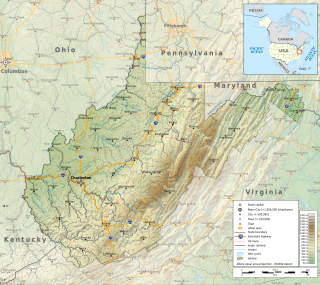
The Environment of West Virginia encompasses terrain and ecosystems ranging from plateaus to mountains. Most of West Virginia lies within the Appalachian mixed mesophytic forests ecoregion, while the higher elevations along the eastern border and in the panhandle lie within the Appalachian-Blue Ridge forests.

<span class="mw-page-title-main">Geography of Indiana</span> Overview of the geography of Indiana

The geography of Indiana comprises the physical features of the land and relative location of U.S. State of Indiana. Indiana is in the north-central United States and borders on Lake Michigan. Surrounding states are Michigan to the north and northeast, Illinois to the west, Kentucky to the south, and Ohio to the east. The entire southern boundary is the Ohio River.

<span class="mw-page-title-main">Geography of Nevada</span>

The landlocked U.S. state of Nevada has a varied geography and is almost entirely within the Basin and Range Province and is broken up by many north–south mountain ranges. Most of these ranges have endorheic valleys between them.

<span class="mw-page-title-main">Geography of Idaho</span> Overview of the Geograpny of Idaho

The U.S. state of Idaho borders six other U.S. states and one Canadian province. The states of Washington and Oregon are to the west, Nevada and Utah are to the south, and Montana and Wyoming are to the east. Idaho also shares a short border with the Canadian province of British Columbia to the north.

<span class="mw-page-title-main">Geography of Washington (state)</span> Overview of the Geography of Washington

Washington is the northwesternmost state of the contiguous United States. It borders Idaho to the east, bounded mostly by the meridian running north from the confluence of the Snake River and Clearwater River, except for the southernmost section where the border follows the Snake River. Oregon is to the south, with the Columbia River forming the western part and the 46th parallel forming the eastern part of the Oregon–Washington border. During Washington's partition from Oregon, the original plan for the border followed the Columbia River east until the confluence with the Snake, and then would have followed the Snake River east; this was changed to keep Walla Walla's fertile farmland in Washington.

<span class="mw-page-title-main">Lake Superior National Estuarine Research Reserve</span> Research reserve

The Lake Superior National Estuarine Research Reserve includes land and water areas along the St. Louis River and Lake Superior in Douglas County, in the northwest corner of Wisconsin, United States. It is one of 29 National Estuarine Research Reserves. The Reserve is operated as a program of the Natural Resources Institute of the University of Wisconsin-Madison Division of Extension. It has an area of 16,697 acres (6,757 ha), and was designated in 2010.

<span class="mw-page-title-main">Climate of Door County, Wisconsin</span>

The climate of Door County, Wisconsin is tempered by Green Bay and Lake Michigan. There are fewer extremely cold days and fewer hot days than in areas of Wisconsin directly to the west. Lake waters delay the coming of spring as well as extend mild temperatures in the fall. Annual precipitation is slightly lower than elsewhere in northern Wisconsin. The county features a humid continental climate with warm summers and cold snowy winters.

References

  1. "FAQ". Michigan Inland Lakes Partnership. Retrieved 2020-03-05.
  2. "Land and Water Area of States, 2000".
  3. "Michigan Dept. of Natural Resources".
  4. "Lighthouse Facts | US Lighthouse Society". uslhs.org. Archived from the original on 2023-08-18. Retrieved 2020-03-05.
  5. "Michigan Tourism Facts". Michigan Economic Development Corporation. Archived from the original on October 15, 2016. Retrieved July 25, 2016.
  6. "Thunderstorm Hazards". Archived from the original on October 15, 2006. Retrieved October 25, 2006. srh.noaa.gov. Last accessed November 1, 2006.
  7. "NOWData – NOAA Online Weather Data/". National Oceanic and Atmospheric Administration. Retrieved May 4, 2021.
  8. "Summary of Monthly Normals 1991–2020". National Oceanic and Atmospheric Administration. Archived from the original on May 4, 2021. Retrieved May 4, 2021.
  9. "Detroit/Metropolitan ARPT MI Climate Normals 1961–1990". National Oceanic and Atmospheric Administration. Retrieved July 18, 2020.
  10. "Historical UV Index Data - Detroit, MI". UV Index Today. Retrieved April 21, 2023.
  11. "Threadex". Archived from the original on March 5, 2020. Retrieved September 19, 2016.
  12. "NowData – NOAA Online Weather Data". National Oceanic and Atmospheric Administration. Archived from the original on May 8, 2021. Retrieved May 8, 2021.
  13. "Station: Grand Rapids, MI". National Oceanic and Atmospheric Administration. Archived from the original on May 8, 2021. Retrieved May 8, 2021.
  14. "WMO Climate Normals for Grand Rapids/Kent Co. Int'l Ar., MI 1961–1990". National Oceanic and Atmospheric Administration. Archived from the original on September 17, 2023. Retrieved March 10, 2014.
  15. "NowData – NOAA Online Weather Data". National Oceanic and Atmospheric Administration. Retrieved May 6, 2021.
  16. "Station: Lansing Capital City AP, MI". National Oceanic and Atmospheric Administration. Archived from the original on May 6, 2021. Retrieved May 6, 2021.
  17. "WMO Climate Normals for LANSING/CAPITAL CITY AP, MI 1961–1990". National Oceanic and Atmospheric Administration. Archived from the original on 2024-01-08. Retrieved March 30, 2014.
  18. "NOWData: NOAA Online Weather Data". National Oceanic and Atmospheric Administration. Retrieved May 5, 2021. Scroll down and select 'Marquette, MI', not 'Marquette Area'.
  19. "Summary of Monthly Normals 1991–2020". National Oceanic and Atmospheric Administration. Archived from the original on May 6, 2021. Retrieved May 6, 2021.
  20. "Marquette/FAA ARPT MI Climate Normals 1961–1990". National Oceanic and Atmospheric Administration. Archived from the original on 2023-09-15. Retrieved March 17, 2017.
  21. "NOWData – NOAA Online Weather Data". National Oceanic and Atmospheric Administration. Retrieved May 6, 2021.
  22. "Summary of Monthly Normals 1991–2020". National Oceanic and Atmospheric Administration. Archived from the original on May 6, 2021. Retrieved May 6, 2021.
  23. "Sault STE. MARIE, MI Climate Normals 1961–1990". National Oceanic and Atmospheric Administration. Retrieved September 4, 2020.