Saginaw County, Michigan

Last updated

Saginaw County
County of Saginaw
Saginaw County Governmental Center.JPG
Saginaw County Governmental Center in Saginaw
Flag of Saginaw County, Michigan.svg
Seal of Saginaw County, Michigan.png
Map of Michigan highlighting Saginaw County.svg
Location within the U.S. state of Michigan
Michigan in United States.svg
Michigan's location within the U.S.
Coordinates: 43°20′N84°03′W / 43.33°N 84.05°W / 43.33; -84.05
CountryFlag of the United States.svg United States
StateFlag of Michigan.svg  Michigan
FoundedFebruary 9, 1835 [1] [2]
Seat Saginaw
Largest citySaginaw
Area
  Total816 sq mi (2,110 km2)
  Land800 sq mi (2,000 km2)
  Water16 sq mi (40 km2)  1.9%
Population
 (2020)
  Total190,124
  Density250/sq mi (100/km2)
Time zone UTC−5 (Eastern)
  Summer (DST) UTC−4 (EDT)
Congressional district 8th
Website www.saginawcounty.com

Saginaw County, officially the County of Saginaw, is a county located in the U.S. state of Michigan. As of the 2020 Census, the population was 190,124. [3] The county seat is Saginaw. [1] [4] The county was created by September 10, 1822, and was fully organized on February 9, 1835. [1] The etymology of the county's name is uncertain. It may be derived from Sace-nong or Sak-e-nong (English: Sauk land), as the Sauk (French: Sac) tribe is believed by some to have once lived there. A more likely possibility is that it comes from Ojibwe words meaning "place of the outlet" –sag (English: an opening) and ong (English: place of). [5] See List of Michigan county name etymologies.

Contents

Saginaw County comprises the Saginaw, MI Metropolitan Statistical Area and is included in the Saginaw-Midland-Bay City Combined Statistical Area, the 5th largest metropolitan area in Michigan.

Etymology

The name Saginaw is widely believed to mean "where the Sauk were" in Ojibwe, from Sace-nong or Sak-e-nong (Sauk Town), due to the belief that the Sauk once lived there. But it is more likely that the name means "place of the outlet", from the Ojibwe sag (opening) and ong (place of). [6] [7]

When Natives told Samuel de Champlain that the Sauk nation was on the western shore of Lake Michigan, Champlain mistakenly placed them on the western shore of Lake Huron. This mistake was copied on subsequent maps, and future references identified this as the place of the Sauks. Champlain himself never visited what is now Michigan. [8]

History

The area was inhabited from about 1000 B.C. to 1000 A.D. by the Native American Hopewell culture, followed by the Anishnabeg. Some historians believe that the Sauk at one time lived in the area and were driven out by Ojibwe (Chippewa), before the area was first visited by Europeans.

The Saginaw region includes an extensive network of many rivers and streams which converge into the Saginaw River and provided a means for easy travel for the Native American population among numerous settlements and hunting areas, as well as access to Lake Huron. Saginaw was also a frequent meeting location for councils of the Ojibwe, Pottawatomi, and Ottawa—the Three Fires of the Anishnabeg. [9]

What is today Saginaw County was inhabited by the Ojibwe at the time of the arrival of Euro-Americans. The Ojibwe were still the dominant force in the area in the 1820s, and in 1827 they were attacked by a two groups of Winnebago people coming from Wisconsin. The Ojibwe prevailed in this fight with the aid of local Euro-American settlers. [10]

In 1853 the Ojibwe and Ottawa both established large hunting camps along the Saginaw River, although Euro-American settlers were beginning to establish saw mills and farms in the area by that point. [11]

Geography

According to the U.S. Census Bureau, the county has a total area of 816 square miles (2,110 km2), of which 800 square miles (2,100 km2) is land and 16 square miles (41 km2) (1.9%) is water. [12] It is part of the Flint/Tri-Cities region of Mid-Michigan. The median elevation in Saginaw County, Michigan is 620 feet (190 m) above sea level. [13]

Primary rivers

Wildlife refuge

Adjacent counties

Demographics

Historical population
CensusPop.Note
1840 892
1850 2,609192.5%
1860 12,693386.5%
1870 39,097208.0%
1880 59,09551.1%
1890 82,27339.2%
1900 81,222−1.3%
1910 89,2909.9%
1920 100,28612.3%
1930 120,71720.4%
1940 130,4688.1%
1950 153,51517.7%
1960 190,75224.3%
1970 219,74315.2%
1980 228,0593.8%
1990 211,946−7.1%
2000 210,039−0.9%
2010 200,169−4.7%
2020 190,124−5.0%
2023 (est.)187,782 [14] −1.2%
U.S. Decennial Census [15]
1790–1960 [16] 1900–1990 [17]
1990–2000 [18] 2010–2019 [3]

The 2010 United States Census [19] indicates Saginaw County had a 2010 population of 200,169. This is a decrease of -9,870 people from the 2000 United States Census. Overall, the county had a -4.7% growth rate during this ten-year period. In 2010 there were 79,011 households and 52,287 families in the county. The population density was 250.2 per square mile (96.6 per square kilometer). There were 86,844 housing units at an average density of 108.5 per square mile (41.9 per square kilometer). The racial and ethnic makeup of the county was 70.5% White, 18.6% Black or African American, 0.3% Native American, 1.0% Asian, 7.8% Hispanic or Latino, 0.1% from other races, and 1.6% from two or more races.

There were 79,011 households, out of which 30.5% had children under the age of 18 living with them, 45.4% were husband and wife families, 16.0% had a female householder with no husband present, 33.8% were non-families, and 28.2% were made up of individuals. The average household size was 2.44 and the average family size was 2.99.

In the county, 23.4% of the population was under the age of 18, 10.6% from 18 to 24, 22.9% from 25 to 44, 27.8% from 45 to 64, and 15.3% was 65 years of age or older. The median age was 40 years. For every 100 females there were 93.6 males. For every 100 females age 18 and over, there were 90.4 males.

The 2010 American Community Survey 1-year estimate [19] indicates the median income for a household in the county was $41,938 and the median income for a family was $52,243. Males had a median income of $27,691 versus $16,488 for females. The per capita income for the county was $21,025. About 12.4% of families and 16.9% of the population were below the poverty line, including 24.1% of those under the age 18 and 10.1% of those age 65 or over.

Religion

The Roman Catholic Diocese of Saginaw is the controlling regional body for the Catholic Church. [20]

Government and politics

The county government operates the jail, maintains rural roads, operates the major local courts, keeps files of deeds and mortgages, maintains vital records, administers public health regulations, and participates with the state in the provision of welfare and other social services. The county board of commissioners controls the budget but has only limited authority to make laws or ordinances. In Michigan, most local government functions — police and fire, building and zoning, tax assessment, street maintenance, etc. — are the responsibility of individual cities and townships.

From 1988 to 2012, Saginaw County was a consistently Democratic county at the Presidential level. However, in recent elections it has become increasingly competitive, with Donald Trump narrowly winning the county in 2016 by slightly over 1,000 votes while narrowly losing it in 2020 by about 300 votes. Since 1992, the county has voted for the statewide winner in every election, and is thus considered a bellwether politically.

United States presidential election results for Saginaw County, Michigan [21] [22]
Year Republican Democratic Third party
No.%No.%No.%
2020 50,78549.08%51,08849.37%1,6101.56%
2016 45,46947.97%44,39646.84%4,9155.19%
2012 42,72043.46%54,38155.33%1,1911.21%
2008 42,22540.49%60,27657.80%1,7821.71%
2004 47,16545.86%54,88753.37%8000.78%
2000 41,15243.89%50,82554.21%1,7791.90%
1996 31,57735.97%47,57954.19%8,6389.84%
1992 32,10333.13%43,81945.22%20,98321.65%
1988 42,40147.88%45,61651.51%5490.62%
1984 51,49556.95%38,42042.49%5010.55%
1980 45,23348.22%41,65044.40%6,9167.37%
1976 46,76555.63%36,28043.15%1,0261.22%
1972 47,92061.03%29,42437.47%1,1771.50%
1968 38,07049.17%32,26641.67%7,0879.15%
1964 28,14638.25%45,30961.58%1270.17%
1960 41,35155.68%32,71544.05%2060.28%
1956 43,47062.67%25,68137.03%2100.30%
1952 38,60464.23%20,98334.91%5130.85%
1948 22,92356.28%16,99541.72%8152.00%
1944 27,28956.38%20,38342.11%7301.51%
1940 27,04254.35%22,49045.20%2210.44%
1936 15,52737.50%22,59254.56%3,2917.95%
1932 17,79442.97%22,64354.67%9772.36%
1928 22,46765.61%11,55533.75%2200.64%
1924 23,61867.99%6,20617.87%4,91414.15%
1920 20,42568.24%8,49428.38%1,0133.38%
1916 9,54451.70%8,43445.69%4832.62%
1912 5,03227.94%5,84532.46%7,13039.60%
1908 9,44754.41%7,01940.42%8985.17%
1904 10,14660.66%5,33031.86%1,2517.48%
1900 8,41350.17%7,61045.38%7464.45%
1896 8,36147.92%8,79250.39%2941.69%
1892 6,73744.37%7,60150.07%8445.56%
1888 6,72341.95%8,92355.68%3792.37%
1884 5,93944.68%7,04753.02%3052.29%
1880 5,20746.78%5,30447.65%6215.58%

Elected officials

All countywide officers are elected for four-year terms. The next scheduled election for these offices is November 2024.

(information as of April 2021)

Parks and Recreation Commission

Saginaw County Parks and Recreation Commission is a county-wide government organization founded by William H. Haithco Sr. in 1969. Haithco then served as chairman from 1972 to 1999. [23] The organization operates six parks throughout the county - Imerman Memorial Park, Veterans Memorial Park, Ringwood Forest, Price Nature Center, William H. Haithco Recreation Area, and The Saginaw Valley Rail Trail. These parks comprise over 550 acres, including 18 miles of hiking trails, two boat launches, four fishing access sites, a swimming beach, picnic shelters, and recreation programs. [24] [25]

Economy

The largest employers in Saginaw County are: [26]

#Employer# of employees
1 Nexteer Automotive 5200
2 Covenant HealthCare 4512
3 St. Mary's of Michigan 1800
4 Morley Companies 1750
5 Meijer 1425
6 Saginaw Valley State University 1071
7 Hemlock Semiconductor Corporation 1000
8 Frankenmuth Bavarian Inn 940
9 Aleda E. Lutz Veteran Affairs Medical Center904
10County of Saginaw676
11 Saginaw Public Schools 657
12 Fashion Square Mall 650
13 Saginaw Township Community Schools 621
14 Saginaw Intermediate School District 613
15 Frankenmuth Insurance 694

Transportation

Saginaw County was the destination of a Sauk footpath that became one of the first roads in what is now Michigan, the Saginaw Trail. The trail, first authorized in 1819, was completed to Saginaw in 1841. Since then, Saginaw's access to the outside world has expanded with the development of maritime, rail, air, and freeway links to the major cities of Michigan and neighboring states and nations.

Airports

Scheduled airline service is available from MBS International Airport [27] near Freeland, Michigan and Bishop International Airport in Flint, Michigan. [28] Harry Browne Airport [29] in Buena Vista Charter Township also serves the region.

Highways

Maritime

The Saginaw River is maintained by the Corps of Engineers, and from time to time, dredged to maintain a shipping channel down the river to Bay City, and from there, to the Great Lakes.

Education

Michigan Lutheran Seminary in Saginaw Michigan Lutheran Seminary front 1a.jpg
Michigan Lutheran Seminary in Saginaw

Primary and secondary education

Public schools

Most of Saginaw County is served by the Saginaw Intermediate School District (SISD), which coordinates the efforts of local boards of education, but has no operating authority over schools. Local school boards in Michigan retain great autonomy over day-to-day operations. A number of charter schools also operate in the county.

School districts in the county (including any with any territory, no matter how slight, even if the schools and/or administration are in other counties) include: [31]

Former school districts include: [32]

Higher education

Notable natives

Historical markers

There are twenty eight recognized historical markers in the county: [34] They are:

Communities

U.S. Census data map showing local municipal boundaries within Saginaw County. Shaded areas represent incorporated cities. Saginaw County, MI census map.png
U.S. Census data map showing local municipal boundaries within Saginaw County. Shaded areas represent incorporated cities.

Cities

Villages

Charter townships

Civil townships

Census-designated places

Other unincorporated communities

See also

Related Research Articles

<span class="mw-page-title-main">Tuscola County, Michigan</span> County in Michigan, United States

Tuscola County is a county in the Thumb region of the U.S. state of Michigan. As of the 2020 census, the population was 53,323. The county seat is Caro. The county was created by Michigan Law on April 1, 1840, from land in Sanilac County and attached to Saginaw County for administrative purposes. The Michigan Legislature passed an act on March 2, 1850, that empowered the county residents to organize governmental functions.

<span class="mw-page-title-main">Shiawassee County, Michigan</span> County in Michigan, United States

Shiawassee County is a county located in the U.S. state of Michigan. As of the 2020 United States Census, the population was 68,094. The county seat is Corunna, and the largest city in the county is Owosso. In 2010, the center of population of Michigan was located in Shiawassee County, in Bennington Township.

<span class="mw-page-title-main">Genesee County, Michigan</span> County in Michigan, United States

Genesee County is a county in the U.S. state of Michigan. As of the 2020 Census, the population was 406,211, making it the fifth-most populous county in Michigan. The county seat and population center is Flint. Genesee County consists of 33 cities, townships, and villages. It is considered to be a part of the greater Mid Michigan area.

<span class="mw-page-title-main">Frankenlust Township, Michigan</span> Civil township in Michigan, United States

Frankenlust Township is a civil township of Bay County in the U.S. state of Michigan. The 2020 Census placed the population at 3,672. This is a 3.1% increase from the 3,562 recorded at the 2010 Census, the second largest increase in Bay County during that time period. The 2000 Census recorded 2,530. It is included in the Bay City Metropolitan Statistical Area. It is home to Delta College.

<span class="mw-page-title-main">Springfield Township, Oakland County, Michigan</span> Charter township in Michigan, United States

Springfield Charter Township is a charter township of Oakland County in the U.S. state of Michigan. As of the 2020 census, the township population was 14,703. The township was named for the numerous springs in the area.

<span class="mw-page-title-main">Buena Vista Charter Township, Michigan</span> Charter township in Michigan, United States

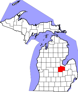
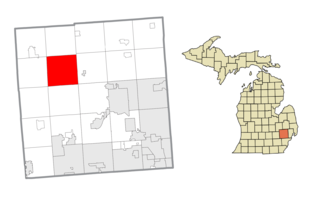
Buena Vista Charter Township is a charter township of Saginaw County in the U.S. state of Michigan. Per the 2020 census, the population was 7,664.

<span class="mw-page-title-main">Chesaning, Michigan</span> Village in Michigan, United States

Chesaning is a village in Saginaw County in the U.S. state of Michigan. The population was 2,394 at the 2010 census. The village is located within Chesaning Township.

<span class="mw-page-title-main">Chesaning Township, Michigan</span> Civil township in Michigan, United States

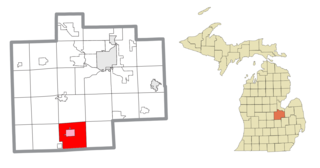
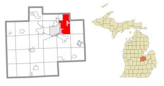
Chesaning Township is a civil township of Saginaw County in the U.S. state of Michigan. The population was 4,748 at the 2020 Census. The township was organized in 1847.

<span class="mw-page-title-main">Frankenmuth, Michigan</span> City in Michigan, United States

Frankenmuth is a city in Saginaw County in the U.S. state of Michigan. The population was 4,987 at the 2020 census. The city is surrounded by Frankenmuth Township.

<span class="mw-page-title-main">Freeland, Michigan</span> Census-designated place & unincorporated community in Michigan, United States

Freeland is a census-designated place in Tittabawassee Township, Saginaw County in the U.S. state of Michigan. It is part of the Saginaw-Midland-Bay Metropolitan Area. As of the 2000 census, the CDP population was 5,147. The CDP covers an area in the central portion of Tittabawassee Township. The Freeland post office, ZIP code 48623, serves nearly the entire township, as well as portions of Midland and Williams townships to the north, Frankenlust and Kochville townships to the east, Thomas and Richland townships to the south, and Ingersoll Township to the west.

<span class="mw-page-title-main">Saginaw, Michigan</span> City in Michigan, United States

Saginaw is a city in and the seat of Saginaw County, Michigan, United States. The city proper had a population of 44,202 at the 2020 census. Located along the Saginaw River, Saginaw is adjacent to Saginaw Charter Township and considered part of Greater Tri-Cities region of Central Michigan. The Saginaw metropolitan area had a population of 190,124 in 2020. The city is also the largest municipality in the Greater Tri-Cities, with a combined population of 377,474 in the combined statistical area in 2020.

The Thumb is a region and a peninsula of the U.S. state of Michigan, so named because the Lower Peninsula is shaped like a mitten. The Thumb area is generally considered to be in the Central Michigan region, east of the Tri-Cities and north of Metro Detroit. The region is also branded as the Blue Water Area.

<span class="mw-page-title-main">Shiawassee River</span> River in Michigan, United States

The Shiawassee River in the U.S. state of Michigan drains an area of 1,201 square miles (3,110 km2) within Oakland, Genesee, Livingston, Shiawassee, Midland and Saginaw counties. It flows in a generally northerly direction for approximately 110 miles (180 km) from its source to its confluence with the Tittabawassee River creating the Saginaw River, which drains into Saginaw Bay of Lake Huron.

<span class="mw-page-title-main">Central Michigan</span> Lower Peninsula of Michigan in the United States

Central Michigan, also called Mid Michigan, is a region in the Lower Peninsula of the U.S. state of Michigan. As its name implies, it is the middle area of the Lower Peninsula. Lower Michigan is said to resemble a mitten, and Mid Michigan corresponds roughly to the thumb and palm, stretching from Michigan's eastern shoreline along Lake Huron into the fertile rolling plains of the Michigan Basin. The region contains cities of moderate size, including Flint, Saginaw, and the state capital of Lansing. Generally Central, or "Mid", Michigan is defined by governmental organizations as an area North of Jackson, and South of Clare.

<span class="mw-page-title-main">Saginaw Public School District</span> School district in Michigan

The School District of the City of Saginaw, known also as the Saginaw Public School District (SPSD) or Saginaw Public Schools, is a school district in Saginaw, Michigan. The district is a part of the Saginaw Intermediate School District, and serves the cities of Saginaw and Zilwaukee, the eastern part of Kochville Township, and portions of Buena Vista Township north of Hess Avenue.

Buena Vista School District was a school district headquartered in Buena Vista Charter Township, Michigan, and part of the Saginaw Intermediate School District. As of July 2013, the school district closed and became a tax-collecting district of the Saginaw ISD to pay the district's outstanding debts.

Frankenmuth School District is a school district headquartered in Frankenmuth, Michigan. It is a part of the Saginaw Intermediate School District and serves the Frankenmuth area. Its schools include the Preschool, List Elementary School, E.F. Rittmueller Middle School, and Frankenmuth High School.

The Saginaw Intermediate School District (SISD) is an intermediate school district in Michigan, headquartered in Saginaw.

<span class="mw-page-title-main">Saginaw, Midland, and Bay City metropolitan area</span> CSA in Michigan, United States

The Saginaw-Midland-Bay City Combined Statistical Area is a United States metropolitan area defined by the federal Office of Management and Budget (OMB) surrounding the Saginaw Bay and Saginaw River. The region is a part of the larger area known as Mid/Central Michigan. It includes the smaller statistical areas of Saginaw, Midland, and Bay City.

References

  1. 1 2 3 "Bibliography on Saginaw County". Clarke Historical Library, Central Michigan University . Retrieved January 29, 2013.
  2. Saginaw County
  3. 1 2 "State & County QuickFacts". United States Census Bureau. Retrieved September 15, 2021.
  4. "Find a County". National Association of Counties. Retrieved June 7, 2011.
  5. Michigan County names per the Michigan government.
  6. "Clarke Home—entral Michigan University". cmich.edu.
  7. Michigan Counties. DNR. Retrieved November 5, 2012.
  8. Saginaw's Changeable Past, by Jeremy W. Kilar, G. Bradley, St. Louis, MO, 1994, p. 15
  9. Saginaw' Changeable Past, Jeremy W. Kilar, G. Bradley, St.Louis, MO, 1994, p15
  10. History of Sagimaw County, Michigan (Chicago: Charles C. Chapman & Co, 1881) p. 120
  11. History of Saginaw County, p. 123-124
  12. "2010 Census Gazetteer Files". United States Census Bureau. August 22, 2012. Archived from the original on November 13, 2013. Retrieved September 28, 2014.
  13. "Saginaw County, Michigan Geography Analysis" . Retrieved December 12, 2014.
  14. "Annual Estimates of the Resident Population for Counties: April 1, 2020 to July 1, 2023". United States Census Bureau. Retrieved April 4, 2024.
  15. "U.S. Decennial Census". United States Census Bureau. Retrieved September 28, 2014.
  16. "Historical Census Browser". University of Virginia Library. Retrieved September 28, 2014.
  17. "Population of Counties by Decennial Census: 1900 to 1990". United States Census Bureau. Retrieved September 28, 2014.
  18. "Census 2000 PHC-T-4. Ranking Tables for Counties: 1990 and 2000" (PDF). United States Census Bureau. Archived (PDF) from the original on March 27, 2010. Retrieved September 28, 2014.
  19. 1 2 "U.S. Census website". United States Census Bureau . Retrieved March 11, 2012.
  20. "Diocese of Saginaw". saginaw.org.
  21. "Dave Leip's Atlas of U.S. Presidential Elections".
  22. The leading "other" candidate, Progressive Theodore Roosevelt, received 5,664 votes, while Socialist candidate Eugene Debs received 1,291 votes, and Prohibition candidate Eugene Chafin received 175 votes.
  23. Johnson, Bob (March 20, 2011). "A life remembered: William H. Haithco Sr., father of parks and recreation in Saginaw County". MLive. Retrieved July 10, 2014.
  24. "Parks and Recreation Commission - About Us". County of Saginaw, Michigan. Retrieved July 10, 2014.
  25. "Children's Fun Day is Tuesday at Haithco Park in Saginaw Twp". WEYI. July 16, 2010. Retrieved July 10, 2014.
  26. Saginaw County Primary Employers.
  27. "MBS International Airport". mbsairport.org.
  28. "Bishop International Airport: Flint, Michigan: Flights & Airport Travel". bishopairport.org.
  29. Jeff Turner. "Saginaw Browne Airport Aircraft Services". khyx.org.
  30. "M-46 Endpoint Photos". state-ends.com. Archived from the original on April 14, 2005.
  31. "2020 CENSUS - SCHOOL DISTRICT REFERENCE MAP: Saginaw County, MI" (PDF). U.S. Census Bureau. Archived (PDF) from the original on July 22, 2022. Retrieved July 22, 2022. - Text list
  32. "SCHOOL DISTRICT REFERENCE MAP (2010 CENSUS): Saginaw County, MI" (PDF). U.S. Census Bureau. Archived (PDF) from the original on August 24, 2017. Retrieved July 22, 2022. - Text list
  33. 'Wisconsin Blue Book 1926,' Biographical sketch of George C. Hinkley, pg. 714
  34. "Michigan Historical Markers". michmarkers.com. Archived from the original on March 15, 2010.

Further reading

43°20′N84°03′W / 43.33°N 84.05°W / 43.33; -84.05