Outline of Michigan

Last updated

The location of the state of Michigan in the United States of America Map of USA MI.svg
The location of the state of Michigan in the United States of America

The following outline provides an overview of and topical guide to the U.S. state of Michigan:

Contents

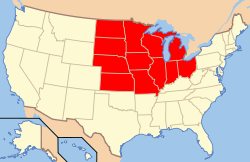
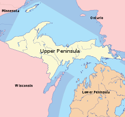
Michigan is located in the Great Lakes Region of the United States of America, comprising two peninsulas.

General reference

An enlargeable map of the state of Michigan Map of Michigan NA.png
An enlargeable map of the state of Michigan

Geography of Michigan

Geography of Michigan

Location of Michigan

Location: 41° 41' N to 48° 18' N latitude, 82° 7' W to 90° 25' W longitude

Demography of Michigan

Environment of Michigan

Natural geographic features of Michigan

Places in Michigan

Regions of Michigan

Great Lakes Region.png
Great Lakes region
Map of USA Midwest.svg
Midwest region
MichiganUpperPeninsula.svg
Upper Peninsula
Michigan Lower Peninsula Regions.png
Lower Peninsula Regions

Government and politics of Michigan

Government of Michigan

Branches of the government of Michigan

Government of Michigan

Military in Michigan

Local government in Michigan

Administrative Divisions of Michigan

An enlargeable map of the 83 counties of the State of Michigan MichiganCounties.svg
An enlargeable map of the 83 counties of the State of Michigan

Laws in Michigan

Law enforcement in Michigan

History of Michigan

Historic locations in Michigan

Historical libraries, societies and museums in Michigan

History of Michigan, by period

History of Michigan, by region

History of Michigan, by subject

History of Michigan, lists of people

History of Michigan, people

History publications about Michigan

Culture of Michigan

The Flag of the State of Michigan Flag of Michigan.svg
The Flag of the State of Michigan
The Great Seal of the State of Michigan Seal of Michigan.svg
The Great Seal of the State of Michigan

The Arts in Michigan

Culture by region

Sports in Michigan

Sports in Michigan

Economy and infrastructure of Michigan

Education in Michigan

Education in Michigan

See also

Related Research Articles

<span class="mw-page-title-main">Lower Peninsula of Michigan</span> Michigan in the United States

The Lower Peninsula of Michigan – also known as Lower Michigan – is the larger, southern and less elevated of the two major landmasses that make up the U.S. state of Michigan; the other being the Upper Peninsula, which is separated by the Straits of Mackinac. It is surrounded by water on all sides except its southern border, which it shares with Indiana and Ohio. Although the Upper Peninsula is commonly referred to as "the U.P.", it is uncommon for the Lower Peninsula to be called "the L.P."

<span class="mw-page-title-main">Michigan</span> U.S. state

Michigan is a state in the Great Lakes region of the Upper Midwestern United States. It borders Wisconsin to the northwest in the Upper Peninsula, and Indiana and Ohio to the south in the Lower Peninsula; it is also connected by Lakes Superior, Michigan, Huron, and Erie to Minnesota and Illinois, and the Canadian province of Ontario. With a population of nearly 10.12 million and an area of 96,716 sq mi (250,490 km2), Michigan is the 10th-largest state by population, the 11th-largest by area, and the largest by area east of the Mississippi River. Its capital is Lansing, and its largest city is Detroit. Metro Detroit is among the nation's most populous and largest metropolitan economies. The name derives from a gallicized variant of the original Ojibwe word ᒥᓯᑲᒥ, meaning "large water" or "large lake".

<span class="mw-page-title-main">Upper Peninsula of Michigan</span> Northern major peninsula of the U.S. state of Michigan

The Upper Peninsulaof Michigan—also known as Upper Michigan or colloquially the U.P.—is the northern and more elevated of the two major landmasses that make up the U.S. state of Michigan; it is separated from the Lower Peninsula by the Straits of Mackinac. It is bounded primarily by Lake Superior to the north, separated from the Canadian province of Ontario at the east end by the St. Marys River, and flanked by Lake Huron and Lake Michigan along much of its south. Although the peninsula extends as a geographic feature into the state of Wisconsin, the state boundary follows the Montreal and Menominee rivers and a line connecting them.

<span class="mw-page-title-main">Wayne County, Michigan</span> County in Michigan, United States

Wayne County is the most populous county in the U.S. state of Michigan. As of 2020, the United States Census placed its population at 1,793,561, making it the 19th-most populous county in the United States. The county seat is Detroit. The county was founded in 1796 and organized in 1815. Wayne County is included in the Detroit-Warren-Dearborn, MI Metropolitan Statistical Area. It is one of several U.S. counties named after Revolutionary War-era general Anthony Wayne.

<span class="mw-page-title-main">Keweenaw County, Michigan</span> County in Michigan, United States

Keweenaw County is a county in the western Upper Peninsula of the U.S. state of Michigan. As of the 2020 census, the county's population was 2,046, making it Michigan's least populous county. It is also the state's largest county by total area, including the waters of Lake Superior, as well as the state's northernmost county. The county seat is Eagle River.

<span class="mw-page-title-main">Houghton County, Michigan</span> County in Michigan, United States

Houghton County is a county in the Upper Peninsula in the U.S. state of Michigan. As of the 2020 census, the population was 37,361. The county seat and largest city is Houghton. Both the county and the city were named for Michigan State geologist and Detroit Mayor Douglass Houghton.

<span class="mw-page-title-main">L'Anse Township, Michigan</span> Civil township in Michigan, United States

L'Anse Township is a civil township of Baraga County in the U.S. state of Michigan. As of the 2020 census, the township population was 3,551. The township contains Mount Arvon and Mount Curwood, Michigans highest and second-highest points, as well as the village of L'Anse.

<span class="mw-page-title-main">Mackinaw City, Michigan</span> Village in Michigan, United States

Mackinaw City is a village at the northernmost point of the Lower Peninsula of Michigan, United States. Divided between Cheboygan and Emmet counties, Mackinaw City is the located at the southern end of the Mackinac Bridge, which carries Interstate 75 over the Straits of Mackinac to the Upper Peninsula. Mackinaw City, along with St. Ignace, serves as an access point to Mackinac Island. For these reasons, Mackinaw City is considered one of Michigan's most popular tourist attractions.

<span class="mw-page-title-main">Index of Michigan-related articles</span>

The following is an alphabetical list of articles related to the U.S. state of Michigan.

<span class="mw-page-title-main">Fort Michilimackinac</span> Archaeological site in Michigan, United States

Fort Michilimackinac was an 18th-century French, and later British, fort and trading post at the Straits of Mackinac; it was built on the northern tip of the lower peninsula of the present-day state of Michigan in the United States. Built around 1715, and abandoned in 1783, it was located along the Straits, which connect Lake Huron and Lake Michigan of the Great Lakes of North America.

<span class="mw-page-title-main">Copper Harbor, Michigan</span> Census-designated place & unincorporated community in Michigan, United States

Copper Harbor is an unincorporated community and census-designated place (CDP) located in Keweenaw County in the U.S. state of Michigan. It is located within Grant Township. The population of the CDP was 136 as of the 2020 census.

<span class="mw-page-title-main">Keweenaw National Historical Park</span> U.S. national historical park in Michigan

Keweenaw National Historical Park is a unit of the U.S. National Park Service. Established in 1992, the park celebrates the life and history of the Keweenaw Peninsula in the Upper Peninsula of the U.S. state of Michigan. It is a federal-local cooperative park made up of two primary units, the Calumet Unit and the Quincy Unit, and almost two dozen cooperating "Heritage Sites" located on federal, state, and privately owned land in and around the Keweenaw Peninsula. The National Park Service owns approximately 1,700 acres (690 ha) in the Calumet and Quincy Units. Units are located in Baraga, Houghton, Keweenaw, and Ontonagon counties.

<span class="mw-page-title-main">History of Michigan</span> History of the US state of Michigan

The history of human activity in Michigan, a U.S. state in the Great Lakes, began with settlement of the western Great Lakes region by Paleo-Indians perhaps as early as 11,000 B.C.E. One early technology they developed was the use of native copper, which they would fashion into tools and other implements with "hammer stones". The first Europeans to arrive in Michigan were the French. Explorer Étienne Brûlé traveled through Michigan in 1618 searching for a route to China. Soon the French laid claim to the land and began to trade with the local natives for furs. Men called "voyageurs" would travel the rivers by canoe trading various goods for furs that would bring a high price back in Europe.

<span class="mw-page-title-main">National Register of Historic Places listings in Keweenaw County, Michigan</span>

The following is a list of Registered Historic Places in Keweenaw County, Michigan.
     This National Park Service list is complete through NPS recent listings posted February 9, 2024.

<span class="mw-page-title-main">Eagle Harbor Light</span> Lighthouse in Michigan, United States

Eagle Harbor Light is an operational lighthouse at Eagle Harbor, in Keweenaw County in the state of Michigan. It sits on the rocky entrance to Eagle Harbor and is one of several light stations that guide mariners on Lake Superior across the northern edge of the Keweenaw Peninsula. The original lighthouse, built in 1851, was replaced in 1871 by the present red brick structure, which is a Michigan State Historic Site and listed on the National Register of Historic Places.

Manitou Island is a small island in Lake Superior, off the northeastern tip of the Keweenaw Peninsula in the U.S. state of Michigan. It is part of Grant Township, in Keweenaw County. Located approximately three miles from the mainland, it encompasses around 1,000 acres (4.0 km2). Manitou has seen limited impact from human activity because of its remote location and the often-treacherous waters caused by a strong current at the peninsula's tip. It is mostly forested, with scattered bogs and an inland lake known as "Perch Lake". Dense underbrush can make travel around the island rather difficult, though a few unimproved trails do exist. The Keweenaw Land Trust protects 93 acres (0.38 km2) of the island as the Manitou Island Light Station Preserve.

<span class="mw-page-title-main">U.S. Route 41 in Michigan</span> U.S. Highway in Michigan

US Highway 41 (US 41) is a part of the United States Numbered Highway System that runs from Miami, Florida, to the Upper Peninsula of the US state of Michigan. In Michigan, it is a state trunkline highway that enters the state via the Interstate Bridge between Marinette, Wisconsin, and Menominee, Michigan. The 278.769 miles (448.635 km) of US 41 that lie within Michigan serve as a major conduit. Most of the highway is listed on the National Highway System. Various sections are rural two-lane highway, urbanized four-lane divided expressway and the Copper Country Trail National Scenic Byway. The northernmost community along the highway is Copper Harbor at the tip of the Keweenaw Peninsula. The trunkline ends at a cul-de-sac east of Fort Wilkins State Park after serving the Central Upper Peninsula and Copper Country regions of Michigan.

<span class="mw-page-title-main">Outline of Illinois</span> Overview of and topical guide to Illinois

The following outline is provided as an overview of and topical guide to the U.S. state of Illinois:

<span class="mw-page-title-main">Outline of Wisconsin</span> Overview of and topical guide to Wisconsin

The following outline is provided as an overview of, and a topical guide to, the U.S. state of Wisconsin:

References

  1. Barry Popik, Smoky City, barrypopik.com website, March 27, 2005
  2. "RESIDENT POPULATION OF THE 50 STATES, THE DISTRICT OF COLUMBIA, AND PUERTO RICO: 2010 CENSUS" (PDF). United States Census Bureau. Archived from the original (PDF) on January 24, 2011. Retrieved December 21, 2010.
  3. "Compilation of Databases on Michigan Lakes" (PDF). MichiganDNR.com. Retrieved April 18, 2009.
  4. "Zip Code Listings for Michigan", Mongabay web site