East North Central states

Last updated
East North Central
Chicago skyline from the North Avenue Beach Pier (cropped).jpg
Downtown Cincinnati viewed from Mt. Adams.jpg
Moon over Cleveland (33388400986).jpg
Detroit Skyline (123143197).jpeg
Top, left to right: Chicago, Cincinnati, Cleveland, and Detroit
US map-E North Central.PNG
Composition
Metropolitan areas
Area
  Total299,170 sq mi (774,800 km2)
Population
 (2020)
  Total47,368,533
  Density158/sq mi (61/km2)
Ethnic origins in East North Central Ethnic Origins in the East North Central United States.png
Ethnic origins in East North Central

The East North Central states is a region of the United States defined by the U.S. Census Bureau, containing five states: Illinois, Indiana, Michigan, Ohio and Wisconsin. [1] These states border the Great Lakes, West North Central, the Southeastern, and Northeastern states; the Eastern North Central states also share a land border with Canada through Michigan's Upper Peninsula, southeastern, and mid-Michigan regions. As one of two subregional divisions used to categorize the Midwest, East North Central closely matches the area of the Northwest Territory, excluding a portion of Minnesota.

Contents

The East North Central states also form a large part of the Great Lakes region, [2] although the latter also includes Minnesota, New York, Pennsylvania and the Canadian province of Ontario. It has a low rate of population growth and the estimated population as of 2019 was 46,902,431, [3] though the 2020 census numbered 47,368,533 residents. The Great Lakes bordering the area provide access to the Atlantic Ocean via the Great Lakes Waterway and St. Lawrence Seaway, or by the Erie Canal and the Hudson River, or via the Gulf of Mexico from the Mississippi River and the Illinois Waterway. Chicago and Detroit—two of East North Central's largest cities—are among the major ports of the United States.

Culturally, this region of the U.S. has been historically influenced by the British and French; Anglo-American culture permeated states covering the region following the expansion of the United States. Religiously, the East North Central states have been and remain predominantly affiliated with Christianity. Altogether, the five states are majority Catholic, non- and inter-denominational, Methodist, Lutheran, and Baptist. The largest non-Christian religion has been Islam. [4]

History

East North Central United States in 1908 from The Harmsworth atlas and Gazetter The Harmsworth atlas and Gazetter 1908 (135851561).jpg
East North Central United States in 1908 from The Harmsworth atlas and Gazetter

During European colonization of the Americas, the modern-day East North Central states was occupied by numerous American Indian tribes; with the introduction of European Americans into the region, it was divided between the British colonial empire in America and New France. The western portion of this region formed part of French Louisiana, [5] [6] and following U.S. independence, the eastern half was ceded to the United States from Great Britain. [7] Since American settlement, the modern-day East North Central states has remained the most populous division of the Midwest despite the overall region's low population growth rates.

Geography

Geographically located within the North, East North Central is considered part of the Midwest and Great Lakes regions, sharing maritime and land borders with Canada. [2] As half of the Midwest, the majority of it shares a humid continental climate, and many of its coastal settlements encounter lake effect snow during the winter.

States in the East North Central region
State2019 estimateLand area
Illinois 12,671,82157,915
Indiana 6,732,21936,418
Michigan 9,986,85796,716
Ohio 11,689,10044,825
Wisconsin 5,822,43465,497

Demographics

In 2010, the East North Central states had a population of 46,421,564; this grew to an estimated 46,902,431 by 2019. [8] By the 2020 United States census, the region's population increased to 47,368,533. Of its population, Illinois is the region's most populous with a 2020 population of 12,812,508. [9] Its least populous is Wisconsin, with 5,893,718 residents. [10] Chicago is the region's most populous city and largest metropolitan area. According to the 2010 American Community Survey, 49.1% of the residents were male and 50.9% were female. Approximately 24.0% of the population were under 18 years of age, and 13.4% were over 65 years of age, and the median age for the region was 39.2.

In terms of race and ethnicity as of 2012, White Americans made up 79.5% of the population, of which 75.7% were whites of non-Hispanic origin. Black Americans composed 12.1% of the region's population, of which 11.9% were blacks of non-Hispanic origin. American Indians and Alaskan Natives were 0.4% of the population and Asians were 2.7%. People who were of two or more races formed 2.1% of the population; and Hispanics and Latinos of any race made up 7.6%. [11]

Linguistically, English is, by far, the most common language spoken at home. Approximately 89.3% of all residents (38.3 million people) over the age of five spoke only English at home. Roughly 2,516,000 people (5.9% of the population) spoke Spanish at home and roughly 2,016,000 people (5.8% of the population) spoke another languages at home. Around 270,000 (0.6%) spoke German at home, although this figure ranges from 2% to 37% in Northeast Ohio, which is home to a large Amish community. [12] [13]

Largest cities by population
City2019 pop.
1 Chicago, Illinois2,693,976
2 Columbus, Ohio 898,553
3 Indianapolis, Indiana876,384
4 Detroit, Michigan670,031
5 Milwaukee, Wisconsin590,157
6 Cleveland, Ohio381,009
7 Cincinnati, Ohio303,940
8 Toledo, Ohio 272,779
9 Fort Wayne, Indiana 270,402
10 Madison, Wisconsin 259,680
Largest metropolitan areas by population
MSA2019 pop.
1 Chicago-Naperville-Elgin, IL-IN-WI MSA 9,458,539
2 Detroit-Warren-Dearborn, MI MSA 4,319,629
3 Cincinnati, OH-KY-IN MSA 2,221,208
4 Columbus, OH MSA 2,122,271
5 Indianapolis-Carmel-Anderson, IN MSA 2,074,537
6 Cleveland-Elyria, OH MSA 2,048,449
7 Milwaukee-Waukesha, WI MSA 1,575,179
8 Grand Rapids-Kentwood, MI MSA 1,077,370
9 Dayton-Kettering, OH MSA 807,611
10 Akron, OH MSA 703,479

Politics

Parties
Democratic-Republican Democratic Whig Republican Progressive
2020 United States Presidential Election Results in

East North Central

PartyTotal votersPercentage
Joe Biden (D)11,828,28849.8%
Donald Trump (R)11,591,49448.8%
Jo Jorgensen (L)291,8851.2%
Total23,711,667100%

There are also two deregistered parties that have active executive committees.

The Greens
Libertarian
Presidential electoral votes in the East North Central states since 1804
YearIllinoisIndianaMichiganOhioWisconsin
1804 No electionNo electionNo election Jefferson No election
1808 No electionNo electionNo election Madison No election
1812 No electionNo electionNo election Madison No election
1816 No election Monroe No election Monroe No election
1820 Monroe Monroe No election Monroe No election
1824 Jackson Jackson No election Clay No election
1828 Jackson Jackson No election Jackson No election
1832 Jackson Jackson No election Jackson No election
1836 Van Buren Harrison Van Buren Harrison No election
1840 Van Buren Harrison Harrison Harrison No election
1844 Polk Polk Polk Clay No election
1848 Cass Cass Cass Cass Cass
1852 Pierce Pierce Pierce Pierce Pierce
1856 Buchanan Buchanan Frémont Frémont Frémont
1860 Lincoln Lincoln Lincoln Lincoln Lincoln
1864 Lincoln Lincoln Lincoln Lincoln Lincoln
1868 Grant Grant Grant Grant Grant
1872 Grant Grant Grant Grant Grant
1876 Hayes Tilden Hayes Hayes Hayes
1880 Garfield Garfield Garfield Garfield Garfield
1884 Blaine Cleveland Blaine Blaine Blaine
1888 Harrison Harrison Harrison Harrison Harrison
1892 Cleveland Cleveland Harrison Harrison Cleveland
1896 McKinley McKinley McKinley McKinley McKinley
1900 McKinley McKinley McKinley McKinley McKinley
1904 Roosevelt Roosevelt Roosevelt Roosevelt Roosevelt
1908 Taft Taft Taft Taft Taft
1912 Wilson Wilson Roosevelt Wilson Wilson
1916 Hughes Hughes Hughes Wilson Hughes
1920 Harding Harding Harding Harding Harding
1924 Coolidge Coolidge Coolidge Coolidge La Follette
1928 Hoover Hoover Hoover Hoover Hoover
1932 Roosevelt Roosevelt Roosevelt Roosevelt Roosevelt
1936 Roosevelt Roosevelt Roosevelt Roosevelt Roosevelt
1940 Roosevelt Willkie Willkie Roosevelt Roosevelt
1944 Roosevelt Dewey Roosevelt Dewey Dewey
1948 Truman Dewey Dewey Truman Truman
1952 Eisenhower Eisenhower Eisenhower Eisenhower Eisenhower
1956 Eisenhower Eisenhower Eisenhower Eisenhower Eisenhower
1960 Kennedy Nixon Kennedy Nixon Nixon
1964 Johnson Johnson Johnson Johnson Johnson
1968 Nixon Nixon Humphrey Nixon Nixon
1972 Nixon Nixon Nixon Nixon Nixon
1976 Ford Ford Ford Carter Carter
1980 Reagan Reagan Reagan Reagan Reagan
1984 Reagan Reagan Reagan Reagan Reagan
1988 Bush Bush Bush Bush Dukakis
1992 Clinton Bush Clinton Clinton Clinton
1996 Clinton Dole Clinton Clinton Clinton
2000 Gore Bush Gore Bush Gore
2004 Kerry Bush Kerry Bush Kerry
2008 Obama Obama Obama Obama Obama
2012 Obama Romney Obama Obama Obama
2016 Clinton Trump Trump Trump Trump
2020 Biden Trump Biden Trump Biden
YearIllinoisIndianaMichiganOhioWisconsin

See also

Related Research Articles

<span class="mw-page-title-main">Illinois</span> U.S. state

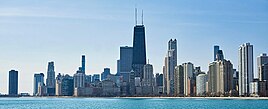
Illinois is a state in the Midwestern region of the United States. It borders Lake Michigan to its northeast, the Mississippi River to its west, and the Wabash and Ohio rivers to its south. Of the fifty U.S. states, Illinois has the fifth-largest gross domestic product (GDP), the sixth-largest population, and the 25th-most land area. Its largest urban areas include Chicago and the Metro East of Greater St. Louis, as well as Peoria, Rockford, Champaign–Urbana, and Springfield, the state's capital.

<span class="mw-page-title-main">Michigan</span> U.S. state

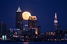
Michigan is a state in the Great Lakes region of the Upper Midwestern United States. It borders Wisconsin to the northwest in the Upper Peninsula, and Indiana and Ohio to the south in the Lower Peninsula; it is also connected by Lakes Superior, Michigan, Huron, and Erie to Minnesota and Illinois, and the Canadian province of Ontario. With a population of nearly 10.12 million and an area of 96,716 sq mi (250,490 km2), Michigan is the 10th-largest state by population, the 11th-largest by area, and the largest by area east of the Mississippi River. Its capital is Lansing, and its largest city is Detroit. Metro Detroit is among the nation's most populous and largest metropolitan economies. The name derives from a gallicized variant of the original Ojibwe word ᒥᓯᑲᒥ, meaning "large water" or "large lake".

<span class="mw-page-title-main">Kenosha County, Wisconsin</span> County in Wisconsin, United States

Kenosha County is located in the southeastern corner of the U.S. state of Wisconsin. The population was 169,151 as of the 2020 census, making it the eighth most populous county in Wisconsin. The county shares the same name as the city of Kenosha, the fourth largest city in Wisconsin. Kenosha County is part of the Chicago metropolitan area, the fourth most-populous metropolitan area in North America. Kenosha County is situated on the southwestern shore of Lake Michigan.

<span class="mw-page-title-main">Missaukee County, Michigan</span> County in Michigan, United States

Missaukee County is a county located in the U.S. state of Michigan. As of the 2020 census, the population was 15,052. The county seat is Lake City.

<span class="mw-page-title-main">Lenawee County, Michigan</span> County in Michigan, United States

Lenawee County is a county located in the U.S. state of Michigan. As of the 2020 United States Census, the population was 99,423. The county seat is Adrian. The county was created in 1822, from territory partitioned from Monroe County. Its governing structure was organized in 1826.

<span class="mw-page-title-main">Lapeer County, Michigan</span> County in Michigan, United States

Lapeer County is a county located in the U.S. state of Michigan. As of the 2020 Census, the population was 88,619. The county seat is Lapeer. The county was created on September 18, 1822, and was fully organized on February 2, 1835. The name is a corruption of the French la pierre, which means "the stone". Lapeer County is located north of Detroit and east of Flint.

<span class="mw-page-title-main">Elkhart County, Indiana</span> County in Indiana, United States

Elkhart County is a county located in the U.S. state of Indiana. As of 2020, the county's population was 207,047. The county seat is Goshen. Elkhart County is part of the Elkhart-Goshen Metropolitan Statistical Area, which in turn is part of the South Bend-Elkhart-Mishawaka Combined Statistical Area. It is also considered part of the broader region of Northern Indiana known as Michiana, and is 20 miles (32 km) east of South Bend, Indiana, 110 miles (180 km) east of Chicago, Illinois, and 150 miles (240 km) north of Indianapolis, Indiana. The area is referred to by locals as the recreation vehicle (RV) capital of the world and is known for its sizable Amish and Old Order Mennonite population.

<span class="mw-page-title-main">Midwestern United States</span> One of the four census regions of the United States

The Midwestern United States, also referred to as the Midwest or the American Midwest, is one of four census regions of the United States Census Bureau. It occupies the northern central part of the United States. It was officially named the North Central Region by the U.S. Census Bureau until 1984. It is between the Northeastern United States and the Western United States, with Canada to the north and the Southern United States to the south.

<span class="mw-page-title-main">Upper Midwest</span> Region in the northern portion of the Midwestern United States

The Upper Midwest is a region in the northern portion of the U.S. Census Bureau's Midwestern United States. It is largely a sub-region of the Midwest. Although the exact boundaries are not uniformly agreed-upon, the region is usually defined to include the states of Michigan, Minnesota and Wisconsin; some definitions include Iowa, North Dakota, South Dakota, and parts of Nebraska and Montana as well.

<span class="mw-page-title-main">Eastern United States</span> Geographic region

The Eastern United States, often abbreviated as simply the East, is a macroregion of the United States located to the east of the Mississippi River. It includes 26 states and Washington, D.C., the national capital.

<span class="mw-page-title-main">West North Central states</span> Group of states in the Central North-western part of the US

The West North Central states form one of the nine geographic subdivisions within the United States that are officially recognized by the U.S. Census Bureau.

<span class="mw-page-title-main">Central United States</span> Geographical region of the United States

The Central United States is sometimes conceived as between the Eastern and Western as part of a three-region model, roughly coincident with the U.S. Census's definition of the Midwestern United States plus the western and central portions of the U.S. Census's definition of the Southern United States. The Central States are typically considered to consist of North Dakota, South Dakota, Nebraska, Kansas, Oklahoma, Texas, Minnesota, Iowa, Missouri, Arkansas, Louisiana, Wisconsin, Illinois, Michigan, Indiana, Ohio, Kentucky, Tennessee, West Virginia, Mississippi and Alabama.

<span class="mw-page-title-main">Northern Indiana</span> Geographic and cultural region of Indiana, United States

Northern Indiana is a geographic and cultural region that generally comprises the northern third of the U.S. state of Indiana and borders the states of Illinois to the west, Michigan to the north, and Ohio to the east. Spanning the state's northernmost 26 counties, its main population centers include Northwest Indiana, Michiana, and the Fort Wayne metropolitan area.

<span class="mw-page-title-main">Northern Illinois</span> Region in the U.S. state of Illinois

Northern Illinois is a region generally covering the northern third of the U.S. state of Illinois. The region is by far the most populous of Illinois with nearly 9.7 million residents as of 2010.

<span class="mw-page-title-main">Geography of Wisconsin</span> Physical features of the state in the Midwestern United States

Wisconsin, a state in the Midwestern United States, has a vast and diverse geography famous for its landforms created by glaciers during the Wisconsin glaciation 17,000 years ago. The state can be generally divided into five geographic regions—Lake Superior Lowland, Northern Highland, Central Plain, Eastern Ridges & Lowlands, and Western Upland. The southwestern part of the state, which was not covered by glaciers during the most recent ice age, is known as the Driftless Area. The Wisconsin glaciation formed the Wisconsin Dells, Devil's Lake, and the Baraboo Range. A number of areas are protected in the state, including Devil's Lake State Park, the Apostle Islands National Lakeshore, and the Chequamegon–Nicolet National Forest.

<span class="mw-page-title-main">Great Lakes megalopolis</span> Cities around the Great Lakes of North America

The Great Lakes megalopolis consists of a bi-national group of metropolitan areas in North America largely in the Great Lakes region. It extends from the Midwestern United States in the south and west to western Pennsylvania and Western New York in the east and northward through Southern Ontario into southwestern Quebec in Canada. It is the most populated and largest megalopolis in North America.

<span class="mw-page-title-main">Outline of Illinois</span> Overview of and topical guide to Illinois

The following outline is provided as an overview of and topical guide to the U.S. state of Illinois:

<span class="mw-page-title-main">Outline of Michigan</span> Overview of and topical guide to Michigan

The following outline provides an overview of and topical guide to the U.S. state of Michigan:

<span class="mw-page-title-main">Outline of Wisconsin</span> Overview of and topical guide to Wisconsin

The following outline is provided as an overview of, and a topical guide to, the U.S. state of Wisconsin:

References

  1. "Geographic Levels". U.S. Census Bureau. Retrieved 2023-05-16.
  2. 1 2 "The Eight US States Located in the Great Lakes Region". WorldAtlas. 2020-08-27. Retrieved 2023-05-16.
  3. "Table 4". FBI.
  4. "2020 Congregational Membership". Association of Religion Data Archives. Retrieved 2023-05-16.
  5. "French Explorers and Colonists in the Illinois Country · The History of Southern Illinois · SCRC Virtual Museum at Southern Illinois University's Morris Library". scrcexhibits.omeka.net. Retrieved 2023-05-16.
  6. "iht1110409.html - Illinois as a French Colony". Northern Illinois University. Retrieved 2023-05-16.
  7. "A Brief History of Michigan" (PDF). Michigan State Legislature. 2001. Retrieved 2023-05-16.
  8. Bureau, U.S. Census. "American FactFinder – Results". Archived from the original on 2015-01-04.
  9. "2020 Census Apportionment Results". U.S. Census Bureau. Retrieved 2023-05-16.
  10. "Census: Wisconsin retains its 8 seats in Congress as South gains, Midwest loses". Wisconsin State Journal. 2021-04-29. Retrieved 2023-05-16.
  11. "American FactFinder – Results". Archived from the original on 2014-03-05. Retrieved 2012-02-25.
  12. "Data Center Results". Archived from the original on 2013-08-15. Retrieved 2013-08-10.
  13. "Amish Country and Holmes County | Ohio | Press Room | Fact Sheets". Archived from the original on 2011-12-30. Retrieved 2012-07-29.