The following is an alphabetical list of the islands and cays of the Commonwealth of The Bahamas . [1] [2] [3]
The following is an alphabetical list of the islands and cays of the Commonwealth of The Bahamas . [1] [2] [3]

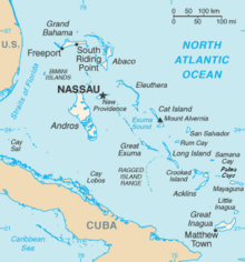
The Bahamas are a group of about 700 islands and cays in the western Atlantic Ocean, of which only between 30 and 40 are inhabited. The largest of the islands is Andros Island, located north of Cuba and 200 kilometres southeast of Florida. The Bimini islands are to its northwest. To the North is the island of Grand Bahama, home to the second-largest city in the country, Freeport. The island of Great Abaco is to its east. In the far south is the island of Great Inagua, the second-largest island in the country. Other notable islands include Eleuthera, Cat Island, San Salvador Island, Acklins, Crooked Island, and Mayaguana. Nassau is the capital and largest city, located on New Providence. The islands have a tropical savannah climate, moderated by the Gulf Stream. The total size is 13,878 km2 (5,358 sq mi). Due to the many widespread islands it has the 41st largest Exclusive Economic Zone of 654,715 km2 (252,787 sq mi).
This article talks about transportation in the Bahamas, a North American archipelagic state in the Atlantic Ocean.
The Lucayan people were the original residents of The Bahamas before the European colonisation of the Americas. They were a branch of the Taínos who inhabited most of the Caribbean islands at the time. The Lucayans were the first indigenous Americans encountered by Christopher Columbus. Shortly after contact, the Spanish kidnapped and enslaved Lucayans, with the displacement culminating in the complete eradication of the Lucayan people from the Bahamas by 1520.
The Berry Islands are a chain of islands and a district of the Bahamas, covering about thirty square miles (78 km2) of the northwestern part of the Out Islands.

Local government in The Bahamas exists at two levels: 32 districts and 41 towns. The boundaries of districts are defined by the First Schedule of The Bahamas Local Government Act 1996, defined with reference to parliamentary constituency boundaries. The Second Schedule lists 13 districts which are divided into town areas. Towns are governed by directly elected town committees. Second Schedule districts are governed by nine-person district councils composed of the chairs of the town committees, and if numerically required, additional people elected by the town committees. The 19 Third Schedule districts are unitary authorities which cannot be divided into towns. They are governed by nine-person district councils which are directly elected by voters. The powers of Second Schedule and Third Schedule councils are slightly different, and the Third Schedule district known as the City of Freeport has a slightly different list of enumerated powers.

The Abaco Islands lie in the northern Bahamas, located about 193 miles east of Miami, Florida. The main islands are Great Abaco and Little Abaco, which is located just west of the northern tip of Great Abaco. There are several smaller barrier cays, of which the northernmost are Walker's Cay and its sister island Grand Cay. To the south, the next inhabited islands are Spanish Cay and Green Turtle Cay, with its settlement of New Plymouth, Great Guana Cay, private Scotland Cay, Man-O-War Cay, and Elbow Cay, with its settlement of Hope Town. Southernmost are Tilloo Cay and Lubbers Quarters. Another of note off Abaco's western shore is Gorda Cay, now a Disney-owned island and a cruise ship stop renamed Castaway Cay. Also in the vicinity is Moore's Island. On the Big Island of Abaco is Marsh Harbour, the Abacos' commercial hub and the Bahamas' third largest city, plus the resort area of Treasure Cay. Both have airports. A few mainland settlements of significance are Coopers Town and Fox Town in the north and Cherokee and Sandy Point in the south. Administratively, the Abaco Islands constitute seven of the 31 Local Government Districts of the Bahamas: Grand Cay, North Abaco, Green Turtle Cay, Central Abaco, South Abaco, Moore's Island, and Hope Town.
A private island is a disconnected body of land wholly owned by a private citizen or corporation. Although this exclusivity gives the owner substantial control over the property, private islands remain under the jurisdiction of national and sometimes local governments. Their size can vary widely, from that of a typical suburban yard to several hundred square kilometers.

Exuma is a district of The Bahamas, consisting of over 365 islands and cays.

Ragged Island is a 23 km2 (8.9 sq mi) island and district in the southern Bahamas. Ragged Island is part of the Jumentos Cays and Ragged Island Chain. The crescent-shaped chain measures over 180 km (110 mi) in length and includes cays known as Raccoon Cay, Hog Cay and Double-Breasted Cay. Island ownership is stated to have been granted to William George Lockhart some time in the 18th century. On 8 September 2017, Duncan Town took a direct hit from Hurricane Irma.

Great Guana Cay is an islet in The Bahamas. It is a long, narrow islet, 7 miles (11 km) long. It is in the centre of the Abaco Islands and is near Gumelemi Cay. It is about 8 miles from Marsh Harbour. Approximately 150 people live on the island, mostly along the five and a half mile long stretch of beach.
Flamingo Air is a small airline in the Bahamas. Its base of operations is the Grand Bahama International Airport in Freeport. It also has offices in Marsh Harbour Abaco Airport, in Bimini International Airport, and in the Lynden Pindling International Airport, Nassau. It provides scheduled service to several islands, as well as Air Charter service to the Bahamas and south Florida. The airline is currently grounded after a number of incidents in recent years. The Bahamian authorities have said they will keep all the aircraft grounded until inspections of Flamingo Air's maintenance and investigation into their safety practices are completed.

The effects of Hurricane Andrew in the Bahamas included three direct fatalities and $250 million (1992 USD) in damage. Forming from a tropical wave on August 16, Andrew remained weak until rapidly intensifying on August 22, and late on August 23 it made its first landfall in The Bahamas on Eleuthera as a Category 5 hurricane with winds of 260 km/h (160 mph); early the next day Hurricane Andrew passed through the southern Berry Islands with winds of 240 km/h (150 mph). The hurricane later made a devastating landfall in southern Florida, and after striking southern Louisiana it dissipated over the eastern United States. Andrew was the first major hurricane to affect the nation since Hurricane Betsy in 1965. It caused $250 million in damage, with damage heaviest on Eleuthera and Cat Cay. Four deaths occurred due to the storm, of which one was indirectly related to the hurricane.

The following outline is provided as an overview of and topical guide to The Bahamas:
The Bahamas National Trust is a non-profit organisation in the Bahamas that manages the country's 32 national parks. Its headquarters is located in New Providence in the Bay Street Business Centre, East Bay Street. Its office was formally located at The Retreat Gardens on Village Road. The Bahamas National Trust was created by an Act of Parliament in 1959, through the efforts of two groups of conservationists.

The following is an alphabetical list of topics related to the Commonwealth of The Bahamas.

The Sea of Abaco, located in The Bahamas, is an approximately 100 kilometres long saltwater lagoon separating Great Abaco Island from a chain of barrier islands known as the Abaco Cays. Depths in the Sea of Abaco are generally a few metres, and shallow reefs and shoals can pose a serious hazard to navigation. Despite these hazards, the sea is popular with boaters and is sometimes referred to as a 'marine highway', offering a sheltered passage through the Abaco Islands. The majority of the largest settlements and towns in the Abaco Islands are located along the shores of the sea.

Long Island is an island in The Bahamas that is split by the Tropic of Cancer. It is one of the Districts of the Bahamas and is known as the most scenic island in the Bahamas. Its capital is Clarence Town. The population of Long Island is 3,094 inhabitants.
Hog Cay may refer to:

Chilabothrus strigilatus, also known commonly as the Bahamian boa, is a species of snake in the family Boidae. The species is endemic to the Bahamas. There are five recognized subspecies.