
The following is a list of reservoirs and lakes in the U.S. state of Texas. Swimming, fishing, and/or boating are permitted in some of these lakes, but not all.
The following is a list of reservoirs and lakes in the U.S. state of Texas. Swimming, fishing, and/or boating are permitted in some of these lakes, but not all.


| States |
|
|---|---|
| Federal district | |
| Territories | |
| Bays and estuaries of the Gulf of Mexico |
|
|---|---|
| Channels and canals | |
| Lakes and reservoirs |
|
| Rivers |
|
| Wetlands | |
Austin (capital) | |
| Topics | |
| Society | |
| Regions |
|
| Metropolitan areas |
|
| Counties | |
| Authority control databases: National |
|---|

Palo Pinto County is a county located in the U.S. state of Texas. As of the 2020 census, its population was 28,409. The county seat is Palo Pinto. The county was created in 1856 and organized the following year.

Cleburne is a city in and the county seat of Johnson County, Texas, United States. As of the 2020 census, its population was 31,352. The city is named in honor of Patrick Cleburne, a Confederate general. Lake Pat Cleburne, the reservoir that provides water to the city and surrounding area, is also named after him.

The Red River, or sometimes the Red River of the South to differentiate it from the Red River in the north of the continent, is a major river in the Southern United States. It was named for its reddish water color from passing through red-bed country in its watershed. It is known as the Red River of the South to distinguish it from the Red River of the North, which flows between Minnesota and North Dakota into the Canadian province of Manitoba. Although once a tributary of the Mississippi River, the Red River is now a tributary of the Atchafalaya River, a distributary of the Mississippi that flows separately into the Gulf of Mexico. This confluence is connected to the Mississippi River by the Old River Control Structure.

The Texas panhandle is a region of the U.S. state of Texas consisting of the northernmost 26 counties in the state. The panhandle is a square-shaped area bordered by New Mexico to the west and Oklahoma to the north and east. It is adjacent to the Oklahoma Panhandle, land which Texas previously claimed. The 1820 Missouri Compromise declared no slavery would be allowed in states admitted from the Louisiana Purchase above 36°30′ north latitude. Texas was annexed in 1845 from still more westerly land. The Compromise of 1850 removed territory north of this line from Texas, and set the border between the Texas Panhandle and the New Mexico Territory at the 103rd meridian west. The eastern border at the 100th meridian west was inherited from the Adams–Onís Treaty of 1819, which defined the border between the United States and New Spain. The Handbook of Texas defines the southern border of Swisher County as the southern boundary of the Texas Panhandle region.

The Trinity River is a 710-mile (1,140 km) river, the longest with a watershed entirely within the U.S. state of Texas. It rises in extreme northern Texas, a few miles south of the Red River. The headwaters are separated by the high bluffs on the southern side of the Red River.
Lake Ray Hubbard, formerly Eastern Dallas Lake or Forney Lake, is a freshwater impoundment (reservoir) located in Dallas, Texas in the counties of Dallas, Kaufman, Collin, and Rockwall, just north of the City of Forney. It was created by the construction of the Rockwall-Forney Dam, which impounded the East Fork Trinity River.

Possum Kingdom State Park is a state park in Palo Pinto County, Texas, USA, that was built in the 1940s by Civilian Conservation Corps Company 2888 and opened to the public in 1950. It covers approximately 1,530 acres (620 ha), and lies in the Palo Pinto Mountains and Brazos River Valley of Texas. The park borders the large Possum Kingdom Lake, a 20,000-acre (8,100 ha) lake known for its clear blue waters. Possum Kingdom winds for 65 miles (105 km) down the Brazos River, and has more than 300 miles (480 km) of shoreline. A privately owned store and marina in the park cater to boaters and campers.

Lake Mineral Wells State Park & Trailway is a state park located in Mineral Wells, Parker County, Texas. It includes Lake Mineral Wells, and is the only state park in Texas which protects part of the Western Cross Timbers and Mineral Wells Trailway. Also within the park is Penitentiary Hollow, a somewhat unusual geological feature which resembles a small canyon. It is a popular site for rock climbing, though the only type of climbing allowed is top-rope. The park also features over 31 miles (50 km) of hiking trails, 25 miles (40 km) of which are open to bicycles and horses. Campsites can be found by the small lake, and up on the higher areas of the park, as well.

Victor Braunig Lake, formerly known as East Lake, is a reservoir on Calaveras Creek and Chupaderas Creek 17 miles south of Downtown San Antonio, Texas, USA. The reservoir was formed in 1962 by the construction of a dam to provide a cooling pond for a power plant to supply additional electrical supply to the city of San Antonio. Victor Braunig (1890-1982) was an employee from 1910 becoming in 1949 the general manager of the San Antonio City Public Service Board, the predecessor of CPS Energy. The dam and lake are managed by CPS Energy of San Antonio. Together with Calaveras Lake, Braunig Lake was one of the first projects in the nation to use treated wastewater for power plant cooling. The reservoir is partly filled with wastewater that has undergone both primary and secondary treatment at a San Antonio Water System treatment plant. Braunig Lake also serves as a venue for recreation, including fishing and boating.

Possum Kingdom Lake, is a reservoir on the Brazos River located primarily in Palo Pinto County Texas. It was the first water supply reservoir constructed in the Brazos River basin. The lake has an area of approximately 17,000 acres (6,900 ha) with 310 miles (500 km) of shoreline. It holds 750,000 acre-feet (930,000,000 m3) of water with 550,000 acre-feet (680,000,000 m3) available for water supply.

Lake Pat Cleburne is the municipal water reservoir for the city of Cleburne, Texas, as well as a recreational lake for residents. It is formed by damming the Nolan River which continues below the lake's dam. The water is murky due to sediment. U.S. Highway 67 crosses over the extreme north end of the lake lending a panoramic view of the complete lake.

U.S. Route 67 is a major U.S. highway in the state of Texas. It runs from the U.S.–Mexico border west of Presidio to Texarkana at the Arkansas state line. US 67 is part of the La Entrada al Pacifico international trade corridor from its southern terminus to US 385 in McCamey.
The term Palo Pinto Mountains properly refers to a specific cuesta-like range of hills in western Palo Pinto County, Texas. The name Palo Pinto roughly translates to "painted stick" in reference to the juniper trees of the area. Isolated, rugged, and scenic, the ridge extends some 15 miles, from near the intersection of Texas State Highway 16 and Farm to Market Road 207 in the southwest, to Crawford Mountain just south of the Fortune Bend on the Brazos River in the northeast.
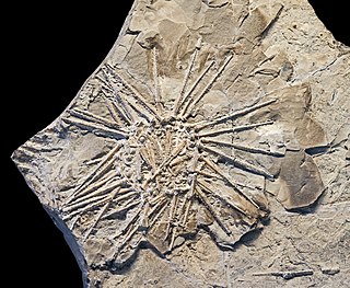
The Canyon Group is a geologic group in Texas. It preserves fossils dating back to the Carboniferous period. It contains the Caddo Creek, Graford, Palo Pinto, Wolf Mountain Shale and Winchell Formations.

Park Road 36 (PR 36) is a 5.606-mile-long (9.022 km) Park Road in the U.S. state of Texas maintained by the Texas Department of Transportation (TxDOT). The road, located in northwestern Palo Pinto County west of Graford, was authorized in 1945 to provide access to a former section of Possum Kingdom State Park. PR 36 has since been extended to two private campgrounds connecting them to State Highway 16 (SH 16) while intersecting FM 2951 and FM 2353.
Possum Kingdom or Possum Kingdom Lake is a reservoir in Palo Pinto County, Texas.
Palo Pinto Creek Reservoir is a lake located south of Palo Pinto, and north-east of Gordon in Palo Pinto County, Texas. The eastern branch of the reservoir is known as Lake Palo Pinto.
