Calhoun County is a county located in the U.S. state of Texas. As of the 2020 census, the population was 20,106. Its county seat is Port Lavaca. The county is named for John Caldwell Calhoun, the seventh vice president of the United States. Calhoun County comprises the Port Lavaca, TX Micropolitan Statistical Area, which is also included in the Victoria-Port Lavaca, TX Combined Statistical Area.
Port Aransas is a city in Nueces County, Texas, United States. This city is 180 miles southeast of San Antonio. The population was 2,904 at the 2020 census. Port Aransas is the only established town on Mustang Island. It is located north of Padre Island and is one of the longest barrier islands along the Texas coast. Corpus Christi Bay, the Gulf of Mexico, the Lydia Ann Ship Channel, and the Corpus Christi Ship Channel make up the surrounding waters.

René-Robert Cavelier, Sieur de La Salle, was a 17th-century French explorer and fur trader in North America. He explored the Great Lakes region of the United States and Canada, and the Mississippi River. He is best known for an early 1682 expedition in which he canoed the lower Mississippi River from the mouth of the Illinois River to the Gulf of Mexico; there, on 9 April 1682, he claimed the Mississippi River basin for France after giving it the name La Louisiane. One source states that "he acquired for France the most fertile half of the North American continent". A later ill-fated expedition to the Gulf coast of Mexico gave the United States a claim to Texas in the purchase of the Louisiana Territory from France in 1803. La Salle was assassinated in 1687 during that expedition.

Indianola is a ghost town located on Matagorda Bay in Calhoun County, Texas, United States. The community, once the county seat of Calhoun County, is a part of the Victoria, Texas, Metropolitan Statistical Area. In 1875, the city had a population of 5,000, but on September 15 of that year, a powerful hurricane struck, killing between 150 and 300 and almost entirely destroying the town. Indianola was rebuilt, only to be wiped out on August 19, 1886, by another intense hurricane, which was followed by a fire. Indianola was designated a Recorded Texas Historic Landmark in 1963, marker number 2642.

Lavaca Bay is a northwestern extension of the Matagorda Bay system found mostly in Calhoun County, Texas, United States. The ports of Port Lavaca and Point Comfort have been established on the bay, and are the main areas of human habitation. Linnville was located on the bay until its abandonment after the Great Raid of 1840, and the major port of Indianola was found near the confluence with the main Matagorda Bay, until the town's final destruction following the massive hurricane of 1886. Smaller communities include Olivia, Alamo Beach and Magnolia Beach. Lavaca Bay is approximately 82 miles (130 km) northeast of Corpus Christi, about 121 miles (190 km) southwest of Houston, and 145 miles (230 km) southeast of San Antonio.

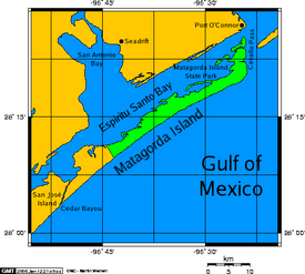
Matagorda Bay is a large Gulf of Mexico bay on the Texas coast, lying in Calhoun and Matagorda counties and located approximately 80 miles (130 km) northeast of Corpus Christi, 143 miles (230 km) east-southeast of San Antonio, 108 miles (174 km) south-southwest of Houston, and 167 miles (269 km) south-southeast of Austin. It is one of seven major estuaries along the Gulf Coast of Texas and serves as the mouth of numerous streams, most notably the Lavaca and Colorado Rivers. The Texas seaport of Port Lavaca is located on the system's northwestern extension of Lavaca Bay. The city of Palacios is found on northeastern extension of Tres Palacios Bay, and Port O'Connor is located on the southwestern tip of the main bay's shore. The ghost town of Indianola, which was a major port before it was destroyed by two hurricanes in the late 19th century, is also found on the bay.

USS Sciota was a Unadilla-class gunboat built on behalf of the United States Navy for service during the Civil War. She was outfitted as a gunboat, with both a 20-pounder rifle for horizontal firing, and two howitzers for shore bombardment, and assigned to the Union blockade of the waterways of the Confederate States of America.

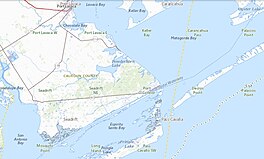
Matagorda Island, Spanish for "thick bush," is a 38-mile (61 km) long barrier island on the Texas Gulf coast, located approximately seven miles south of Port O'Connor, in the southernmost part of Calhoun County. The traditional homeland of the Karankawa people, the island is oriented generally northeast-southwest, with the Gulf of Mexico on the east and south, and Espiritu Santo Bay on the west and north. It is separated from San José Island to the south by Cedar Bayou, and is separated from the Matagorda Peninsula to the north by Pass Cavallo. It is accessible by boat only. It has a land area of 60.7 square miles.

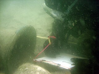
La Belle was one of Robert de La Salle's four ships when he explored the Gulf of Mexico with the ill-fated mission of starting a French colony at the mouth of the Mississippi River in 1685. La Belle was wrecked in present-day Matagorda Bay the following year, dooming La Salle's Texas colony to failure. The wreckage of La Belle lay forgotten until it was discovered by a team of state archaeologists in 1995. The discovery of La Salle's flagship was regarded as one of the most important archaeological finds of the century in Texas, and a major excavation was launched by the state of Texas that, over a period of about a year, recovered the entire shipwreck and over a million artifacts.

Corpus Christi Bay is a scenic semi-tropical bay on the Texas coast found in San Patricio and Nueces counties, next to the major city of Corpus Christi. It is separated from the Gulf of Mexico by Mustang Island, and is fed by the Nueces River and Oso Creek from its western and southern extensions, Nueces Bay and Oso Bay. The bay is located approximately 136 miles (219 km) south of San Antonio, and 179 miles (288 km) southwest of Houston.

San Antonio Bay is a bay on the Texas Gulf Coast situated between Matagorda and Aransas Bay. It consists mainly of the combined waters of the San Antonio and Guadalupe rivers, and is located at the mouth of the Guadalupe River, about 55 miles (89 km) northeast of Corpus Christi and 130 miles (209 km) southeast of San Antonio. It is protected from the Gulf of Mexico by Matagorda Island, leaving only relatively small and distant outlets to the Gulf for little mixing of bay and Gulf waters. The remoteness of the bay has prevented the establishment of major ports as seen on Aransas Bay and Corpus Christi Bay, to the south.

The French colonization of Texas began with the establishment of a fort in present-day southeastern Texas. Fort Saint Louis was established in 1685 near Arenosa Creek and Matagorda Bay by explorer Robert Cavelier de La Salle. He intended to found the colony at the mouth of the Mississippi River, but inaccurate maps and navigational errors caused his ships to anchor instead 400 miles (640 km) to the west, off the coast of Texas. The colony survived until 1688. The present-day town of Inez is near the fort's site. The colony faced numerous difficulties during its brief existence, including Native American raids, epidemics, and harsh conditions. From that base, La Salle led several expeditions to find the Mississippi River. These did not succeed, but La Salle did explore much of the Rio Grande and parts of east Texas.
USS Arthur was a bark acquired by the Union Navy during the American Civil War. She was used by the Union Navy as a gunboat in support of the Union Navy blockade of Confederate waterways.

Texas Gulf Coast is an intertidal zone which borders the coastal region of South Texas, Southeast Texas, and the Texas Coastal Bend. The Texas coastal geography boundaries the Gulf of Mexico encompassing a geographical distance relative bearing at 367 miles (591 km) of coastline according to CRS and 3,359 miles (5,406 km) of shoreline according to NOAA.
Espiritu Santo Bay is a northeastern extension of San Antonio Bay in Calhoun County, Texas. It is separated from Matagorda Bay by a line of barrier islands that run south from Port O'Connor to Matagorda Island.

The Matagorda Ship Channel is a channel constructed between 1962 and 1966 that allows ocean-going vessels to travel between the Gulf of Mexico and Matagorda Bay. The channel is part of the Port of Port Lavaca – Point Comfort, a major sea port in the U.S. state of Texas.
Charles T. Meide Jr., known as Chuck Meide, is an underwater and maritime archaeologist and currently the Director of LAMP, the research arm of the St. Augustine Lighthouse & Maritime Museum located in St. Augustine, Florida. Meide, of Syrian descent on his father's side, was born in Jacksonville, Florida, and raised in the nearby coastal town of Atlantic Beach. He earned BA and MA degrees in Anthropology with a focus in underwater archaeology in 1993 and 2001 from Florida State University, where he studied under George R. Fischer, and undertook Ph.D. studies in Historical Archaeology at the College of William and Mary starting the following year. Meide has participated in a wide array of shipwreck and maritime archaeological projects across the U.S., especially in Florida, and throughout the Caribbean and Bermuda and in Australia and Ireland. From 1995 to 1997 he participated in the search for, discovery, and total excavation of La Salle's shipwreck, La Belle , lost in 1686. From December 1997 to January 1998 he served as Co-Director of the Kingstown Harbour Shipwreck Project, an investigation sponsored by the Institute of Maritime History and Florida State University into the wreck of the French frigate Junon (1778) lost in 1780 in St. Vincent and the Grenadines. In 1999 he directed the Dog Island Shipwreck Survey, a comprehensive maritime survey of the waters around a barrier island off the coast of Franklin County, Florida, and between 2004 and 2006 he directed the Achill Island Maritime Archaeology Project off the coast of County Mayo, Ireland. Since taking over as Director of LAMP in 2006, he has directed the First Coast Maritime Archaeology Project, a state-funded research and educational program focusing on shipwrecks and other maritime archaeological resources in the offshore and inland waters of Northeast Florida. In 2009, during this project, Meide discovered the "Storm Wreck," a ship from the final fleet to evacuate British troops and Loyalist refugees from Charleston at the end of the Revolutionary War, which wrecked trying to enter St. Augustine in late December 1782. He led the archaeological excavation of this shipwreck site each summer from 2010 through 2015, overseeing the recovery of thousands of well-preserved artifacts.

The Halfmoon Reef Light is one of the many screw-pile type lighthouses built on the Texas Gulf Coast, but the only one that still stands. To distinguish it from the nearby Matagorda Island Light it was given a red glass chimney to be used with the oil lantern to give it its red beam. Though originally constructed on the bay, the current resting place for the light is on Port Lavaca, alongside Highway 35.

The Matagorda Island Light is located on Matagorda Island in Calhoun County, in the U.S. state of Texas. Once under the jurisdiction of the United States Coast Guard, the lighthouse is now managed by the Texas Parks and Wildlife Department.

The U.S. state of Texas has a series of estuaries along its coast on the Gulf of Mexico, most of them bounded by the Texas barrier islands. Estuaries are coastal bodies of water in which freshwater from rivers mixes with saltwater from the sea. Twenty-one drainage basins terminate along the Texas coastline, forming a chain of seven major and five minor estuaries: listed from southwest to northeast, these are the Rio Grande Estuary, Laguna Madre, the Nueces Estuary, the Mission–Aransas Estuary, the Guadalupe Estuary, the Colorado–Lavaca Estuary, East Matagorda Bay, the San Bernard River and Cedar Lakes Estuary, the Brazos River Estuary, Christmas Bay, the Trinity–San Jacinto Estuary, and the Sabine–Neches Estuary. Each estuary is named for its one or two chief contributing rivers, excepting Laguna Madre, East Matagorda Bay, and Christmas Bay, which have no major river sources. The estuaries are also sometimes referred to by the names of their respective primary or central water bodies, though each also includes smaller secondary bays, inlets, or other marginal water bodies.