Today, as was also true in the past, there is a wide range of opinion as to what differentiated a plantation from a farm. Typically, the focus of a farm was subsistence agriculture. In contrast, the primary focus of a plantation was the production of cash crops, with enough staple food crops produced to feed the population of the estate and the livestock.[4] A common definition of what constituted a plantation is that it typically had 500 to 1,000 acres (2.0 to 4.0km2) or more of land and produced one or two cash crops for sale.[5] Other scholars have attempted to define it by the number of slaves that were owned.[6]
North Carolina plantations
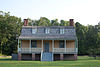
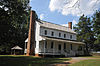
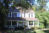
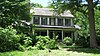
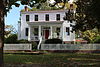
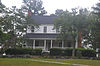
The tables of plantations below are sortable, so the name, locality, county (current), historic register number, and built in years can be easily reviewed. References can be found on the individual articles linked or are noted if there are no articles. Comparisons to similar referenced listings are in progress.[7][8][9]
Color key
Historic register listing
National Historic Landmark
National Register of Historic Places
Contributing property to a National Register of Historic Places historic district
Not listed on national or state register
Built during the Province of North Carolina period
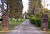
North Carolina plantation were identified by name, beginning in the 17th century. The names of families or nearby rivers or other features were used. The names assisted the owners and local record keepers in keeping track of specific parcels of land. In the early 1900s, there were 328 plantations identified in North Carolina from extant records.[10][8][9]
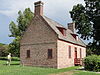
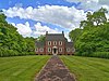
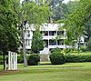
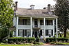
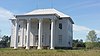
The Sloop Point plantation in Pender County, built in 1729, is the oldest surviving plantation house and the second oldest house surviving in North Carolina, after the Lane House (built in 1718–1719 and not part of a plantation). Sloop Point was once owned by John Baptista Ashe, who was a delegate to the Continental Congress, U.S. Congressman from North Carolina and Continental Army officer.[11][12]
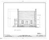
The known plantations during the period of the Province of North Carolina (1712–1776) are listed in the table below.
The following persons were large plantation owners for which the plantation has not yet been identified.
John H. Wheeler: (1806–1882) was an American planter, slaveowner, attorney, politician and historian who served as North Carolina State Treasurer (1843–1845) and as United States Minister to Nicaragua (1855–1856)
William Lenoir: (May 8, 1751 – May 6, 1839) was an American Revolutionary War officer and prominent statesman in late 18th-century and early 19th-century North Carolina.
Originally form Virginia the J.A. Evans Family moved from Edgecombe County, N.C. through Nash County, N.C. to Pine Level in Johnston County, N.C. in 1850 A.D. and started a farm which eventually through land purchases became the 6,000 acre Tall Pines Plantation, Founded in 1870 A.D. by Jane Barns Evans widow of J.A. Evans CSA. The family lost control of the property in 1938 A.D. after the Great Financial Depression and gained some compensation for the land through legal action taking by the Evans family in 1947 A.D. Descendants of the J.A. Evans Family in 2020 A.D. were still living in the Pine Level area.
Jane Barnes Evans was a cotton Baroness and part owner of the North Carolina Railroad which ran through part of her Tall Pines Plantation which supplied fresh water to the North Carolina Railroad for the use of steam engine locomotives.
Related Research Articles
Duplin County is a county located in the U.S. state of North Carolina. As of the 2020 census, the population was 48,715. Its county seat is Kenansville.
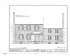
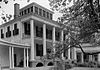
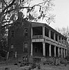
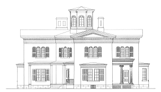
Cooleemee, also known as the Cooleemee Plantation House, is a house located between Mocksville and Lexington, North Carolina, at the terminus of SR 1812 on the Yadkin River in Davie County, North Carolina. It is a U.S. National Historic Landmark, designated in 1978 for its architecture.
This is a list of structures, sites, districts, and objects on the National Register of Historic Places in North Carolina:
This list includes properties and districts listed on the National Register of Historic Places in Wake County, North Carolina. Click the "Map of all coordinates" link to the right to view an online map of all properties and districts with latitude and longitude coordinates in the table below.
This list includes properties and districts listed on the National Register of Historic Places in Cumberland County, North Carolina, United States. Click the "Map of all coordinates" link to the right to view a Google map of all properties and districts with latitude and longitude coordinates in the table below.
This list includes properties and districts listed on the National Register of Historic Places in Rowan County, North Carolina. Click the "Map of all coordinates" link to the right to view an online map of all properties and districts with latitude and longitude coordinates in the table below.
This list includes properties and districts listed on the National Register of Historic Places in Wilkes County, North Carolina. Click the "Map of all coordinates" link to the right to view an online map of all properties and districts with latitude and longitude coordinates in the table below.
This is a list of the National Register of Historic Places listings in Jasper County, South Carolina.
This list includes properties and districts listed on the National Register of Historic Places in Robeson County, North Carolina. Click the "Map of all coordinates" link to the right to view a Google map of all properties and districts with latitude and longitude coordinates in the table below.
This list includes properties and districts listed on the National Register of Historic Places in Brunswick County, North Carolina. Click the "Map of all coordinates" link to the right to view an online map of all properties and districts with latitude and longitude coordinates in the table below.
Sloop Point Plantation is a historic house located at Sloop Point, Pender County, North Carolina. It was built in 1729 according to dendrochronological dating and is possibly the oldest surviving framed building in the state of North Carolina. The house was built as a home for John Baptista Ashe and his wife Elizabeth Swann Ashe.
Slavery was legally practiced in the Province of North Carolina and the state of North Carolina until January 1, 1863, when President Abraham Lincoln issued the Emancipation Proclamation. Prior to statehood, there were 41,000 enslaved African-Americans in the Province of North Carolina in 1767. By 1860, the number of slaves in the state of North Carolina was 331,059, about one third of the total population of the state. In 1860, there were nineteen counties in North Carolina where the number of slaves was larger than the free white population. During the antebellum period the state of North Carolina passed several laws to protect the rights of slave owners while disenfranchising the rights of slaves. There was a constant fear amongst white slave owners in North Carolina of slave revolts from the time of the American Revolution. Despite their circumstances, some North Carolina slaves and freed slaves distinguished themselves as artisans, soldiers during the Revolution, religious leaders, and writers.
↑ Phillips, Ulrich Bonnell (1929). Life and Labor in the Old South. Boston: Little, Brown, and Company. p.338. ISBN978-0-316-70607-0.
↑ Robert J. Vejnar II (November 6, 2008). "Plantation Agriculture". The Encyclopedia of Alabama. Auburn University. Retrieved April 15, 2011.
↑ Vlach, John Michael (1993). Back of the Big House, The Architecture of Plantation Slavery. Chapel Hill: University of North Carolina Press. p.8. ISBN978-0-8078-4412-0.
This page is based on this Wikipedia article Text is available under the CC BY-SA 4.0 license; additional terms may apply. Images, videos and audio are available under their respective licenses.