Windsor, North Carolina

Last updated

Windsor, North Carolina
Windsor, North Carolina.jpg
South King Street
Windsor, NC Town Seal.jpg
NCMap-doton-Windsor.PNG
Location of Windsor, North Carolina
Coordinates: 35°59′35″N76°56′24″W / 35.99306°N 76.94000°W / 35.99306; -76.94000
Country United States
State North Carolina
County Bertie
Area
[1]
  Total2.81 sq mi (7.29 km2)
  Land2.81 sq mi (7.29 km2)
  Water0.00 sq mi (0.00 km2)
Elevation
[2]
0 ft (0 m)
Population
 (2020)
  Total3,582
  Density1,272.47/sq mi (491.22/km2)
Time zone UTC-5 (Eastern (EST))
  Summer (DST) UTC-4 (EDT)
ZIP code
27983 27959
Area code 252
FIPS code 37-74680 [3]
GNIS feature ID2406899 [2]
Website windsornc.com

Windsor is a town in Bertie County, North Carolina, United States. The population was 3,630 at the 2010 census, [4] up from 2,283 in 2000. It is the county seat of Bertie County, which is also the homeland of the Southern Band Tuscarora Tribe that remained in North Carolina post Colonialism. [5] Windsor is located in North Carolina's Inner Banks region.

Contents

History

The land was historically the home of the Tuscarora people. Today, there are Tuscarora residents living in the village of Tandequemuc, now called Merry Hill.

Bertie County Courthouse, Bertie Memorial Hospital, Elmwood, Freeman Hotel, Hope Plantation, Jordan House, King House, Liberty Hall, Rosefield, and Windsor Historic District are listed on the National Register of Historic Places. [6]

In the early morning hours of August 4, 2020, an EF3 tornado spawned by Hurricane Isaias struck areas just outside of Windsor. The twister obliterated 12 mobile homes within a mobile home park outside of town, and flattened another poorly built house. The tornado killed 2 people and injured 14 others. The tornado was the strongest tropical cyclone- spawned tornado since 2005. Governor Roy Cooper toured the damage area in the days following the event. [7] [8]

Recreation

Windsor is a notable Inner Banks kayaking destination. Canoes and kayaks are offered, by the Town of Windsor and the Roanoke Cashie River Center to use on the generally calm waters of the Cashie River. [9]

Town of Windsor Parks and Recreation Department Facilities

Tree house campground on the Cashie River in Windsor, NC Cashie River Treehouses Windsor, NC, USA.jpg
Tree house campground on the Cashie River in Windsor, NC

Geography

According to the United States Census Bureau, the town has a total area of 2.8 square miles (7.3 km2), all of it land. [4]

Demographics

Historical population
CensusPop.Note
1860 315
1870 42735.6%
1890 522
1900 59714.4%
1910 68414.6%
1920 1,21076.9%
1930 1,42517.8%
1940 1,74722.6%
1950 1,7811.9%
1960 1,8131.8%
1970 2,19921.3%
1980 2,126−3.3%
1990 2,056−3.3%
2000 2,28311.0%
2010 3,63059.0%
2020 3,582−1.3%
U.S. Decennial Census [11]

2020 census

Windsor racial composition [12]
RaceNumberPercentage
Black or African American (non-Hispanic)2,18861.08%
White (non-Hispanic)1,13731.74%
Native American 290.81%
Asian 391.09%
Other/Mixed 1093.04%
Hispanic or Latino 802.23%

As of the 2020 United States census, there were 3,582 people, 1,018 households, and 641 families residing in the town.

2000 census

As of the census [3] of 2000, there were 2,283 people, 938 households, and 605 families residing in the town. The population density was 925.6 people per square mile (357.4 people/km2). There were 1,080 housing units at an average density of 437.9 per square mile (169.1/km2). The racial makeup of the town was 52.96% African American, 45.42% White, 20.35% Native American, 2.66% Asian, 0.04% Pacific Islander, 0.13% from other races, and 0.44% from two or more races. Hispanic or Latino of any race were 0.35% of the population.

In 2006, the State of North Carolina Department of Public Safety opened the Bertie Correctional Institution on Cooper Hill Road near Windsor. BCI is a close-security prison with the capacity to house up to 1,504 inmates. The new prisoners contributed to the sudden growth in Windsor's population between the 2000 and 2010 census.

There were 938 households, out of which 28.5% had children under the age of 18 living with them, 42.2% were married couples living together, 20.3% had a female householder with no husband present, and 35.5% were non-families. 33.8% of all households were made up of individuals, and 17.0% had someone living alone who was 65 years of age or older. The average household size was 2.33 and the average family size was 2.96.

In the town, the population was spread out, with 24.8% under the age of 18, 5.5% from 18 to 24, 24.1% from 25 to 44, 24.1% from 45 to 64, and 21.4% who were 65 years of age or older. The median age was 42 years. For every 100 females, there were 75.9 males. For every 100 females age 18 and over, there were 69.9 males.

The median income for a household in the town was $25,256, and the median income for a family was $34,107. Males had a median income of $30,045 versus $20,885 for females. The per capita income for the town was $18,006. About 19.9% of families and 25.8% of the population were below the poverty line, including 35.1% of those under age 18 and 25.4% of those age 65 or over.

Notable people

Education

Related Research Articles

<span class="mw-page-title-main">Halifax County, North Carolina</span> County in North Carolina, United States

Halifax County is a county located in the U.S. state of North Carolina. As of the 2020 census, the population was 48,622. Its county seat is Halifax.

<span class="mw-page-title-main">Edgecombe County, North Carolina</span> County in North Carolina, United States

Edgecombe County is a county located in the U.S. state of North Carolina. As of the 2020 census, the population was 48,900. Its county seat is Tarboro.

<span class="mw-page-title-main">Bertie County, North Carolina</span> County in North Carolina, United States

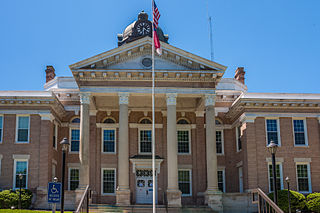
Bertie County is a county located in the northeast area of the U.S. state of North Carolina. As of the 2020 census, the population was 17,934. Its county seat is Windsor. The county was created in 1722 as Bertie Precinct and gained county status in 1739.

Tuscarora township is a township in Steuben County, New York, United States. The population was 1,388 at the 2020 census. The township is named after the Tuscarora tribe.

<span class="mw-page-title-main">Bath, North Carolina</span> Town in North Carolina, United States

Bath is a town in Beaufort County, North Carolina, United States. Located on the Pamlico River, it developed a trade in naval stores, furs, and tobacco. The population was 249 as of 2010. North Carolina’s first town and port of entry, it was chartered on March 8, 1705.

<span class="mw-page-title-main">Colerain, North Carolina</span> Town in North Carolina, United States

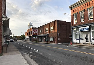
Colerain is a town in Bertie County, North Carolina, United States. The population was 204 at the 2010 census.

<span class="mw-page-title-main">Powellsville, North Carolina</span> Town in North Carolina, United States

Powellsville is a town in Bertie County, North Carolina, United States. The population was 276 at the 2010 census. The city is home to Travis Bond

<span class="mw-page-title-main">Roxobel, North Carolina</span> Town in North Carolina, United States

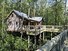
Roxobel is a town in northwestern Bertie County, North Carolina, United States. It dates to 1724 and was originally known as Cotten's Cross Roads. After several name changes, it has remained Roxobel since 1849. The population was 240 at the 2010 census.

Beulaville is a town located in Duplin County, North Carolina, United States. As of the 2020 census, the population was 1,116. At the previous census in 2010, the population was 1,296. The community lies within the Limestone Creek Township.

<span class="mw-page-title-main">Snow Hill, North Carolina</span> Town in North Carolina, United States

Snow Hill is a town in Greene County, North Carolina, United States. The population was 1,595 at the 2010 census. It is the county seat of Greene County and is part of the Greenville Metropolitan Area. Snow Hill hosts numerous tennis tournaments during the year. Snow Hill is home to the Green Ridge Racquet Club. Many junior players and adults travel to Snow Hill in order to play in the USTA Sanctioned tournaments.

<span class="mw-page-title-main">Ahoskie, North Carolina</span> Town in North Carolina, United States

Ahoskie is a town in Hertford County, North Carolina, United States. The population was 5,039 at the 2010 census. Ahoskie is located in North Carolina's Inner Banks region. Its nickname is "The Only One" because no other town in the world is known by the same name. The etymology of the word Ahoskie, which was originally spelled "Ahotsky", was from the Wyanoke Indians, who entered the Hertford County area at the beginning of European settlement.

<span class="mw-page-title-main">Spring Hope, North Carolina</span> Town in North Carolina, United States

Spring Hope is a town in Nash County, North Carolina, United States. It is part of the Rocky Mount, North Carolina Metropolitan Statistical Area. The population was 1,320 at the 2010 census.

<span class="mw-page-title-main">Jacksonville, North Carolina</span> City in North Carolina, United States

Jacksonville is a city in Onslow County, North Carolina, United States. As of the 2020 census, the population was 72,723, which makes Jacksonville the 14th-most populous city in North Carolina. Jacksonville is the county seat and most populous community of Onslow County, which is coterminous with the Jacksonville, NC Metropolitan Statistical Area. Demographically, Jacksonville is the youngest city in the United States, with an average age of 22.8 years old, which can be attributed to the large military presence. The low age may also be in part due to the population drastically increasing over the past 80 years, from 783 in the 1930 census to 72,723 in the 2020 census.

<span class="mw-page-title-main">Columbus, North Carolina</span> Town in North Carolina, United States

Columbus is a town and the county seat of Polk County, North Carolina, United States. The population was 999 at the 2010 census.

<span class="mw-page-title-main">Stoneville, North Carolina</span> Town in North Carolina, United States

Stoneville is a town in Rockingham County, North Carolina, United States. Stoneville is part of the Greensboro–High Point metropolitan area of the Piedmont Triad. On March 20, 1998, an F-3 tornado touched down in neighboring Madison and Mayodan after the system had crossed into Rockingham County from Stokes County. Then, it strengthened into an F-3 as it crossed Route 220 as it followed the train tracks to downtown Stoneville.

<span class="mw-page-title-main">Beale Township, Pennsylvania</span> Township in Pennsylvania, United States

Beale Township is a township in Juniata County, Pennsylvania, United States. The population was 769 at the 2020 census, a decline from the figure of 830 tabulated in 2010.

<span class="mw-page-title-main">Allendale, South Carolina</span> Town in South Carolina, United States

Allendale is a town in and the county seat of Allendale County, South Carolina, United States. The population was 3,482 at the 2010 census, a decline from 4,052 in 2000.

<span class="mw-page-title-main">Pulaski, Virginia</span> Town in Virginia, United States

Pulaski is a town in Pulaski County, Virginia, United States. The population was 9,086 at the 2010 census. It is the county seat of Pulaski County.

<span class="mw-page-title-main">North Augusta, South Carolina</span> City in South Carolina, United States

North Augusta is a city in Aiken and Edgefield counties in the U.S. state of South Carolina, on the north bank of the Savannah River. It lies directly across the river, and state border, from Augusta, Georgia. The population was 24,379 at the 2020 census, making it the 21st most populous city in South Carolina. The city is included in the Central Savannah River Area (CSRA) and is part of the Augusta, Georgia, metropolitan area.

<span class="mw-page-title-main">Windsor, New York</span> Town in New York, United States

Windsor is a town in Broome County, New York, United States. The population was 5,804 at the 2020 census.

References

  1. "ArcGIS REST Services Directory". United States Census Bureau. Retrieved September 20, 2022.
  2. 1 2 U.S. Geological Survey Geographic Names Information System: Windsor, North Carolina
  3. 1 2 "U.S. Census website". United States Census Bureau . Retrieved January 31, 2008.
  4. 1 2 "Geographic Identifiers: 2010 Demographic Profile Data (G001): Windsor town, North Carolina". U.S. Census Bureau, American Factfinder. Archived from the original on February 12, 2020. Retrieved February 6, 2014.
  5. "Find a County". National Association of Counties. Retrieved June 7, 2011.
  6. "National Register Information System". National Register of Historic Places . National Park Service. July 9, 2010.
  7. Herzmann, Daryl. "IEM :: PNS from NWS AKQ". mesonet.agron.iastate.edu. Retrieved August 31, 2020.
  8. US Department of Commerce, NOAA. "Summary of Tropical Storm Isaias". www.weather.gov. Retrieved August 31, 2020.
  9. "About Us". Jeremy Maxik. Retrieved September 17, 2015.
  10. "Our Parks". Jeremy Maxik. Retrieved September 24, 2015.
  11. "Census of Population and Housing". Census.gov. Retrieved June 4, 2015.
  12. "Explore Census Data". data.census.gov. Retrieved December 24, 2021.