Statesville, North Carolina

Last updated

Statesville, North Carolina
Statesville, North Carolina - City Hall.JPG
Statesville City Hall, built c.1890–92
Statesville, NC City Seal.jpg
Statesville, NC City Logo.jpg
NCMap-doton-Statesville.PNG
Location of Statesville, North Carolina
Coordinates: 35°47′03″N80°52′18″W / 35.78417°N 80.87167°W / 35.78417; -80.87167
CountryUnited States
State North Carolina
County Iredell
Government
  MayorCosti Kutteh
Area
[1]
  Total25.44 sq mi (65.88 km2)
  Land25.32 sq mi (65.59 km2)
  Water0.11 sq mi (0.29 km2)
Elevation
[2]
850 ft (260 m)
Population
 (2020)
  Total28,419
  Density1,122.17/sq mi (433.28/km2)
Time zone UTC−5 (Eastern (EST))
  Summer (DST) UTC−4 (EDT)
ZIP Codes
28625, 28677, 28687
Area code(s) 704, 980
FIPS code 37-64740 [3]
GNIS feature ID2405526 [2]
Website www.statesvillenc.net

Statesville is a city in and the county seat of Iredell County, North Carolina, United States, and it is part of the Charlotte metropolitan area. [4] Statesville was established in 1789 by an act of the North Carolina Legislature. [5] The population was 28,419 at the time of the 2020 census.

Contents

History

In 1753, Scots-Irish Presbyterians and German Lutherans, who had originally settled in Pennsylvania, began arriving in what would become Statesville in 1789 [5] to plant crops in the fertile soil where game and water were also plentiful. The settlement, known as Fourth Creek Congregation, was named for the freshwater stream running to the north of the present-day city center, the fourth creek west of the neighboring settlement of Salisbury. The center of the settlement was a log cabin where the Presbyterians worshiped and where the First Presbyterian Church is located today.

U.S. Court House and Post Office in 1900 Statesville Old U.S. Court House and Post Office.jpg
U.S. Court House and Post Office in 1900
Madison building in Statesville Commercial Historic District (1982) Statesville Commercial Historic District, Madison Building, Between 125 & 145 East Broad Street, Statesville (Iredell County, North Carolina).jpg
Madison building in Statesville Commercial Historic District (1982)

In 1755, colonial governor Arthur Dobbs authorized the construction of the colony's frontier fort, which was located approximately 3 miles (5 km) due north of the Fourth Creek settlement. Built and garrisoned by North Carolina provincial soldiers, Fort Dobbs defended British North America's western frontier in the colony of North Carolina during the French and Indian War and Anglo-Cherokee War. Fort Dobbs combined the functions of a military barracks, fortification, refuge for settlers, provisioning depot and center for negotiations with Native Americans. [6]

The state legislature divided Rowan County in 1788, and the new county was named "Iredell" for James Iredell, associate justice of the first Supreme Court during the presidency of George Washington. [7] [8]

One year later, the legislature selected a spot for the county seat. The Fourth Creek Congregation was chosen, and the settlement became known as "Statesville". The 1800 US Census lists the town as "States Ville", which was later combined as "Statesville". In 1800, there were 95 inhabitants in "States Ville", including 68 free white persons and 27 slaves. [9]

As early as 1833, Statesville's leaders began laying track for railroads to connect the Piedmont area of North Carolina with the rest of the country. [5]

By 1858, Statesville was growing rapidly and soon afterward began leading the state in the production of tobacco and tobacco products, the manufacture and blending of whiskey, and became a large distribution center for roots and herbs. [5]

On August 27, 1891, a passenger train derailed on the Bostian Bridge, [10] a 300-foot-long (91 m) bridge, and seven cars fell down. About 30 people died in the accident. [11]

Geography

Statesville is in central Iredell County, in the western part of the Piedmont region of North Carolina.

According to the U.S. Census Bureau, Statesville has a total area of 24.4 square miles (63.1 km2), of which 24.2 square miles (62.8 km2) are land and 0.1 square miles (0.3 km2), or 0.48%, are water. [12] The north side of Statesville is drained by Fourth Creek, while the south side is drained by Third Creek. Both creeks flow east, joining just before reaching the South Yadkin River near Cooleemee.

Climate

Statesville has a humid subtropical climate (Cfa) like most of the state of North Carolina, although its higher elevation leads to cooler temperatures than much of the Piedmont. Summers are generally hot and humid, with mild nights, while winters are usually cool with chilly nights and sporadic snowfall. Severe thunderstorms can be an issue during summer, with wind speeds of 60 mph and even gusts of 95 mph being recorded during these storms. [13]

Climate data for Statesville
MonthJanFebMarAprMayJunJulAugSepOctNovDecYear
Record high °F (°C)81
(27)
83
(28)
93
(34)
95
(35)
99
(37)
105
(41)
105
(41)
106
(41)
104
(40)
96
(36)
85
(29)
80
(27)
106
(41)
Mean daily maximum °F (°C)48.8
(9.3)
52.9
(11.6)
60.5
(15.8)
70.1
(21.2)
77.4
(25.2)
84.1
(28.9)
87.3
(30.7)
85.5
(29.7)
79.7
(26.5)
70.8
(21.6)
60
(16)
51.6
(10.9)
69.1
(20.6)
Daily mean °F (°C)37.6
(3.1)
40.6
(4.8)
47.6
(8.7)
56.9
(13.8)
65.5
(18.6)
73.3
(22.9)
77.0
(25.0)
75.4
(24.1)
69.2
(20.7)
56.3
(13.5)
47.1
(8.4)
37.9
(3.3)
57.0
(13.9)
Mean daily minimum °F (°C)26.4
(−3.1)
28.4
(−2.0)
34.7
(1.5)
43.7
(6.5)
53.6
(12.0)
62.5
(16.9)
66.8
(19.3)
65.2
(18.4)
58.8
(14.9)
45.8
(7.7)
34.3
(1.3)
28.9
(−1.7)
45.8
(7.6)
Record low °F (°C)−8
(−22)
−7
(−22)
5
(−15)
17
(−8)
28
(−2)
36
(2)
44
(7)
44
(7)
30
(−1)
16
(−9)
6
(−14)
−3
(−19)
−8
(−22)
Average precipitation inches (mm)3.71
(94)
3.18
(81)
3.99
(101)
4.05
(103)
3.70
(94)
4.27
(108)
4.42
(112)
4.91
(125)
3.87
(98)
3.23
(82)
3.38
(86)
3.94
(100)
46.65
(1,184)
Average snowfall inches (cm)2.4
(6.1)
0.8
(2.0)
0.4
(1.0)
0
(0)
0
(0)
0
(0)
0
(0)
0
(0)
0
(0)
0
(0)
0
(0)
1.3
(3.3)
4.9
(12.4)
Source: NOAA [14]

Demographics

Historical population
CensusPop.Note
1800 95
1850 215
1860 32048.8%
1870 683113.4%
1880 1,06255.5%
1890 2,318118.3%
1900 3,14135.5%
1910 4,59946.4%
1920 7,89571.7%
1930 10,49032.9%
1940 11,4409.1%
1950 16,90147.7%
1960 19,84417.4%
1970 20,0070.8%
1980 18,622−6.9%
1990 17,567−5.7%
2000 23,32032.7%
2010 24,5325.2%
2020 28,41915.8%
U.S. Decennial Census [15]

2020 census

Statesville racial composition [16]
RaceNumberPercentage
White (non-Hispanic)14,15449.8%
Black or African American (non-Hispanic)9,05431.86%
Native American 560.2%
Asian 5451.92%
Other/Mixed 1,3014.58%
Hispanic or Latino 3,30911.64%

As of the 2020 United States census, there were 28,419 people, 10,628 households, and 6,536 families residing in the city.

2010 census

As of the census [3] of 2010, there were 24,633 people, 9,338 households, and 5,957 families residing in the city. The population density was 1,195.8 inhabitants per square mile (461.7/km2). There were 10,041 housing units at an average density of 489.1 per square mile (188.8/km2). The racial composition of the city was: 59.94% White, 31.87% Black or African American, 7.11% Hispanic or Latino American, 2.71% Asian American, 0.18% Native American, 0.02% Native Hawaiian or Other Pacific Islander, 3.84% some other races, and 1.42% two or more races.

There were 9,338 households, out of which 28.1% had children under the age of 18 living with them, 41.7% were married couples living together, 17.9% had a female householder with no husband present, and 36.2% were non-families. 31.4% of all households were made up of individuals, and 12.7% had someone living alone who was 65 years of age or older. The average household size was 2.39 and the average family size was 2.99. [3]

In the city, the population was spread out, with 24.4% under the age of 18, 8.7% from 18 to 24, 28.0% from 25 to 44, 21.4% from 45 to 64, and 17.4% who were 65 years of age or older. The median age was 37 years. For every 100 females, there were 86.5 males. For every 100 females age 18 and over, there were 82.0 males. [3]

The median income for a household in the city was $31,925, and the median income for a family was $41,694. Males had a median income of $31,255 versus $22,490 for females. The per capita income for the city was $19,328. About 12.7% of families and 16.1% of the population were below the poverty line, including 23.7% of those under age 18 and 13.8% of those age 65 or over. [3]

Arts and culture

Historic sites

Museums

The Governor Zebulon Vance House and Museum is operated by the United Daughters of the Confederacy; Vance lived in the house at the end of the U.S. Civil War. Other museums include Iredell Museums, [20] Heritage Museum, and The Children's Museum.

Sports

Statesville was home to a minor league baseball teams of various names, mainly the Statesville Owls, from 1939 until 1969. They played in several leagues over the years including the Tar Heel League (1939–1940), North Carolina State League (1942, 1947–1952), Western Carolina League (1960–1962), and Western Carolinas League (1963–1969). They were league champions in their respective league in 1940, 1948, and 1962. The field was located at Statesville Senior High School and thus named Senior High Stadium. [21]

Education

The city is part of the Iredell–Statesville School District. Schools within the city limits include East Iredell Elementary, N.B. Mills Elementary, Oakwood Middle School, Pressly Elementary, and Statesville High School. Schools serving Statesville residents but located outside the city limits include Cloverleaf Elementary School, East Iredell Middle School, and Third Creek Elementary School. [22]

Wayside Elementary School was an elementary school located off Salisbury Road in eastern Statesville. The current school building opened in 1941 and closed in 2002 when Wayside School and Alan D. Rutherford School merged to form Third Creek Elementary. The former Wayside building is currently home to the UAW 3520 headquarters, while the former Alan D. Rutherford site is home to the Iredell-Statesville Schools Administrative Annex, now known as the Alan D. Rutherford Education Building.

Statesville Christian School is a non-denominational K4–12 private school serving the greater Statesville area. [23]

Mitchell Community College, founded as a Presbyterian women's college in 1852, is now a public community college. In the 2008–2009 academic year, it became the first community college in the United States to be accepted into NASA's University Student Launch Initiative competition. [24]

Media

Print

Radio

In addition, the signals of many stations from the Charlotte area and Piedmont Triad region reach Statesville.

Infrastructure

Highways

Interstate 40 and Interstate 77 intersect in the northeastern part of the city, and US 21, US 64, and US 70 run through the center of Statesville.

Notable people

Related Research Articles

<span class="mw-page-title-main">Iredell County, North Carolina</span> County in North Carolina, United States

Iredell County is a county located in the U.S. state of North Carolina. As of the 2020 census, the population was 186,693. Its county seat is Statesville, and its largest community is Mooresville. The county was formed in 1788, subtracted from Rowan County. It is named for James Iredell, one of the first justices of the Supreme Court. Iredell County is included in the Charlotte-Concord-Gastonia, NC-SC Metropolitan Statistical Area, as defined by the Office of Management and Budget with data from the U.S. Census Bureau.

<span class="mw-page-title-main">Alexander County, North Carolina</span> County in North Carolina, United States

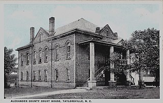
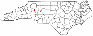
Alexander County is a county established in the U.S. state of North Carolina in 1847. As of the 2020 census, the population was 36,444. Its county seat is Taylorsville. Alexander County is part of the Hickory-Lenoir-Morganton, NC Metropolitan Statistical Area.

<span class="mw-page-title-main">Harmony, North Carolina</span> Town in North Carolina, United States

Harmony is a town in Iredell County, North Carolina, United States. The town was incorporated in 1927 and is located in northeastern Iredell County and lies in the eastern portion of the North Carolina High Country. It is primarily located in Turnersburg Township, with its northernmost portion in Eagle Mills Township. The population was 531 at the 2010 census.

<span class="mw-page-title-main">Huntersville, North Carolina</span> Town in North Carolina, United States

Huntersville is a large suburban town in northern Mecklenburg County, North Carolina, United States. At the 2020 census, its population was 61,376, making Huntersville the 15th-most populous municipality in North Carolina. It is located in the Charlotte metropolitan area and 14 mi (23 km) north of Charlotte.

<span class="mw-page-title-main">Stony Point, North Carolina</span> Census-designated place in North Carolina, United States

Stony Point is a census-designated place (CDP) in Alexander and Iredell counties in the U.S. state of North Carolina. The population was 1,317 at the 2010 census. It is part of the Hickory–Lenoir–Morganton Metropolitan Statistical Area.

<span class="mw-page-title-main">Union Grove Township, Iredell County, North Carolina</span> Township in North Carolina, United States

Union Grove Township is a rural, non-functioning county subdivision established in 1868 in Iredell County, North Carolina, United States. Two towns have existed in Union Grove township: 1) the unincorporated community Union Grove, established in 1857 and 2) the former town of Williamsburg established in 1812. The Union Grove Post Office was established in 1857. In 2019, within the unincorporated town of Union Grove is the Union Grove Milling Company, Union Grove School, Union Grove Volunteer Fire House, and two Methodist churches. In the later half of the 20th century, Union Grove was famous for the Fiddler's Convention which was held in Union Grove from the 1920s to 1970s. The Fiddler's Convention was originally established to benefit the Union Grove school.

Houstonville is an unincorporated community in the Eagle Mills Township of Iredell County, North Carolina, United States. Houstonville is located on U.S. Route 21, 3.3 miles (5.3 km) north of Harmony. Houstonville was founded in 1789 by Christopher Houston and is the second oldest town in Iredell County after the county seat, Statesville.

<span class="mw-page-title-main">Turnersburg Township, Iredell County, North Carolina</span> Township in North Carolina, United States

Turnersburg Township is a nonfunctioning administrative division in northeastern Iredell County, North Carolina, United States. Turnersburg township was established in 1868. The only major town in Turnersburg township is Harmony, which is also partially within Eagle Mills township.

<span class="mw-page-title-main">Barringer Township, Iredell County, North Carolina</span> Township in North Carolina, United States

Barringer Township is a non-functioning township in Iredell County, North Carolina, United States. By the requirements of the North Carolina Constitution of 1868, the counties were divided into townships, including sixteen in Iredell County.

<span class="mw-page-title-main">Bethany Township, Iredell County, North Carolina</span> Township in North Carolina, United States

Bethany Township is a non-functioning administrative division of Iredell County, North Carolina, United States. By the requirements of the North Carolina Constitution of 1868, the counties were divided into townships, which included Bethany township as one of sixteen townships in Iredell County.

<span class="mw-page-title-main">Chambersburg Township, North Carolina</span> Township in North Carolina, United States

Chambersburg Township is a township in Iredell County, North Carolina, United States. The 2010 United States Census reported a total population of 11,344.

<span class="mw-page-title-main">Concord Township, Iredell County, North Carolina</span> Township in North Carolina, United States

Concord Township is a non-functioning administrative division of Iredell County, North Carolina, United States. By the requirements of the North Carolina Constitution of 1868, the counties were divided into townships, which included Concord township as one of sixteen townships in Iredell County.

<span class="mw-page-title-main">Sharpesburg Township, Iredell County, North Carolina</span> Township in North Carolina, United States

Sharpesburg Township is a non-functioning administrative division of Iredell County, North Carolina, United States. By the requirements of the North Carolina Constitution of 1868, the counties were divided into townships, which included Sharpesburg township as one of sixteen townships in Iredell county.

<span class="mw-page-title-main">Statesville Township, Iredell County, North Carolina</span> Township in North Carolina, United States

Statesville Township is a non-functioning administrative division of Iredell County, North Carolina, United States. By the requirements of the North Carolina Constitution of 1868, the counties were divided into townships, which included Statesville township as one of sixteen townships in Iredell county. The town of Statesville, North Carolina is contained mostly within Statesville township.

<span class="mw-page-title-main">Coddle Creek Township, Iredell County, North Carolina</span> Township in North Carolina, United States

Coddle Creek Township is a non-functioning civil township in Iredell County, North Carolina, United States. By the requirements of the North Carolina Constitution of 1868, the counties were divided into townships, including sixteen in Iredell County. Part of the town of Mooresville is within Coddle Creek Township.

<span class="mw-page-title-main">Cool Springs Township, Iredell County, North Carolina</span> Township in North Carolina, United States

Cool Springs Township is a non-functioning administrative division of Iredell County, North Carolina, United States. By the requirements of the North Carolina Constitution of 1868, the counties were divided into townships, which included Cool Springs township as one of sixteen townships in Iredell County.

<span class="mw-page-title-main">Eagle Mills Township, Iredell County, North Carolina</span> Township in North Carolina, United States

Eagle Mills Township is a rural, non-functioning subdivision of Iredell County, North Carolina, United States. By the requirements of the North Carolina Constitution of 1868, the counties were divided into townships, which included Eagle Mills. Eagle Mills Township was named for the town of Eagle Mills, which was established by Andrew Baggerly on Hunting Creek in 1848.

<span class="mw-page-title-main">Fourth Creek Congregation</span> Presbyterian group formed in 1750 in the Province of North Carolina, United States

The community of the Fourth Creek Congregation was a group of Scots-Irish Presbyterians who first arrived in the Province of North Carolina in the mid to late 1730s and established a congregation by 1750 under pastor John Thompson in Anson County which became Rowan County in 1753 and finally Iredell County in 1788. The site of the Fourth Creek Congregation was chosen as the location of the county seat of Iredell County in 1789 and was named Statesville in 1789. The Fourth Creek Presbyterian Church officially became the First Presbyterian Church of Statesville in 1875.

Homer Maxwell Keever was a local historian, journalist, Methodist deacon, high school teacher, and author of hundreds of local histories published in Statesville, North Carolina about the history and folklore of Iredell County, North Carolina, including the book, Iredell, Piedmont County, published for the United States Bicentennial.

John Nisbet (1738–1817) was a merchant, patriot during the American Revolution, delegate from the newly formed Iredell County, North Carolina to the Fayetteville Convention in 1789 that ratified the Constitution of the United States for North Carolina, and first state senator from Iredell County.

References

  1. "ArcGIS REST Services Directory". United States Census Bureau. Retrieved September 20, 2022.
  2. 1 2 U.S. Geological Survey Geographic Names Information System: Statesville, North Carolina
  3. 1 2 3 4 5 "U.S. Census website". United States Census Bureau . Retrieved January 31, 2008.
  4. "Find a County". National Association of Counties. Archived from the original on May 31, 2011. Retrieved June 7, 2011.
  5. 1 2 3 4 Keever, Homer M.; Iredell Piedmont County, with illustrations by Louise Gilbert and maps by Mild red Jenkins Miller, published for the Iredell County Bicentennial Commission by Brady Printing Company from type set by the Statesville Record and Landmark, copyright, November 1976
  6. "Grand Opening of Fort Dobbs". fortdobbs.org. Archived from the original on September 24, 2019. Retrieved September 24, 2019.
  7. John L. Cheney, Jr., ed. (1975). North Carolina Government, 1585-1974, A Narrative and Statistical History.
  8. Lewis, J.D. "North Carolina General Assemblies, 1800s". Carolana.com. Archived from the original on August 9, 2019. Retrieved November 28, 2019.
  9. "United States Census, 1800," database with images, FamilySearch (https://familysearch.org/ark:/61903/1:1:XHR8-5KZ  : accessed 19 December 2018), States Ville, Iredell, North Carolina, United States; citing p. 675, NARA microfilm publication M32, (Washington D.C.: National Archives and Records Administration, n.d.), roll 29; FHL microfilm 337,905.
  10. Moose, Bill. "Bostian Bridge Train Wreck | NCpedia". www.ncpedia.org. Encyclopedia of North Carolina, University of North Carolina Press. Retrieved October 25, 2023.
  11. Gast, Phil (August 28, 2010). "'Ghost train' hunter killed by train in North Carolina". CNN. Archived from the original on August 29, 2010. Retrieved August 29, 2010.
  12. "Geographic Identifiers: 2010 Census Summary File 1 (G001): Statesville city, North Carolina". American Factfinder. U.S. Census Bureau. Archived from the original on February 13, 2020. Retrieved April 9, 2018.
  13. "Trees down, storm damage in Statesville after severe weather". wcnc.com. Retrieved August 17, 2020.
  14. "Statesville Climate Info". NOAA. Retrieved May 15, 2021.
  15. "Census of Population and Housing". Census.gov. Retrieved June 4, 2015.
  16. "Explore Census Data". data.census.gov. Retrieved December 21, 2021.
  17. 1 2 3 4 5 6 7 8 9 10 11 12 13 14 "National Register Information System". National Register of Historic Places . National Park Service. July 9, 2010.
  18. "STATESVILLE SYNAGOGUE LEARNS IT'S ONE OF THE OLDEST IN THE NATION". Charlotte Observer. January 19, 1997.
  19. "North Carolina Highway marker 46, Fourth Creek Congregation". Archived from the original on February 7, 2019. Retrieved February 6, 2019.
  20. "Iredell County Museums". iredellmuseums.org. Archived from the original on July 13, 2019. Retrieved December 27, 2019.
  21. "Scraps from Statesville, Part 2". futureangles.mlbogs.com.
  22. "Schools". Iredell–Statesville School District. Archived from the original on December 29, 2019. Retrieved April 9, 2018.
  23. "Statesville Christian School" (PDF). statesvillechristian.org. Archived (PDF) from the original on February 12, 2019. Retrieved December 27, 2019.
  24. Powell, William S. (1970). Higher Education in North Carolina. Raleigh: State Department of Archives and History. Archived from the original on December 29, 2019. Retrieved December 29, 2019.
  25. "Statesville Record & Landmark home page". statesville.com. Archived from the original on December 17, 2019. Retrieved December 27, 2019.
  26. "RealCountry929". realcountry929.com. Archived from the original on November 7, 2016. Retrieved December 27, 2019.
  27. "WSICfm". WSICfm.com. Archived from the original on June 30, 2019. Retrieved December 27, 2019.
  28. "Breon Borders". Duke Athletics. Retrieved July 9, 2017.
  29. The Infestation: The "Fallen Angel" Chris Cole. Bleacher Report. Retrieved November 7, 2020.
  30. Barry Moore Stats. Baseball-Reference. Retrieved November 7, 2020.
  31. Graham, Nicholas (2012). "William S. Powell". ncpedia.org. Archived from the original on May 11, 2019. Retrieved August 23, 2013., updated 2015 by Government & Heritage Library staff
  32. William Sharpe - NC Highway Historical Marker Program. Retrieved November 7, 2020.
  33. "Monday Mansions: NASCAR driver Mike Skinner's home!". WXII-TV. August 4, 2013. Archived from the original on January 24, 2016. Retrieved October 20, 2015.