Alexander County, North Carolina

Last updated

Alexander County
Alexander Co. Courthouse 001 (22116495546).jpg
Alexander County Courthouse
Alexander County Flag.gif
Alexander county seal north carolina.gif
Motto(s): 
"A wonderful place to live, work and play."
Map of North Carolina highlighting Alexander County.svg
Location within the U.S. state of North Carolina
North Carolina in United States.svg
North Carolina's location within the U.S.
Coordinates: 35°55′N81°11′W / 35.92°N 81.18°W / 35.92; -81.18
CountryFlag of the United States.svg United States
StateFlag of North Carolina.svg  North Carolina
Founded1847
Named for William Julius Alexander [1]
Seat Taylorsville
Largest community Bethlehem
Area
  Total263.64 sq mi (682.8 km2)
  Land259.99 sq mi (673.4 km2)
  Water3.65 sq mi (9.5 km2)  1.39%
Population
 (2020)
  Total36,444
  Estimate 
(2023)
36,473
  Density140.17/sq mi (54.12/km2)
Time zone UTC−5 (Eastern)
  Summer (DST) UTC−4 (EDT)
Congressional district 10th
Website alexandercountync.gov

Alexander County is a county established in the U.S. state of North Carolina in 1847. As of the 2020 census, the population was 36,444. [2] Its county seat is Taylorsville. [3] [4] Alexander County is part of the Hickory-Lenoir-Morganton, NC Metropolitan Statistical Area.

Contents

History

Alexander County was formed in 1847 from portions of what were then Iredell County (formed in 1788 from Rowan County), Caldwell County (formed from Burke County in 1841), and Wilkes County (formed from Surry County and Washington District in 1771).

Alexander County was named for William Julius Alexander who was a Speaker of the North Carolina House of Commons. This Piedmont area was settled primarily by farmers, many of Scots-Irish descent, as well as German descent in the southern section of Alexander County. [5] [6]

Alexander County, North Carolina Map from 1854 Alexander County Map in 1854.jpg
Alexander County, North Carolina Map from 1854

The county was established by two acts of the North Carolina General Assembly, one ratified on January 15 and one ratified on January 18, 1847. These acts were not to take effect until it was determined that Caldwell County would have 5,000 people in it. On August 10–11, 1847, the first sale of land in the county seat (Taylorsville) took place. Taylorsville is the namesake of either John Louis Taylor, Carolina agriculturist and political philosopher, or General Zachary Taylor, the twelfth president of the United States. With the proceeds from the sale, the county built the first courthouse on the present site. [7]

When the American Civil War began in 1861, Alexander County was fourteen years old. The court house records in Taylorsville were destroyed by troops under Major General George Stoneman in a raid on Easter Sunday in 1865. [8]

The Alexander Railroad based in Taylorsville began in 1946, with one connection to Norfolk Southern in Statesville, North Carolina. The short line rail system operates between Taylorsville and Statesville.

Geography

Alexander County, North Carolina
Interactive map of Alexander County

According to the U.S. Census Bureau, the county has a total area of 263.64 square miles (682.8 km2), of which 259.99 square miles (673.4 km2) is land and 3.65 square miles (9.5 km2) (1.39%) is water. [9]

Alexander County is located within the Foothills region of western North Carolina. The county's main geographic feature is the Brushy Mountains, a deeply eroded spur of the Blue Ridge Mountains to the west. The "Brushies," as they are called locally, rise from 300 to 1,000 feet (300 m) above the surrounding countryside, and dominate the county's northern horizon. The highest point in Alexander County is Hickory Knob in the Brushies; it has an elevation of 2,560 feet (780 m) above sea level. Barrett Mountain, an isolated mountain ridge, is in the western part of the county. The remainder of Alexander County's terrain consists of gently rolling countryside. The county's largest river, the Catawba, forms its southern border.

Within Alexander County is the unincorporated town of Hiddenite, the location of a mine that yields emeralds, sapphires, and its namesake stone "hiddenite," a variety of spodumene.

The county is served by US Highway 64, a controlled-access roadway connecting Taylorsville with Lenoir and Statesville. NC Highways 90, 16, and 127 also serve the county. Interstate 40 and 77 are 30 minutes from the majority of county residents. The Charlotte Douglas International Airport is an hour's drive from most parts of the county. The area is also served by the Hickory Regional Airport (30 minutes) and the Statesville Airport (20 minutes). The Alexander Railroad Company is an active short-line rail system operating between Taylorsville and Statesville, and connecting with Norfolk Southern.

State and local protected area

Major water bodies

Adjacent counties

Major highways

Major infrastructure

Demographics

Historical population
CensusPop.Note
1850 5,220
1860 6,02215.4%
1870 6,86814.0%
1880 8,35521.7%
1890 9,43012.9%
1900 10,96016.2%
1910 11,5925.8%
1920 12,2125.3%
1930 12,9225.8%
1940 13,4544.1%
1950 14,5548.2%
1960 15,6257.4%
1970 19,46624.6%
1980 24,99928.4%
1990 27,54410.2%
2000 33,60322.0%
2010 37,19810.7%
2020 36,444−2.0%
2023 (est.)36,473 [2] 0.1%
U.S. Decennial Census [12]
1790–1960 [13] 1900–1990 [14]
1990–2000 [15] 2010 [16] 2020 [2]

2020 census

Alexander County racial composition [17]
RaceNumberPercentage
White (non-Hispanic)30,89384.77%
Black or African American (non-Hispanic)1,9195.27%
Native American 1110.3%
Asian 3901.07%
Pacific Islander 10.0%
Other/Mixed 1,2943.55%
Hispanic or Latino 1,8365.04%

As of the 2020 census, there were 36,444 people, 14,169 households, and 10,232 families residing in the county.

2000 census

At the 2000 census [18] there were 33,603 people, 13,137 households, and 9,747 families residing in the county. The population density was 129 people per square mile (50 people/km2). There were 14,098 housing units at an average density of 54 units per square mile (21 units/km2). The racial makeup of the county was 92.00% White, 4.63% Black or African American, 0.15% Native American, 1.04% Asian, 1.34% from other races, and 0.84% from two or more races. 2.50% of the population were Hispanic or Latino of any race.

There were 13,137 households, out of which 32.80% had children under the age of 18 living with them, 60.50% were married couples living together, 9.40% had a female householder with no husband present, and 25.80% were non-families. 21.90% of all households were made up of individuals, and 8.40% had someone living alone who was 65 years of age or older. The average household size was 2.54 and the average family size was 2.95.

In the county, the population was spread out, with 24.50% under the age of 18, 7.90% from 18 to 24, 31.10% from 25 to 44, 24.60% from 45 to 64, and 11.90% who were 65 years of age or older. The median age was 37 years. For every 100 females there were 99.40 males. For every 100 females age 18 and over, there were 96.70 males.

The median income for a household in the county was $38,684, and the median income for a family was $45,691. Males had a median income of $29,857 versus $21,868 for females. The per capita income for the county was $18,507. About 5.90% of families and 8.50% of the population were below the poverty line, including 10.20% of those under age 18 and 14.60% of those age 65 or over.

Government and politics

Alexander is currently a powerfully Republican county in Presidential elections. The only Democrat to carry the county in the past nineteen Presidential contests has been Jimmy Carter in 1976, although Barry Goldwater won the county by a mere thirty-eight votes in 1964. In contrast, Hillary Clinton in 2016 obtained barely twenty percent of the county's vote. The county did vote mainly Democratic during the Third Party System, but Populist sentiments in the 1890s have meant the county has supported the party only five times since 1896.

United States presidential election results for Alexander County, North Carolina [19]
Year Republican Democratic Third party
No.%No.%No.%
2020 15,88878.51%4,14520.48%2031.00%
2016 13,89376.04%3,76720.62%6113.34%
2012 12,25371.25%4,61126.81%3321.93%
2008 11,79068.33%5,16729.95%2971.72%
2004 10,92870.05%4,61829.60%540.35%
2000 9,24268.50%4,16630.88%840.62%
1996 6,74857.53%3,95533.72%1,0278.76%
1992 6,76449.64%4,84935.59%2,01314.77%
1988 7,96865.56%4,14834.13%380.31%
1984 8,50270.22%3,58129.58%240.20%
1980 6,37657.39%4,54640.92%1871.68%
1976 4,66146.73%5,28753.00%270.27%
1972 5,86568.95%2,46829.01%1732.03%
1968 4,37952.03%1,83421.79%2,20326.18%
1964 3,76050.25%3,72249.75%00.00%
1960 4,17551.35%3,95648.65%00.00%
1956 3,76758.16%2,71041.84%00.00%
1952 3,59757.44%2,66542.56%00.00%
1948 2,31447.98%2,05742.65%4529.37%
1944 2,97156.56%2,28243.44%00.00%
1940 2,21744.73%2,73955.27%00.00%
1936 2,45142.90%3,26257.10%00.00%
1932 1,95239.57%2,95359.86%280.57%
1928 2,60560.20%1,72239.80%00.00%
1924 2,43751.33%2,29148.25%200.42%
1920 2,64356.38%2,04543.62%00.00%
1916 1,18755.44%95444.56%00.00%
1912 52327.94%85245.51%49726.55%

Alexander County is a member of the regional Western Piedmont Council of Governments.

Communities

Map of Alexander County with municipal and township labels Map of Alexander County North Carolina With Municipal and Township Labels.PNG
Map of Alexander County with municipal and township labels

Town

Townships

By the requirements of the North Carolina Constitution of 1868, counties were divided into non-functioning county subdivisions called townships. There are eight townships in Alexander County: [20] [21]

Census-designated places

Unincorporated communities

Unincorporated communities in Alexander County include: [21]

Population ranking

The population ranking of the following table is based on the 2020 census of Alexander County. [23]

= county seat

RankNameTypePopulation
(2020 census)
1 Bethlehem CDP4,491
2 Taylorsville Town2,320
3 Stony Point CDP1,146
4 Hiddenite CDP507

Historic post offices and other sites

Historical post offices that were part of Alexander County include: [21]

Other historic sites

Lucas Mansion in Hiddenite Lucas Mansion - full frontal.jpg
Lucas Mansion in Hiddenite

See also

Related Research Articles

<span class="mw-page-title-main">Rowan County, North Carolina</span> County in North Carolina, United States

Rowan County is a county in the U.S. state of North Carolina that was formed in 1753, as part of the British Province of North Carolina. It was originally a vast territory with unlimited western boundaries, but its size was reduced to 524 square miles (1,360 km2) after several counties were formed from Rowan County in the 18th and 19th centuries. As of the 2020 census, its population was 146,875. Its county seat, Salisbury, is the oldest continuously populated European-American town in the western half of North Carolina. Rowan County is located northeast of Charlotte, and is considered part of the Charlotte-Concord-Gastonia, NC-SC Metropolitan Statistical Area.

<span class="mw-page-title-main">Iredell County, North Carolina</span> County in North Carolina, United States

Iredell County is a county located in the U.S. state of North Carolina. As of the 2020 census, the population was 186,693. Its county seat is Statesville, and its largest community is Mooresville. The county was formed in 1788, subtracted from Rowan County. It is named for James Iredell, one of the first justices of the Supreme Court. Iredell County is included in the Charlotte-Concord-Gastonia, NC-SC Metropolitan Statistical Area, as defined by the Office of Management and Budget, with data from the U.S. Census Bureau.

<span class="mw-page-title-main">Catawba County, North Carolina</span> County in North Carolina, United States

Catawba County is a county in the U.S. state of North Carolina. As of the 2020 census, the population was 160,610. Its county seat is Newton, and its largest community is Hickory.

<span class="mw-page-title-main">Caldwell County, North Carolina</span> County in North Carolina, United States

Caldwell County is a county in the U.S. state of North Carolina. It is located in the foothills of the Blue Ridge Mountains. As of the 2020 census, the population was 80,652. Its county seat is Lenoir. Caldwell County is part of the Hickory-Lenoir-Morganton, NC Metropolitan Statistical Area.

<span class="mw-page-title-main">Taylorsville, North Carolina</span> Town in North Carolina, United States

Taylorsville is a town in Alexander County, North Carolina, United States. The population was 2,098 at the 2010 census. It is the county seat of Alexander County.

<span class="mw-page-title-main">Lenoir, North Carolina</span> City in North Carolina, United States

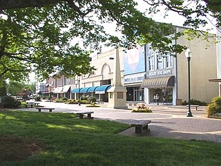
Lenoir is a city in and the county seat of Caldwell County, North Carolina, United States. The population was 18,263 at the 2020 census. Lenoir is located in the foothills of the Blue Ridge Mountains. To the northeast are the Brushy Mountains, a spur of the Blue Ridge Mountains. Hibriten Mountain, located just east of the city limits, marks the western end of the Brushy Mountains range.

<span class="mw-page-title-main">Statesville, North Carolina</span> City in North Carolina, United States

Statesville is a city in and the county seat of Iredell County, North Carolina, United States, and it is part of the Charlotte metropolitan area. Statesville was established in 1789 by an act of the North Carolina Legislature. The population was 28,419 at the time of the 2020 census.

<span class="mw-page-title-main">Stony Point, North Carolina</span> Census-designated place in North Carolina, United States

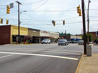
Stony Point is a census-designated place (CDP) in Alexander and Iredell counties in the U.S. state of North Carolina. The population was 1,317 at the 2010 census. It is part of the Hickory–Lenoir–Morganton Metropolitan Statistical Area.

Hiddenite is a census-designated place (CDP) in east-central Alexander County, North Carolina, United States. The population was 536 at the 2010 census. It is part of the Hickory–Lenoir–Morganton Metropolitan Statistical Area.

<span class="mw-page-title-main">Hickory–Lenoir–Morganton metropolitan area</span> Metropolitan Statistical Area in North Carolina, United States

The Hickory–Lenoir–Morganton, NC Metropolitan Statistical Area, as defined by the United States Census Bureau, is an area consisting of four counties, Catawba, Burke, Caldwell, Alexander. It is located in the Catawba Valley region of western North Carolina. Local residents often refer to the area as The Unifour, although this name is largely unknown outside of the region.

The Alexander Railroad Company is a Class III shortline railroad operating in North Carolina. The railroad has 18 miles of track that runs northwest from Statesville to Taylorsville, North Carolina.

<span class="mw-page-title-main">Charlotte metropolitan area</span> Metropolitan Statistical Area in the United States

The Charlotte metropolitan area, sometimes referred to as Metrolina, is a metropolitan area of the U.S. states of North and South Carolina, containing the city of Charlotte. The metropolitan area also includes the cities of Gastonia, Concord, Huntersville, and Rock Hill as well as the large suburban area in the counties surrounding Mecklenburg County, which is at the center of the metro area. Located in the Piedmont, it is the largest metropolitan area in the Carolinas, and the fourth largest in the Southeastern United States. The Charlotte metropolitan area is one of the fastest growing metropolitan areas in the United States.

Olin is an unincorporated community located in Olin Township, Iredell County, North Carolina, United States. The community is 12 miles (19 km) north of Statesville. The Olin post office was first established in 1852 and continues to operate with a ZIP code 28660.

<span class="mw-page-title-main">Barringer Township, Iredell County, North Carolina</span> Township in North Carolina, United States

Barringer Township is a non-functioning township in Iredell County, North Carolina, United States. By the requirements of the North Carolina Constitution of 1868, the counties were divided into townships, including sixteen in Iredell County.

<span class="mw-page-title-main">Chambersburg Township, North Carolina</span> Township in North Carolina, United States

Chambersburg Township is a township in Iredell County, North Carolina, United States. The 2010 United States Census reported a total population of 11,344.

<span class="mw-page-title-main">Concord Township, Iredell County, North Carolina</span> Township in North Carolina, United States

Concord Township is a non-functioning administrative division of Iredell County, North Carolina, United States. By the requirements of the North Carolina Constitution of 1868, the counties were divided into townships, which included Concord township as one of sixteen townships in Iredell County.

<span class="mw-page-title-main">Cool Springs Township, Iredell County, North Carolina</span> Township in North Carolina, United States

Cool Springs Township is a non-functioning administrative division of Iredell County, North Carolina, United States. By the requirements of the North Carolina Constitution of 1868, the counties were divided into townships, which included Cool Springs township as one of sixteen townships in Iredell County.

<span class="mw-page-title-main">Eagle Mills Township, Iredell County, North Carolina</span> Township in North Carolina, United States

Eagle Mills Township is a rural, non-functioning subdivision of Iredell County, North Carolina, United States. By the requirements of the North Carolina Constitution of 1868, the counties were divided into townships, which included Eagle Mills. Eagle Mills Township was named for the town of Eagle Mills, which was established by Andrew Baggerly on Hunting Creek in 1848.

<span class="mw-page-title-main">Fourth Creek Congregation</span> Presbyterian group formed in 1750 in the Province of North Carolina, United States

The community of the Fourth Creek Congregation was a group of Scots-Irish Presbyterians who first arrived in the Province of North Carolina in the mid to late 1730s and established a congregation by 1750 under pastor John Thompson in Anson County which became Rowan County in 1753 and finally Iredell County in 1788. The site of the Fourth Creek Congregation was chosen as the location of the county seat of Iredell County in 1789 and was named Statesville in 1789. The Fourth Creek Presbyterian Church officially became the First Presbyterian Church of Statesville in 1875.

<span class="mw-page-title-main">Williamsburgh, North Carolina</span> Town in North Carolina, United States

Williamsburgh was a town in north Iredell County, North Carolina from 1815 to 1971. It was the second town in Iredell County established by the North Carolina General Assembly, after Statesville, North Carolina. In the 1800s, the town contained a tavern, post office, church, and possibly a horse racing venue. Williamsburgh was located in the southeast section of Union Grove Township, which was created in 1868. The only portions of the town to survive after its charter was repealed in 1971 was the Macedonia Methodist Church.

References

  1. "Alexander County (1847)". www.northcarolinahistory.org. Retrieved June 13, 2022.
  2. 1 2 3 "QuickFacts: Alexander County, North Carolina". United States Census Bureau. Retrieved March 21, 2024.
  3. "Find a County". National Association of Counties. Archived from the original on May 31, 2011. Retrieved June 7, 2011.
  4. Vocci, Robert Blair (2006). "Alexander County, North Carolina". NCPedia. Archived from the original on January 1, 2021. Retrieved August 8, 2019.
  5. 1 2 Crouse, Andrew Leonhardt (1905). Historical Sketches of Alexander County, North Carolina, Friendship Lutheran Church, Hopewell Reformed Church, and Charity Baptist Church, and of the Bowman and Fry Families. Hickory, North Carolina. Archived from the original on January 1, 2021. Retrieved August 8, 2019.{{cite book}}: CS1 maint: location missing publisher (link)
  6. Martin, Jonathan. "Alexander County (1847)". North Carolina History Project. John Locke Foundation. Archived from the original on January 1, 2021. Retrieved December 8, 2012.
  7. White, William E. (1926). Taylorsville Times (ed.). A History of Alexander County, North Carolina (PDF). Archived (PDF) from the original on October 7, 2015. Retrieved June 3, 2019., Alternate: "A History of Alexander County, North Carolina". Barnes Oxford Foundation. Retrieved January 1, 2021.
  8. 1 2 Lewis, J.D. "Alexander County, North Carolina". The American Revolution in North Carolina. Archived from the original on January 1, 2021. Retrieved August 9, 2019.
  9. "2020 County Gazetteer Files – North Carolina". United States Census Bureau. August 23, 2022. Retrieved September 9, 2023.
  10. "Lookout Shoals Lake Perspective" (PDF). p-cd.duke-energy.com. January 2007. Retrieved June 15, 2023.
  11. 1 2 "South Yadkin River". www.deq.nc.gov. 2008. p. 2. Retrieved June 15, 2023.
  12. "U.S. Decennial Census". United States Census Bureau. Archived from the original on October 3, 2014. Retrieved January 11, 2015.
  13. "Historical Census Browser". University of Virginia Library. Archived from the original on August 11, 2012. Retrieved January 11, 2015.
  14. Forstall, Richard L., ed. (March 27, 1995). "Population of Counties by Decennial Census: 1900 to 1990". United States Census Bureau. Retrieved January 11, 2015.
  15. "Census 2000 PHC-T-4. Ranking Tables for Counties: 1990 and 2000" (PDF). United States Census Bureau. Archived (PDF) from the original on December 18, 2014. Retrieved January 11, 2015.
  16. "State & County QuickFacts". United States Census Bureau. Archived from the original on June 6, 2011. Retrieved October 17, 2013.
  17. "Explore Census Data". data.census.gov. Retrieved December 21, 2021.
  18. "U.S. Census website". United States Census Bureau. Archived from the original on December 27, 1996. Retrieved January 31, 2008.
  19. Leip, David. "Dave Leip's Atlas of U.S. Presidential Elections". uselectionatlas.org. Archived from the original on March 23, 2018. Retrieved March 14, 2018.
  20. "North Carolina Constitution of 1868" (PDF). Archived (PDF) from the original on May 8, 2019. Retrieved May 10, 2019.
  21. 1 2 3 Lewis, J.D. "Alexander County Post Offices". The American Revolution in North Carolina. Archived from the original on January 1, 2021. Retrieved August 8, 2019.
  22. 1 2 3 4 5 "Alexander County Comprehensive Plan" (PDF). Alexander County Board of Commissioners. April 21, 2008. Archived (PDF) from the original on January 1, 2021. Retrieved August 8, 2019.
  23. "City and Town Population Totals: 2020-2022". United States Census Bureau, Population Division. Archived from the original on July 11, 2022. Retrieved May 18, 2023.
  24. "Linney's Mill". Archived from the original on January 1, 2021. Retrieved August 8, 2019.

Further reading