Stokes County, North Carolina

Last updated

Stokes County
Old Stokes County Courthouse, Historic District of Danbury.jpg
Stokes County Flag.gif
Stokes County seal.png
Map of North Carolina highlighting Stokes County.svg
Location within the U.S. state of North Carolina
North Carolina in United States.svg
North Carolina's location within the U.S.
Coordinates: 36°23′N80°16′W / 36.39°N 80.27°W / 36.39; -80.27
CountryFlag of the United States.svg United States
StateFlag of North Carolina.svg  North Carolina
Founded1789
Named for John Stokes
Seat Danbury
Largest community King
Area
  Total456.14 sq mi (1,181.4 km2)
  Land449.35 sq mi (1,163.8 km2)
  Water6.79 sq mi (17.6 km2)  1.49%
Population
 (2020)
  Total44,520
  Estimate 
(2023)
45,532
  Density99.08/sq mi (38.26/km2)
Time zone UTC−5 (Eastern)
  Summer (DST) UTC−4 (EDT)
Congressional district 5th
Website www.co.stokes.nc.us

Stokes County is a county located in the U.S. state of North Carolina. As of the 2020 census, the population was 44,520. [1] Its county seat is Danbury. [2]

Contents

Stokes County is included in the Winston-Salem, NC, Metropolitan Statistical Area, which is also included in the Greensboro–Winston-Salem–High Point, NC, Combined Statistical Area.

History

Ruins of the Rock House, c. 1770, built by Capt. Jack Martin, Revolutionary War soldier and pioneer View of walls Rock House Stokes County North Carolina.JPG
Ruins of the Rock House, c. 1770, built by Capt. Jack Martin, Revolutionary War soldier and pioneer

The county was formed in 1789 from Surry County, and before 1770, it was part of Rowan County. It was named for John Stokes, an American Revolutionary War captain severely wounded when British Colonel Banastre Tarleton's cavalry practically destroyed Col. Abraham Buford's Virginia regiment in the Waxhaws region in 1780. After the war, Captain Stokes was appointed a judge of the United States district court for North Carolina. In 1849 the southern half of Stokes County became Forsyth County. [3]

Stokes was most heavily settled from 1750 to 1775. [4] The Great Wagon Road passed through the eastern portion of the county, and this influenced the pattern of European settlement so that most settlers came from the Virginia Piedmont, and some came from further away in Pennsylvania and other colonies. [5]

As North Carolina held their Secession Convention in May 1861, John Hill represented Stokes County. Unfortunately, while attending the convention in Raleigh, Hill had a stroke and died. He is buried in the Old Hill Burying Ground near Germanton. [6]

During the American Civil War, Moratock Iron Furnace located near Danbury served as a foundry for the Confederate Army. It was destroyed in April 1865 when Union cavalry under the command of General George Stoneman conducted extensive raiding through the region.

Hanging Rock State Park was formed primarily from blocks of land donated in 1936 and contained 6,921 acres (28.01 km2) in 2005. Many of the facilities in the park were built by the Civilian Conservation Corps between 1935 and 1942. The park is located atop the Sauratown Mountains, and contains a visitor's center, a manmade lake, and plenty of hiking trails, climbing trails, picnic areas, and primitive campgrounds.

Geography

Stokes County, North Carolina
Interactive map of Stokes County
The Sauratown Mountains cut through Stokes County which is otherwise gently rolling piedmont hills. The Blue Ridge Mountains in the background lie to the west of Stokes County. SauratownMountains.wmg.jpg
The Sauratown Mountains cut through Stokes County which is otherwise gently rolling piedmont hills. The Blue Ridge Mountains in the background lie to the west of Stokes County.

According to the U.S. Census Bureau, the county has a total area of 456.14 square miles (1,181.4 km2), of which 449.35 square miles (1,163.8 km2) is land and 6.79 square miles (17.6 km2) (1.49%) is water. [7]

The county lies within the Piedmont region of western North Carolina, and most of the terrain consists of gently rolling countryside. The county is part of Appalachia and the Sauratown Mountains run across the center of the county. The Sauras are named after the Saura Native American tribe which lived in the county before European settlement. A chain of jagged ridges, the Sauratown Mountains are an isolated remnant of the Blue Ridge Mountains far to the west. Although the Sauratown Mountains occupy only 5% of Stokes County, they dominate the scenery from almost any direction, abruptly rising from 800 to 1,700 feet (520 m) above the surrounding terrain. Moore's Knob, the highest point in the chain, rises to 2,579 feet (786 m). Most of the county is less than 1,000 feet (300 m) above sea level. The Dan River runs from the northwest corner to the southeastern section of Stokes County (covering over 56 miles of river recreation). Stokes County is home to Hanging Rock State Park and also has the vast majority of Belews Lake (located in the southeast corner).

Climate and weather

Danbury, NC
Climate chart (explanation)
J
F
M
A
M
J
J
A
S
O
N
D
 
 
3.7
 
 
48
24
 
 
3
 
 
52
26
 
 
4.3
 
 
60
32
 
 
3.6
 
 
70
40
 
 
4
 
 
77
49
 
 
4
 
 
84
59
 
 
5
 
 
88
64
 
 
4.3
 
 
86
62
 
 
4.6
 
 
80
54
 
 
3.6
 
 
71
42
 
 
3.3
 
 
62
33
 
 
3.6
 
 
51
26
Average max. and min. temperatures in °F
Precipitation totals in inches
Source: Applied Climate Information System [8]
Metric conversion
J
F
M
A
M
J
J
A
S
O
N
D
 
 
93
 
 
9
−4
 
 
77
 
 
11
−3
 
 
109
 
 
16
0
 
 
90
 
 
21
4
 
 
102
 
 
25
10
 
 
102
 
 
29
15
 
 
127
 
 
31
18
 
 
109
 
 
30
17
 
 
116
 
 
27
12
 
 
91
 
 
22
5
 
 
83
 
 
17
0
 
 
91
 
 
11
−3
Average max. and min. temperatures in °C
Precipitation totals in mm

The climate in Stokes County can be described as mixed-humid, with the Köppen Climate Classification subtype being Cfa. [9] In the county seat of Danbury an average of 39.73" of rain and 9.0" of snow falls per year. Temperatures normally range between a low of 24.2 °F (−4.3 °C) in January to a high of 89 °F 87.7 °F (30.9 °C) in July. Record extremes include: A maximum temperature reading of 103.0 °F (39.4 °C) on August 21, 1983. A minimum temperature reading of −10 °F (−23 °C) on January 21, 1985. A three-day accumulated snowfall record of 34.0" was set during the Blizzard of 1996. [8]

State and local protected areas

Major water bodies

Adjacent counties

Major highways

Demographics

Historical population
CensusPop.Note
1790 8,423
1800 11,02630.9%
1810 11,6455.6%
1820 14,03320.5%
1830 16,19615.4%
1840 16,2650.4%
1850 9,206−43.4%
1860 10,40213.0%
1870 11,2087.7%
1880 15,35337.0%
1890 17,19912.0%
1900 19,86615.5%
1910 20,1511.4%
1920 20,5752.1%
1930 22,2908.3%
1940 22,6561.6%
1950 21,520−5.0%
1960 22,3143.7%
1970 23,7826.6%
1980 33,08639.1%
1990 37,22312.5%
2000 44,71220.1%
2010 47,4016.0%
2020 44,520−6.1%
2023 (est.)45,532 [1] 2.3%
U.S. Decennial Census [11]
1790–1960 [12] 1900–1990 [13]
1990–2000 [14] 2010 [15] 2020 [1]

2020 census

Stokes County racial composition [16]
RaceNumberPercentage
White (non-Hispanic)39,60988.97%
Black or African American (non-Hispanic)1,6193.64%
Native American 1400.31%
Asian 1580.35%
Pacific Islander 110.02%
Other/Mixed 1,5273.43%
Hispanic or Latino 1,4563.27%

As of the 2020 census, there were 44,520 people, 19,578 households, and 13,348 families residing in the county.

2000 census

At the 2000 census, [17] there were 44,712 people, 17,579 households, and 13,043 families residing in the county. The population density was 99 people per square mile (38 people/km2). There were 19,262 housing units at an average density of 43 units per square mile (17 units/km2). The racial makeup of the county was 93.43% White, 4.66% Black or African American, 0.24% Native American, 0.19% Asian, 0.05% Pacific Islander, 0.88% from other races, and 0.54% from two or more races. 1.87% of the population were Hispanic or Latino of any race.

There were 17,579 households, out of which 33.80% had children under the age of 18 living with them, 60.60% were married couples living together, 9.70% had a female householder with no husband present, and 25.80% were non-families. 22.80% of all households were made up of individuals, and 8.90% had someone living alone who was 65 years of age or older. The average household size was 2.51 and the average family size was 2.94.

In the county, the population was spread out, with 24.50% under the age of 18, 7.30% from 18 to 24, 31.40% from 25 to 44, 25.00% from 45 to 64, and 11.80% who were 65 years of age or older. The median age was 37 years. For every 100 females there were 96.10 males. For every 100 females age 18 and over, there were 92.60 males.

The median income for a household in the county was $38,808, and the median income for a family was $44,615. Males had a median income of $30,824 versus $24,319 for females. The per capita income for the county was $18,130. About 6.90% of families and 9.10% of the population were below the poverty line, including 10.00% of those under age 18 and 15.90% of those age 65 or over.

Government and politics

Government

Stokes County is a member of the Piedmont Triad Council of Governments, a regional voluntary association of 12 counties. [18] Stokes County government is made up of five elected County Commissioners with an appointed County Manager, Clerk to the Board of County Commissioners, Finance Director, and Tax Administrator.

Stokes County lies within the bounds of the 23rd Prosecutorial District, the 17B Superior Court District, and the 17B District Court District. [19]

Politics

Stokes is at present a powerfully Republican county. The last Democratic presidential nominee to carry Stokes County was Jimmy Carter in 1976, and no Democrat since 1980 has reached forty percent of the county's vote. Hillary Clinton barely cracked twenty percent in 2016, receiving a proportion smaller than Hubert Humphrey obtained in the three-way 1968 race. In earlier years Stokes swung from Democratic-leaning during the Third Party System to Republican enough to be alongside Yadkin and Surry as the only North Carolina counties to stick with William Howard Taft during his disastrous 1912 campaign, [21] back to Democratic enough to support Adlai Stevenson II in 1952. [22] In the November 2020 elections, Republican candidates across the county took between 70 and 80 percent of the vote. [23]

Economy

Stokes County has long been a "bedroom community" or "commuter town" for larger towns surrounding, such as Winston-Salem, Greensboro, Mount Airy, etc. Stokes County has struggled with economic development for several reasons such as infrastructure. Several medium and small businesses have found success in Stokes, as well as retail stores, restaurants, and service professionals. The largest employer in the county is the government/school system. [24] For 2023, the North Carolina Department of Commerce rated Stokes as a Tier 2 county, between the state's most prosperous and economically distressed. [25]

Education

Stokes County is served by Stokes County Schools, which supports 11 elementary schools, 3 middle schools, and 5 high schools, including an early college. [26]

Communities

Map of Stokes County with municipal and township labels Map of Stokes County North Carolina With Municipal and Township Labels.PNG
Map of Stokes County with municipal and township labels

Cities

Town

Village

Census-designated places

Unincorporated communities

Townships

See also

Related Research Articles

<span class="mw-page-title-main">Yadkin County, North Carolina</span> County in North Carolina, United States

Yadkin County is located in the U.S. state of North Carolina. As of the 2020 census, the population was 37,214. Its county seat is Yadkinville. Yadkin County is included in the Winston-Salem, NC Metropolitan Statistical Area, which is also included in the Greensboro–Winston-Salem–High Point, NC Combined Statistical Area.

<span class="mw-page-title-main">Surry County, North Carolina</span> County in North Carolina, United States

Surry County is a county located in the U.S. state of North Carolina. As of the 2020 census, the population was 71,359. Its county seat is Dobson, and its largest community is Mount Airy.

<span class="mw-page-title-main">Forsyth County, North Carolina</span> County in North Carolina, United States

Forsyth County is located in the northwest Piedmont of the U.S. state of North Carolina. As of the 2020 census, the population was 382,590, making it the fourth-most populous county in North Carolina. Its county seat is Winston-Salem. Forsyth County is part of the Winston-Salem, NC, Metropolitan Statistical Area, which is also included in the Greensboro–Winston-Salem–High Point, NC, Combined Statistical Area. Portions of Forsyth County are in the Yadkin Valley wine region.

<span class="mw-page-title-main">Davie County, North Carolina</span> County in North Carolina, United States

Davie County is a county located in the U.S. state of North Carolina. As of the 2020 census, the population was 42,712. Its county seat is Mocksville.

<span class="mw-page-title-main">Davidson County, North Carolina</span> County in North Carolina, United States

Davidson County is a county located in the U.S. state of North Carolina. As of the 2020 census, the population was 168,930. Its county seat is Lexington, and its largest community is Thomasville.

<span class="mw-page-title-main">Clemmons, North Carolina</span> Village in North Carolina

Clemmons is a village in Forsyth County, North Carolina, United States and a suburb of Winston-Salem. The population was 21,177 at the 2020 census, with an estimated population of 21,517 in 2021.

<span class="mw-page-title-main">Rural Hall, North Carolina</span> Town in North Carolina, United States

Rural Hall is a town in Forsyth County, North Carolina, United States. It is a part of the Piedmont Triad. The population was 3,360 at the 2020 census. The town has one public park: Covington Memorial Park.

<span class="mw-page-title-main">Winston-Salem, North Carolina</span> City in North Carolina, United States

Winston-Salem is a city in and the county seat of Forsyth County, North Carolina, United States. At the 2020 census, the population was 249,545, making it the fifth-most populous city in North Carolina, and the 90th-most populous city in the United States. The population of the Winston-Salem metropolitan area was estimated to be 695,630 in 2023. It is the second-most populous city in North Carolina's Piedmont Triad region, home to about 1.7 million residents.

<span class="mw-page-title-main">Danbury, North Carolina</span> City in North Carolina, United States

Danbury is a city located in Danbury Township, Stokes County, North Carolina, United States. As of the 2020 census, the city had a total population of 142. It is the county seat of Stokes County. Danbury is located on North Carolina Highway 8/89 approximately 20 miles (32 km) north of Winston-Salem and is the "Gateway to Hanging Rock". The Stokes County Government Center, Arts Council, school board, county jail, a public library, a post office, and other public services are found within the town limits. LifeBrite Community Hospital of Stokes is located about a half mile northwest of the town. North Stokes High School, a big part of town, is located 7.4 miles to the northwest.

<span class="mw-page-title-main">Walnut Cove, North Carolina</span> Town in North Carolina, United States

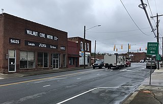
Walnut Cove is a town in Stokes County, North Carolina, United States. The population was 1,536 at the 2020 census.

<span class="mw-page-title-main">Jonesville, North Carolina</span> Town in North Carolina, United States

Jonesville, originally called Allen's Settlement, is the oldest town in Yadkin County, North Carolina, United States. The population was 2,285 at the 2010 census. The town grew by nearly 800 residents in 2001 when it merged with neighboring Arlington. Recognized as the Heart of the Yadkin Valley, Jonesville is a gateway to the Blue Ridge Mountains, the Yadkin Valley Heritage/Cultural Corridor and to local wineries in the Swan Creek AVA and the larger Yadkin Valley AVA, as well as offering access to the Yadkin river.

<span class="mw-page-title-main">Piedmont Triad</span> Region in North Carolina

The Piedmont Triad is a metropolitan region in the north-central part of the U.S. state of North Carolina anchored by three cities: Greensboro, Winston-Salem, and High Point. This close group of cities lies in the Piedmont geographical region of the United States and forms the basis of the Greensboro–Winston-Salem–High Point, NC Combined Statistical Area (CSA). As of 2012, the Piedmont Triad has an estimated population of 1,611,243 making it the 33rd largest combined statistical area in the United States.

<span class="mw-page-title-main">Germanton, North Carolina</span> Census-designated place in North Carolina, United States

Germanton is an unincorporated community and census-designated place (CDP) in Forsyth and Stokes counties in the U.S. state of North Carolina, primarily in Stokes County. As of the 2020 census, the community had a population of 790.

<span class="mw-page-title-main">Yadkin Valley AVA</span>

The Yadkin Valley AVA is an American Viticultural Area that includes land in seven counties of northwestern North Carolina. The AVA encompasses an area of approximately 1,400,000 acres (5,666 km2) in the Yadkin River valley. The Yadkin Valley AVA includes all of Wilkes, Surry, and Yadkin counties, and parts of Davie, Davidson, Forsyth, and Stokes counties. Yadkin Valley is home to 44 wineries.

<span class="mw-page-title-main">North Carolina's 5th congressional district</span> U.S. House district for North Carolina

North Carolina's 5th congressional district covers the central western portion of North Carolina from the Appalachian Mountains to the western suburbs of the Piedmont Triad. The district borders Tennessee and Virginia, with the bulk of its territory in the mountains; it stretches just far enough to the east to grab its share of Forsyth County, home to most of its population.

<span class="mw-page-title-main">Sauratown Mountains</span> Mountain range in North Carolina

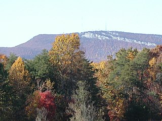
The Sauratown Mountains, which are sometimes called "the mountains away from the mountains", are an isolated mountain range located within Stokes and Surry counties in the U.S. state of North Carolina. The vast majority of the range is located in Stokes County. Although the range occupies only 5% of Stokes County's area, it dominates the county's scenery from almost every direction. The Sauras rise sharply 800 to 1,700 feet above the surrounding terrain.

Westfield in an unincorporated community in Surry and Stokes counties in North Carolina, United States. The community itself is located almost entirely within Surry County, with a small portion extending east into Stokes County. The majority of Westfield's Zip Code Tabulation Area is located within Stokes County.

Donnaha is an unincorporated community along the Yadkin River in the Old Richmond Township of northwest Forsyth County, North Carolina, United States. Donnaha is named for the last chief of the Sauras.

<span class="mw-page-title-main">U.S. Route 52 in North Carolina</span> Section of U.S. Highway in North Carolina, United States

U.S. Route 52 (US 52) is a north–south United States highway that runs for 150 miles (240 km) from the South Carolina state line, near McFarlan, to the Virginia state line, near Mount Airy. It serves as a strategic highway through the central North Carolina Piedmont. Because of its alignment in the state, US 52 does not follow the standard convention of an even U.S. route number going east–west.

<span class="mw-page-title-main">Sauratown Trail</span> Trail in North Carolina, United States

Sauratown Trail is a hiking and bridle trail in Stokes and Surry counties, North Carolina, which crosses the Sauratown Mountains and interconnects Pilot Mountain State Park and Hanging Rock State Park. It is the only bridle trail which goes between two NC State Parks. The trail is located primarily on leased, privately owned lands, and it is the longest publicly open trail on private lands in the state. The trail consists of a main trail of 22.2 miles (35.7 km) and two spur loops each about 6 miles (9.7 km) around. Altogether, the Sauratown Trail and its spurs total over 30 miles (48 km) of trail. The trail was dedicated by the Sauratown Trail Committee in October 1979. Since 2002, most of the main trail has been designated a part of the Mountains-to-Sea Trail.

References

  1. 1 2 3 "QuickFacts: Stokes County, North Carolina". United States Census Bureau. Retrieved March 22, 2024.
  2. "Find a County". National Association of Counties. Retrieved June 7, 2011.
  3. Tucker, Chad (2004). Stokes County. Charleston, SC: Arcadia. p. 10. ISBN   9780738516561 . Retrieved August 8, 2021.
  4. Phillips, Laura A W (1989). "Stokes County Historic Inventory". Final Report for the Stokes County Historical Society.
  5. McGee, William H (1984). "The Great wagon Road: The Route Traveled by the First Settlers in This Area". Unpublished Report.
  6. "Hill, John". NCpedia. Retrieved March 12, 2024.
  7. "2020 County Gazetteer Files – North Carolina". United States Census Bureau. August 23, 2022. Retrieved September 9, 2023.
  8. 1 2 "Monthly Climate Normals for Danbury, North Carolina". Applied Climate Information System. Retrieved October 28, 2018.
  9. "Danbury, North Carolina Köppen Climate Classification". Weatherbase. Retrieved October 28, 2018.
  10. "NCWRC Game Lands". www.ncpaws.org. Retrieved March 30, 2023.
  11. "U.S. Decennial Census". United States Census Bureau. Retrieved January 19, 2015.
  12. "Historical Census Browser". University of Virginia Library. Retrieved January 19, 2015.
  13. Forstall, Richard L., ed. (March 27, 1995). "Population of Counties by Decennial Census: 1900 to 1990". United States Census Bureau. Retrieved January 19, 2015.
  14. "Census 2000 PHC-T-4. Ranking Tables for Counties: 1990 and 2000" (PDF). United States Census Bureau. April 2, 2001. Archived (PDF) from the original on March 27, 2010. Retrieved January 19, 2015.
  15. "State & County QuickFacts". United States Census Bureau. Retrieved October 30, 2013.
  16. "Explore Census Data". data.census.gov. Retrieved December 21, 2021.
  17. "U.S. Census website". United States Census Bureau . Retrieved January 31, 2008.
  18. "About Us". Piedmont Triad Council of Governments. Retrieved January 2, 2023.
  19. "Stokes County". North Carolina Judicial Branch. Retrieved January 11, 2023.
  20. Leip, David. "Dave Leip's Atlas of U.S. Presidential Elections". uselectionatlas.org. Retrieved March 17, 2018.
  21. Menendez, Albert J.; The Geography of Presidential Elections in the United States, 1868-2004, pp. 265-271 ISBN   0786422173
  22. Leip, Dave. "1952 Presidential General Election Results - North Carolina". uselectionatlas.org. Retrieved October 24, 2023.
  23. Caldwell, Neill (November 4, 2020). "Election 2020: Stokes County voters roll out a red carpet". The Stokes News. Retrieved January 3, 2023.
  24. "Leading Employers". Stokes County Economic Development. Retrieved October 24, 2023.
  25. Craver, Richard (November 30, 2022). "Forsyth County ranked in the middle for economic health in NC". Winston-Salem Journal. Retrieved October 24, 2023.
  26. "Directory of Schools". Stokes County Schools. Retrieved September 8, 2022.