Marshall, North Carolina

Last updated

Marshall, North Carolina
17 Marshall, NC.jpg
Main Street
Marshall, NC Town Seal.png
NCMap-doton-Marshall.PNG
Location of Marshall, North Carolina
Coordinates: 35°47′50″N82°40′54″W / 35.79722°N 82.68167°W / 35.79722; -82.68167
Country United States
State North Carolina
County Madison
Area
[1]
  Total4.20 sq mi (10.88 km2)
  Land3.98 sq mi (10.32 km2)
  Water0.22 sq mi (0.57 km2)
Elevation
[2]
1,742 ft (531 m)
Population
 (2020)
  Total777
  Density195.08/sq mi (75.32/km2)
Time zone UTC-5 (Eastern (EST))
  Summer (DST) UTC-4 (EDT)
ZIP code
28753
Area code 828
FIPS code 37-41580 [3]
GNIS feature ID2406103 [2]
Website townofmarshall.org

Marshall is a town in Madison County, North Carolina, United States. The population was 872 at the 2010 census. It is the county seat of Madison County. [4]

Contents

Marshall is part of the Asheville Metropolitan Statistical Area.

The townsite of Marshall is blocked on one side by the French Broad River and on all other sides by steep mountainous terrain. Madison County residents say Marshall is "a block wide, a mile long, sky high and hell deep." [5]

History

The Bank of French Broad, Capitola Manufacturing Company Cotton Yarn Mill, Madison County Courthouse, Marshall High School, Marshall Main Street Historic District, James H. White House, and Jeff White House are listed on the National Register of Historic Places. [6] [7]

During the Civil War, Marshall, as the seat of Confederate administration for Madison County, was the scene of conflict with the largely pro-Union rural population. On May 13, 1861, the election day for delegates to the state convention on secession from the Union, a man shot and killed the pro-secession county sheriff after a dispute in which the sheriff had shot the man's son. [8]

Later, Confederate authorities restricted the distribution of salt, which was needed to preserve meat in the winter. In January 1863, a group of men raided the salt warehouse in Marshall, then proceeded to ransack the home of Colonel Lawrence Allen of the 64th North Carolina Regiment (the columned house below the courthouse dome in the Main Street photo).

In retaliation, the 64th North Carolina Regiment summarily executed 13 men and boys in the Shelton Laurel massacre. [9]

From the 1950s to the 1980s, Marshall was the seat of the Ponder machine, which controlled all the patronage jobs in Madison County.

Geography

According to the United States Census Bureau, the town has a total area of 3.8 square miles (9.8 km2), of which, 3.5 square miles (9.1 km2) is land and 0.3 square miles (0.78 km2) (6.91%) is water. Marshall is located on the eastern bank of the French Broad River, one of the major river systems of western North Carolina.

Demographics

Historical population
CensusPop.Note
1880 175
1890 20316.0%
1900 33766.0%
1910 802138.0%
1920 748−6.7%
1930 1,13251.3%
1940 1,1602.5%
1950 983−15.3%
1960 926−5.8%
1970 9826.0%
1980 809−17.6%
1990 8090.0%
2000 8403.8%
2010 8723.8%
2020 777−10.9%
U.S. Decennial Census [10]

2020 census

Marshall racial composition [11]
RaceNumberPercentage
White (non-Hispanic)69889.83%
Native American 81.03%
Asian 30.39%
Other/Mixed 303.86%
Hispanic or Latino 384.89%

As of the 2020 United States census, there were 777 people, 346 households, and 195 families residing in the town.

2000 census

As of the census [3] of 2000, there were 842 people, 390 households, and 225 families residing in the town. The population density was 240.1 people per square mile (92.7 people/km2). There were 443 housing units at an average density of 126.6 per square mile (48.9/km2). The racial makeup of the town was 98.57% White, 0.48% African American, 0.36% Native American, 0.24% Asian, 0.12% from other races, and 0.24% from two or more races. Hispanic or Latino of any race were 0.60% of the population.

There were 390 households, out of which 23.1% had children under the age of 18 living with them, 39.2% were married couples living together, 15.4% had a female householder with no husband present, and 42.3% were non-families. 37.9% of all households were made up of individuals, and 19.5% had someone living alone who was 65 years of age or older. The average household size was 2.12 and the average family size was 2.81.

In the town, the population was spread out, with 21.7% under the age of 18, 6.8% from 18 to 24, 28.3% from 25 to 44, 22.0% from 45 to 64, and 21.2% who were 65 years of age or older. The median age was 40 years. For every 100 females, there were 85.8 males. For every 100 females age 18 and over, there were 75.5 males.

The median income for a household in the town was $24,188, and the median income for a family was $36,250. Males had a median income of $26,172 versus $22,875 for females. The per capita income for the town was $16,245. About 13.7% of families and 23.4% of the population were below the poverty line, including 29.6% of those under age 18 and 18.8% of those age 65 or over.

In the media

The Amazon Prime Video series The Peripheral shot scenes in the town on September 24, 2021. [12]

Independent filmmakers Joel Haver and Dylan Dexter released the film 31 Days in Marshall, North Carolina in 2019. The film was shot entirely in Marshall in 2017, and features multiple townsfolk in both the cast as well as background musical talent.

Wiley Cash 's 2012 debut novel, A Land More Kind Than Home, is set in Marshall and the surrounding area.

Related Research Articles

<span class="mw-page-title-main">Madison County, North Carolina</span> County in North Carolina, United States

Madison County is a county located in the U.S. state of North Carolina. As of the 2020 census, the population was 21,193. Its county seat is Marshall. Madison County is part of the Asheville, NC Metropolitan Statistical Area.

<span class="mw-page-title-main">Sparta, North Carolina</span> Town in North Carolina, United States

Sparta is a town in Alleghany County, North Carolina, United States. As of the 2020 census, the population of the town was 1,834. It is the county seat of Alleghany County.

<span class="mw-page-title-main">Jefferson, North Carolina</span> Town in North Carolina, United States

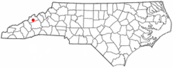
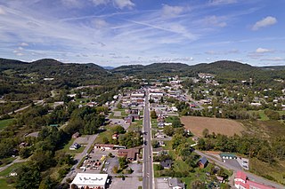
Jefferson is a town in and the county seat of Ashe County, North Carolina, United States. The population was 1,622 at the 2020 U.S. census.

<span class="mw-page-title-main">Mount Pleasant, North Carolina</span> Town in North Carolina, United States

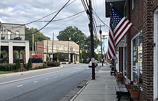
Mount Pleasant is a town located in eastern Cabarrus County, North Carolina, United States. As of the 2010 census, the town population was 1,652. The town center is located at the crossroads of Mount Pleasant Road and North Carolina Highway 73. NC Highway 49 skirts the town to the north on its way from Charlotte to Asheboro.

<span class="mw-page-title-main">Kenansville, North Carolina</span> Town in North Carolina, United States

Kenansville is a town in Duplin County, North Carolina, United States. Its population was 770 at the 2020 census. It is the county seat of Duplin County. The town was named for James Kenan, a member of the North Carolina Senate. Liberty Hall, his early 1800s era historic home, is located within Kenansville.

<span class="mw-page-title-main">Walkertown, North Carolina</span> Town in North Carolina, United States

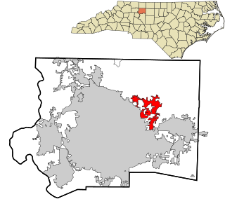
Walkertown is a town in Forsyth County, North Carolina, United States and a rural area outside of Winston-Salem. It is part of the Piedmont Triad. The population was 5,695 at the 2020 census.

<span class="mw-page-title-main">Snow Hill, North Carolina</span> Town in North Carolina, United States

Snow Hill is a town in Greene County, North Carolina, United States. The population was 1,595 at the 2010 census. It is the county seat of Greene County and is part of the Greenville Metropolitan Area. Snow Hill hosts numerous tennis tournaments during the year. Snow Hill is home to the Green Ridge Racquet Club. Many junior players and adults travel to Snow Hill in order to play in the USTA Sanctioned tournaments.

<span class="mw-page-title-main">Walstonburg, North Carolina</span> Town in North Carolina, United States

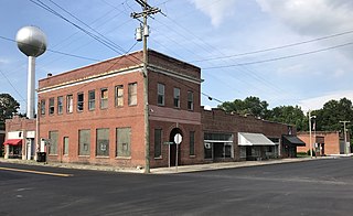
Walstonburg is a town in Greene County, North Carolina, United States. The population was 219 at the 2010 census. It is located north of Snow Hill on North Carolina Highway 91. The town is part of the Greenville Metropolitan Area.

<span class="mw-page-title-main">Summerfield, North Carolina</span> Town in North Carolina, United States

Summerfield is a town in Guilford County, North Carolina. As of the 2020 census, the population was 10,951.

<span class="mw-page-title-main">Angier, North Carolina</span> Town in North Carolina, United States

Angier is a town in the Black River Township of Harnett County, North Carolina, United States. The population was 4,350 at the 2010 census and estimated as of 2018 to be 5,253. Angier is a part of the greater Raleigh–Durham–Cary Combined Statistical Area (CSA) as defined by the United States Census Bureau.

<span class="mw-page-title-main">Winton, North Carolina</span> Town in North Carolina, United States

Winton is a town and the county seat of Hertford County, North Carolina, United States. It is governed by the Town Council which consists of a Mayor and five Council members. The population was 769 at the 2010 census.

<span class="mw-page-title-main">Nashville, North Carolina</span> Town in North Carolina, United States

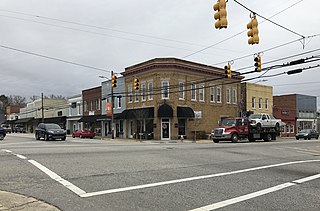
Nashville is a town in Nash County, North Carolina, United States. The town was founded in 1780 and features Victorian and Queen Anne style homes. It is part of the Rocky Mount, North Carolina Metropolitan Statistical Area. The population of Nashville was 5,632 in 2020. It is the county seat of Nash County.

<span class="mw-page-title-main">Carolina Beach, North Carolina</span> Town in North Carolina, United States

Carolina Beach is a beach town in New Hanover County, North Carolina, United States, situated about 12 miles (19 km) south of Wilmington International Airport in southeastern coastal North Carolina. As of the 2020 census, the city population was 6,564. It is part of the Wilmington metropolitan area. The community of Wilmington Beach was annexed by the town in 2000.

<span class="mw-page-title-main">Burgaw, North Carolina</span> Town in North Carolina, United States

Burgaw is a town in, and the county seat of, Pender County, North Carolina, United States. The population was 3,088 at the 2020 census.

<span class="mw-page-title-main">Madison, North Carolina</span> Town in North Carolina, United States

Madison is a town located in Rockingham County, North Carolina. At the 2020 census, the town had a total population of 2,132. Madison is part of the Greensboro-High Point Metropolitan Statistical Area of the Piedmont Triad metro region. It was home to the corporate headquarters of Remington Arms until 2020, when the company was made defunct by bankruptcy proceedings. It is still home to Marlin Firearms, which was an asset of Remington now owned by Sturm, Ruger & Co.

<span class="mw-page-title-main">Mayodan, North Carolina</span> Town in North Carolina, United States

Mayodan is a town in Rockingham County, North Carolina, in the United States. It is a manufacturing site for Sturm, Ruger & Co., Bridgestone Aircraft Tire, and formerly General Tobacco. Washington Mills Company, later Tultex, operated a textile mill in Mayodan until 1999.

<span class="mw-page-title-main">Salemburg, North Carolina</span> Town in North Carolina, United States

Salemburg is a town in Sampson County, North Carolina, United States. The population was 457 at the 2020 census.

<span class="mw-page-title-main">Walnut Cove, North Carolina</span> Town in North Carolina, United States

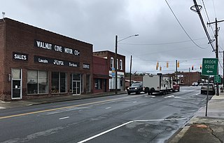
Walnut Cove is a town in Stokes County, North Carolina, United States. The population was 1,536 at the 2020 census.

<span class="mw-page-title-main">Fremont, North Carolina</span> Town in North Carolina, United States

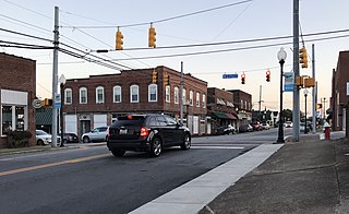
Fremont is a town in Wayne County, North Carolina, United States. The population was 1,255 at the 2010 census. It is included in the Goldsboro, North Carolina Metropolitan Statistical Area.

<span class="mw-page-title-main">Lucama, North Carolina</span> Town in North Carolina, United States

Lucama is a town in Wilson County, North Carolina, United States. The population was 1,108 at the 2010 census.

References

  1. "ArcGIS REST Services Directory". United States Census Bureau. Retrieved September 20, 2022.
  2. 1 2 U.S. Geological Survey Geographic Names Information System: Marshall, North Carolina
  3. 1 2 "U.S. Census website". United States Census Bureau . Retrieved January 31, 2008.
  4. "Find a County". National Association of Counties. Retrieved June 7, 2011.
  5. Pinsky, Mark (April 25, 1994). "The abridgment of Madison County, N.C. : For four decades, the Ponder clan ruled the region as a virtual fiefdom. But a recent voter revolution has the 'dictatorship' in steady decline". Los Angeles Times. Retrieved June 19, 2023.
  6. "National Register Information System". National Register of Historic Places . National Park Service. July 9, 2010.
  7. "National Register of Historic Places Listings". Weekly List of Actions Taken on Properties: 8/27/12 through 8/31/12. National Park Service. September 7, 2012.
  8. Trotter, William R. (1988). Bushwhackers: The Civil War in North Carolina (The Mountains). Winston-Salem, NC: John F. Blair. pp. 9–12. ISBN   0-89587-087-8.
  9. Trotter, William R. (1988). Bushwhackers: The Civil War in North Carolina (The Mountains). Winston-Salem, NC: John F. Blair. pp. 221–232. ISBN   0-89587-087-8.
  10. "Census of Population and Housing". Census.gov. Retrieved June 4, 2015.
  11. "Explore Census Data". data.census.gov. Retrieved December 19, 2021.
  12. Casey, Johnny (May 26, 2021). "New details emerge on upcoming show production to be filmed in Marshall this fall" . Citizen Times. Retrieved June 15, 2021.