MBTA nomenclature

Last updated

The Massachusetts Bay Transportation Authority (MBTA) maintains a large public transit system in the Boston, Massachusetts area, and uses various methods to name and number their services for the convenience of users.

Contents

Subway

The subway system consists of four trunk lines, all of which meet downtown. Each is assigned a color, as follows:

The Red Line has two branches, in the south, called by their terminals – Ashmont and Braintree. Additionally, the Ashmont–Mattapan High Speed Line, a streetcar line to Mattapan, is also colored red. Some trains use the letters A, B, and C for Ashmont, Braintree and Alewife (the north terminal) respectively.

The Green Line is a streetcar/light rail system with four branches to the west, labeled "B" to "E" from north to south. The trains operate underground in the downtown area; outside of downtown, all but the "D" branch run along city streets, with frequent grade crossings at intersections. Rollsigns and newer electronic signs use the following labels:

Subway history

Until 1965, the lines were called by their names:

They were also known by various numbers, used only on maps (see below for more details), as part of an integrated system of rapid transit, streetcars and buses:

After taking over operations in August 1964, the MBTA began rebranding many elements of Boston's public transportation network. On August 26, 1965, the four rapid transit lines were assigned colored names related to their history and geography. The Red Line was named for Harvard University's crimson branding, the Blue Line for passing under Boston Harbor and along Revere Beach, the Green Line for running along the Emerald Necklace, and the Orange Line for running under a section of Washington Street originally known as Orange Street. [1] [2] [3] When designing the rebranding, Cambridge Seven Associates originally planned for yellow instead of orange, but yellow was rejected after testing. [4]

On August 26, 1965, the current colors were assigned. The Green Line branches were lettered A to E in 1967, ending the use of map numbers for the remaining rail routes. The A branch was discontinued in 1969, before lettered rollsigns were ever used on the line. [1] As cars were interchangeable between the Green Line and Ashmont–Mattapan Line, rollsigns also included the letter F for Mattapan service, but this was later changed to M.

On some later rollsigns, short-turn trips were displayed with a slash through the letter. This use included:

Many rollsigns only use the letters for outbound trips, with no letters next to downtown destinations. When the letters were first applied, the inbound destinations all used letters.

The Red Line branches were initially assigned letters in 1968 – A for Quincy/South Braintree and C for Ashmont. At the time, a branch to Brockton was being planned, which might have gotten the letter B. These letters were never used much, and never appeared on maps, and newer rollsigns omitted them. In 1994 the current letter coding was assigned with new cars.

Buses and streetcars

Bus routes are assigned numbers, which are displayed on maps and buses. Generally, the numbers increase from South Boston clockwise to East Boston. Numbers above 202 are used by outlying routes, assigned by region as follows:

The Silver Line Phase I (Washington Street) service have SL4 & SL5. SL5 to Downtown Crossing is internally the 749, as it replaced the 49. The SL4 to South Station is internally 751. The branches of Phase II (South Boston Waterfront) are assigned labels SL1, SL2, and SL3. Shuttles running only to Silver Line Way are not labeled. Internally, the shuttle is 746, and the branches are SL1 as 746.1 or 741 to Logan Airport in East Boston , SL2 as 746.2, or 742 to Design Center in South Boston, and SL3 as 743 to Chelsea.

The two (formerly three) crosstown routes are publicly assigned CT1 to CT3. Internally, they too are given 700-series numbers, based on a parallel route. The former CT1 mostly ran the same route as the 1, so it was the 701. Part of the CT2 parallels the 47, so that part is the 747, and a more recent extension is the 748 (always through-routed). The CT3, paralleling the 8, is the 708, and the former extension was the 709.

Night Owl buses were assigned in the 700 series as well (with a suffix of N). Night Owl buses that replaced other buses were given the normal bus number with N.

Additionally, several private bus companies are subsidized by the MBTA. Some of those are assigned numbers from 710 to 716.

Buses and streetcars history

The 1911 numbering system - this route went along the east side of Franklin Park and ended at Dudley Square with a transfer to the Washington Street Elevated 152 Elevated.jpg
The 1911 numbering system – this route went along the east side of Franklin Park and ended at Dudley Square with a transfer to the Washington Street Elevated

The first numbers used were implemented with Hunter sign boxes, approximately from 1910 to 1917. Numbers were three digits, with the first referring to the division. [5] In 1918, the network was substantially reorganized, and numbers were no longer used. However, from then until 1967, a similar four-digit system was used internally.

Numbers resembling the current system were first assigned on the 1936 map. However, until the 1942 edition, the numbers changed with each new printing as routes were added and removed. In addition, these routes were only used on the map, not even on schedules. From 1942 on, the numbers generally remained the same, with a minor renumbering in 1967 prior to implementing the numbers on rollsigns and schedules.

As the MBTA began to take over suburban bus systems, it assigned them numbers in higher ranges.

The Eastern Massachusetts Street Railway's buses were taken over on March 30, 1968, and numbers were assigned as follows:

The Middlesex and Boston Street Railway buses were subsidized by the MBTA in September 1964, and they were assigned numbers from 20 to 36 (extended to 39 in November 1967, on the takeover of routes from Transit Bus Lines), duplicating existing MBTA numbers. The MBTA took over the M&B on June 30, 1972, and added a 5 in front. The routes were given unused numbers from 52 to 76 in September 1982, and in 1996 the ones operating express to downtown Boston via the Mass Pike were again assigned a 5 in front.

Related Research Articles

<span class="mw-page-title-main">Massachusetts Bay Transportation Authority</span> Public transport agency in the U.S.

The Massachusetts Bay Transportation Authority is the public agency responsible for operating most public transportation services in Greater Boston, Massachusetts. The MBTA transit network includes the MBTA subway with three metro lines, two light rail lines, and a five-line bus rapid transit system ; MBTA bus local and express service; the twelve-line MBTA Commuter Rail system, and several ferry routes. In 2023, the system had a ridership of 239,981,700, or about 755,500 per weekday as of the fourth quarter of 2023, of which the rapid transit lines averaged 267,100 and the light rail lines 80,300, making it the fourth-busiest rapid transit system and the third-busiest light rail system in the United States. As of the fourth quarter of 2023, average weekday ridership of the commuter rail system was 97,100, making it the fifth-busiest commuter rail system in the U.S.

<span class="mw-page-title-main">Transportation in Boston</span> Overview of transportation in Boston, Massachusetts, United States

Transportation in Boston includes roadway, subway, regional rail, air, and sea options for passenger and freight transit in Boston, Massachusetts. The Massachusetts Port Authority (Massport) operates the Port of Boston, which includes a container shipping facility in South Boston, and Logan International Airport, in East Boston. The Massachusetts Bay Transportation Authority (MBTA) operates bus, subway, short-distance rail, and water ferry passenger services throughout the city and region. Amtrak operates passenger rail service to and from major Northeastern cities, and a major bus terminal at South Station is served by varied intercity bus companies. The city is bisected by major highways I-90 and I-93, the intersection of which has undergone a major renovation, nicknamed the Big Dig.

<span class="mw-page-title-main">Red Line (MBTA)</span> Rapid transit line in Massachusetts, US

The Red Line is a rapid transit line operated by the Massachusetts Bay Transportation Authority (MBTA) as part of the MBTA subway system. The line runs south and east underground from Alewife station in North Cambridge through Somerville and Cambridge, surfacing to cross the Longfellow Bridge then returning to tunnels under Downtown Boston. It continues underground through South Boston, splitting into two branches on the surface at JFK/UMass station. The Ashmont branch runs southwest through Dorchester to Ashmont station, where the connecting light rail Ashmont–Mattapan High Speed Line continues to Mattapan station. The Braintree branch runs southeast through Quincy and Braintree to Braintree station.

<span class="mw-page-title-main">Green Line (MBTA)</span> Light rail system

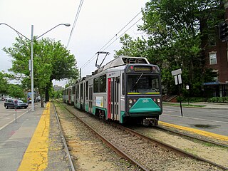
The Green Line is a semi-metro system run by the Massachusetts Bay Transportation Authority (MBTA) in the Boston, Massachusetts, metropolitan area. It is the oldest MBTA subway line, and with tunnel sections dating from 1897, the oldest subway in North America. It runs underground through downtown Boston, and on the surface into inner suburbs via six branches on radial boulevards and grade-separated alignments. With an average daily weekday ridership of 137,700 in 2019, it is the third most heavily used light rail system in the country. The line was assigned the green color in 1967 during a systemwide rebranding because several branches pass through sections of the Emerald Necklace of Boston.

<span class="mw-page-title-main">Ashmont–Mattapan High-Speed Line</span> Light rail line in Boston and Milton, Massachusetts

The Ashmont–Mattapan High-Speed Line, commonly referred to as the Mattapan Trolley, is a partially grade-separated light rail line which forms part of the MBTA's Red Line rapid transit line. The line, which runs through Boston and Milton, Massachusetts, opened on August 26, 1929, as a conversion of a former commuter rail line. It exclusively uses PCC streetcars built in the 1940s. Passengers must transfer at Ashmont to access the rest of the Red Line, which uses heavy rail metro rolling stock.

<span class="mw-page-title-main">JFK/UMass station</span> Transit station in Boston, Massachusetts, US

JFK/UMass station is a Massachusetts Bay Transportation Authority (MBTA) intermodal transfer station, located adjacent to the Columbia Point area of Dorchester, Boston, Massachusetts. It is served by the rapid transit Red Line; the Greenbush Line, Kingston/Plymouth Line, and Middleborough/Lakeville Line of the MBTA Commuter Rail system, and three MBTA bus routes. The station is named for the John F. Kennedy Presidential Library and Museum and the University of Massachusetts Boston, both located nearby on Columbia Point.

<span class="mw-page-title-main">MBTA key bus routes</span> Bus routes utilized and ran by the MBTA

Key bus routes of the Massachusetts Bay Transportation Authority (MBTA) system are 15 routes that have high ridership and higher frequency standards than other bus lines, according to the 2004 MBTA Service Policy. Together, they account for roughly 40% of the MBTA's total bus ridership. These key bus routes ensure basic geographic coverage with frequent service in the densest areas of Boston, and connect to other MBTA services to give access to other areas throughout the region.

<span class="mw-page-title-main">Nubian station</span> Bus and former rapid transit station in Boston, Massachusetts, US

Nubian station is a ground-level Massachusetts Bay Transportation Authority (MBTA) bus station located in Nubian Square in the Roxbury neighborhood of Boston, Massachusetts, United States. It is a transfer point between MBTA bus routes, including two Silver Line bus rapid transit lines and 14 local routes. Like all MBTA bus stops, Nubian is fully accessible.

<span class="mw-page-title-main">Green Line A branch</span> Former streetcar line in Massachusetts, US

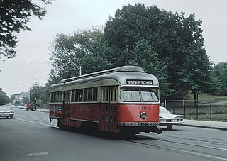
The A branch or Watertown Line was a streetcar line in the Boston, Massachusetts, area, operating as a branch of the Massachusetts Bay Transportation Authority Green Line. The line ran from Watertown through Newton Corner, Brighton, and Allston to Kenmore Square, then used the Boylston Street subway and Tremont Street subway to reach Park Street station.

<span class="mw-page-title-main">Boston-area streetcar lines</span>

As with many large cities, a large number of Boston-area streetcar lines once existed, and many continued operating into the 1950s. However, only a few now remain, namely the four branches of the Green Line and the Ashmont–Mattapan High-Speed Line, with only one running regular service on an undivided street.

<span class="mw-page-title-main">Fields Corner station</span> Rapid transit station in Boston, Massachusetts, US

Fields Corner station is a rapid transit station on the Ashmont branch of the Massachusetts Bay Transportation Authority (MBTA) Red Line, located in the Fields Corner district of Dorchester, Boston, Massachusetts. It is a major transfer point for MBTA bus service, serving routes 15, 17, 18, 19, 201, 202, and 210. The station opened in 1927 and was completely rebuilt from 2004 to 2008, making it fully accessible.

<span class="mw-page-title-main">Ashmont station</span> Rapid transit station in Boston, Massachusetts, US

Ashmont station is a Massachusetts Bay Transportation Authority (MBTA) intermodal transit station located at Peabody Square in the Dorchester neighborhood of Boston, Massachusetts. It is the southern terminus of the Ashmont branch of the rapid transit Red Line, the northern terminus of the connecting light rail Ashmont–Mattapan High-Speed Line, and a major terminal for MBTA bus service. Ashmont has two side platforms serving the below-grade Red Line and a single side platform on an elevated balloon loop for the Mattapan Line. The station is fully accessible for all modes.

<span class="mw-page-title-main">Mattapan station</span> Light rail station in Boston, Massachusetts, US

Mattapan station is an MBTA light rail station in Boston, Massachusetts. It is the southern terminus of the Ashmont–Mattapan High-Speed Line, part of the Red Line, and is also an important MBTA bus transfer station, with eight routes terminating there. It is located at Mattapan Square in the Mattapan neighborhood. At the station, streetcars use a balloon loop to reverse direction back to Ashmont station. Mattapan station is fully accessible, with mini-high platforms.

<span class="mw-page-title-main">Washington Street Elevated</span> Former elevated railroad in Boston, Massachusetts

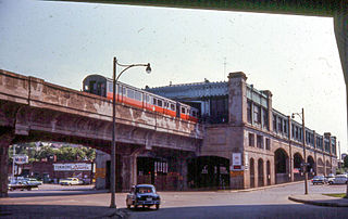
The Washington Street Elevated was an elevated segment of Boston's Massachusetts Bay Transportation Authority subway system, comprising the southern stretch of the Orange Line. It ran from Chinatown through the South End and Roxbury, ending in Forest Hills in Jamaica Plain, Boston.

<span class="mw-page-title-main">Savin Hill station</span> Rapid transit station in Boston, Massachusetts, US

Savin Hill station is a rapid transit station in Boston, Massachusetts. It serves the Ashmont branch of the MBTA's Red Line. It is located at 121 Savin Hill Avenue adjacent to Sydney Street in the Savin Hill area of the Dorchester neighborhood. Opened in 1845 as a commuter rail station, Savin Hill was converted to rapid transit in 1927 and rebuilt in 2004–05 for accessibility. Averaging 2,199 daily boardings by a FY 2019 count, Savin Hill is the least-used station on the Red Line.

<span class="mw-page-title-main">Back of the Hill station</span> Light rail station in Boston, Massachusetts, US

Back of the Hill station is a surface stop on the light rail MBTA Green Line E branch, located in the Mission Hill neighborhood of Boston, Massachusetts. It is named after, and primarily serves, the adjacent Back of the Hill apartment complex, a Section 8 development for elderly and disabled residents. Back of the Hill is located on the street running section of the E branch on South Huntington Avenue. The station has no platforms; passengers wait in bus shelters on the sidewalks and cross a traffic lane to reach Green Line trains.

<span class="mw-page-title-main">MBTA subway</span> Boston region transit service

The Massachusetts Bay Transportation Authority (MBTA) operates rapid transit, light rail, and bus rapid transit services in the Boston metropolitan area, collectively referred to as the rapid transit, subway, or the T system.

<span class="mw-page-title-main">Milton station (MBTA)</span> Light rail station in Milton, Massachusetts, US

Milton station is a light rail station in Milton, Massachusetts. Located in the Dorchester-Milton Lower Mills Industrial District, it serves the MBTA's Ashmont–Mattapan High-Speed Line. This station is accessible via wooden ramps on both platforms.

<span class="mw-page-title-main">Central Avenue station (MBTA)</span> Light rail station in Milton, Massachusetts, US

Central Avenue station is a light rail station located off Central Avenue near Eliot Street in Milton, Massachusetts. It serves the Ashmont–Mattapan High Speed Line, a branch of the MBTA Red Line. Central Avenue consists of two side platforms which serve the Ashmont–Mattapan High Speed Line's two tracks.

References

  1. 1 2 Belcher, Jonathan (26 December 2015). "Changes to Transit Service in the MBTA district 1964-2015" (PDF). NETransit. Retrieved 19 January 2016.
  2. Sanborn, George M. (1992). A Chronicle of the Boston Transit System. Massachusetts Bay Transportation Authority. Archived from the original on 2015-08-18. Retrieved 2016-01-19 via MIT.
  3. "Curiosity Carcards" (PDF). Massachusetts Bay Transportation Authority. Archived from the original (PDF) on 2017-02-18. Retrieved 2016-01-19.
  4. Tran, Andrew Ba (June 2012). "MBTA Orange Line's 111th anniversary". Boston Globe. p. 11. Retrieved 19 January 2016.
  5. "To Number Its Cars". Boston Globe. May 15, 1910. p. 40 via Newspapers.com. Open Access logo PLoS transparent.svg