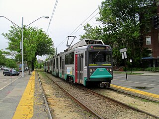
The Green Line is a semi-metro system run by the Massachusetts Bay Transportation Authority (MBTA) in the Boston, Massachusetts, metropolitan area. It is the oldest MBTA subway line, and with tunnel sections dating from 1897, the oldest subway in North America. It runs underground through downtown Boston, and on the surface into inner suburbs via six branches on radial boulevards and grade-separated alignments. With an average daily weekday ridership of 137,700 in 2019, it is the third most heavily used light rail system in the country. The line was assigned the green color in 1967 during a systemwide rebranding because several branches pass through sections of the Emerald Necklace of Boston.

Harvard station is a rapid transit and bus transfer station in Cambridge, Massachusetts. Located at Harvard Square, it serves the MBTA's Red Line subway system as well as MBTA buses. Harvard averaged 18,528 entries each weekday in FY2019, making it the third-busiest MBTA station after Downtown Crossing and South Station. Five of the fifteen key MBTA bus routes stop at the station.
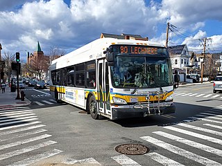
The Massachusetts Bay Transportation Authority (MBTA) operates 152 bus routes in the Greater Boston area. The MBTA has a policy objective to provide transit service within walking distance for all residents living in areas with population densities greater than 5,000 inhabitants per square mile (1,900/km2) within the MBTA's service district. Much of this service is provided by bus. In 2023, the system had a ridership of 91,459,700, or about 303,300 per weekday as of the fourth quarter of 2023.

Lechmere station is a Massachusetts Bay Transportation Authority (MBTA) Green Line light rail station in Lechmere Square in East Cambridge, Massachusetts. It is located on the east side of Monsignor O'Brien Highway near First Street, adjacent to the NorthPoint development. The accessible elevated station has a single island platform, with headhouses at both ends. It opened on March 21, 2022, as part of the Green Line Extension (GLX). Lechmere station is served by Green Line D branch and E branch service.

Hynes Convention Center station is an underground light rail station on the Massachusetts Bay Transportation Authority (MBTA) Green Line. It is located at the intersection of Newbury Street and Massachusetts Avenue near the western end of the Back Bay neighborhood of Boston, Massachusetts. The station is named for the Hynes Convention Center, which is located about 700 feet (210 m) to the east along Boylston Street. It has two side platforms serving the two tracks of the Boylston Street subway, which are used by the Green Line B branch, C branch, and D branch. The main entrance to the station from Massachusetts Avenue leads to a fare lobby under the 360 Newbury Street building.

Key bus routes of the Massachusetts Bay Transportation Authority (MBTA) system are 15 routes that have high ridership and higher frequency standards than other bus lines, according to the 2004 MBTA Service Policy. Together, they account for roughly 40% of the MBTA's total bus ridership. These key bus routes ensure basic geographic coverage with frequent service in the densest areas of Boston, and connect to other MBTA services to give access to other areas throughout the region.
The Middlesex and Boston Street Railway (M&B) was a streetcar and later bus company in the area west of Boston. Streetcars last ran in 1930, and in 1972, the company's operations were merged into the Massachusetts Bay Transportation Authority (MBTA).

The E branch is a light rail line in Boston, Cambridge, Medford, and Somerville, Massachusetts, operating as part of the Massachusetts Bay Transportation Authority (MBTA) Green Line. The line runs in mixed traffic on South Huntington Avenue and Huntington Avenue between Heath Street and Brigham Circle, in the median of Huntington Avenue to Northeastern University, then into the Huntington Avenue subway. The line merges into the Boylston Street subway just west of Copley, running to North Station via the Tremont Street subway. It then follows the Lechmere Viaduct to Lechmere, then the Medford Branch to Medford/Tufts. As of February 2023, service operates on eight-minute headways at weekday peak hours and eight to nine-minute headways at other times, using 13 to 17 trains.

The B branch, also called the Commonwealth Avenue branch or Boston College branch, is a branch of the MBTA Green Line light rail system which operates on Commonwealth Avenue west of downtown Boston, Massachusetts. One of four branches of the Green Line, the B branch runs from Boston College station down the median of Commonwealth Avenue to Blandford Street. There, it enters Blandford Street portal into Kenmore station, where it merges with the C and D branches. The combined services run into the Boylston Street subway and Tremont Street subway to downtown Boston. B branch service has terminated at Government Center since October 2021. Unlike the other branches, the B branch runs solely through the city limits of Boston. The Green Line Rivalry between Boston College and Boston University is named in reference to the B branch, which runs to both universities.
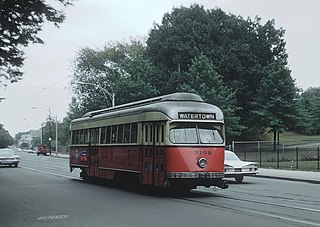
The A branch or Watertown Line was a streetcar line in the Boston, Massachusetts, area, operating as a branch of the Massachusetts Bay Transportation Authority Green Line. The line ran from Watertown through Newton Corner, Brighton, and Allston to Kenmore Square, then used the Boylston Street subway and Tremont Street subway to reach Park Street station.

The Boston-area trolleybus system formed part of the public transportation network serving Greater Boston in the U.S. state of Massachusetts. It opened on April 11, 1936, with a large network operating for the next quarter-century. Measured by fleet size, the Boston-area system was the second-largest trolleybus system in the United States at its peak, with only the Chicago system having more trolleybuses than Boston's 463. After 1963, the only remaining portion was a four-route cluster operating from the Harvard bus tunnel at Harvard station, running through Cambridge, Belmont, and Watertown. The Massachusetts Bay Transportation Authority took over the routes in 1964.
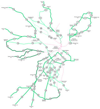
As with many large cities, a large number of Boston-area streetcar lines once existed, and many continued operating into the 1950s. However, only a few now remain, namely the four branches of the Green Line and the Ashmont–Mattapan High-Speed Line, with only one running regular service on an undivided street.
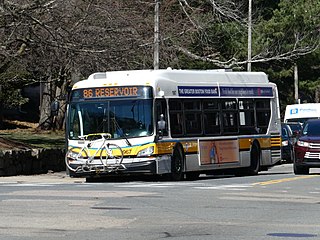
Route 86 is a local bus route in Boston, Cambridge, and Somerville, Massachusetts, operated by the Massachusetts Bay Transportation Authority (MBTA) as part of MBTA bus service. It operates on a circumferential route between Sullivan Square station and Reservoir station via Union Square, Somerville, Harvard Square, and Brighton Center. In 2018, it had the 18th-highest weekday ridership on the system, though it ranked 37th by number of weekday trips. A 2018–19 MBTA review of its bus system found that route 86 had infrequent and unreliable service, including irregular scheduled headways, despite its high ridership and significance as a crosstown connecting route.

Watertown Carhouse is a bus maintenance facility and former streetcar carhouse located in the southern section of Watertown, Massachusetts, across the Charles River from Watertown Square. As Watertown Yard, the site also serves as a bus depot serving local and express routes, with additional connections available at Watertown Square on the opposite end of the Watertown Bridge.
The history of the Massachusetts Bay Transportation Authority (MBTA) and its predecessors spans two centuries, starting with one of the oldest railroads in the United States. Development of mass transportation both followed existing economic and population patterns, and helped shape those patterns.

Babcock Street station is a light rail stop on the Massachusetts Bay Transportation Authority (MBTA) Green Line B branch, located in the median of Commonwealth Avenue in the west part of the Boston University campus. The accessible station has two side platforms serving the line's two tracks, with access at Babcock Street and Pleasant Street.
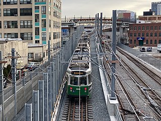
The Green Line Extension (GLX) was a construction project to extend the Massachusetts Bay Transportation Authority (MBTA) Green Line light rail system northwest into Somerville and Medford, two inner suburbs of Boston, Massachusetts. The project opened in two phases in 2022 at a total cost of $2.28 billion. Total ridership on the 4.3-mile (6.9 km) extension is estimated to reach 45,000 one-way trips per day in 2030.

Amory Street station is a light rail stop on the Massachusetts Bay Transportation Authority (MBTA) Green Line B branch, located in the median of Commonwealth Avenue in the west part of the Boston University campus. The accessible station has two side platforms serving the line's two tracks, with access at Amory Street and St. Paul Street.
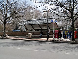
Newton Corner is an MBTA bus transfer point in the Newton Corner neighborhood of Newton, Massachusetts, located on the rotary where Washington Street crosses the Massachusetts Turnpike. The Newton Corner station, known simply as Newton for much of its lifetime, served commuters on the Worcester Line from 1834 to 1959. A streetcar stop, located on the surface streets, served a number of routes beginning in 1863, including the Green Line A branch until 1969. Newton Corner is now a stop and transfer point for MBTA routes 52, 57, 501, 504, 553, 554, 556, and 558, which include express routes to downtown Boston as well as local routes, with stops on the north and south sides of the rotary.

The Conductor's Building is a former Boston Elevated Railway (BERy) administrative building, located on Bennett Alley between Mount Auburn Street and Bennett Street near Harvard Square in Cambridge, Massachusetts. Built in 1912 as the headquarters of BERy's 7th Division, it is the only original building surviving from the construction of the Cambridge subway. After being renovated from 2014 to 2017 as part of an adjacent hotel project, the building was used as a restaurant from April 2017 to August 2018. Under the name Boston Elevated R.Y. Offices, it is a contributing property to the Harvard Square Historic District.


