Mass Rapid Transit Master Plan in Bangkok Metropolitan Region

Last updated
Bangkok Mass Rapid Transit System
SRT Bangkok Commuter Rail Dark Red Line Logo.svg SRT Bangkok Commuter Rail Light Red Line Logo.svg ARLbangkok.svg
BTS-Logo Light Green.svg BTS-Logo Dark Green.svg BTS-Logo Gold.svg
MRT (Bangkok) logo.svg MRT (Bangkok) Purple logo.svg MRT (Bangkok) Pink Logo.svg MRT (Bangkok) Yellow Logo 01.svg

2023versionofbangkokmassrapidtransitmap.png
Map as of Jan 2024
Overview
Owner BMA
MRTA
SRT
Locale Bangkok Metropolitan Region
Transit type Commuter rail
  SRT  
  SRT  
Airport rail link
ARLbangkok.svg   ARL  
Rapid transit
  BTS  
  BTS  
  MRT  
  MRT  
  MRT  (under construction)
Light rail
Silver Line (planned)
Monorail
  MRT  
  MRT  (planned)
  MRT  
  MRL  (planned)
  MRL  (planned)
People Mover
  MRL  
Number of linesCurrent: 10 lines
(Total planned: 15 lines)
Number of stations 190 out of planned 310
Daily ridership1.68 million [1]
Operation
Began operation5 December 1999
Operator(s)S.R.T. Electrified Train
  SRT  
  SRT  
Asia Era One
ARLbangkok.svg   ARL  
Bangkok Mass Transit System
  BTS  
  BTS  
  MRT  
  MRT  
  MRL  
Bangkok Expressway and Metro
  MRT  
  MRT  
  MRT  (likely)
Technical
System length261.47 km (162 mi)
Track gauge MRT, BTS and Airport Rail Link: 1,435 mm (4 ft 8+12 in) standard gauge
SRT Red Lines: 1,000 mm (3 ft 3+38 in) metre gauge
Electrification MRT and BTS: 750 V DC   third rail
ARL and SRT: 25 kV 50 Hz AC overhead catenary
Top speedMRT and BTS: 80 km/h (50 mph)
ARL and SRT: 160 km/h (99 mph)

The Mass Rapid Transit Master Plan in Bangkok Metropolitan Region, or M-Map, is the latest version in a series of Thai government plans for the development of an urban rail transit network serving the Greater Bangkok area. It was drafted under the care of the Office of Transport and Traffic Policy and Planning (OTP) of the Ministry of Transport.

Contents

Lavalin Skytrain Project

Main article: Lavalin Skytrain

Lavalin Skytrain project map Map of the cancelled Lavalin Skytrain.svg
Lavalin Skytrain project map

Lavalin Skytrain Project is the earliest mass rapid transit plan of Bangkok to solve the traffic congestion in Bangkok during 1970s. The project feasibility study was conducted by Thai Government with the association from West Germany Government in 1971 which led to establishment of Expressway Authority of Thailand under Clause 39 of the Announcement of the Revolutionary Council Decree 290 dated 27 November 1972 (B.E.2515) to responsible for planning and construction of expressway and mass rapid transit projects. The finalised version of the project consisted of three light rail transit lines which are Sathorn Line, Rama IV Line, and Saphan Phut Line, with the depot located in Huai Khwang district (current location of Phra Ram 9 depot of MRT Blue Line). The project was expected to begin in 1981 and be completed in 1986. However, due to the 1979 oil crisis, Lavalin Skytrain project was shelved as the estimated costs were doubled.

The project was revised under the government of General Prem Tinsulanonda in 1984 and entered the bidding process with three participating companies being Asia-Euro Consortium (comprising AEG, Siemens, MAN, and Ateliers de Constructions Electriques de Charleroi) [2] , SNC-Lavalin , and Franco-Japanese Consortium. The project was awarded to SNC-Lavalin, and the contracts for a 30-year operating concession and construction were signed in May 1990 at Queen Sirikit National Convention Centre.

However, after two years of construction, In June 1992, The project was terminated by the government of Anand Panyarachun . The government stated that SNC-Lavalin failed to sign a shareholders agreement by a specified and the Thai government refused requests for overseas loan and investment guarantees [3] . Outside of Thailand, numerous international media sources suggested politics played in its demise.

The abandoned viaduct in the middle of the Phra Pok Klao Bridge now serves as the Chao Phraya Sky Park. swnl`yfaa11.jpg
The abandoned viaduct in the middle of the Phra Pok Klao Bridge now serves as the Chao Phraya Sky Park.

Today, There are two remainings from the construction of Lavalin Skytrain project: the abandoned viaduct in the middle of Phra Pok Klao Bridge (now converted into Chao Phraya Skypark) [4] , and a reserved space in the middle of Sathorn Bridge (currently used by Silom Line).

Early versions (Old plans)

Mass Rapid Transit Systems Master Plan (MTMP)

The first version of the plan, endorsed by the cabinet on 27 September 1994 and to be implemented from 1995 to 2011, consisted of an extension of 135 kilometres (84 mi) to the three systems already in progress (the MRT Blue Line, the Sukhumvit and Silom lines of the BTS Skytrain and the Bangkok Elevated Road and Train System (BERTS)), which would have had a combined length of 103 kilometres (64 mi). [5]

Urban Rail Transportation Master Plan in Bangkok and Surrounding Areas (URMAP)

Following the 1997 Asian Financial Crisis and the cancellation of the BERTS, a system totalling 375 kilometres (233 mi) to begin in 2001 was proposed, to be developed in three stages: 141.9 kilometres (88.2 mi) during 2001–11, 158.2 kilometres (98.3 mi) during 2012–21 and 75.3 kilometres (46.8 mi) from 2022 onwards. [5]

Bangkok Mass Transit Master Plan (BMT)

Due to the slow progress of development following URMAP, a new plan was drafted consisting of 475.05 kilometres (295.18 mi) of rail in addition to the then-completed MRT Blue Line, the Sukhumvit and Silom BTS lines, the MRT purple line, and the Airport Rail Link to undergo rapid development during 2010–29. The plan was approved by the cabinet in 2016, and consisted of the following extensions:

M-Map development

Original M-Map (2010)

The M-Map details plans for additional rapid transit lines in Bangkok Metropolitan Region. Bangkok Mass Rapid Transit Map.png
The M-Map details plans for additional rapid transit lines in Bangkok Metropolitan Region.

The first M-Map plan was endorsed by the Commission for the Management of Land Traffic in 2010. [6] It designated eight primary routes, consisting of two commuter rail lines, an airport rail link, and five rapid transit lines, as well as five feeder lines. The routes, totaling 555.74 kilometres (345.32 mi), were to be constructed within a development period of twenty years (2010–29). They were: [7]

Primary lines
Rapid transit typeLineRoute
Heavy rail: Commuter SRT Dark Red Line Thammasat University – Rangsit – Krung Thep Aphiwat – Hua Lamphong – Bang Bon – Maha Chai
SRT Light Red Line Sala Ya – Taling Chan – Hua Mak
Heavy rail: Metro SRT Airport Rail Link Suvarnabhumi – Phaya Thai – Krung Thep Aphiwat – Don Mueang
Heavy rail: Metro BTS Light Green Line and extension of BTSEast Outer Ring Road – Khu Khot – Saphan Mai – Mo Chit – On Nut – Bearing – Kheha Samut Prakan – Bang Pu
BTS Dark Green Line and extension of BTSYot Se – Saphan Taksin – Bang Wa – Taling Chan
MRT Blue Line and extension of MRTTha Phra – Bang Sue – Hua Lamphong – Tha Phra – Lak Song – Phutthamonthon Sai 4
MRT Purple Line Khlong Bang Phai – Tao Poon – Khru Nai
MRT Orange Line Bang Khun Non – Thailand Cultural Centre – Yaek Rom Klao
Feeder lines
Rapid transit typeLineRoute
Monorail MRT Yellow Line Lat Phrao – Samrong
MRT Pink Line Nonthaburi Civic Center – Min Buri
Grey Line Watcharaphon – Rama IX Bridge
Light Blue Line Pracha Songkhro – Chong Nonsi

Development would be divided into three stages, in addition to those lines already open or under construction. [8]

M-Map 2 (2017)

The 2010 M-Map did not reflect more recent changes to the priority of constructing new rapid transit lines in Bangkok. While the Orange, Yellow and Pink lines received approval in the years that followed, the Grey and Light Blue lines remained unapproved at the time of the next M-Map. In March 2017, the Minister of Transport announced the development of the Second Mass Rapid Transit Master Plan in Bangkok Metropolitan Region (M-Map 2). [9] The Office of Transport and Traffic Policy and Planning (OTP) was the main agency responsible for this master plan's development, with technical assistance from the Japan International Cooperation Agency (JICA). [10]

The initial project materials listed the following lines as part of the plan: [11]

Primary lines
Rapid transit typeLineRoute
Heavy rail: Commuter SRT Dark Red Line Thammasat University – Rangsit – Krung Thep Aphiwat – Hua Lamphong – Bang Bon – Maha Chai
SRT Light Red Line Sala Ya – Taling Chan – Hua Mak
Heavy rail: Commuter SRT Airport Rail Link and extensionSuvarnabhumi – Phaya Thai – Krung Thep Aphiwat – Don Mueang
Heavy rail: Metro BTS Light Green Line East Outer Ring Road – Khu Khot – Saphan Mai – Mo Chit – On Nut – Bearing – Kheha Samut Prakan – Bang Pu
BTS Dark Green Line Yot Se – Saphan Taksin – Bang Wa – Taling Chan
MRT Blue Line Tha Phra – Bang Sue – Hua Lamphong – Tha Phra – Lak Song – Phutthamonthon Sai 4
MRT Purple Line Khlong Bang Phai – Tao Poon – Khru Nai
MRT Orange Line Bang Khun Non – Thailand Cultural Centre – Yaek Rom Klao
Feeder lines
Rapid transit typeLineRoute
Monorail MRT Yellow Line Phaholyothin 24 – Lat Phrao – Samrong
MRT Pink Line and Impact Link Spur LineNonthaburi Civic Center – (Si Rat – Mueang Thong Lake) – Min Buri

In 2019, JICA released a Proposed M-MAP2 Blueprint study, outlining "key policy directions and measures based on which the M-MAP2 will be developed by the Thai Government". [12] The Department of Rail Transport, OTP's successor agency for rail transport planning, is in the process of completing M-Map 2. [13] [14]

Lines outside of M-Map 2

As of 2022, the Grey and Light Blue line projects remain unapproved; however, the MRT Brown Line project, which will link Nonthaburi Civic Center with the Lam Sali intersection between Ramkhamhaeng and Srinagarindra roads, has gained cabinet approval. Additionally, a Gold Line along Charoen Nakhon road that starts at Krung Thonburi, partially funded by property developer Siam Piwat, has been operational outside of the M-Map framework since 2020 and is planned to be further extended towards the Memorial Bridge, linking it with the Purple Line extension that runs through the bridge's surrounding area.

Rapid transit typeLineRoute
Monorail BMA Grey Line Watcharaphon – Rama IX Bridge
Light Blue Line Pracha Songkhro – Chong Nonsi
MRT Brown Line Nonthaburi Civic Center – Yaek Lam Sali
Automated guideway transit BMA Gold Line Krung Thonburi – Memorial Bridge
Light rail BMA Silver Line Bang Na – Suvarnabhumi

Overview

Line NameCommencementLast extensionNext extensionTerminusLength

(km)

StationsTrack GaugeDepotSignallingPower SupplyOwnerOperator(s)
Commuter rail
Dark Red Line 29 November 2021;2 years ago [lower-roman 1] -January 2028 [lower-roman 2] Krung Thep Aphiwat Central Terminal Rangsit 22.5 km (14.0 mi)101,000 mm (3 ft 3+38 in)• Bang Sue ETCS Level 1 25 kV AC 50 Hz, overhead line State Railway of Thailand S.R.T. Electrified Train
Light Red Line February 2028 [lower-roman 3] Taling Chan 14.93 km (9.28 mi)4
Airport rail link
Airport Rail Link 23 August 2010;13 years ago [lower-roman 4] -2027 [lower-roman 5] Phaya Thai Suvarnabhumi 28.17 km (17.50 mi)81,435 mm (4 ft 8+12 in)• Khlong TanFixed-block Siemens LZB 700M 25 kV AC 50 Hz, overhead line State Railway of Thailand Previous: S.R.T. Electrified Train
Current: Asia Era One
Rapid Transit
Sukhumvit Line 5 December 1999;24 years ago [lower-roman 6] 16 December 2020;3 years ago [lower-roman 7] TBA Khu Khot Kheha 51.17 km (31.80 mi)471,435 mm (4 ft 8+12 in)• Khu Khot
• Bang Pu
Previous: Fixed-block Siemens LZB 700M ATC
Current: Moving-block Bombardier Cityflo 450 CBTC
750 V DC, Third Rail Bangkok Metropolitan Administration Bangkok Mass Transit System
• Mo Chit
Silom Line 8 February 2021;3 years ago [lower-roman 8] National Stadium Bang Wa 13.09 km (8.13 mi)14
• Bang Wa sub-depot
Blue Line 3 July 2004;19 years ago [lower-roman 9] 23 December 2019;4 years ago [lower-roman 10] Tha Phra Lak Song 46.91 km (29.15 mi)38• Huai Khwang
• Phetkasem
Fixed-block Siemens LZB 700M ATC Mass Rapid Transit Authority of Thailand Bangkok Expressway and Metro
Purple Line 6 August 2016;7 years ago [lower-roman 11] -March 2027 [lower-roman 12] Khlong Bang Phai Tao Poon 20.92 km (13.00 mi)16• Khlong Bang Phai
• Kru Nai (under construction)
Moving-block Bombardier Cityflo 650 CBTC
Monorail
Pink Line 21 November 2023;6 months ago [lower-roman 13] [lower-roman 14] -2025 [lower-roman 15] Nonthaburi Civic Centre Min Buri 33.9 km (21.1 mi)30-• Min BuriMoving-block Bombardier Cityflo 650 CBTC 750 V DC, Third Rail Mass Rapid Transit Authority of Thailand Bangkok Mass Transit System
Yellow Line 3 June 2023;11 months ago [lower-roman 16] 19 June 2023;11 months ago [lower-roman 17] - Lat Phrao Samrong 28.62 km (17.78 mi)23• Si Udom
People Mover
Gold Line 16 December 2020;3 years ago [lower-roman 18] -TBA Krung Thon Buri Khlong San 1.67 km (1.04 mi)31,435 mm (4 ft 8+12 in)• Krung Thon BuriMoving-block Bombardier Cityflo 650 CBTC 750 V DC, Third Rail Bangkok Metropolitan Administration Bangkok Mass Transit System
Total261.88 km (162.72 mi)189 [lower-roman 19]

Future plans

Line NameNamePlanned

opening date

TerminusLength

(km)

StationsStatusOwner
Commuter rail
Dark Red Line Thammasart University (Rangsit Campus) to Ban Pachi Junction SectionTBAThammasart University (Rangsit Campus) Ban Pachi Junction 22 km (14 mi)9Planning State Railway of Thailand
Hua Lamphong to Mahachai Section Hua Lamphong Mahachai 34.76 km (21.60 mi)20
Mahachai to Pak Tho Section Mahachai Pak Tho 78 km (48 mi)17
Rangsit to Thammasart University (Rangsit Campus) SectionJanuary 2028 Rangsit Thammasart University (Rangsit Campus)10.3 km (6.4 mi)4To be tendered
Missing Link SectionTBA Krung Thep Aphiwat Central Terminal Hua Lamphong 7.71 km (4.79 mi)5Approved
Light Red Line Hua Mak 18.2 km (11.3 mi)
Taling Chan to Salaya Section with two additional stations; Rama 6 and EGAT stationsFebruary 2028 Taling Chan Salaya 12.64 km (7.85 mi)6To be tendered
Taling Chan to Siriraj SectionSiriraj5.86 km (3.64 mi)3
Hua Mak to Chachoengsao SectionTBA Hua Mak Chachoengsao 40 km (25 mi)10Planning
Salaya to Nakhon Pathom Section Salaya Nakhon Pathom 29 km (18 mi)6
Ractchaprarop to Mae Nam Section Ratchaprarop Mae Nam6 km (3.7 mi)3
Airport rail link
Airport Rail Link Don Mueang–Suvarnabhumi–U-Tapao high-speed railway (Phaya Thai to Don Mueang section)2029 Phaya Thai Don Mueang 20.31 km (12.62 mi)2Approved State Railway of Thailand
Rapid Transit
Sukhumvit Line Lam Luk Ka ExtensionTBA Khu Khot Eastern Ring Road Lam Luk Ka7.8 km (4.8 mi)4Postponed Mass Rapid Transit Authority of Thailand
Tamru Extension Kheha Tamru10.1 km (6.3 mi)4
Infill station between Ari and Saphan Khwai stationsSena Ruam (N6)-1 Bangkok Metropolitan Administration
Silom Line Yot Se Extension National Stadium Yot Se1.2 km (0.75 mi)1Planning
Taling Chan Extension Bang Wa Taling Chan 7.94 km (4.93 mi)7
Taling Chan to Bang Rak Noi Thai It Section Taling Chan Bang Rak Noi Tha It 8.60 km (5.34 mi)7
Blue Line Putthamonthon Sai 4 Extension Lak Song Putthamonthon Sai 48.3 km (5.2 mi)4Postponed Mass Rapid Transit Authority of Thailand
Purple Line MRT Purple Line Southern SectionMarch 2027 Tao Poon Kru Nai22.78 km (14.15 mi)17Under construction
Orange Line MRT Orange Line Eastern Section2026 Thailand Cultural Centre Yaek Rom Klao21 km (13 mi)17
MRT Orange Line Western Section2029 Bang Khun Non Thailand Cultural Centre 13.1 km (8.1 mi)11To be retendered
Bang Khun Non to Taling Chan SectionTBA Taling Chan Bang Khun Non 4.4 km (2.7 mi)1Approved
Light Rapid Transit
Silver Line Bang Na - Suvarnabhumi light rail projectTBA Bang Na Suvarnabhumi Airport South Terminal20 km (12 mi)14Postponed Bangkok Metropolitan Administration

(to be transferred to Mass Rapid Transit Authority of Thailand)

Monorail
Pink Line Impact Arena Spur Line2025 Muang Thong Thani Lake Muang Thong Thani2.65 km (1.65 mi)2Under construction Mass Rapid Transit Authority of Thailand
Brown Line MRT Brown Line2028 Nonthaburi Civic Centre Yaek Lam Sali 21 km (13 mi)20Approved
Yellow Line Ratchayothin ExtensionTBA Lat Phrao Ratchayothin 2.5 km (1.6 mi)2Shleved
Grey Line Grey Line Northern Section Thong Lo Vatcharaphol 16.25 km (10.10 mi)15Postponed Bangkok Metropolitan Administration

(to be transferred to Mass Rapid Transit Authority of Thailand)

Grey Line Southern Section Phra Khanong Tha Phra 20.2 km (12.6 mi)24
Khlong Si Extension Vatcharaphol Khlong Si10.87 km (6.75 mi)5Planning
Light Blue Line Light Blue Line projectPracha Songkro Chong Nonsi 9.5 km (5.9 mi)9Planning
People Mover
Gold Line Prachadhipok ExtensionTBA Khlong San Prachadhipok1.2 km (0.75 mi)1Postponed Bangkok Metropolitan Administration
Total491.67 km (305.51 mi) [lower-roman 20] 229 [lower-roman 21]

Rolling Stock

NameManufacturerFamily NameLineCars (per train)No. of trainsetsSpeed LimitService

Commencement

Image
1000 Series Flag of Japan.svg Hitachi Rail A-train Dark
Red
Line
Light Red Line 6-car15Dark Red Line: 145 km/h (90 mph)

Light Red Line: 120 km/h (75 mph)

29 November 2021;2 years ago SRTRedline 1000series WiteePhotography. For wikipedia.jpg
2000 Series4-car10 SRTRedline 2000series WiteePhotography. For wikipedia.jpg
Class 360 Flag of Germany.svg Siemens Desiro Airport Rail Link 3-car5145 km/h (90 mph)23 August 2010;13 years ago BKKARL Siemens Desiro UK Class260.2 WiteePhotography. For wikipedia.jpg
4-car4 ARL Bangkok Express1.JPG
A1 Flag of Germany.svg Siemens Modular Metro Sukhumvit Line Silom Line 3580 km/h (50 mph)5 December 1999;24 years ago (THA-Bangkok) BTS 113 @ Ekkamai 2024-02-13.jpg
A2 Flag of Germany.svg Siemens / Flag of Turkey.svg Bozankaya -226 December 2018;5 years ago BTS EMU-A2 arriving at Ha Yaek Lat Phrao Station.jpg
B1 Flag of Canada (Pantone).svg Bombardier Transportation / Flag of the People's Republic of China.svg CRRC Changchun Railway Vehicles MOVIA 12December 2010;13 years ago Bangkok Skytrain 05.jpg
B2529 November 2013;10 years ago
B3 Flag of the People's Republic of China.svg CRRC Changchun Railway Vehicles -2430 November 2019;4 years ago EMU-B3 77.jpg
IBL

(Initial Blue Line)

Flag of Germany.svg Siemens Modular Metro Blue Line 3-car193 July 2004;19 years ago MRT blue Line Train 14 20180917.jpg
BLE

(Blue Line Extension)

-3529 July 2019;4 years ago MRT-BLUELINE-BLE.jpg
S24 Flag of Japan.svg Japan Transport Engineering Company (J-TREC) Sustina Purple Line 216 August 2016;7 years ago MRT Purple Line Train T013 20160806.jpg
Innovia Monorail 300 Flag of Canada (Pantone).svg Bombardier Transportation / Flag of the People's Republic of China.svg CRRC Nanjing Puzhen Innovia Pink Line 4-car3021 November 2023;6 months ago Pink Line at Royal Irrigation Department Station 01.jpg
Yellow Line 283 June 2023;11 months ago Bombardier Innovia Monorail 300 YellowLine YM09 20230902.jpg
Innovia APM 300 Gold Line 2-car316 December 2020;3 years ago (THA-Bangkok) Gold Line APM01 @ Khlong San 2024-02-12 (4).jpg

Overall map

Compilation of plans, proposals, under construction, and operational lines and stations. Bangkok's Metro Plan.png
Compilation of plans, proposals, under construction, and operational lines and stations.

Notes

  1. Krung Thep Aphiwat - Rangsit & Krung Thep Aphiwat - Taling Chan
  2. Rangsit - Thammasat University (Rangsit Campus)
  3. Taling Chan - Salaya & Taling Chan - Siriraj
  4. Phaya Thai - Suvarnabhumi
  5. Phaya Thai - Don Mueang Airport (expected)
  6. Mo Chit - On Nut & National Stadium - Saphan Taksin
  7. Wat Phra Si Mahathat - Khu Khot
  8. Saint Louis station
  9. Bang Sue - Hua Lamphong
  10. Sirindhorn - Tha Phra
  11. Khlong Bang Phai - Tao Poon
  12. Tao Poon - Kru Nai
  13. Nonthaburi Civic Centre - Min Buri
  14. Trial run. Officially open on 1 February 2024;3 months ago
  15. Mueang Thong Thani - Lake Muang Thong Thani
  16. Hua Mak - Samrong
  17. Phawana - Lat Phrao
  18. Krung Thon Buri - Khlong San
  19. Counted paid-to-paid area interchange station only once
  20. excluded Ratchayothin extension
  21. excluded Ratchayothin extension

Related Research Articles

<span class="mw-page-title-main">BTS Skytrain</span> Elevated rapid transit system in Bangkok, Pathum thani and Samut prakan, Thailand

The Bangkok Mass Transit System, commonly known as the BTS Skytrain, is an elevated rapid transit system in Bangkok, Thailand. It is operated by Bangkok Mass Transit System PCL (BTSC), a subsidiary of BTS Group Holdings, under a concession granted by the Bangkok Metropolitan Administration (BMA) which owns the lines. The system consists of 62 stations along three lines with a combined route length of 70.05 kilometers (43.53 mi). The BTS Sukhumvit Line runs northwards and south-eastwards, terminating at Khu Khot and Kheha respectively. The BTS Silom Line which serves Silom and Sathon Roads, the central business district of Bangkok, terminates at National Stadium and Bang Wa. The Gold Line people mover runs from Krung Thon Buri to Klong San and serves Iconsiam. The lines interchange at Siam station and Krung Thon Buri. The system is formally known as "The Elevated Train in Commemoration of HM the King's 6th Cycle Birthday".

<span class="mw-page-title-main">MRT (Bangkok)</span> Thai rapid transit system serving Bangkok

The Metropolitan Rapid Transit or MRT is a mass rapid transit system serving the Bangkok Metropolitan Region in Thailand. The MRT system comprises two fully operational rapid transit lines and one fully operational monorail line (Yellow). One monorail line (Pink) is in trial operation, with another rapid transit line (Orange) under construction. The MRT Blue Line, officially the Chaloem Ratchamongkhon Line, between Hua Lamphong and Bang Sue was the first to open in July 2004 as Bangkok's second metro system. The MRT Blue line is officially known in Thai as rotfaifa mahanakhon (รถไฟฟ้ามหานคร) or "metropolitan electric train", but it is more commonly called rotfai taidin (รถไฟใต้ดิน), literally, "underground train" as it was distinguished from the BTS Skytrain by being completely underground when its first section between Hua Lamphong to Bang Sue opened.

<span class="mw-page-title-main">Chatuchak district</span> Khet in Bangkok, Thailand

Chatuchak is one of the 50 districts (khet) of Bangkok, Thailand. The district is bounded by seven other districts : Lak Si, Bang Khen, Lat Phrao, Huai Khwang, Din Daeng, Phaya Thai, and Bang Sue.

<span class="mw-page-title-main">Silom Line</span> Elevated rapid transit line in Bangkok, Thailand

The BTS Silom Line is an elevated rapid transit line of the BTS Skytrain in Bangkok, Thailand. It is operated by Bangkok Mass Transit System PCL (BTSC), a subsidiary of BTS Group Holdings, under a concession granted by the Bangkok Metropolitan Administration (BMA). The line serves Silom and Sathon Roads, the central business district of Bangkok, terminates at National Stadium and Bang Wa. The line is 14 km in length and consists of 14 stations.

<span class="mw-page-title-main">Rail transport in Thailand</span>

Rail transport plays a crucial role in connecting various regions of Thailand, transporting both goods and passengers through a range of transportation options that include inter-city and commuter rail, mass rapid transit, monorails, and airport rail links. The State Railway of Thailand (SRT) operates a network of intercity railways spanning 4,845.1 kilometers, covering 47 provinces across the country. SRT is committed to developing railway lands through its subsidiary, SRT Asset (SRTA), which focuses on transit-oriented development (TOD) initiatives. The Krung Thep Aphiwat Central Terminal in Bangkok serves as the primary transportation hub for rail transport in Thailand, connecting various types of rail transportation throughout the country. It covers an area of 274,192 square meters, making it the largest railway station in Southeast Asia, and is situated in a new central business district (CBD) that is currently being developed.

<span class="mw-page-title-main">SRT Red Lines</span> Mass rapid rail system in Bangkok and Pathum Thani, Thailand

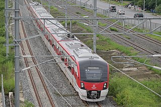
The Red Line Mass Transit System Project is a commuter rail system serving the Bangkok Metropolitan Region in Thailand. Construction began in January 2009, and free public trial operation began on 2 August 2021, when Bang Sue Grand Station opened, with full commercial service starting in November 2021. It is part of the Mass Rapid Transit Master Plan in the Bangkok Metropolitan Region.

<span class="mw-page-title-main">Orange Line (Bangkok)</span> Planned metro line in Bangkok, Thailand

The MRT Orange Line is a rapid transit line of the Mass Rapid Transit Authority of Thailand (MRTA) in the Bangkok Metropolitan Area, Thailand. When fully completed, the MRT Orange line will be 35.9 km (22.3 mi) long with 29 stations, including an interchange with the current Thailand Cultural Centre Station of MRT Blue Line).

The MRT Brown Line is a 22.1 km rapid transit line in Bangkok, Thailand proposed monorail mass transit line from Nonthaburi Civic Centre, Nonthaburi Province to Lam Sali intersection, Bang Kapi District. 20 stations are proposed for the line and the expected cost for the project is 48 billion baht. The line has been integrated for 7.2 km with the N2 expressway project and a feasibility study has been completed. The MRT Brown line will interchange with 7 other mass transit lines.

<span class="mw-page-title-main">SRT Dark Red Line</span> Mass rapid rail line in Bangkok and Pathum thani

The SRT Dark Red Line, is part of the SRT Red Line suburban railway system to serve the greater Bangkok Metropolitan Region running for 26 km (16 mi) between Krung Thep Aphiwat and Rangsit.

<span class="mw-page-title-main">SRT Light Red Line</span> Mass rapid rail in Bangkok, Thailand

The SRT Light Red Line, or Nakhon Withi Line is a 15 km (9.3 mi) between Krung Thep Aphiwat Central Terminal and Taling Chan and is part of the SRT Red Lines suburban railway system serving the greater Bangkok Metropolitan Region.

<span class="mw-page-title-main">Transport in Bangkok</span>

Bangkok has 9.7 million automobiles and motorbikes, a number the government says is eight times more than can be properly accommodated on existing roads. And those numbers are increasing by 700 additional cars and 400 motorbikes every day. Charoen Krung Road, the first road to be built by Western techniques, was completed in 1864. Since then, the road network has expanded to accommodate the sprawling city's needs. Besides roads, Bangkok is served by several other transport systems. Bangkok's canals and ferries historically served as a major mode of transport, but they have long since been eclipsed by land traffic. A complex elevated expressway network and Tollway helps bring traffic into and out of the city centre, but Bangkok's rapid growth has put a large strain on infrastructure. By the late-1970s, Bangkok became known as "the city of traffic disaster". Although rail transport was introduced in 1893 and electric trams served the city from 1894 to 1968, it was only in 1999 that Bangkok's first rapid transit system began operation. Older public transport systems include an extensive bus network and boat services which still operate on the Chao Phraya and two canals. Taxis appear in the form of cars, motorcycles, and tuk-tuks.

<span class="mw-page-title-main">Bangkok BRT</span> Bus rapid transit system in Bangkok, Thailand

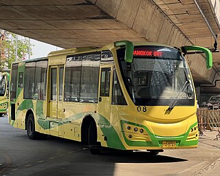
The Bangkok BRT is a bus rapid transit system in Bangkok, Thailand. Out of the five routes that were originally planned, only one line has been in operation since 2010, with all the other routes cancelled. At the end of April 2017, Bangkok Metropolitan Administration (BMA) announced the whole system might be cancelled due to low ridership and financial losses, however a subsequent opinion survey carried out by the BMA found there was a demand for the service to be retained. In March 2017 the Governor of Bangkok announced the service would continue, with increased ticket prices and changed operator to Bangkok Mass Transit System Public Company Limited.

The BMA Grey Line is a planned monorail line in the north of Bangkok to be built from Watcharaphon to Thong Lo. The route would provide a vital north - south link for a distance of 16.25 km with 15 planned stations and is expected to cost 27 billion baht. The line would support the growth of residential areas around Pradit Monutham Rd and Kaset-Namawin rd corridors and is forecast to eventually have 370,000 passengers per day. The BMA Grey with interchange with other lines including the MRT Pink Line, the proposed MRT Brown Line, the MRT Yellow Line, MRT Orange Line and BTS Sukhumvit Line.

The Light Blue Line is a planned monorail line to be built in Bangkok, Thailand. Its path runs along a north–south axis. This line would link the Din Daeng housing community areas, Bangkok City Hall 2, Makkasan Station, and the business area along Sathon Road.

<span class="mw-page-title-main">Rail transport in Bangkok</span>

Rail transport was introduced to Bangkok in 1893, and the national railway network was developed during the 20th century. Modern rapid transit in Bangkok includes several rail systems: the BTS Skytrain which opened in 1999, followed by the MRT, Airport Rail Link and SRT Red Lines.

<span class="mw-page-title-main">Greater Bangkok commuter rail</span> Commuter rail system in Bangkok

Greater Bangkok commuter rail is a commuter rail system in Bangkok Metropolitan Region, Phra Nakhon Si Ayutthaya Province, Saraburi Province, Lopburi Province, Suphan Buri Province, Ratchaburi Province, Chacheongsao Province, Nakhon Nayok Province, Prachinburi Province, and Samut Songkhram Province. It runs from and to the outskirts of the city during the rush hour, and the passenger number is high. It is operated by State Railway of Thailand (SRT) that also operates inter-city rail. Commuter rail services always have number 3xx. Most of the system are double track.

The BMA Bang Na–Suvarnabhumi line is a proposed light rail line in Bangkok that would run from Bang Na junction to Suvarnabhumi Airport. The line was first proposed in 1994, but it was not included in the 2005 OTP Mass Rapid Transit Master Plan. Initially, it was planned for the line to potentially be a BTS Sukhumvit Line branch line with turnouts constructed near Bang Na junction. In December 2015, the BMA said it would advance construction and would propose it to cabinet in the near future. In April 2016, deputy governor Amorn Kitchawengkul said the project would take 3–6 years and cost THB 20 billion.

<span class="mw-page-title-main">Gold Line (Bangkok)</span> Automated People Mover (APM) line in Bangkok, Thailand

The Gold Line is an automated people mover line, part of Bangkok's rapid transit system. The line is 1.8 km (1.1 mi) long, consisting of 3 stations, and was opened by Thai Prime Minister Prayut Chan-o-cha on 16 December 2020. It primarily serves as a feeder line between the BTS Silom line and Iconsiam shopping center. The line will be extended 1 km (0.62 mi) along Somdet Chao Phraya road to connect with the future MRT Purple Line southern extension. When completed, it will connect Krung Thon Buri BTS station with Prajadhipok Road in Thon Buri District for a total distance of 2.68 km (1.67 mi).

References

  1. "นิวไฮ! 25 ส.ค. ฝนตก-ศุกร์สิ้นเดือน ผู้โดยสารระบบรางพุ่ง 1.75 ล้านคน".
  2. cnplus (1990-05-24). "25May90 THAILAND: ASIA-EURO CONSORTIUM MAY SUE THAI GOVT". Construction News. Retrieved 2024-05-20.
  3. "Report Thailand to terminate contract for Bangkok 'skytrain' - UPI Archives". UPI. Retrieved 2024-05-20.
  4. Voraakhom, Kotchakorn (10 November 2022). "Chao Phraya Sky Park". world-architects.com. Retrieved 20 May 2024.
  5. 1 2 เส้นทางปรับแผนรถไฟฟ้า. Mass Rapid Transit Master Plan in Bangkok Metropolitan Region website (in Thai). Office of Transport and Traffic Policy and Planning. Archived from the original on 2 January 2011. Retrieved 16 January 2012.
  6. Hoonsara, Samatcha; Jeerawan Prasomsap (9 February 2010). "Commission approves new Skytrain routes". The Nation. Archived from the original on 2011-02-21. Retrieved 16 January 2012.
  7. แผนแม่บทระบบขนส่งมวลชนทางรางในเขตกรุงเทพฯและปริมณฑล พ.ศ.2553-2572 [Mass Rapid Transit Master Plan in Bangkok Metropolitan Region](PDF) (in Thai). Office of Transport and Traffic Policy and Planning. Retrieved 16 January 2012.
  8. ความก้าวหน้าโครงการ. Mass Rapid Transit Master Plan in Bangkok Metropolitan Region website (in Thai). Office of Transport and Traffic Policy and Planning. Archived from the original on 11 January 2012. Retrieved 16 January 2012.
  9. ไทย-ญี่ปุ่น เร่งศึกษาแผนแม่บทรถไฟฟ้า. banmuang.co.th (in Thai). Retrieved 2017-08-12.
  10. "Outline of the Project: Project for enhancing capacity of formulation of the Second Mass Rapid Transit Master Plan in Bangkok Metropolitan Region (M-MAP2)". Japan International Cooperation Agency. Retrieved 12 October 2022.
  11. "Development of the 2nd Blueprint for Bangkok Mass Rapid Transit Master Plan (M-MAP2)" (PDF). Archived from the original (PDF) on 2020-11-11.
  12. "Data Collection Survey on the Development of Blueprint for the Second Mass Rapid Transit. Master Plan. (M-Map2) in The Kingdom of Thailand" (PDF). Japan International Cooperation Agency. Retrieved 12 October 2022.
  13. "กรมรางฯลุยศึกษา 'M-MAP' ระยะที่ 2 เติมโครงข่ายรถไฟฟ้าครอบคลุมกรุงเทพฯ-ปริมณฑล". Thai Post. March 2022.
  14. "แนะนำโครงการ-M-MAP" (PDF). Department of Rail Transport.