
New Haven is a coastal city in the U.S. state of Connecticut. It is located on New Haven Harbor on the northern shore of Long Island Sound in New Haven County, Connecticut, and is part of the New York metropolitan area. With a population of 129,779 as determined by the 2010 United States Census, it is the second-largest city in Connecticut after Bridgeport. New Haven is the principal municipality of Greater New Haven, which had a total population of 862,477 in 2010.
Hamden is a town in New Haven County, Connecticut, United States. The town's nickname is "The Land of the Sleeping Giant". The population was 60,960 at the 2010 census. Hamden is a suburb of the city of New Haven.
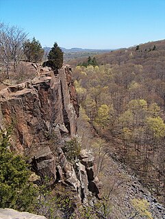
East Rock of south-central Connecticut, United States, with a high point of 366 feet (112 m), is a 1.4-mile (2 km) long trap rock ridge located primarily in the neighborhood of East Rock on the north side of the city of New Haven. A prominent landscape feature and a popular outdoor recreation area with cliffs that rise 300 feet (91 m) over the city below, East Rock is part of the narrow, linear Metacomet Ridge that extends from Long Island Sound near New Haven, north through the Connecticut River Valley of Massachusetts to the Vermont border. East Rock is the central feature of East Rock Park, a municipal park owned by the city of New Haven along the New Haven-Hamden town line.
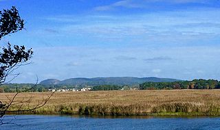
Sleeping Giant is a rugged traprock mountain with a high point of 739 feet (225 m), located eight miles (13 km) north of New Haven, Connecticut. A prominent landscape feature visible for miles, the Sleeping Giant receives its name from its anthropomorphic resemblance to a slumbering human figure as seen from either the north or south. The Giant is known for its expansive clifftop vistas, rugged topography, and microclimate ecosystems. Most of the Giant is located within Sleeping Giant State Park. The mountain is a popular recreation site: over 30 miles (48 km) of hiking trails traverse it including 5 miles (8 km) of the 23-mile (37 km) Quinnipiac Trail. Quinnipiac University is located at Mount Carmel's foot in Hamden.

Regicides Trail is a Blue-Blazed hiking trail, about 7 miles (11 km) long, roughly following the edge of a diabase, or traprock, cliff northwest of New Haven, Connecticut. It is named for two regicides, Edward Whalley and his son-in-law William Goffe, who signed the death warrant of King Charles I of England. Upon the restoration of Charles II to the throne and the persecution of the regicides, the pair hid in Judges Cave near the south end of the trail in 1660.
The Mill River is a river in New Haven County, Connecticut.

Route 40, also known as the Mount Carmel Connector, is a 3.08-mile (4.96 km) spur route from Interstate 91 in North Haven, Connecticut connecting I-91 and Bailey Road in North Haven to Route 10 in the Mount Carmel neighborhood of Hamden. Route 40 is a 4-lane freeway with one intermediate exit leading to / from U.S. Route 5 in North Haven. It crosses over Route 15 but does not have an interchange with it. This is the only place in the state where two freeways cross without an interchange.

Route 22 is a 14.07-mile-long (22.64 km) secondary state route within the U.S. state of Connecticut. Route 22 is an L-shaped road that is signed east–west from Hamden to the western junction of Route 80 in North Branford, and north–south to its eastern terminus in Guilford. It was designated in 1951 as a bypass of New Haven, connecting the Wilbur Cross Parkway and Route 80.
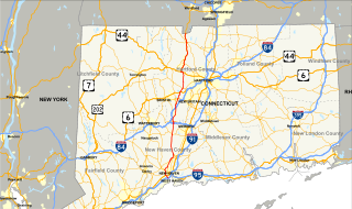
Connecticut Route 10 is a state highway that runs between New Haven and the state line near Granby.

U.S. Route 5 (US 5), a north–south U.S. Highway that is generally paralleled by Interstate 91 (I-91), begins at the city of New Haven in Connecticut and heads north through western Massachusetts and eastern Vermont to the international border with Canada. Within Connecticut, US 5 proceeds north from New Haven and passes through Meriden and Hartford towards Springfield, Massachusetts.

Whitneyville is a neighborhood in the southeastern portion of the town of Hamden, Connecticut. It started in the early nineteenth century as a factory town for workers in Eli Whitney's gun factory. Around the turn of the twentieth century, it evolved into a trolley suburb of New Haven. Today it is primarily residential, with a mixture of single-family homes and small apartment and condominium buildings. There is some commercial development centered around the intersection of Whitney and Putnam avenues.
The Quinnipiac Trail is a 24-mile (39 km) Blue-Blazed hiking trail in New Haven County, Connecticut. It is the product of the evolution and growth of the first 10.6-mile (17.1 km) trail designated in Connecticut's Blue-Blazed Hiking Trail system, with its light-blue rectangular vertical painted blazes.

West Rock Ridge or West Rock of south-central Connecticut, is a 7-mile (11 km) long trap rock mountain ridge located on the west side of New Haven with a high point of 700 feet (213 m). The ridge forms a continuous line of exposed cliffs visible from metropolitan New Haven and points west. West Rock Ridge is part of the narrow, linear Metacomet Ridge which extends from Long Island Sound near New Haven north through the Connecticut River Valley of Massachusetts to the Vermont border.
Newhallville is a neighborhood in the city of New Haven, Connecticut, named for industrialist George Newhall.

The Farmington Canal Heritage Trail is an 81.2-mile (130.7 km) multi-use rail trail located in Connecticut and Massachusetts.

The Mount Carmel Congregational Church and Parish House is a historic church complex at 3280 and 3284 Whitney Avenue and 195 Sherman Avenue in Hamden, Connecticut. It consists of an 1840 Greek Revival church with a tetrastyle temple front portico, a 1911 Colonial Revival parish house, and a 1925 sexton's house. The church is considered to be Hamden's finest example of Greek Revival architecture, and the parish house one of its finest Colonial Revival houses. The property was listed on the National Register of Historic Places in 1991.
Whitney Avenue is a principal arterial connecting Downtown New Haven with the town center of Hamden in the U.S. state of Connecticut. Most of the road within the city of New Haven is included in the Whitney Avenue Historic District, which is listed on the National Register of Historic Places. The designation begins at Grove Street in the northern part of Downtown New Haven and extends through the town of Hamden up to the Cheshire town line. North of Dixwell Avenue in Hamden Center, the road is a state highway and designated as part of Route 10. From the New Haven town line to Dixwell Avenue, the road is state-maintained with an unsigned designation of State Road 707. Within New Haven, Whitney Avenue is a town road. The J route of Connecticut Transit New Haven, which connects New Haven to Waterbury, runs along Whitney Avenue.
Farmington Canal State Park Trail is a Connecticut state park forming a portion of the Farmington Canal Heritage Trail in the towns of Cheshire and Hamden. The developed section of the trail within state park boundaries runs over 17.0 miles (27.4 km) from Lazy Lane in Southginton to Todd Street in Hamden and includes the historic Farmington Canal's restored Lock 12, located south of Brooksvale Road in Cheshire. The paved, multiple-use trail is used for hiking, biking, jogging, in-line skating and cross-country skiing.
Centerville, originally spelled Centreville, is a neighborhood in the east-central portion of the town of Hamden, Connecticut. It is the location of Hamden Town Hall and other major town government buildings. It derived its name from being at the intersection of the town's two principal thoroughfares, Whitney and Dixwell avenues, both with commercial development. The rest of the neighborhood is residential, with single-family houses, condominiums, and apartments.

Highwood is a neighborhood in the south-central portion of the town of Hamden, Connecticut. It is primarily residential, with a mixture of small apartment buildings and single-family, two- and three-family homes. Commercial development is concentrated on its principal street, Dixwell Avenue. Immigrants from Germany were the first to settle the area extensively in the 1860s, followed by others from Ireland, Italy, and Eastern Europe later in the nineteenth century. Today it is predominantly African American.
