
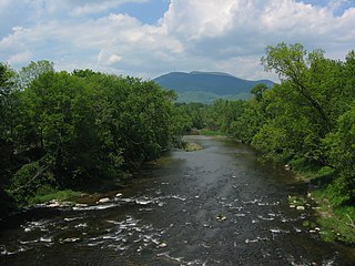
Westmore is a town in Orleans County, Vermont, United States. The population was 357 at the 2020 census, making it the least populated and least densely populated town in the county. The town contains one unincorporated village clustered around Lake Willoughby.

Mount Monadnock, or Grand Monadnock, is a mountain in the towns of Jaffrey and Dublin, New Hampshire. It is the most prominent mountain peak in southern New Hampshire and is the highest point in Cheshire County. It lies 38 miles (61 km) southwest of Concord and 62 miles (100 km) northwest of Boston. At 3,165 feet (965 m), Mount Monadnock is nearly 1,000 feet (305 m) higher than any other mountain peak within 30 miles (48 km) and rises 2,000 feet (610 m) above the surrounding landscape. Monadnock's bare, isolated, and rocky summit provides expansive views. It is known for being featured in the writings of Ralph Waldo Emerson and Henry David Thoreau.

The Blue Ridge Parkway is a National Parkway and All-American Road in the United States, noted for its scenic beauty. The parkway, which is the longest linear park in the U.S., runs for 469 miles (755 km) through 29 counties in Virginia and North Carolina, linking Shenandoah National Park to Great Smoky Mountains National Park. It runs mostly along the spine of the Blue Ridge, a major mountain chain that is part of the Appalachian Mountains. Its southern terminus is at U.S. Route 441 (US 441) on the boundary between Great Smoky Mountains National Park and the Qualla Boundary of the Eastern Band of Cherokee Indians in North Carolina, from which it travels north to Shenandoah National Park in Virginia. The roadway continues through Shenandoah as Skyline Drive, a similar scenic road which is managed by a different National Park Service unit. Both Skyline Drive and the Virginia portion of the Blue Ridge Parkway are part of Virginia State Route 48 (SR 48), though this designation is not signed.

Mount Mansfield is the highest mountain in Vermont with a summit that peaks at 4,393 feet (1,339 m) above sea level. The summit is located within the town of Underhill in Chittenden County; the ridgeline, including some secondary peaks, extends into the town of Stowe in Lamoille County, and the mountain's flanks also reach into the town of Cambridge.
Mount Ascutney is a mountain in the U.S. state of Vermont. At 3,144 feet (958 m), it is the highest peak in Windsor County. Mount Ascutney is a monadnock that rises abruptly from the surrounding lowlands. For example, the Windsor Trail is 2.7 miles (4.3 km) to the summit with 2,514 feet (766 m) of elevation gain and an overall 18% grade. Particularly noteworthy are the mountain's granite outcrops, one of which, near the summit, serves as a launching point for hang-gliders.
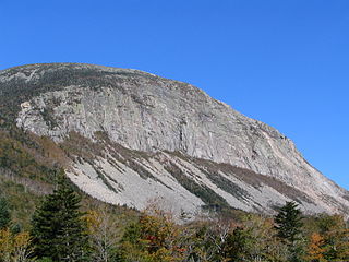
Cannon Mountain is a 4,080-foot (1,240 m) peak in the White Mountains of New Hampshire. It is known for both its technical rock and ice climbing on its cliff face and skiing at Cannon Mountain Ski Area. It was also home to the Old Man of the Mountain, until that formation collapsed on May 3, 2003.

The Alum Cave Trail, also known as Alum Cave Bluff Trail, is a hiking trail in the Great Smoky Mountains National Park, in Sevier County, Tennessee. The trail ascends Mount Le Conte, the sixth highest mountain east of the Mississippi River, and passes by many notable landmarks, such as Arch Rock, Inspiration Point, and the Duckhawk Peaks before merging with Rainbow Falls Trail near the summit.

Ragged Mountain, est. 761 feet (232 m), is a traprock mountain ridge located 3 miles (5 km) west of New Britain, Connecticut, in the towns of Southington and Berlin, Connecticut. It is part of the narrow, linear Metacomet Ridge that extends from Long Island Sound near New Haven, Connecticut, north through the Connecticut River Valley of Massachusetts to the Vermont border. The mountain, a popular hiking and rock climbing attraction located between metropolitan Hartford and Meriden, is known for expansive vistas, vertical cliff faces, mountain ridge reservoirs, unique microclimate ecosystems, and rare plant communities. Ragged Mountain is traversed by the 51-mile (82 km) Metacomet Trail.

The Metacomet-Monadnock Trail is a 114-mile-long (183 km) hiking trail that traverses the Metacomet Ridge of the Pioneer Valley region of Massachusetts and the central uplands of Massachusetts and southern New Hampshire. Although less than 70 miles (110 km) from Boston and other large population centers, the trail is considered remarkably rural and scenic and includes many areas of unique ecologic, historic, and geologic interest. Notable features include waterfalls, dramatic cliff faces, exposed mountain summits, woodlands, swamps, lakes, river floodplain, farmland, significant historic sites, and the summits of Mount Monadnock, Mount Tom and Mount Holyoke. The Metacomet-Monadnock Trail is maintained largely through the efforts of the Western Massachusetts Chapter of the Appalachian Mountain Club (AMC). Much of the trail is a portion of the New England National Scenic Trail.

The Devil's Path is a hiking trail in the Greene County section of the Catskill Mountains of New York, sometimes described as one of the more challenging trails in the New York Tri-state area. It goes across the eponymous mountain range and then three other peaks to the west, offering hikers and peakbaggers a chance to reach the summits of five of the 35 Catskill High Peaks. It draws hikers from not just the region but far outside, due to the challenging climbs straight up and down the steep gaps between the four peaks of the range, which often require hikers to use hands as well as feet to pull themselves almost straight up cliffs and through rocky chutes. These climbs, however, lead to views across the Catskill range.

Lake Willoughby is located in the town of Westmore in Orleans County in the Northeast Kingdom of Vermont, United States.

Giant Mountain, also known as Giant of the Valley, is a mountain in the Adirondacks in the U.S. state of New York. It is the twelfth-highest peak in New York, with an elevation of 4,627 feet (1,410 m), and one of the 46 High Peaks in Adirondack Park. It is located in the Giant Mountain Wilderness Area, in the town of Keene in Essex County. The mountain is named for its towering appearance from the nearby Pleasant Valley to the east, which sits at a low elevation.
Mount Hor is a mountain in Sutton, Vermont. It is part of the Northeastern Highlands of Vermont. It is located on the west side of Lake Willoughby and constitutes the west side of "Willoughby Notch". There are hiking trails in Willoughby State Forest.

Sugarloaf Mountain or Mount Sugarloaf, is a butte-like mountain located in South Deerfield, Massachusetts, United States, with two summits, North Sugarloaf Mountain 791 ft (241 m) and its more popular knee, South Sugarloaf Mountain 652 ft (199 m). Its cliffs, made of arkose sandstone, are a very prominent landscape feature visible for miles. Despite low elevations relative to the Berkshire Mountains to the west, dramatic cliff faces and a rise of 500 feet (150 m) to 600 feet (180 m) from the nearby Connecticut River make the mountain a popular tourist and hiking destination. Sugarloaf Mountain is the southern terminus of the Pocumtuck Range.

Besek Mountain also known as Black Mountain, est. 840 feet (260 m), is a traprock mountain ridge located 4.75 miles (7.6 km) southeast of Meriden, Connecticut. It is part of the narrow, linear Metacomet Ridge that extends from Long Island Sound near New Haven, Connecticut, north through the Connecticut River Valley of Massachusetts to the Vermont border. Besek Mountain is known for its 3-mile (4.8 km) long line of open cliffs, unique microclimate ecosystems, and rare plant communities. The mountain is traversed by the 51-mile (82 km) Mattabesett Trail, and is home to the Powder Ridge Ski Area.

Saltonstall Mountain, also known as Saltonstall Ridge, with a high point of (est.) 320 feet (98 m) above sea level, is a traprock mountain ridge located 3 miles (5 km) east of New Haven, Connecticut and 1.75 miles (2.8 km) north of Long Island Sound. It is part of the Metacomet Ridge that extends from Long Island Sound near New Haven, Connecticut, north through the Connecticut River Valley of Massachusetts to the Vermont border. Saltonstall Mountain is known for its 100 foot (30 m) scenic cliff faces and sharp ridgeline, unique microclimate ecosystems, rare plant communities, and for Lake Saltonstall, a 3 miles (5 km) long by 0.3 miles (400 m) wide municipal reservoir nearly enclosed by the mountain. Saltonstall Mountain is traversed by a number of hiking trails managed by the South Central Connecticut Regional Water Authority (SCCRWA) and Branford Land Trust.

West Rock Ridge or West Rock of south-central Connecticut, is a 7-mile (11 km) long trap rock mountain ridge located on the west side of New Haven with a high point of 700 feet (213 m) at High Rock, also known as York Mountain. The ridge forms a continuous line of exposed cliffs visible from metropolitan New Haven and points west. West Rock Ridge is part of the narrow, linear Metacomet Ridge which extends from Long Island Sound near New Haven north through the Connecticut River Valley of Massachusetts to the Vermont border.

Tully Mountain, 1,163 ft (354 m), is a prominent, steep-sided monadnock located in north central Massachusetts in the town of Orange. It is part of the Tully Mountain Wilderness Management Area. An exposed east facing ledge on the summit provides views of the Millers River valley, Mount Monadnock, Mount Wachusett, and the Wapack Range. The 22-mile (35 km) Tully Trail traverses the mountain.

The Mount Adams Recreation Area is a 21,000-acre (8,500 ha) recreation area in the U.S. state of Washington managed by the Yakama Nation Tribal Forestry Program. The area encompasses an ecologically complex and geologically active landscape. The region features the most rugged side of Mount Adams, including canyons and the Great Gap section of the Mount Adams circumnavigation route, a three-mile trail-less section over two great canyons and many difficult glacial creeks. At 12,276 feet (3,742 m), Mount Adams is one of the major Cascade mountains. The recreation area is on the east side of the mountain and is part of the Yakama Indian Reservation and includes the popular Bird Creek Meadows area.

Willoughby State Forest covers 7,682 acres (31.09 km2) in Newark, Sutton and Westmore in Caledonia and Orleans counties in Vermont. The forest is managed by the Vermont Department of Forests, Parks, and Recreation. Activities include hiking, primitive camping, cross country skiing, snowshoeing, hunting and fishing.

