
The Green Mountains are a mountain range in the U.S. state of Vermont. The range runs primarily south to north and extends approximately 250 miles (400 km) from the border with Massachusetts to the border with Quebec, Canada. The part of the same range that is in Massachusetts and Connecticut is known as The Berkshires or the Berkshire Hills and the Quebec portion is called the Sutton Mountains, or Monts Sutton in French.

Killington Peak is the second highest summit in the Green Mountains and in the U.S. state of Vermont. It is located east of Rutland in south-central Vermont. Killington Peak is a stop on the Long Trail, which here shares its route with the Appalachian Trail. Traveling southbound on the Trail, it is the last 4,000-foot (1,200 m) peak close to the trail until Virginia.

Mount Frissell, 2,454 feet (748 m), which straddles the border of southwest Massachusetts and northwest Connecticut, is a prominent peak of the Taconic Range.

Killington Mountain Resort & Ski Area is a ski resort in Rutland County, Vermont, United States, near the town of Killington. It is the largest ski area in the eastern U.S., and has the largest vertical drop in New England at 3,050 feet. Starting in the 2013–14 ski season, it was given the title "Beast of the East."
The Appalachian National Scenic Trail spans fourteen U.S. states during its roughly 2,200 miles (3,500 km)-long journey: Georgia, North Carolina, Tennessee, Virginia, West Virginia, Maryland, Pennsylvania, New Jersey, New York, Connecticut, Massachusetts, Vermont, New Hampshire, and Maine. The southern end is at Springer Mountain, Georgia, and it follows the ridgeline of the Appalachian Mountains, crossing many of its highest peaks and running almost continuously through wilderness before reaching the northern end at Mount Katahdin, Maine.

Dorset Mountain located in Vermont, on the border of Rutland and Bennington counties, is a mountain of the Taconic Range. The highest summit of Dorset Mountain is within the town of Danby. An unmaintained hiking trail ascends Dorset Peak from the southwest.

Mendon Peak is a mountain located in Rutland County, Vermont. The mountain is a spur off the west side of the Coolidge Range of the Green Mountains, and stands within the Calvin Coolidge State Forest. It is flanked to the east by Little Killington. Mendon Peak is on the Appalachian Mountain Club's list of the "Hundred Highest" peaks in New England. The summit is trailless and several different approaches are possible.
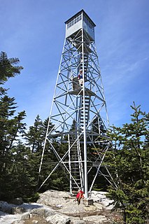
Stratton Mountain is a mountain located in Windham County, Vermont, in the Green Mountain National Forest. The mountain is the highest point of Windham County, and of the southern Green Mountains generally. A fire tower located on the summit is generally open for climbing by the public. There is also a small caretaker cabin at the summit that is inhabited in season by a caretaker from the Green Mountain Club.
Glastenbury Mountain is a mountain located in Bennington County, Vermont, in the Green Mountain National Forest. The mountain is part of the Green Mountains.
The Appalachian Gap is a mountain pass in the Green Mountains of Vermont. The highest point of the pass is located in Chittenden County, about 0.2 mi (0.32 km) west of the boundary between Chittenden and Washington County. The pass is in the Camel's Hump State Park.

Shrewsbury Peak is a mountain located in Rutland County, Vermont, in the Calvin Coolidge State Forest. The mountain is part of the Coolidge Range. Shrewsbury is flanked to the northwest by Little Killington.
Mount Raimer, 2,572 feet (784 m), is a prominent peak in the Taconic Mountains of western Massachusetts and adjacent New York. The west side and summit are located in New York; the east slopes lie within Massachusetts. The summit ridge is part meadow and part wooded with red spruce, balsam fir, and northern hardwood tree species. It is notable for its views of the Hoosic River valley and Hudson River Valley. The 35 mi (56 km) Taconic Crest Trail traverses the mountain. Much of the upper slopes and summit are within protected conservation land. The mountain is the location of a defunct ski area.

Mount Fray, 1,893 feet (577 m), also known as Catamount because of the Catamount Ski Area located on its north slope, is a prominent peak of the south Taconic Mountains, located in southwest Massachusetts and adjacent New York. The summit is open and covered in scrub oak; it offers views west over the Hudson River Valley. The sides of the mountain are wooded with northern hardwood tree species. The 15.7 mi (25.3 km) South Taconic Trail passes over the summit of Mount Fray.
Honwee Mountain, east summit 2,313 feet (705 m) and west summit 2,280 feet (690 m), is a prominent mountain in the Taconic Mountains of western Massachusetts. The mountain is located in Pittsfield State Forest. The east (highest) summit is traversed by the Honwee Circuit multi-use trail. The west summit is crossed by the 35 mi (56 km) Taconic Crest hiking trail and the 12.1 mi (19.5 km) multi-use Taconic Skyline Trail. The mountain is wooded with northern hardwood forest species.

Pico Mountain Ski Area is a ski area located in Killington, Vermont, United States. Established in 1937, it was one of the first commercial ski resorts in the state. The base of the resort is located on the northwest side of Pico Peak on U.S. Route 4 approximately 9 miles northeast of Rutland, Vermont, and 3 mi (5 km) north of Killington Peak. The site lies just inside the town line that separates Killington from the Town of Mendon, to its west. The mountain now features 58 trails and 7 lifts with a 1,967-foot (600-meter) vertical drop.

Sherburne Pass, is a mountain pass in the Green Mountains of Vermont, between 3,957-foot (1,206 m) Pico Peak to the south and 2,782-foot (848 m) Deer Leap Mountain to the north. The height of land of the pass is located in the town of Killington, while its western ascent begins in the town of Mendon.

Gifford Woods State Park is a state park located at the base of Pico Peak in Killington, Vermont. The wooded park provides camping, picnic, and fishing facilities, and has hiking trails, including a portion of the Appalachian Trail. It preserves an area of old-growth forest that has been designated a National Natural Landmark, and is accessible via an interpretive trail. The park was established in 1931. Part of it is listed on the National Register of Historic Places, for facilities developed by the Civilian Conservation Corps in the 1930s.
Calvin Coolidge State Forest, also known as Coolidge State Forest, covers 22,564 acres (91.31 km2) in two parts in Rutland and Windsor Counties in Vermont. The West portion cover 17,259 acres (69.84 km2) in Killington, Mendon, Plymouth and Shrewsbury in both counties. The East portion cover 5,305 acres (21.47 km2) in Bridgewater, Plymouth, Reading, and Woodstock in Windsor County.
Stark Mountain is a mountain in the Green Mountains in the U.S. state of Vermont. Located in the town of Fayston in Washington County, the mountain summit is 3,662 feet (1,116 m) in elevation. Stark Mountain is named after General John Stark, hero of the Battle of Bennington fought in 1777.
Mount Roosevelt is a mountain in the Green Mountains in the U.S. state of Vermont. Located in the Breadloaf Wilderness of the Green Mountain National Forest, its summit is in the town of Ripton in Addison County. The mountain is named after Theodore Roosevelt, former president of the United States. Mount Roosevelt is one of five peaks in Vermont's Presidential Range.
