
The Golden Quadrilateral is a national highway network connecting several major industrial, agricultural and cultural centres of India. It forms a quadrilateral with all the four major metro cities of India forming the vertices, viz., Delhi (north), Kolkata (east), Mumbai (west) and Chennai (south). Other major cities connected by this network include Ahmedabad, Bengaluru, Balasore, Bhadrak, Bhubaneswar, Cuttack, Berhampur, Durgapur, Guntur, Jaipur, Kanpur, Pune, Kolhapur, Surat, Vijayawada, Eluru, Ajmer, Vizag, Bodhgaya, Varanasi, Prayagraj, Agra, Mathura, Dhanbad, Gandhinagar, Udaipur, and Vadodara. The main objective of these super highways is to reduce the travel time between the major cities of India, running roughly along the perimeter of the country. The North–South corridor linking Srinagar and Kanyakumari, and East–West corridor linking Silchar (Assam) and Porbandar (Gujarat) are additional projects. These highway projects are implemented by the National Highway Authority Of India (NHAI). At 5,846 kilometres (3,633 mi), it is the largest highway project in India and the fifth longest in the world. It is the first phase of the National Highways Development Project (NHDP), and consists of two, four, and six-lane express highways, built at a cost of ₹600 billion (US$7.5 billion). The project was planned in 1999, launched in 2001, and was completed in July 2013.
Pataudi is a town and one of the 4 sub-divisions of Gurugram district, in the Indian state of Haryana, within the boundaries of the National Capital Region of India. Ahirs/Yadav dominate the area. It is located 28 km (17.4 mi) from Gurugram, at the foot hills of the Aravali hills.
Rewari is a city and a municipal council in Rewari district in the Indian state of Haryana. It is district headquarter of Rewari district. It is located in south-west Haryana around 82 km from Delhi and 51 km from Gurgaon. It lies in Ahirwal region.
Bawal is a big industrial town located, near Rewari city in Rewari district in Indian state of Haryana. It lies in the National Capital Region (NCR) of India. It is located on national highway NH 48, 11 km from Rewari, the district headquarter, 50 km from Gurugram and 91 km from New Delhi railway station. Bawal Tehsil is a part of the Rewari district. It was one of the three districts of the erstwhile Nabha State under British Raj.
Nangal Choudhary is a town and tehsil in District Mahendragarh at Narnaul in India. A famous personality, Baba Ramdev, belongs to the village which is a part of this region.

Joya is a nagar panchayat located along highway NH-24 in Amroha district in the Western Uttar Pradesh. It is predominantly a milk producing city. Joya was a gram panchayat before 1988. The late Abrar Hussain was the first chairman of Joya in 1988.
Delhi, a major metropolitan region of India, is connected to various parts of country through several national highways and expressways. All the highways and expressways from Delhi lead to Haryana or Uttar Pradesh and continue from there.
The Western Peripheral Expressway (WPE) or Kundli–Manesar–Palwal Expressway, is an operational 6-lane, 135.6 km (84.3 mi)-long Expressway in the Haryana state of India. Along with the Eastern Peripheral Expressway, the Western Peripheral Expressway is expected to divert more than 50,000 heavy vehicles away from Delhi, which will help to maintain good air quality in Delhi. Western Peripheral Expressway along with Eastern Peripheral Expressway completes the largest Ring Road around Delhi. There are 10 tolled entries and exits, from north to south - Kundli, Kharkhoda, Bahadurgarh, Badli, Fartukhnagar, Panchgaon, Manesar, Taoru, Sohna & Palwal. Toll rate notified in December 2018 is INR1.35 per km for cars, INR2.18 per km for light motor vehicles, INR4.98 per km for trucks and buses, and two wheelers are not permitted on the expressway.
Northern Peripheral Road or NH 248-BB, commonly known as Dwarka Expressway is a 27.6 km (17.1 mi) long, under construction, 8-lane, elevated grade separated expressway connecting Dwarka in Delhi to Kherki Daula Toll Plaza, Gurgaon in Haryana. The expressway will take off from km 20 of NH 48 at Shiv Murti in Mahipalpur in Delhi and terminate at km 40 of NH 48 near Kherki Daula Toll Plaza in Gurgaon in Haryana. The NPR has been planned as an alternate road link between Delhi and Gurgaon, and is expected to ease the traffic situation on the Delhi-Gurgaon Expressway. The expressway was initially planned to be 18 km (11 mi) long and was expected to open by 2012 but land acquisition issues delayed the project.
Kherki Daula is a village in Gurgaon on National Highway 48 (India). Its Pincode is 122004. It is mainly inhabited by Ahirs(Yadav). It is opposite to Haldiram's near to second toll plaza from Delhi to Jaipur national highway and in Sector 84 of Gurgaon. This village has now become a village of rich villagers due to sale of their land in Gurgaon. The costliest real estate project "Vatika" is near to this village.
The Bharatmala Pariyojna is an ecosystem of road development which includes development of tunnels, bridges, elevated corridors, flyovers, overpass, interchanges, bypasses, ring roads etc. to provide shortest, jam free & optimized connectivity to multiple places, it is a centrally-sponsored and funded Road and Highways project of the Government of India. Bharatmala is mainly focused on connecting remote areas and satellite cities of megacities such as Bengaluru, Pune, Hyderabad etc. The total investment for 83,677 km (51,994 mi) committed new highways is estimated at ₹10.63 lakh crore (US$130 billion), making it the single largest outlay for a government road construction scheme. The project will build highways from Maharashtra, Gujarat, Rajasthan, Punjab, Haryana and then cover the entire string of Himalayan territories - Jammu and Kashmir, Himachal Pradesh, Uttarakhand - and then portions of borders of Uttar Pradesh and Bihar alongside Terai, and move to West Bengal, Sikkim, Assam, Arunachal Pradesh, and right up to the Indo-Myanmar border in Manipur and Mizoram. Special emphasis will be given on providing connectivity to far-flung border and rural areas including the tribal and backward areas. Bharatmala Project will interconnect 550 District Headquarters through a minimum 4-lane highway by raising the number of corridors to 50 and move 80% freight traffic to National Highways by interconnecting 24 logistics parks, 66 inter-corridors (IC) of total 8,000 km (5,000 mi), 116 feeder routes (FR) of total 7,500 km (4,700 mi) and 7 north east Multi-Modal waterway ports.
National Highway 48 is a National Highway of India that starts at Delhi and terminates at Chennai traversing through seven states of India. It has a total length of 2807 km. NH 48 passes through the states of Delhi, Haryana, Rajasthan, Gujarat, Maharashtra, Karnataka and Tamil Nadu.
Delhi–Jaipur Highway or NH48 is a 242-kilometre-long (150 mi), eight-lane, Highway, connecting Delhi with Jaipur in India. It starts from Kherki Toll Plaza in Gurugram and terminate near Daulatpura Toll Plaza at Jaipur.
The Delhi–Mumbai Expressway is a 1,350 km long, 8-lane wide under-construction access-controlled expressway connecting India's national capital New Delhi with its financial capital Mumbai. Foundation stone of the project was laid by union minister Nitin Gadkari in presence of Sushma Swaraj and Arun Jaitley on 8 March 2019. The total project value including the land acquisition cost is around ₹1,00,000 crores. An additional 31 km long spur will also be constructed by the NHAI from Noida International Airport in Jewar to Sector-65, Faridabad on this expressway.
The Trans–Haryana Expressway or the Ambala–Narnaul Expressway (NH-152D) is a 227-km long, 6-lane wide greenfield access-controlled expressway, connecting the cities of Ambala and Narnaul in the state of Haryana. The expressway connects Gangheri village in Kurukshetra district with Surana village on Narnaul Bypass (NH-148B) in Mahendragarh district. It passes via Kaul, Pundri, Assandh, Dhatrath, Kalanaur, Charkhi Dadri and Kanina. It will reduce the distance from Chandigarh to Delhi, Narnaul, and Jaipur, thus decongesting NH-44 and NH-48.
National Highway 352W, commonly referred to as Gurgaon-Pataudi Road or NH 352W is a national highway in India. It is a spur road of National Highway 352 from Narwana to Rewari, which itself is a spur road of National Highway 52. NH 352W traverses only one state, the state of Haryana in India.
Sohna Elevated Corridor or Sohna–Gurgaon road is a 21.65 km (13.45 mi) long, access controlled, six-lane wide elevated corridor in Gurgaon district of Haryana, India. The project has been completed by the National Highways Authority of India (NHAI) at an estimated cost of ₹1,466 crore. It was fully opened for public on 11 July 2022.
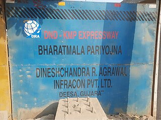
DND–Faridabad–KMP Expressway (NH-148NA) is an under-construction 59 km long, 6-lane wide access-controlled expressway in Delhi NCR, India. It will connect the junction of DND Flyway and Ring Road at Maharani Bagh in Delhi with KMP Expressway at Khalilpur, Nuh district in Haryana. Initially it was a separate expressway, but now it is a part of Delhi–Mumbai Expressway project. This expressway will have an additional 31 km long spur link from Sector-65, Faridabad bypass to Jewar Airport.
Delhi–Ahmedabad High Speed Rail Corridor is an approved high-speed rail line connecting India's capital Delhi with the city of Ahmedabad. When completed, it will be India's second high-speed rail line. It is also said to be an extension of Mumbai–Ahmedabad HSR corridor.
Urban Extension Road-II or NH-344M is an upcoming 75.7 km long, 6 lanes & 4 lanes wide access-controlled expressway in Delhi NCR, India. It would start from National Highway 44 at Alipur then passes from Rohini, Mundka, Najafgarh, Dwarka and end at Delhi–Gurgaon Expressway on National Highway 48 near Mahipalpur. Its main route forms a semicircle on the western side of Delhi, additionally it has two side spurs - one from Bawana in Northwest Delhi to Sonipat in Bawana's North and second in west Delhi from between Tikri border & Najafgarh to NH9 Bahadurgarh south bypass. Delhi NCT has 4 concentric ring roads around it - namely Inner Ring Road; Outer Ring Road; third ring outside it formed by the combination of UER-II & Chilla-Okhla Expressway, and fourth ring formed by the combination of part of Dwarka Expressway & Gurugaon-Ghata Expressway, Gurgaon-Sohna Elevated Corridor Expressway, Sohna-Faridabad section of Delhi-Mumbai Expressway, Faridabad–Noida–Ghaziabad Expressway (FNG), Ghaziabad-Narela Expressway (planned) and Rai-Narela-Bahadurgarh-Gurgaon Expressway. Outside these ring roads, NCR region will have 3 Regional Circular Expressways and 3 Zonal Circular Expressways (ZCE).


