National Register of Historic Places listings in Hamlin County, South Dakota

Last updated
Location of Hamlin County in South Dakota Map of South Dakota highlighting Hamlin County.svg
Location of Hamlin County in South Dakota

This is a list of the National Register of Historic Places listings in Hamlin County, South Dakota.

Contents

This is intended to be a complete list of the properties on the National Register of Historic Places in Hamlin County, South Dakota, United States. The locations of National Register properties for which the latitude and longitude coordinates are included below, may be seen in a map. [1]

There are 15 properties listed on the National Register in the county.

This National Park Service list is complete through NPS recent listings posted December 23, 2021. [2]
Map all coordinates using: OpenStreetMap  
Download coordinates as: KML

Current listings

[3] Name on the Register [4] ImageDate listed [5] Location City or townDescription
1 Bryant Masonic Lodge 118 March 26, 2020
(#100005110)
204 East Main St.
44°35′26″N97°27′47″W / 44.5905°N 97.4630°W / 44.5905; -97.4630 (Bryant Masonic Lodge 118)
Bryant
2 Estelline Bandstand and Gazebo Park November 30, 1999
(#99001434)
105 N. Main
44°34′22″N96°54′09″W / 44.572778°N 96.9025°W / 44.572778; -96.9025 (Estelline Bandstand and Gazebo Park)
Estelline
3 First National Bank of Norden
First National Bank of Norden First National Bank Of Norden NRHP 05001189 Hamlin County, SD.jpg
First National Bank of Norden
October 26, 2005
(#05001189)
503 Main Ave.
44°34′56″N97°12′37″W / 44.582222°N 97.210278°W / 44.582222; -97.210278 (First National Bank of Norden)
Lake Norden
4 First State Bank of Hazel February 21, 1997
(#97000147)
Main St. west of its junction with Highway 22
44°45′33″N97°22′55″W / 44.759167°N 97.381944°W / 44.759167; -97.381944 (First State Bank of Hazel)
Hazel
5 Garfield Church and Cemetery February 15, 2012
(#12000036)
Northwest corner of SD 28 & 443rd Ave.
44°35′16″N97°21′05″W / 44.587793°N 97.351325°W / 44.587793; -97.351325 (Garfield Church and Cemetery)
Bryant vicinity
6 Hamlin County Courthouse
Hamlin County Courthouse Hamlin County Courthouse Hayti.jpg
Hamlin County Courthouse
October 12, 2000
(#00001225)
300 4th St.
44°39′25″N97°12′13″W / 44.657034°N 97.203500°W / 44.657034; -97.203500 (Hamlin County Courthouse)
Hayti
7 M. O. Hanson Building
M. O. Hanson Building M. O. HANSON BUILDING, CASTLEWOOD, HAMLIN COUNTY, SD.JPG
M. O. Hanson Building
July 28, 2011
(#11000486)
126 E. Main St.
44°43′19″N97°02′09″W / 44.721944°N 97.035833°W / 44.721944; -97.035833 (M. O. Hanson Building)
Castlewood
8 Hendrick and Waldur Hendrickson Farm November 13, 1985
(#85003485)
Highway 28
44°35′06″N97°15′26″W / 44.585°N 97.257222°W / 44.585; -97.257222 (Hendrick and Waldur Hendrickson Farm)
Lake Norden
9 Hoffelt Drug Store
Hoffelt Drug Store Hoffelt Drug Store - 2017.jpg
Hoffelt Drug Store
February 19, 2008
(#08000050)
212 Main St.
44°34′35″N96°54′08″W / 44.576389°N 96.902222°W / 44.576389; -96.902222 (Hoffelt Drug Store)
Estelline
10 Kant Hotel October 31, 1985
(#85003449)
North of Highway 28
44°35′26″N97°28′04″W / 44.590556°N 97.467778°W / 44.590556; -97.467778 (Kant Hotel)
Bryant
11 Charles and Mary Lohr House July 19, 1982
(#82003927)
1705 State Ave.
44°34′23″N96°53′37″W / 44.573056°N 96.893611°W / 44.573056; -96.893611 (Charles and Mary Lohr House)
Estelline
12 Old St. Mary's Catholic Parish House December 27, 1988
(#88002840)
5th Ave. and Underwood St.
44°35′19″N97°27′57″W / 44.588611°N 97.465833°W / 44.588611; -97.465833 (Old St. Mary's Catholic Parish House)
Bryant
13 South Dakota Dept. of Transportation Bridge No. 29-221-060 December 9, 1993
(#93001291)
Local road over the Big Sioux River
44°42′59″N97°02′41″W / 44.716389°N 97.044722°W / 44.716389; -97.044722 (South Dakota Dept. of Transportation Bridge No. 29-221-060)
Castlewood Replaced
14 South Dakota Dept. of Transportation Bridge No. 29-279-010 December 9, 1993
(#93001292)
Local road over Stray Horse Creek
44°47′24″N96°55′35″W / 44.79°N 96.926389°W / 44.79; -96.926389 (South Dakota Dept. of Transportation Bridge No. 29-279-010)
Castlewood
15 Jacob and Amelia Tuohino Farm November 13, 1985
(#85003495)
South of Highway 28
44°34′29″N97°18′39″W / 44.574722°N 97.310833°W / 44.574722; -97.310833 (Jacob and Amelia Tuohino Farm)
Lake Norden

See also

Related Research Articles

National Register of Historic Places listings in Campbell County, South Dakota

This is a list of the National Register of Historic Places listings in Campbell County, South Dakota.

National Register of Historic Places listings in Clark County, South Dakota

This is a list of the National Register of Historic Places listings in Clark County, South Dakota.

National Register of Historic Places listings in Corson County, South Dakota

This is a list of the National Register of Historic Places listings in Corson County, South Dakota.

National Register of Historic Places listings in Davison County, South Dakota

This is a list of the National Register of Historic Places listings in Davison County, South Dakota.

National Register of Historic Places listings in Day County, South Dakota

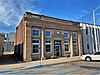
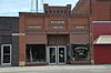
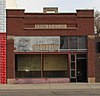
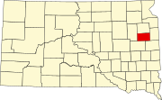
This is a list of the National Register of Historic Places listings in Day County, South Dakota.

National Register of Historic Places listings in Deuel County, South Dakota

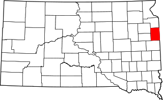
This is a list of the National Register of Historic Places listings in Deuel County, South Dakota.

National Register of Historic Places listings in Douglas County, South Dakota

This is a list of the National Register of Historic Places listings in Douglas County, South Dakota.

National Register of Historic Places listings in Faulk County, South Dakota

This is a list of the National Register of Historic Places listings in Faulk County, South Dakota.

National Register of Historic Places listings in Hanson County, South Dakota

This is a list of the National Register of Historic Places listings in Hanson County, South Dakota.

National Register of Historic Places listings in Hyde County, South Dakota

This is a list of the National Register of Historic Places listings in Hyde County, South Dakota.

National Register of Historic Places listings in Jackson County, South Dakota

This is a list of the National Register of Historic Places listings in Jackson County, South Dakota.

National Register of Historic Places listings in Jones County, South Dakota

This is a list of the National Register of Historic Places listings in Jones County, South Dakota.

National Register of Historic Places listings in Kingsbury County, South Dakota

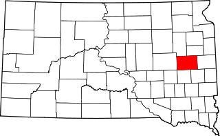
This is a list of the National Register of Historic Places listings in Kingsbury County, South Dakota.

National Register of Historic Places listings in Lyman County, South Dakota

This is a list of the National Register of Historic Places listings in Lyman County, South Dakota.

National Register of Historic Places listings in Marshall County, South Dakota

This is a list of the National Register of Historic Places listings in Marshall County, South Dakota.

National Register of Historic Places listings in McCook County, South Dakota

This is a list of the National Register of Historic Places listings in McCook County, South Dakota.

National Register of Historic Places listings in Miner County, South Dakota

This is a list of the National Register of Historic Places listings in Miner County, South Dakota.

National Register of Historic Places listings in Potter County, South Dakota

This is a list of the National Register of Historic Places listings in Potter County, South Dakota.

National Register of Historic Places listings in Stanley County, South Dakota

This is a list of the National Register of Historic Places listings in Stanley County, South Dakota.

National Register of Historic Places listings in Tripp County, South Dakota

This is a list of the National Register of Historic Places listings in Tripp County, South Dakota.

References

  1. The latitude and longitude information provided in this table was derived originally from the National Register Information System, which has been found to be fairly accurate for about 99% of listings. Some locations in this table may have been corrected to current GPS standards.
  2. National Park Service, United States Department of the Interior, "National Register of Historic Places: Weekly List Actions", retrieved December 23, 2021.
  3. Numbers represent an alphabetical ordering by significant words. Various colorings, defined here, differentiate National Historic Landmarks and historic districts from other NRHP buildings, structures, sites or objects.
  4. "National Register Information System". National Register of Historic Places . National Park Service. April 24, 2008.
  5. The eight-digit number below each date is the number assigned to each location in the National Register Information System database, which can be viewed by clicking the number.