National Register of Historic Places listings in Ottawa County, Oklahoma

Last updated

Location of Ottawa County in Oklahoma Map of Oklahoma highlighting Ottawa County.svg
Location of Ottawa County in Oklahoma

This is a list of the National Register of Historic Places listings in Ottawa County, Oklahoma.

Contents

This is intended to be a complete list of the properties and districts on the National Register of Historic Places in Ottawa County, Oklahoma, United States. The locations of National Register properties and districts for which the latitude and longitude coordinates are included below, may be seen in a map. [1]

There are 19 properties and districts listed on the National Register in the county.


    This National Park Service list is complete through NPS recent listings posted June 24, 2022. [2]

Map all coordinates using: OpenStreetMap  
Download coordinates as: KML

Current listings

[3] Name on the Register [4] ImageDate listed [5] Location City or townDescription
1 Cities Service Station February 23, 1995
(#95000039)
Junction of 1st St. and Central Ave.
36°41′33″N94°57′56″W / 36.69255°N 94.9656°W / 36.69255; -94.9656 (Cities Service Station)
Afton
2 Coleman Theatre
Coleman Theatre Coleman Theater interior.jpg
Coleman Theatre
May 19, 1983
(#83002114)
103 N. Main St.
36°52′34″N94°52′39″W / 36.876111°N 94.8775°W / 36.876111; -94.8775 (Coleman Theatre)
Miami
3 George L. Coleman Sr. House
George L. Coleman Sr. House George L. Coleman Sr. House.jpg
George L. Coleman Sr. House
May 9, 1983
(#83002113)
1001 Rockdale St.
36°53′00″N94°51′40″W / 36.883333°N 94.861111°W / 36.883333; -94.861111 (George L. Coleman Sr. House)
Miami
4 Commerce Building/Hancock Building
Commerce Building/Hancock Building Commerce Building-Hancock Building.jpg
Commerce Building/Hancock Building
May 9, 1983
(#83002115)
103 E. Central
36°52′28″N94°52′35″W / 36.874444°N 94.876389°W / 36.874444; -94.876389 (Commerce Building/Hancock Building)
Miami
5 Dobson Family House
Dobson Family House Dobson Memorial Center Complex.jpg
Dobson Family House
June 8, 2011
(#11000340)
106 A St., SW
36°52′24″N94°52′43″W / 36.873333°N 94.878611°W / 36.873333; -94.878611 (Dobson Family House)
Miami
6 Horse Creek Bridge
Horse Creek Bridge Horse Creek Bridge.jpg
Horse Creek Bridge
February 23, 1995
(#95000040)
Junction of the former U.S. Route 66 and Horse Creek
36°41′49″N94°57′23″W / 36.696944°N 94.956389°W / 36.696944; -94.956389 (Horse Creek Bridge)
Afton
7 John Patrick McNaughton Barn
John Patrick McNaughton Barn John Patrick McNaughton Barn.jpg
John Patrick McNaughton Barn
December 27, 1991
(#91001903)
Ottawa County Road 137, 1.5 miles north of State Highway 10
36°53′53″N94°47′07″W / 36.898056°N 94.785278°W / 36.898056; -94.785278 (John Patrick McNaughton Barn)
Quapaw
8 Miami Downtown Historic District
Miami Downtown Historic District Downtown Miami OK panorama.jpg
Miami Downtown Historic District
May 29, 2009
(#09000357)
Roughly the 100 block of N. Main St., the 0 block of S. Main St., the 0 blocks of E. and W. Central Ave., and the 0 block of SE. A St.
36°52′29″N94°52′39″W / 36.874722°N 94.8775°W / 36.874722; -94.8775 (Miami Downtown Historic District)
Miami
9 Miami Marathon Oil Company Service Station
Miami Marathon Oil Company Service Station Miami Marathon Oil Company Service station.jpg
Miami Marathon Oil Company Service Station
February 23, 1995
(#95000041)
331 S. Main St.
36°52′11″N94°52′37″W / 36.869722°N 94.876944°W / 36.869722; -94.876944 (Miami Marathon Oil Company Service Station)
Miami
10 Miami Original Nine-Foot Section of Route 66 Roadbed
Miami Original Nine-Foot Section of Route 66 Roadbed Sidewalk Highway.jpg
Miami Original Nine-Foot Section of Route 66 Roadbed
February 9, 1995
(#94001610)
From the junction of E St., SW. and 130th St. to the former U.S. Route 66
36°49′22″N94°54′31″W / 36.822778°N 94.908611°W / 36.822778; -94.908611 (Miami Original Nine-Foot Section of Route 66 Roadbed)
Miami
11 Modoc Mission Church and Cemetery
Modoc Mission Church and Cemetery Modoc Mission Church.jpg
Modoc Mission Church and Cemetery
February 15, 1980
(#80003293)
Southeast of Miami
36°51′53″N94°39′43″W / 36.864722°N 94.661944°W / 36.864722; -94.661944 (Modoc Mission Church and Cemetery)
Miami
12 Narcissa D-X Gas Station December 5, 2003
(#03001240)
15050 S. Highway 69
36°48′03″N94°55′36″W / 36.800833°N 94.926667°W / 36.800833; -94.926667 (Narcissa D-X Gas Station)
Miami

Nine Tribes Tower, 205 B St. NE, Miami, SG100007856, LISTED, 6/21/2022

13 Nine Tribes Tower June 21, 2022
(#100007856)
205 B St. NE
36°52′42″N94°52′32″W / 36.8783°N 94.8756°W / 36.8783; -94.8756 (Nine Tribes Tower)
Miami
14 Ottawa County Courthouse March 3, 2004
(#04000122)
102 East Central
36°52′27″N94°52′33″W / 36.874167°N 94.875833°W / 36.874167; -94.875833 (Ottawa County Courthouse)
Miami Demolished in 2008
15 Peoria Indian School
Peoria Indian School Peoria Indian School.jpg
Peoria Indian School
March 21, 1983
(#83002116)
East of Miami
36°54′52″N94°44′31″W / 36.914444°N 94.741944°W / 36.914444; -94.741944 (Peoria Indian School)
Miami
16 Peoria Tribal Cemetery
Peoria Tribal Cemetery Peoria Tribal Cemetery.jpg
Peoria Tribal Cemetery
March 21, 1983
(#83002117)
East of Miami
36°54′01″N94°45′39″W / 36.900278°N 94.760833°W / 36.900278; -94.760833 (Peoria Tribal Cemetery)
Miami
17 Riviera Courts-Motel
Riviera Courts-Motel Riviera-Courts Motel.jpg
Riviera Courts-Motel
May 27, 2004
(#04000524)
1 mile west of Main on U.S. Route 69A
36°51′56″N94°54′01″W / 36.865556°N 94.900278°W / 36.865556; -94.900278 (Riviera Courts-Motel)
Miami
18 Tri-State Zinc and Lead Ore Producers Association Office
Tri-State Zinc and Lead Ore Producers Association Office Tri-State Zinc and Lead Ore Producers Association Office.jpg
Tri-State Zinc and Lead Ore Producers Association Office
March 7, 2003
(#03000097)
508 N. Connell Ave.
36°59′28″N94°49′52″W / 36.991111°N 94.831111°W / 36.991111; -94.831111 (Tri-State Zinc and Lead Ore Producers Association Office)
Picher Destroyed by arson in April 2015
19 Isaiah Walker House March 20, 2017
(#100000769)
69491 E. 134th Rd.
36°49′19″N94°38′02″W / 36.821978°N 94.633871°W / 36.821978; -94.633871 (Isaiah Walker House)
Wyandotte

See also

Related Research Articles

National Register of Historic Places listings in Bryan County, Oklahoma

This is a list of the National Register of Historic Places listings in Bryan County, Oklahoma.

National Register of Historic Places listings in Canadian County, Oklahoma

This is a list of the National Register of Historic Places listings in Canadian County, Oklahoma.

National Register of Historic Places listings in Cherokee County, Oklahoma

This is a list of the National Register of Historic Places listings in Cherokee County, Oklahoma.

National Register of Historic Places listings in Cimarron County, Oklahoma

This is a list of the National Register of Historic Places listings in Cimarron County, Oklahoma.

National Register of Historic Places listings in Cleveland County, Oklahoma

This is a list of the National Register of Historic Places listings in Cleveland County, Oklahoma.

National Register of Historic Places listings in Muskogee County, Oklahoma

This is a list of the National Register of Historic Places listings in Muskogee County, Oklahoma.

National Register of Historic Places listings in Grady County, Oklahoma

This is a list of the National Register of Historic Places listings in Grady County, Oklahoma.

National Register of Historic Places listings in Kay County, Oklahoma

This is a list of the National Register of Historic Places listings in Kay County, Oklahoma.

National Register of Historic Places listings in Le Flore County, Oklahoma

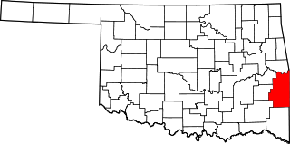
This is a list of the National Register of Historic Places listings in Le Flore County, Oklahoma.

National Register of Historic Places listings in Logan County, Oklahoma

This is a list of the National Register of Historic Places listings in Logan County, Oklahoma.

National Register of Historic Places listings in McCurtain County, Oklahoma

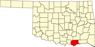
This is a list of the National Register of Historic Places listings in McCurtain County, Oklahoma.

National Register of Historic Places listings in McIntosh County, Oklahoma

This is a list of the National Register of Historic Places listings in McIntosh County, Oklahoma.

National Register of Historic Places listings in Murray County, Oklahoma

This is a list of the National Register of Historic Places listings in Murray County, Oklahoma.

National Register of Historic Places listings in Noble County, Oklahoma

This is a list of the National Register of Historic Places listings in Noble County, Oklahoma.

National Register of Historic Places listings in Okfuskee County, Oklahoma

This is a list of the National Register of Historic Places listings in Okfuskee County, Oklahoma.

National Register of Historic Places listings in Okmulgee County, Oklahoma

This is a list of the National Register of Historic Places listings in Okmulgee County, Oklahoma.

National Register of Historic Places listings in Pawnee County, Oklahoma

This is a list of the National Register of Historic Places listings in Pawnee County, Oklahoma.

National Register of Historic Places listings in Payne County, Oklahoma Wikimedia list article

This is a list of the National Register of Historic Places listings in Payne County, Oklahoma.

National Register of Historic Places listings in Tillman County, Oklahoma

This is a list of the National Register of Historic Places listings in Tillman County, Oklahoma.

National Register of Historic Places listings in Wagoner County, Oklahoma

This is a list of the National Register of Historic Places listings in Wagoner County, Oklahoma.

References

  1. The latitude and longitude information provided in this table was derived originally from the National Register Information System, which has been found to be fairly accurate for about 99% of listings. Some locations in this table may have been corrected to current GPS standards.
  2. National Park Service, United States Department of the Interior, "National Register of Historic Places: Weekly List Actions", retrieved June 24, 2022.
  3. Numbers represent an alphabetical ordering by significant words. Various colorings, defined here, differentiate National Historic Landmarks and historic districts from other NRHP buildings, structures, sites or objects.
  4. "National Register Information System". National Register of Historic Places . National Park Service. March 13, 2009.
  5. The eight-digit number below each date is the number assigned to each location in the National Register Information System database, which can be viewed by clicking the number.