National Register of Historic Places listings in Pontotoc County, Oklahoma

Last updated
Location of Pontotoc County in Oklahoma Map of Oklahoma highlighting Pontotoc County.svg
Location of Pontotoc County in Oklahoma

This is a list of the National Register of Historic Places listings in Pontotoc County, Oklahoma.

Contents

This is intended to be a complete list of the properties and districts on the National Register of Historic Places in Pontotoc County, Oklahoma, United States. The locations of National Register properties and districts for which the latitude and longitude coordinates are included below, may be seen in a map. [1]

National Register of Historic Places federal list of historic sites in the United States

The National Register of Historic Places (NRHP) is the United States federal government's official list of districts, sites, buildings, structures, and objects deemed worthy of preservation for their historical significance. A property listed in the National Register, or located within a National Register Historic District, may qualify for tax incentives derived from the total value of expenses incurred preserving the property.

Pontotoc County, Oklahoma County in the United States

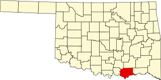
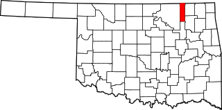
Pontotoc County is in the south central part of Oklahoma. As of the 2010 census, the population was 37,492. Its county seat is Ada. The county was created at statehood from part of the Chickasaw Nation in Indian Territory. It was named for a historic Chickasaw tribal area in Mississippi. According to the Encyclopedia of Oklahoma History and Culture, Pontotoc is usually translated "cattail prairie" or "land of hanging grapes."

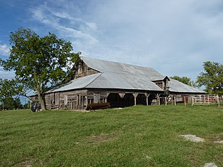
There are 9 properties and districts listed on the National Register in the county.

This National Park Service list is complete through NPS recent listings posted July 20, 2018. [2]
Map all coordinates using: OpenStreetMap  ·  Google Maps
Download coordinates as: KML  ·  GPX

Current listings

[3] Name on the Register [4] ImageDate listed [5] Location City or townDescription
1 Ada Public Library
Ada Public Library AdaArtsHeritage.jpg
Ada Public Library
November 13, 1989
(#89001950)
400 S. Rennie
34°46′16″N96°40′35″W / 34.771111°N 96.676389°W / 34.771111; -96.676389 (Ada Public Library)
Ada
2 Bebee Field Round House Upload image August 5, 1985
(#85001699)
State Highway 13
34°51′57″N96°49′23″W / 34.865833°N 96.823056°W / 34.865833; -96.823056 (Bebee Field Round House)
Ada
3 East Central State Normal School
East Central State Normal School *EastCentralUniv 11May2003 001 (2731005936).jpg
East Central State Normal School
December 23, 1986
(#86003470)
East Central University campus
34°46′28″N96°39′51″W / 34.774444°N 96.664167°W / 34.774444; -96.664167 (East Central State Normal School)
Ada
4 F.W. Meaders House Upload image April 4, 2007
(#07000258)
521 South Broadway
34°46′10″N96°40′44″W / 34.769444°N 96.678889°W / 34.769444; -96.678889 (F.W. Meaders House)
Ada
5 Mijo Camp Industrial District Upload image September 26, 1985
(#85002560)
Northern side of Pontotoc County Road 148
34°52′10″N96°48′30″W / 34.869444°N 96.808333°W / 34.869444; -96.808333 (Mijo Camp Industrial District)
Ada
6 Pontotoc County Courthouse
Pontotoc County Courthouse Pontotoc County Courthouse, Ada, Oklahoma 3.jpg
Pontotoc County Courthouse
August 24, 1984
(#84003418)
120 W. 13th St.
34°46′21″N96°40′46″W / 34.7726°N 96.6795°W / 34.7726; -96.6795 (Pontotoc County Courthouse)
Ada
7 Roff Armory
Roff Armory RoffArmoryOK2.JPG
Roff Armory
September 18, 1997
(#97001151)
Junction of Burns and N. 9th Sts.
34°37′41″N96°50′33″W / 34.628056°N 96.8425°W / 34.628056; -96.8425 (Roff Armory)
Roff
8 Sugg Clinic
Sugg Clinic Sugg Clinic, Ada, Oklahoma 2.jpg
Sugg Clinic
November 30, 1999
(#99001426)
100 E. 13th St.
34°46′20″N96°40′41″W / 34.772222°N 96.678056°W / 34.772222; -96.678056 (Sugg Clinic)
Ada
9 Wintersmith Park Historic District
Wintersmith Park Historic District WintersmithLake 07Aug2008.jpg
Wintersmith Park Historic District
June 2, 2000
(#00000623)
E. 18th St. and Scenic Dr.
34°45′38″N96°39′09″W / 34.760556°N 96.6525°W / 34.760556; -96.6525 (Wintersmith Park Historic District)
Ada

See also

National Register of Historic Places listings in Oklahoma Wikimedia list article

This is a list of properties and historic districts in Oklahoma that are designated on the National Register of Historic Places. Listings are distributed across all of Oklahoma's 77 counties.

Related Research Articles

National Register of Historic Places listings in Oklahoma County, Oklahoma Wikimedia list article

This is a list of the National Register of Historic Places listings in Oklahoma County, Oklahoma.

National Register of Historic Places listings in Bryan County, Oklahoma Wikimedia list article

This is a list of the National Register of Historic Places listings in Bryan County, Oklahoma.

National Register of Historic Places listings in Cherokee County, Oklahoma Wikimedia list article

This is a list of the National Register of Historic Places listings in Cherokee County, Oklahoma.

National Register of Historic Places listings in Cimarron County, Oklahoma Wikimedia list article

This is a list of the National Register of Historic Places listings in Cimarron County, Oklahoma.

National Register of Historic Places listings in Cleveland County, Oklahoma Wikimedia list article

This is a list of the National Register of Historic Places listings in Cleveland County, Oklahoma.

National Register of Historic Places listings in Comanche County, Oklahoma Wikimedia list article

This is a list of the National Register of Historic Places listings in Comanche County, Oklahoma.

National Register of Historic Places listings in Tulsa County, Oklahoma Wikimedia list article

This is a list of the National Register of Historic Places listings in Tulsa County, Oklahoma.

National Register of Historic Places listings in Muskogee County, Oklahoma Wikimedia list article

This is a list of the National Register of Historic Places listings in Muskogee County, Oklahoma.

National Register of Historic Places listings in Lincoln County, Oklahoma Wikimedia list article

This is a list of the National Register of Historic Places listings in Lincoln County, Oklahoma.

National Register of Historic Places listings in Kay County, Oklahoma Wikimedia list article

This is a list of the National Register of Historic Places listings in Kay County, Oklahoma.

National Register of Historic Places listings in Le Flore County, Oklahoma Wikimedia list article

This is a list of the National Register of Historic Places listings in Le Flore County, Oklahoma.

National Register of Historic Places listings in Pittsburg County, Oklahoma Wikimedia list article

This is a list of the National Register of Historic Places listings in Pittsburg County, Oklahoma.

National Register of Historic Places listings in Logan County, Oklahoma Wikimedia list article

This is a list of the National Register of Historic Places listings in Logan County, Oklahoma.

National Register of Historic Places listings in McCurtain County, Oklahoma Wikimedia list article

This is a list of the National Register of Historic Places listings in McCurtain County, Oklahoma.

National Register of Historic Places listings in Murray County, Oklahoma Wikimedia list article

This is a list of the National Register of Historic Places listings in Murray County, Oklahoma.

National Register of Historic Places listings in Okfuskee County, Oklahoma Wikimedia list article

This is a list of the National Register of Historic Places listings in Okfuskee County, Oklahoma.

National Register of Historic Places listings in Okmulgee County, Oklahoma Wikimedia list article

This is a list of the National Register of Historic Places listings in Okmulgee County, Oklahoma.

National Register of Historic Places listings in Roger Mills County, Oklahoma Wikimedia list article

This is a list of the National Register of Historic Places listings in Roger Mills County, Oklahoma.

National Register of Historic Places listings in Washington County, Oklahoma Wikimedia list article

This is a list of the National Register of Historic Places listings in Washington County, Oklahoma.

National Register of Historic Places listings in Washita County, Oklahoma Wikimedia list article

This is a list of the National Register of Historic Places listings in Washita County, Oklahoma.

References

  1. The latitude and longitude information provided in this table was derived originally from the National Register Information System, which has been found to be fairly accurate for about 99% of listings. For about 1% of NRIS original coordinates, experience has shown that one or both coordinates are typos or otherwise extremely far off; some corrections may have been made. A more subtle problem causes many locations to be off by up to 150 yards, depending on location in the country: most NRIS coordinates were derived from tracing out latitude and longitudes from USGS topographical quadrant maps created under the North American Datum of 1927 , which differs from the current, highly accurate WGS84 GPS system used by most on-line maps. Chicago is about right, but NRIS longitudes in Washington are higher by about 4.5 seconds, and are lower by about 2.0 seconds in Maine. Latitudes differ by about 1.0 second in Florida. Some locations in this table may have been corrected to current GPS standards.
  2. "National Register of Historic Places: Weekly List Actions". National Park Service, United States Department of the Interior. Retrieved on July 20, 2018.
  3. Numbers represent an ordering by significant words. Various colorings, defined here, differentiate National Historic Landmarks and historic districts from other NRHP buildings, structures, sites or objects.
  4. National Park Service (2009-03-13). "National Register Information System". National Register of Historic Places . National Park Service.
  5. The eight-digit number below each date is the number assigned to each location in the National Register Information System database, which can be viewed by clicking the number.