National Register of Historic Places listings in Rogers County, Oklahoma

Last updated

Location of Rogers County in Oklahoma Map of Oklahoma highlighting Rogers County.svg
Location of Rogers County in Oklahoma

This is a list of the National Register of Historic Places listings in Rogers County, Oklahoma.

Contents

This is intended to be a complete list of the properties and districts on the National Register of Historic Places in Rogers County, Oklahoma, United States. The locations of National Register properties and districts for which the latitude and longitude coordinates are included below, may be seen in a map. [1]

There are 19 properties and districts listed on the National Register in the county.


    This National Park Service list is complete through NPS recent listings posted November 10, 2023. [2]

Map all coordinates using: OpenStreetMap

Current listings

[3] Name on the Register [4] ImageDate listed [5] Location City or townDescription
1 I.W.W. Beck Building
I.W.W. Beck Building I.W.W. Beck Building, Oologah, OK.jpg
I.W.W. Beck Building
September 10, 1999
(#99001086)
146 W. Cooweescoowee Ave.
36°26′50″N95°42′31″W / 36.447222°N 95.708611°W / 36.447222; -95.708611 (I.W.W. Beck Building)
Oologah
2 The Belvidere
The Belvidere The Belvidere Mansion.jpg
The Belvidere
March 24, 1982
(#82003696)
109 N. Chickasaw Ave.
36°18′39″N95°36′37″W / 36.310833°N 95.610278°W / 36.310833; -95.610278 (The Belvidere)
Claremore
3 Chelsea Motel
Chelsea Motel Chelsea Motel.jpg
Chelsea Motel
May 27, 2004
(#04000525)
Junction of 1st and State Highway 66
36°32′15″N95°25′33″W / 36.5375°N 95.425833°W / 36.5375; -95.425833 (Chelsea Motel)
Chelsea
4 Claremore Auto Dealership February 23, 1995
(#95000042)
625 W. Will Rogers Boulevard
36°18′46″N95°37′02″W / 36.312778°N 95.617222°W / 36.312778; -95.617222 (Claremore Auto Dealership)
Claremore
5 Downtown Claremore Historic District
Downtown Claremore Historic District Downtownclaremore2.jpg
Downtown Claremore Historic District
September 12, 2016
(#16000623)
W. Will Rogers Blvd. bounded by Rt. 66, Muskogee Ave., 4th St. & alley between W. Will Rogers Blvd. & 2nd St.
36°18′43″N95°36′53″W / 36.312013°N 95.614759°W / 36.312013; -95.614759 (Downtown Claremore Historic District)
Claremore
6 Eastern University Preparatory School
Eastern University Preparatory School Rogersstate-strattontaylorlibrary.JPG
Eastern University Preparatory School
February 19, 1982
(#82003697)
College Hill
36°19′12″N95°38′07″W / 36.32°N 95.635278°W / 36.32; -95.635278 (Eastern University Preparatory School)
Claremore
7 Foyil Filling Station
Foyil Filling Station Foyil Filling Station.png
Foyil Filling Station
December 8, 2015
(#15000875)
12243 S. Andy Payne Blvd.
36°26′03″N95°31′12″W / 36.434281°N 95.519874°W / 36.434281; -95.519874 (Foyil Filling Station)
Foyil
8 Ed Galloway's Totem Pole Park
Ed Galloway's Totem Pole Park Totem Pole Park.jpg
Ed Galloway's Totem Pole Park
March 30, 1999
(#99000354)
State Highway 28A, 3.5 miles east of the former U.S. Route 66
36°26′14″N95°26′53″W / 36.437222°N 95.448056°W / 36.437222; -95.448056 (Ed Galloway's Totem Pole Park)
Foyil
9 Hanes Home
Hanes Home Hanes Home.PNG
Hanes Home
July 12, 1982
(#82003700)
Off State Highway 88
36°20′04″N95°39′06″W / 36.334444°N 95.651667°W / 36.334444; -95.651667 (Hanes Home)
Sageeyah
10 Hogue House
Hogue House Hogue House.jpg
Hogue House
December 17, 1982
(#82001498)
1001 S. Olive St.
36°31′52″N95°26′03″W / 36.531111°N 95.434167°W / 36.531111; -95.434167 (Hogue House)
Chelsea
11 Mendenhall's Bath House March 23, 1983
(#83002127)
601 E. 7th St.
36°18′39″N95°36′02″W / 36.310833°N 95.600556°W / 36.310833; -95.600556 (Mendenhall's Bath House)
Claremore
12 Maurice Meyer Barracks
Maurice Meyer Barracks Maurice Meyer Barracks, Claremore, OK.jpg
Maurice Meyer Barracks
March 1, 1982
(#82003698)
College Hill
36°19′08″N95°38′07″W / 36.318889°N 95.635278°W / 36.318889; -95.635278 (Maurice Meyer Barracks)
Claremore
13 Oologah Bank
Oologah Bank 20150824-bank of Oologah-2.jpg
Oologah Bank
May 10, 1982
(#82003699)
105 S. Maple St.
36°26′48″N95°42′35″W / 36.446667°N 95.709722°W / 36.446667; -95.709722 (Oologah Bank)
Oologah
14 Oologah Pump
Oologah Pump Oologah Pump.jpg
Oologah Pump
December 17, 1982
(#82001499)
Maple and Cooweescoowee Sts.
36°26′48″N95°42′35″W / 36.446667°N 95.709722°W / 36.446667; -95.709722 (Oologah Pump)
Oologah
15 Pryor Creek Bridge
Pryor Creek Bridge Pryor Creek Bridge.jpg
Pryor Creek Bridge
September 6, 2006
(#06000796)
Carries 1st St. over Pryor Creek, southwest of its junction with State Highway 66
36°32′18″N95°24′54″W / 36.538333°N 95.415°W / 36.538333; -95.415 (Pryor Creek Bridge)
Chelsea
16 Will Rogers Birthplace
Will Rogers Birthplace DogIronRanchHouse.jpg
Will Rogers Birthplace
September 29, 1970
(#70000538)
About 4 miles northeast of Oologah
36°28′10″N95°39′26″W / 36.469444°N 95.657222°W / 36.469444; -95.657222 (Will Rogers Birthplace)
Oologah
17 Will Rogers Hotel
Will Rogers Hotel Will Rogers Hotel.jpg
Will Rogers Hotel
December 29, 1994
(#94001508)
524 W. Will Rogers Boulevard
36°18′45″N95°36′55″W / 36.3125°N 95.615278°W / 36.3125; -95.615278 (Will Rogers Hotel)
Claremore
18 Will Rogers Memorial Library November 3, 2023
(#100009400)
121 North Weenonah Ave.
36°18′41″N95°36′40″W / 36.3115°N 95.6112°W / 36.3115; -95.6112 (Will Rogers Memorial Library)
Claremore
19 Verdigris Club Lodge
Verdigris Club Lodge Skelly Lodge.png
Verdigris Club Lodge
September 2, 2003
(#03000876)
27795 S. Skelly Dr.
36°12′43″N95°37′44″W / 36.211944°N 95.628889°W / 36.211944; -95.628889 (Verdigris Club Lodge)
Catoosa

See also

Related Research Articles

<span class="mw-page-title-main">National Register of Historic Places listings in Atoka County, Oklahoma</span>

This is a list of the National Register of Historic Places listings in Atoka County, Oklahoma.

<span class="mw-page-title-main">National Register of Historic Places listings in Beckham County, Oklahoma</span>

This is a list of the National Register of Historic Places listings in Beckham County, Oklahoma.

<span class="mw-page-title-main">National Register of Historic Places listings in Bryan County, Oklahoma</span>

This is a list of the National Register of Historic Places listings in Bryan County, Oklahoma.

<span class="mw-page-title-main">National Register of Historic Places listings in Canadian County, Oklahoma</span>

This is a list of the National Register of Historic Places listings in Canadian County, Oklahoma.

<span class="mw-page-title-main">National Register of Historic Places listings in Cimarron County, Oklahoma</span>

This is a list of the National Register of Historic Places listings in Cimarron County, Oklahoma.

<span class="mw-page-title-main">National Register of Historic Places listings in Coal County, Oklahoma</span>

This is a list of the National Register of Historic Places listings in Coal County, Oklahoma.

<span class="mw-page-title-main">National Register of Historic Places listings in Muskogee County, Oklahoma</span>

This is a list of the National Register of Historic Places listings in Muskogee County, Oklahoma.

<span class="mw-page-title-main">National Register of Historic Places listings in Custer County, Oklahoma</span>

This is a list of the National Register of Historic Places listings in Custer County, Oklahoma.

<span class="mw-page-title-main">National Register of Historic Places listings in Harmon County, Oklahoma</span>

This is a list of the National Register of Historic Places listings in Harmon County, Oklahoma.

<span class="mw-page-title-main">National Register of Historic Places listings in Kay County, Oklahoma</span>

This is a list of the National Register of Historic Places listings in Kay County, Oklahoma.

<span class="mw-page-title-main">National Register of Historic Places listings in LeFlore County, Oklahoma</span>

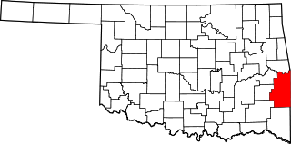
This is a list of the National Register of Historic Places listings in LeFlore County, Oklahoma.

<span class="mw-page-title-main">National Register of Historic Places listings in Pittsburg County, Oklahoma</span>

This is a list of the National Register of Historic Places listings in Pittsburg County, Oklahoma.

<span class="mw-page-title-main">National Register of Historic Places listings in Kiowa County, Oklahoma</span>

This is a list of the National Register of Historic Places listings in Kiowa County, Oklahoma.

<span class="mw-page-title-main">National Register of Historic Places listings in Logan County, Oklahoma</span>

This is a list of the National Register of Historic Places listings in Logan County, Oklahoma.

<span class="mw-page-title-main">National Register of Historic Places listings in McCurtain County, Oklahoma</span>

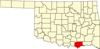
This is a list of the National Register of Historic Places listings in McCurtain County, Oklahoma.

<span class="mw-page-title-main">National Register of Historic Places listings in Okfuskee County, Oklahoma</span>

This is a list of the National Register of Historic Places listings in Okfuskee County, Oklahoma.

<span class="mw-page-title-main">National Register of Historic Places listings in Ottawa County, Oklahoma</span>

This is a list of the National Register of Historic Places listings in Ottawa County, Oklahoma.

<span class="mw-page-title-main">National Register of Historic Places listings in Payne County, Oklahoma</span>

This is a list of the National Register of Historic Places listings in Payne County, Oklahoma.

<span class="mw-page-title-main">National Register of Historic Places listings in Tillman County, Oklahoma</span>

This is a list of the National Register of Historic Places listings in Tillman County, Oklahoma.

<span class="mw-page-title-main">National Register of Historic Places listings in Wagoner County, Oklahoma</span>

This is a list of the National Register of Historic Places listings in Wagoner County, Oklahoma.

References

  1. The latitude and longitude information provided in this table was derived originally from the National Register Information System, which has been found to be fairly accurate for about 99% of listings. Some locations in this table may have been corrected to current GPS standards.
  2. National Park Service, United States Department of the Interior, "National Register of Historic Places: Weekly List Actions", retrieved November 10, 2023.
  3. Numbers represent an alphabetical ordering by significant words. Various colorings, defined here, differentiate National Historic Landmarks and historic districts from other NRHP buildings, structures, sites or objects.
  4. "National Register Information System". National Register of Historic Places . National Park Service. March 13, 2009.
  5. The eight-digit number below each date is the number assigned to each location in the National Register Information System database, which can be viewed by clicking the number.