National Register of Historic Places listings in Prince Edward County, Virginia

Last updated
Location of Prince Edward County in Virginia Map of Virginia highlighting Prince Edward County.svg
Location of Prince Edward County in Virginia

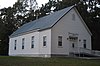
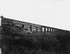
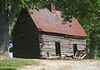
This is a list of the National Register of Historic Places listings in Prince Edward County, Virginia.

Contents

This is intended to be a complete list of the properties and districts on the National Register of Historic Places in Prince Edward County, Virginia, United States. The locations of National Register properties and districts for which the latitude and longitude coordinates are included below, may be seen in a Google map. [1]

National Register of Historic Places federal list of historic sites in the United States

The National Register of Historic Places (NRHP) is the United States federal government's official list of districts, sites, buildings, structures, and objects deemed worthy of preservation for their historical significance. A property listed in the National Register, or located within a National Register Historic District, may qualify for tax incentives derived from the total value of expenses incurred preserving the property.

Prince Edward County, Virginia County in the United States

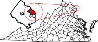
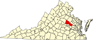
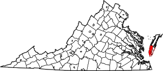
Prince Edward County is a county located in the Commonwealth of Virginia. As of the 2010 census, the population was 23,368. Its county seat is Farmville.

Virginia State of the United States of America

Virginia, officially the Commonwealth of Virginia, is a state in the Southeastern and Mid-Atlantic regions of the United States located between the Atlantic Coast and the Appalachian Mountains. Virginia is nicknamed the "Old Dominion" due to its status as the first English colonial possession established in mainland North America and "Mother of Presidents" because eight U.S. presidents were born there, more than any other state. The geography and climate of the Commonwealth are shaped by the Blue Ridge Mountains and the Chesapeake Bay, which provide habitat for much of its flora and fauna. The capital of the Commonwealth is Richmond; Virginia Beach is the most populous city, and Fairfax County is the most populous political subdivision. The Commonwealth's estimated population as of 2018 is over 8.5 million.

There are 15 properties and districts listed on the National Register in the county, including 2 National Historic Landmarks.

National Historic Landmark formal designation assigned by the United States federal government to historic buildings and sites in the United States

A National Historic Landmark (NHL) is a building, district, object, site, or structure that is officially recognized by the United States government for its outstanding historical significance. Of over 90,000 places listed on the country's National Register of Historic Places, only some 2,500 are recognized as National Historic Landmarks.

This National Park Service list is complete through NPS recent listings posted April 12, 2019. [2]
Map all coordinates using: OpenStreetMap  
Download coordinates as: KML  ·  GPX

Current listings

[3] Name on the Register [4] ImageDate listed [5] Location City or townDescription
1 Briery Church
Briery Church Briery Church Prince Edward County Virginia by Frances Benjamin Johnston.jpg
Briery Church
November 29, 1969
(#69000371)
Northwest of the junction of U.S. Route 15 and Briery Rd.
37°05′23″N78°28′44″W / 37.089722°N 78.478889°W / 37.089722; -78.478889 (Briery Church)
Briery
2 Buffalo Presbyterian Church
Buffalo Presbyterian Church Buffalo PCUSA, Prince Edward County.jpg
Buffalo Presbyterian Church
April 7, 1995
(#95000395)
Buffalo Church Rd., 0.3 miles (0.48 km) south of its junction with Five Forks Rd.
37°14′27″N78°36′02″W / 37.240833°N 78.600556°W / 37.240833; -78.600556 (Buffalo Presbyterian Church)
Pamplin
3 Debtor's Prison
Debtor's Prison Worsham debtors prison, exterior oblique.jpg
Debtor's Prison
September 22, 1972
(#72001412)
U.S. Route 15
37°13′41″N78°26′34″W / 37.228111°N 78.442694°W / 37.228111; -78.442694 (Debtor's Prison)
Worsham
4 Falkland
Falkland Falkland house near Meherrin.jpg
Falkland
June 22, 1979
(#79003071)
Northwest of Meherrin on Falkland Rd.
37°07′52″N78°24′30″W / 37.131111°N 78.408333°W / 37.131111; -78.408333 (Falkland)
Redd Shop
5 Farmville Historic District
Farmville Historic District HBT Farmville Train Station (5754493651).jpg
Farmville Historic District
October 30, 1989
(#89001822)
Roughly bounded by Main, Venable, High, Ely, and School Sts., 1st Ave., Irving St., 2nd Ave., Oak, W. 3rd, and Mill Sts.
37°18′06″N78°23′48″W / 37.301667°N 78.396667°W / 37.301667; -78.396667 (Farmville Historic District)
Farmville
6 First Baptist Church
First Baptist Church Farmville First Baptist Church.jpg
First Baptist Church
February 27, 2013
(#13000046)
100 S. Main St.
37°18′03″N78°23′35″W / 37.300833°N 78.393056°W / 37.300833; -78.393056 (First Baptist Church)
Farmville
7 Hampden-Sydney College Historic District
Hampden-Sydney College Historic District Cushing Hall at Hampden-Sydney College in Virginia.JPG
Hampden-Sydney College Historic District
February 26, 1970
(#70000822)
Bounded approximately by the Hampden-Sydney College campus
37°14′34″N78°27′32″W / 37.242639°N 78.458889°W / 37.242639; -78.458889 (Hampden-Sydney College Historic District)
Hampden-Sydney
8 High Bridge
High Bridge High Bridge Farmville Virginia.jpg
High Bridge
September 12, 2008
(#08000875)
Appomattox River
37°18′43″N78°19′10″W / 37.311944°N 78.319444°W / 37.311944; -78.319444 (High Bridge)
Farmville Extends into Cumberland County
9 Longwood House
Longwood House Longwood House, Farmville.jpg
Longwood House
March 8, 1984
(#84003564)
Johnson Dr.
37°17′30″N78°22′46″W / 37.291528°N 78.379583°W / 37.291528; -78.379583 (Longwood House)
Farmville
10 Robert Russa Moton Boyhood Home
Robert Russa Moton Boyhood Home Pleasant Shade-Moton birthpl 1757.jpg
Robert Russa Moton Boyhood Home
April 11, 2014
(#14000149)
4162 Lockett Rd., about 10 miles (16 km) from Rice
37°19′26″N78°16′10″W / 37.323806°N 78.269306°W / 37.323806; -78.269306 (Robert Russa Moton Boyhood Home)
Rice
11 Robert Russa Moton High School
Robert Russa Moton High School Robert Russa Moton High School, Farmville, VA.JPG
Robert Russa Moton High School
October 24, 1995
(#95001177)
Junction of S. Main St. and Griffin Boulevard
37°17′29″N78°23′52″W / 37.291389°N 78.397778°W / 37.291389; -78.397778 (Robert Russa Moton High School)
Farmville
12 Old Prince Edward County Clerk's Office
Old Prince Edward County Clerk's Office Old Worsham county clerks office.jpg
Old Prince Edward County Clerk's Office
September 10, 1979
(#79003072)
U.S. Route 15
37°13′44″N78°26′32″W / 37.228889°N 78.442222°W / 37.228889; -78.442222 (Old Prince Edward County Clerk's Office)
Worsham
13 Sayler's Creek Battlefield
Sayler's Creek Battlefield Sayler'sCreekBattlefield 1936 LookingAcrossSaylersCreek cropped.jpg
Sayler's Creek Battlefield
February 4, 1985
(#85002436)
Sayler's Creek, James Town, and Bunker Hill Rds.
37°19′55″N78°14′48″W / 37.331944°N 78.246667°W / 37.331944; -78.246667 (Sayler's Creek Battlefield)
Farmville
14 Twin Lakes State Park
Twin Lakes State Park Twin Lakes State Parks Cedar Crest Conference Center (10029234324).jpg
Twin Lakes State Park
October 31, 2012
(#12000906)
788 Twin Lakes Rd.
37°10′26″N78°16′25″W / 37.173889°N 78.273611°W / 37.173889; -78.273611 (Twin Lakes State Park)
Green Bay
15 Worsham High School
Worsham High School Former Worsham High School at dusk.jpg
Worsham High School
June 24, 2010
(#10000384)
8832 Abilene Rd.
37°13′49″N78°26′47″W / 37.230278°N 78.446389°W / 37.230278; -78.446389 (Worsham High School)
Farmville

See also

National Register of Historic Places listings in Virginia Wikimedia list article

Buildings, sites, districts, and objects in Virginia listed on the National Register of Historic Places:

Related Research Articles

National Register of Historic Places listings in Accomack County, Virginia Wikimedia list article

This is a list of the National Register of Historic Places listings in Accomack County, Virginia.

National Register of Historic Places listings in Amherst County, Virginia Wikimedia list article

This is a list of the National Register of Historic Places listings in Amherst County, Virginia.

National Register of Historic Places listings in Arlington County, Virginia Wikimedia list article

This is a list of the National Register of Historic Places listings in Arlington County, Virginia.

National Register of Historic Places listings in Augusta County, Virginia Wikimedia list article

This is a list of the National Register of Historic Places listings in Augusta County, Virginia.

National Register of Historic Places listings in Caroline County, Virginia Wikimedia list article

This is a list of the National Register of Historic Places listings in Caroline County, Virginia.

National Register of Historic Places listings in Hopewell, Virginia Wikimedia list article

This is a list of the National Register of Historic Places listings in Hopewell, Virginia.

National Register of Historic Places listings in Prince George County, Virginia Wikimedia list article

This is a list of the National Register of Historic Places listings in Prince George County, Virginia.

National Register of Historic Places listings in Hanover County, Virginia Wikimedia list article

This is a list of the National Register of Historic Places listings in Hanover County, Virginia.

National Register of Historic Places listings in Pittsylvania County, Virginia Wikimedia list article

This is a list of the National Register of Historic Places listings in Pittsylvania County, Virginia.

National Register of Historic Places listings in Monongalia County, West Virginia Wikimedia list article

This is a list of the National Register of Historic Places listings in Monongalia County, West Virginia.

National Register of Historic Places listings in Fluvanna County, Virginia Wikimedia list article

This is a list of the National Register of Historic Places listings in Fluvanna County, Virginia.

National Register of Historic Places listings in Isle of Wight County, Virginia Wikimedia list article

This is a list of the National Register of Historic Places listings in Isle of Wight County, Virginia.

National Register of Historic Places listings in Williamsburg, Virginia Wikimedia list article

This is a list of the National Register of Historic Places listings in Williamsburg, Virginia.

National Register of Historic Places listings in Lancaster County, Virginia Wikimedia list article

This is a list of the National Register of Historic Places listings in Lancaster County, Virginia.

National Register of Historic Places listings in Madison County, Virginia Wikimedia list article

This is a list of the National Register of Historic Places listings in Madison County, Virginia.

National Register of Historic Places listings in Northampton County, Virginia Wikimedia list article

This is a list of the National Register of Historic Places listings in Northampton County, Virginia.

National Register of Historic Places listings in Portsmouth, Virginia Wikimedia list article

This is a list of the National Register of Historic Places listings in Portsmouth, Virginia.

National Register of Historic Places listings in Richmond County, Virginia Wikimedia list article

This is a list of the National Register of Historic Places listings in Richmond County, Virginia.

National Register of Historic Places listings in Hampshire County, West Virginia Wikimedia list article

This is a list of the National Register of Historic Places listings in Hampshire County, West Virginia.

National Register of Historic Places listings in Braxton County, West Virginia Wikimedia list article

This is a list of the National Register of Historic Places listings in Braxton County, West Virginia.

References

  1. The latitude and longitude information provided in this table was derived originally from the National Register Information System, which has been found to be fairly accurate for about 99% of listings. For about 1% of NRIS original coordinates, experience has shown that one or both coordinates are typos or otherwise extremely far off; some corrections may have been made. A more subtle problem causes many locations to be off by up to 150 yards, depending on location in the country: most NRIS coordinates were derived from tracing out latitude and longitudes from USGS topographical quadrant maps created under the North American Datum of 1927 , which differs from the current, highly accurate WGS84 GPS system used by most on-line maps. Chicago is about right, but NRIS longitudes in Washington are higher by about 4.5 seconds, and are lower by about 2.0 seconds in Maine. Latitudes differ by about 1.0 second in Florida. Some locations in this table may have been corrected to current GPS standards.
  2. "National Register of Historic Places: Weekly List Actions". National Park Service, United States Department of the Interior. Retrieved on April 12, 2019.
  3. Numbers represent an ordering by significant words. Various colorings, defined here, differentiate National Historic Landmarks and historic districts from other NRHP buildings, structures, sites or objects.
  4. National Park Service (2008-04-24). "National Register Information System". National Register of Historic Places . National Park Service.
  5. The eight-digit number below each date is the number assigned to each location in the National Register Information System database, which can be viewed by clicking the number.