National Register of Historic Places listings in Surry County, Virginia

Last updated

Location of Surry County in Virginia Map of Virginia highlighting Surry County.svg
Location of Surry County in Virginia

This is a list of the National Register of Historic Places listings in Surry County, Virginia.

Contents

This is intended to be a complete list of the properties and districts on the National Register of Historic Places in Surry County, Virginia, United States. The locations of National Register properties and districts for which the latitude and longitude coordinates are included below, may be seen in an online map. [1]

There are 20 properties and districts listed on the National Register in the county, including 1 National Historic Landmark.


    This National Park Service list is complete through NPS recent listings posted March 18, 2022. [2]

Map all coordinates using: OpenStreetMap  
Download coordinates as: KML

Current listings

[3] Name on the Register [4] ImageDate listed [5] Location City or townDescription
1 Bacon's Castle
Bacon's Castle Bacon's Castle south front.jpg
Bacon's Castle
October 15, 1966
(#66000849)
Bacons Castle Trail
37°06′33″N76°43′20″W / 37.109028°N 76.722222°W / 37.109028; -76.722222 (Bacon's Castle)
Bacon's Castle
2 Cedar Ridge
Cedar Ridge Gate at the entrance to Cedar Ridge, night.jpg
Cedar Ridge
August 2, 2000
(#00000894)
4861 Laurel Dr.
37°06′38″N77°07′27″W / 37.110694°N 77.124028°W / 37.110694; -77.124028 (Cedar Ridge)
Disputanta
3 Chippokes Plantation
Chippokes Plantation Beautiful grounds at Chippokes (5822942656) (2).jpg
Chippokes Plantation
October 1, 1969
(#69000283)
Chippokes Farm Rd. in Chippokes State Park
37°08′19″N76°43′15″W / 37.138611°N 76.720833°W / 37.138611; -76.720833 (Chippokes Plantation)
Jamestown
4 Enos House
Enos House Enos House, oblique view with double chimney.jpg
Enos House
December 7, 1977
(#77001494)
Enos Farm Dr.
37°07′41″N76°50′56″W / 37.128056°N 76.848889°W / 37.128056; -76.848889 (Enos House)
Surry
5 Four Mile Tree
Four Mile Tree Fmt main house.jpg
Four Mile Tree
December 18, 1970
(#70000826)
Northeast of the junction of Southwark and Swanns Point Rds.
37°12′21″N76°51′11″W / 37.205833°N 76.853056°W / 37.205833; -76.853056 (Four Mile Tree)
Surry
6 Glebe House of Southwark Parish
Glebe House of Southwark Parish GLEBE HOUSE OF SOUTHWARK PARISH.jpg
Glebe House of Southwark Parish
May 17, 1976
(#76002123)
East of Spring Grove on State Route 10
37°08′26″N76°54′19″W / 37.140556°N 76.905278°W / 37.140556; -76.905278 (Glebe House of Southwark Parish)
Spring Grove
7 Melville
Melville Melville (Surry, Virginia).JPG
Melville
May 6, 1980
(#80004228)
Melville Dr.
37°08′33″N76°47′21″W / 37.142500°N 76.789167°W / 37.142500; -76.789167 (Melville)
Surry
8 Montpelier
Montpelier Montpelier House Surry.jpg
Montpelier
March 26, 1980
(#80004227)
1.4 miles (2.3 km) southwest of Cabin Point
37°10′20″N77°03′08″W / 37.172361°N 77.052361°W / 37.172361; -77.052361 (Montpelier)
Cabin Point
9 Old Brick Church
Old Brick Church Old Brick Church (Bacon's Castle, Virginia) 2014.JPG
Old Brick Church
January 2, 1986
(#86000002)
State Route 10
37°06′31″N76°44′08″W / 37.108611°N 76.735556°W / 37.108611; -76.735556 (Old Brick Church)
Bacon's Castle
10 Pleasant Point
Pleasant Point Point Pleasant, Surry County Courthouse vicinity, Surry vicinity (Surry County, Virginia).jpg
Pleasant Point
July 16, 1976
(#76002122)
1 mile south of Scotland on Pleasant Point Rd.
37°10′26″N76°46′32″W / 37.173889°N 76.775417°W / 37.173889; -76.775417 (Pleasant Point)
Scotland
11 Rich Neck Farm
Rich Neck Farm Rich Neck Farm building and combine.jpg
Rich Neck Farm
May 19, 1980
(#80004229)
East of Surry on Chippokes Farm Rd.
37°07′33″N76°45′05″W / 37.125833°N 76.751250°W / 37.125833; -76.751250 (Rich Neck Farm)
Surry
12 Rogers' Store
Rogers' Store Rogers and Gwaltney Stores.jpg
Rogers' Store
May 30, 2002
(#02000595)
Junction of Carsley and Otterdam Rds.
37°05′44″N77°00′20″W / 37.095556°N 77.005556°W / 37.095556; -77.005556 (Rogers' Store)
Surry
13 Second Southwark Church Archeological Site (44SY65)
Second Southwark Church Archeological Site (44SY65) Memorial on the site of the Southwark Church.jpg
Second Southwark Church Archeological Site (44SY65)
February 23, 1984
(#84003610)
Southwark Rd. [6]
37°11′08″N76°51′23″W / 37.185556°N 76.856389°W / 37.185556; -76.856389 (Second Southwark Church Archeological Site (44SY65))
Surry Site occupied by a 1927 monument [7]
14 Smith's Fort
Smith's Fort Smith's Fort Plantation house.JPG
Smith's Fort
June 15, 1970
(#70000827)
Smith Fort Ln.
37°09′50″N76°49′12″W / 37.1638°N 76.82°W / 37.1638; -76.82 (Smith's Fort)
Surry
15 Snow Hill
Snow Hill SNOW HILL, GWALTNEY CORNER, SURRY COUNTY, VA.jpg
Snow Hill
December 28, 1979
(#79003091)
State Route 40
37°05′20″N77°02′56″W / 37.088889°N 77.048889°W / 37.088889; -77.048889 (Snow Hill)
Gwaltney Corner
16 Surry County Courthouse Complex
Surry County Courthouse Complex Surry County Courthouse in Surry, April 2017.jpg
Surry County Courthouse Complex
April 10, 1986
(#86000719)
State Route 10
37°08′15″N76°50′05″W / 37.137500°N 76.834722°W / 37.137500; -76.834722 (Surry County Courthouse Complex)
Surry
17 Swann's Point Plantation Site
Swann's Point Plantation Site Swanns Point historic marker.jpg
Swann's Point Plantation Site
April 1, 1975
(#75002040)
North of Swanns Point Rd. [8]
37°12′00″N76°49′06″W / 37.200000°N 76.818333°W / 37.200000; -76.818333 (Swann's Point Plantation Site)
Scotland
18 Town of Surry Historic District
Town of Surry Historic District Confederate Statue, Surry, Virginia.jpg
Town of Surry Historic District
November 24, 2017
(#100001855)
Generally along E. Colonial Trail, the Rolfe Highway, Lebanon and Beechland Rds., and Bank, School, and Church Sts.
37°08′17″N76°50′03″W / 37.138056°N 76.834167°W / 37.138056; -76.834167 (Town of Surry Historic District)
Surry
19 Walnut Valley
Walnut Valley Walnut Valley farmstead with cotton field.jpg
Walnut Valley
August 27, 2013
(#13000649)
Southeastern corner of Highgate and Chippokes Farm Rds. [9] :51
37°07′14″N76°44′33″W / 37.120556°N 76.742500°W / 37.120556; -76.742500 (Walnut Valley)
Highgate Includes an archaeological site surrounding a rare surviving slave house [9] :18
20 Warren House
Warren House Smith's Fort Plantation.jpg
Warren House
November 14, 1973
(#73002065)
Northeast of Surry on Smith Fort Ln.
37°09′51″N76°49′12″W / 37.164167°N 76.820000°W / 37.164167; -76.820000 (Warren House)
Surry

See also

Related Research Articles

National Register of Historic Places listings in Alleghany County, Virginia

This is a list of the National Register of Historic Places listings in Alleghany County, Virginia.

National Register of Historic Places listings in Amelia County, Virginia

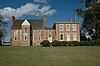
This is a list of the National Register of Historic Places listings in Amelia County, Virginia.

National Register of Historic Places listings in Bath County, Virginia

This is a list of the National Register of Historic Places listings in Bath County, Virginia.

National Register of Historic Places listings in Bedford County, Virginia

This is a list of the National Register of Historic Places listings in Bedford County, Virginia.

National Register of Historic Places listings in Carroll County, Virginia

This is a list of the National Register of Historic Places listings in Carroll County, Virginia.

National Register of Historic Places listings in Clarke County, Virginia

This is a list of the National Register of Historic Places listings in Clarke County, Virginia.

National Register of Historic Places listings in Essex County, Virginia

This is a list of the National Register of Historic Places listings in Essex County, Virginia.

National Register of Historic Places listings in Fauquier County, Virginia

This is a list of the National Register of Historic Places listings in Fauquier County, Virginia.

National Register of Historic Places listings in Goochland County, Virginia Wikimedia list article

This is a list of the National Register of Historic Places listings in Goochland County, Virginia.

National Register of Historic Places listings in Greene County, Virginia

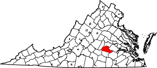
This is a list of the National Register of Historic Places listings in Greene County, Virginia.

National Register of Historic Places listings in Rockingham County, Virginia

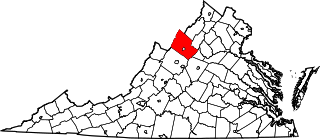
This is a list of the National Register of Historic Places listings in Rockingham County, Virginia.

National Register of Historic Places listings in Hardy County, West Virginia

This is a list of the National Register of Historic Places listings in Hardy County, West Virginia.

National Register of Historic Places listings in New Kent County, Virginia

This is a list of the National Register of Historic Places listings in New Kent County, Virginia.

National Register of Historic Places listings in Orange County, Virginia

This is a list of the National Register of Historic Places listings in Orange County, Virginia.

National Register of Historic Places listings in Shenandoah County, Virginia

This is a list of the National Register of Historic Places listings in Shenandoah County, Virginia.

National Register of Historic Places listings in Nottoway County, Virginia

This is a list of the National Register of Historic Places listings in Nottoway County, Virginia.

National Register of Historic Places listings in Surry County, North Carolina

This list includes properties and districts listed on the National Register of Historic Places in Surry County, North Carolina, United States. Click the "Map of all coordinates" link to the right to view an online map of all properties and districts with latitude and longitude coordinates in the table below.

National Register of Historic Places listings in Craig County, Virginia Wikimedia list article

This is a list of the National Register of Historic Places listings in Craig County, Virginia.

National Register of Historic Places listings in Giles County, Virginia

This is a list of the National Register of Historic Places listings in Giles County, Virginia.

National Register of Historic Places listings in Grayson County, Virginia Wikimedia list article

This is a list of the National Register of Historic Places listings in Grayson County, Virginia.

References

  1. The latitude and longitude information provided in this table was derived originally from the National Register Information System, which has been found to be fairly accurate for about 99% of listings. Some locations in this table may have been corrected to current GPS standards.
  2. National Park Service, United States Department of the Interior, "National Register of Historic Places: Weekly List Actions", retrieved March 18, 2022.
  3. Numbers represent an alphabetical ordering by significant words. Various colorings, defined here, differentiate National Historic Landmarks and historic districts from other NRHP buildings, structures, sites or objects.
  4. "National Register Information System". National Register of Historic Places . National Park Service. April 24, 2008.
  5. The eight-digit number below each date is the number assigned to each location in the National Register Information System database, which can be viewed by clicking the number.
  6. See church sign depicted at
  7. Loth, Calder. Virginia Landmarks Register. 4th ed. Charlottesville, Virginia: UP of Virginia, 1999, 519.
  8. "Swanns Point Plantation". Geographic Names Information System . United States Geological Survey.
  9. 1 2 Lewes, David. National Register of Historic Places Inventory/Nomination: Walnut Valley. National Park Service, 2013-03-15.