National Register of Historic Places listings in Wythe County, Virginia

Last updated

Location of Wythe County in Virginia Map of Virginia highlighting Wythe County.svg
Location of Wythe County in Virginia

This is a list of the National Register of Historic Places listings in Wythe County, Virginia.

Contents

This is intended to be a complete list of the properties and districts on the National Register of Historic Places in Wythe County, Virginia, United States. The locations of National Register properties and districts for which the latitude and longitude coordinates are included below, may be seen in an online map. [1]

There are 22 properties and districts listed on the National Register in the county.


    This National Park Service list is complete through NPS recent listings posted June 3, 2022. [2]

Map all coordinates using: OpenStreetMap  
Download coordinates as: KML

Current listings

[3] Name on the Register [4] ImageDate listed [5] Location City or townDescription
1 Cornett Archeological Site (44WY1)
Cornett Archeological Site (44WY1) Cornett Archeological Site.jpg
Cornett Archeological Site (44WY1)
September 29, 1983
(#83003320)
New River below Austinville [6] :202
36°51′32″N80°54′44″W / 36.858889°N 80.912222°W / 36.858889; -80.912222 (Cornett Archeological Site (44WY1))
Austinville
2 Crockett's Cove Presbyterian Church
Crockett's Cove Presbyterian Church Cove church.jpg
Crockett's Cove Presbyterian Church
October 15, 1992
(#92001373)
Crockett's Cove Rd., east of its junction with Smith Hollow Rd.
37°01′35″N81°02′14″W / 37.026250°N 81.037222°W / 37.026250; -81.037222 (Crockett's Cove Presbyterian Church)
Wytheville
3 Fort Chiswell Mansion
Fort Chiswell Mansion The Mansion at Fort Chiswell.JPG
Fort Chiswell Mansion
May 6, 1971
(#71000992)
325 Factory Outlet Drive; Interstate 81 near its junction with U.S. Route 52 and State Route 121
36°56′46″N80°56′12″W / 36.946111°N 80.936667°W / 36.946111; -80.936667 (Fort Chiswell Mansion)
Fort Chiswell
4 Fort Chiswell Site
Fort Chiswell Site FortChiswellVAMonument.jpg
Fort Chiswell Site
August 29, 1978
(#78003046)
E Lee Highway
36°56′54″N80°56′04″W / 36.948406°N 80.934319°W / 36.948406; -80.934319 (Fort Chiswell Site)
Fort Chiswell
5 Foster Falls Historic District
Foster Falls Historic District FOSTER FALLS HISTORIC DISTRICT.jpg
Foster Falls Historic District
November 12, 2009
(#09000925)
New River Trail State Park, 176 Orphanage Dr.
36°53′03″N80°51′19″W / 36.884167°N 80.855278°W / 36.884167; -80.855278 (Foster Falls Historic District)
Max Meadows
6 Andrew and Sarah Fulton Farm May 26, 2022
(#100007782)
531 Kohler Ave.
36°51′42″N80°54′17″W / 36.8618°N 80.9046°W / 36.8618; -80.9046 (Andrew and Sarah Fulton Farm)
Austinville vicinity
7 Graham's Forge Mill
Graham's Forge Mill Grahams Forge Mill.jpg
Graham's Forge Mill
May 26, 2005
(#05000481)
Major Graham Rd.
36°56′27″N80°53′12″W / 36.940833°N 80.886667°W / 36.940833; -80.886667 (Graham's Forge Mill)
Max Meadows
8 Maj. David Graham House
Maj. David Graham House M Grahams2.jpg
Maj. David Graham House
February 14, 1985
(#85000300)
Junction of Major Grahams and Carters Ferry Rds.
36°54′58″N80°52′18″W / 36.916111°N 80.871667°W / 36.916111; -80.871667 (Maj. David Graham House)
Fosters Falls
9 Haller-Gibboney Rock House
Haller-Gibboney Rock House HALLER-GIBONEY ROCK HOUSE.jpg
Haller-Gibboney Rock House
November 9, 1972
(#72001419)
Monroe and Tazewell Sts.
36°57′02″N81°05′04″W / 36.950556°N 81.084444°W / 36.950556; -81.084444 (Haller-Gibboney Rock House)
Wytheville
10 Kimberling Lutheran Cemetery
Kimberling Lutheran Cemetery K Church.jpg
Kimberling Lutheran Cemetery
March 26, 1980
(#80004231)
Northwest of Rural Retreat
36°55′05″N81°18′17″W / 36.918056°N 81.304722°W / 36.918056; -81.304722 (Kimberling Lutheran Cemetery)
Rural Retreat
11 Loretto
Loretto LORETTO, WYTHEVILLE, WYTHE COUNTY, VA.jpg
Loretto
September 8, 1994
(#94001093)
190 Peppers Ferry Rd.
36°57′27″N81°04′49″W / 36.95750°N 81.080278°W / 36.95750; -81.080278 (Loretto)
Wytheville
12 Martin Site
Martin Site Martin Site along the New River.jpg
Martin Site
August 13, 1974
(#74002152)
Bounded by Reed Creek Rd., the New River, and Reed Creek [6] :172
36°55′24″N80°49′33″W / 36.923333°N 80.825833°W / 36.923333; -80.825833 (Martin Site)
Fosters Falls
13 McGavock Family Cemetery
McGavock Family Cemetery McGavock Family Cemetery.jpg
McGavock Family Cemetery
June 22, 1979
(#79003098)
East of Fort Chiswell off Interstate 81
36°56′52″N80°55′29″W / 36.947778°N 80.924722°W / 36.947778; -80.924722 (McGavock Family Cemetery)
Fort Chiswell
14 Reed Creek Mill
Reed Creek Mill Reed Creek Mill in Wytheville, VA.jpg
Reed Creek Mill
November 22, 2016
(#16000802)
1565 S. Church St.
36°56′09″N81°04′28″W / 36.935833°N 81.074444°W / 36.935833; -81.074444 (Reed Creek Mill)
Wytheville
15 Rural Retreat Depot
Rural Retreat Depot RR Depot.jpg
Rural Retreat Depot
August 25, 2014
(#14000531)
105 Railroad Ave.
36°53′38″N81°16′35″W / 36.893889°N 81.276389°W / 36.893889; -81.276389 (Rural Retreat Depot)
Rural Retreat
16 Sanders Farm
Sanders Farm Sanders farm.jpg
Sanders Farm
May 22, 2003
(#03000454)
3908 Fort Chiswell Rd.
36°52′26″N80°52′16″W / 36.873750°N 80.871111°W / 36.873750; -80.871111 (Sanders Farm)
Max Meadows
17 Shot Tower
Shot Tower Shottower wytheco.jpg
Shot Tower
October 1, 1969
(#69000286)
West of the junction of U.S. Route 52 with Foster Falls Rd.
36°52′13″N80°52′13″W / 36.870194°N 80.870278°W / 36.870194; -80.870278 (Shot Tower)
Max Meadows
18 St. John's Episcopal Church
St. John's Episcopal Church St. John's Episcopal Church, Wytheville, Virginia.JPG
St. John's Episcopal Church
September 9, 2008
(#08000894)
275 E. Main St.
36°57′03″N81°04′55″W / 36.950833°N 81.081944°W / 36.950833; -81.081944 (St. John's Episcopal Church)
Wytheville
19 St. John's Lutheran Church and Cemetery
St. John's Lutheran Church and Cemetery ST. JOHN'S LUTHERAN CHURCH AND CEMETERY.jpg
St. John's Lutheran Church and Cemetery
January 26, 1978
(#78003047)
Northwest of Wytheville at the junction of U.S. Routes 21/52 with Interstate 81
36°57′42″N81°06′03″W / 36.961667°N 81.100833°W / 36.961667; -81.100833 (St. John's Lutheran Church and Cemetery)
Wytheville
20 Wythe County Poorhouse Farm
Wythe County Poorhouse Farm Wythe County Poorhouse Farm.jpg
Wythe County Poorhouse Farm
May 26, 2000
(#00000557)
Peppers Ferry Rd.
36°58′56″N81°01′42″W / 36.982222°N 81.028333°W / 36.982222; -81.028333 (Wythe County Poorhouse Farm)
Wytheville
21 Wytheville Historic District
Wytheville Historic District WytheCoCourthouse.jpg
Wytheville Historic District
September 30, 1994
(#94001179)
Roughly bounded by Monroe, 11th, Jefferson, and 12th Sts., and W. Railroad Ave.
36°56′50″N81°05′04″W / 36.947222°N 81.084444°W / 36.947222; -81.084444 (Wytheville Historic District)
Wytheville
22 Zion Evangelical Lutheran Church Cemetery
Zion Evangelical Lutheran Church Cemetery Zion Cemetery.jpg
Zion Evangelical Lutheran Church Cemetery
February 1, 1979
(#79003099)
Northwest of Speedwell
36°50′28″N81°13′21″W / 36.841111°N 81.2225°W / 36.841111; -81.2225 (Zion Evangelical Lutheran Church Cemetery)
Speedwell

See also

Related Research Articles

National Register of Historic Places listings in Alleghany County, Virginia

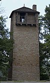
This is a list of the National Register of Historic Places listings in Alleghany County, Virginia.

National Register of Historic Places listings in Amelia County, Virginia

This is a list of the National Register of Historic Places listings in Amelia County, Virginia.

National Register of Historic Places listings in Bath County, Virginia

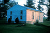
This is a list of the National Register of Historic Places listings in Bath County, Virginia.

National Register of Historic Places listings in Brunswick County, Virginia

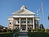
This is a list of the National Register of Historic Places listings in Brunswick County, Virginia.

National Register of Historic Places listings in Rockbridge County, Virginia

This is a list of the National Register of Historic Places listings in Rockbridge County, Virginia.

National Register of Historic Places listings in Clarke County, Virginia

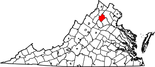
This is a list of the National Register of Historic Places listings in Clarke County, Virginia.

National Register of Historic Places listings in Essex County, Virginia

This is a list of the National Register of Historic Places listings in Essex County, Virginia.

National Register of Historic Places listings in Goochland County, Virginia Wikimedia list article

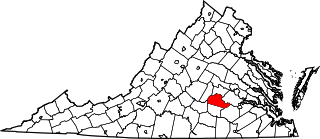
This is a list of the National Register of Historic Places listings in Goochland County, Virginia.

National Register of Historic Places listings in Greene County, Virginia

This is a list of the National Register of Historic Places listings in Greene County, Virginia.

National Register of Historic Places listings in Rockingham County, Virginia

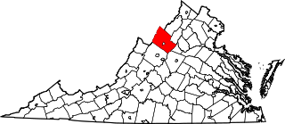
This is a list of the National Register of Historic Places listings in Rockingham County, Virginia.

National Register of Historic Places listings in Henry County, Virginia

This is a list of the National Register of Historic Places listings in Henry County, Virginia.

National Register of Historic Places listings in King William County, Virginia

This is a list of the National Register of Historic Places listings in King William County, Virginia.

National Register of Historic Places listings in Louisa County, Virginia

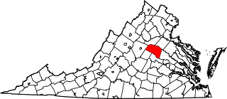
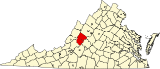
This is a list of the National Register of Historic Places listings in Louisa County, Virginia.

National Register of Historic Places listings in Orange County, Virginia

This is a list of the National Register of Historic Places listings in Orange County, Virginia.

National Register of Historic Places listings in Rappahannock County, Virginia

This is a list of the National Register of Historic Places listings in Rappahannock County, Virginia.

National Register of Historic Places listings in Shenandoah County, Virginia

This is a list of the National Register of Historic Places listings in Shenandoah County, Virginia.

National Register of Historic Places listings in Prince Edward County, Virginia

This is a list of the National Register of Historic Places listings in Prince Edward County, Virginia.

National Register of Historic Places listings in Pendleton County, West Virginia

This is a list of the National Register of Historic Places listings in Pendleton County, West Virginia.

National Register of Historic Places listings in Bland County, Virginia

This is a list of the National Register of Historic Places listings in Bland County, Virginia.

National Register of Historic Places listings in Grayson County, Virginia Wikimedia list article

This is a list of the National Register of Historic Places listings in Grayson County, Virginia.

References

  1. The latitude and longitude information provided in this table was derived originally from the National Register Information System, which has been found to be fairly accurate for about 99% of listings. Some locations in this table may have been corrected to current GPS standards.
  2. National Park Service, United States Department of the Interior, "National Register of Historic Places: Weekly List Actions", retrieved June 3, 2022.
  3. Numbers represent an alphabetical ordering by significant words. Various colorings, defined here, differentiate National Historic Landmarks and historic districts from other NRHP buildings, structures, sites or objects.
  4. "National Register Information System". National Register of Historic Places . National Park Service. April 24, 2008.
  5. The eight-digit number below each date is the number assigned to each location in the National Register Information System database, which can be viewed by clicking the number.
  6. 1 2 MacCord, Howard A. "The Martin Site (44WY13), Wythe County, Virginia". Quarterly bulletin of the Archeological Society of Virginia 53.4 (1998): 171-203.