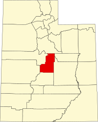
[3] Name on the Register [4] Image Date listed [5] Location City or town Description 1 Claus P. Andersen House Claus P. Andersen House February 1, 1983 (# 83003183 202 S. 200 East 39°21′22″N 111°34′56″W / 39.3561°N 111.5821°W / 39.3561; -111.5821 (Claus P. Andersen House ) Ephraim Adobe Scandinavian-style pair-house , one of oldest structures in Ephraim. 2 Lars S. Andersen House Lars S. Andersen House February 1, 1983 (# 83003184 213 N. 200 East 39°21′50″N 111°34′56″W / 39.3638°N 111.5821°W / 39.3638; -111.5821 (Lars S. Andersen House ) Ephraim Pair house with additions. 3 James Anderson House James Anderson House October 3, 1980 (# 80003945 15 S. 200 East 39°37′40″N 111°26′03″W / 39.6278°N 111.4342°W / 39.6278; -111.4342 (James Anderson House ) Fairview 4 Lewis and Clara Anderson House Lewis and Clara Anderson House January 12, 1998 (# 97001629 542 S. Main St. 39°15′27″N 111°38′15″W / 39.2575°N 111.6375°W / 39.2575; -111.6375 (Lewis and Clara Anderson House ) Manti Two-story brick Queen Anne . 5 Niels Ole Anderson House Niels Ole Anderson House October 5, 1978 (# 78002687 308 S. 100 East 39°21′15″N 111°35′04″W / 39.3543°N 111.5845°W / 39.3543; -111.5845 (Niels Ole Anderson House ) Ephraim Built in 1868 with Greek Revival and Federal stylings. 6 Ole Arilsen House Ole Arilsen House October 3, 1980 (# 80003953 89 N. 300 East 39°32′52″N 111°27′00″W / 39.5478°N 111.4501°W / 39.5478; -111.4501 (Ole Arilsen House ) Mount Pleasant Folk vernacular house of "2/3 central passageway plan" type, "with excellent brickwork". 7 Andrew Barentsen House Upload image February 1, 1983 (# 83003185 195 W. 200 South 39°37′28″N 111°38′22″W / 39.6244°N 111.6394°W / 39.6244; -111.6394 (Andrew Barentsen House ) Fountain Green Three-room pair house , possibly demolished sometime between 2007 & 2018. 8 Anthony W. Bessey House Anthony W. Bessey House October 22, 1980 (# 80003947 415 N. 300 West 39°16′18″N 111°38′34″W / 39.2716°N 111.6429°W / 39.2716; -111.6429 (Anthony W. Bessey House ) Manti Small stone house built around 1860, one of first outside Manti's forts. 9 Billings-Hougaard House Upload image October 14, 1980 (# 80003948 75 E. 300 North 39°16′12″N 111°38′07″W / 39.2700°N 111.6354°W / 39.2700; -111.6354 (Billings-Hougaard House ) Manti One of best surviving unsheathed adobe brick homes in Utah. 10 W.D. Candland House W.D. Candland House September 30, 2019 (# 100004482 123 N. 100 West 39°32′55″N 111°27′28″W / 39.5485°N 111.4577°W / 39.5485; -111.4577 (W.D. Candland House ) Mount Pleasant Two-story brick Victorian Eclectic house built in 1904. 11 Casino Theatre Casino Theatre September 22, 1989 (# 89001416 78 S. Main St. 39°09′15″N 111°49′04″W / 39.1542°N 111.8178°W / 39.1542; -111.8178 (Casino Theatre ) Gunnison 12 Centerfield School and Meetinghouse Centerfield School and Meetinghouse September 12, 2000 (# 00001068 140 S. Main St. 39°07′25″N 111°49′11″W / 39.1236°N 111.8197°W / 39.1236; -111.8197 (Centerfield School and Meetinghouse ) Centerfield Stone school and church from c. 1886-67. 13 Cox Family Big House Complex Upload image April 7, 2020 (# 100005176 98 N. 100 West 39°16′02″N 111°38′20″W / 39.2672°N 111.6389°W / 39.2672; -111.6389 (Cox Family Big House Complex ) Manti 14 Cox-Shoemaker-Parry House Cox-Shoemaker-Parry House August 4, 1982 (# 82004157 50 N. 100 West 39°15′59″N 111°38′19″W / 39.2664°N 111.6387°W / 39.2664; -111.6387 (Cox-Shoemaker-Parry House ) Manti Limestone house built in 1858 by Cox, where he lived with his three wives. Expanded by Parry in 1880. 15 Charles Crawforth Farmstead Charles Crawforth Farmstead February 19, 1980 (# 80003956 Southwest of Spring City, approximately 6700 Crawford Rd. 39°27′16″N 111°30′45″W / 39.4544°N 111.5125°W / 39.4544; -111.5125 (Charles Crawforth Farmstead ) Spring City 1884 stone house and outbuildings, relatively isolated 16 John Dorius, Jr., House John Dorius, Jr., House May 9, 1985 (# 85000964 46 W. 100 North 39°21′43″N 111°35′18″W / 39.3619°N 111.5882°W / 39.3619; -111.5882 (John Dorius, Jr., House ) Ephraim Brick Queen Anne house from 1897. 17 Ephraim Carnegie Library Ephraim Carnegie Library October 25, 1984 (# 84000149 30 S. Main St. 39°22′05″N 111°35′12″W / 39.3681°N 111.5867°W / 39.3681; -111.5867 (Ephraim Carnegie Library ) Ephraim 18 Ephraim Relief Society Granary Ephraim Relief Society Granary September 30, 2019 (# 100004481 86 N. Main St. 39°21′40″N 111°35′12″W / 39.3611°N 111.5868°W / 39.3611; -111.5868 (Ephraim Relief Society Granary ) Ephraim Two-story stone granary building right on Main St., recently home of "Granary Arts" 19 Ephraim Tithing Office—Bishop's Storehouse Upload image October 30, 2020 (# 85003671 64 N. Main 39°21′31″N 111°35′14″W / 39.3587°N 111.5872°W / 39.3587; -111.5872 (Ephraim Tithing Office—Bishop's Storehouse ) Ephraim 20 Ephraim United Order Cooperative Building Ephraim United Order Cooperative Building March 20, 1973 (# 73001862 Main and 1st North Sts. 39°21′41″N 111°35′09″W / 39.3614°N 111.5858°W / 39.3614; -111.5858 (Ephraim United Order Cooperative Building ) Ephraim 21 Fairview Amusement Hall Fairview Amusement Hall May 10, 2002 (# 02000507 75 S. State St. 39°37′38″N 111°26′18″W / 39.6272°N 111.4383°W / 39.6272; -111.4383 (Fairview Amusement Hall ) Fairview 22 Fairview City Hall Fairview City Hall April 9, 1986 (# 86000745 85 S. State St. 39°37′36″N 111°26′18″W / 39.626667°N 111.438333°W / 39.626667; -111.438333 (Fairview City Hall ) Fairview 23 Fairview Tithing Office/Bishop's Storehouse Fairview Tithing Office/Bishop's Storehouse January 25, 1985 (# 85000281 60 W. 100 South 39°37′36″N 111°26′23″W / 39.626667°N 111.439722°W / 39.626667; -111.439722 (Fairview Tithing Office/Bishop's Storehouse ) Fairview 24 Jabez Faux House and Barn Jabez Faux House and Barn November 7, 1976 (# 76001835 Approximately 74 N. State Route 132 39°31′35″N 111°35′24″W / 39.526389°N 111.59°W / 39.526389; -111.59 (Jabez Faux House and Barn ) Moroni Home of blacksmith and farmer immigrant from Yorkshire . 25 Fountain Green Hydroelectric Plant Historic District Fountain Green Hydroelectric Plant Historic District April 20, 1989 (# 89000277 Northwest of Fountain Green 39°38′13″N 111°39′03″W / 39.637083°N 111.650972°W / 39.637083; -111.650972 (Fountain Green Hydroelectric Plant Historic District ) Fountain Green Made up of two discontiguous pieces. The western piece, the earthen dam at Big Springs reservoir, was destroyed in 2017 to improve the fish hatchery. 26 Great Basin Research Station Historic District Great Basin Research Station Historic District June 28, 1996 (# 96000678 State Route 29 , approximately 8 miles (13 km) east of Ephraim in the Manti-La Sal National Forest 39°19′12″N 111°29′12″W / 39.319977°N 111.486644°W / 39.319977; -111.486644 (Great Basin Research Station Historic District ) Ephraim Experiment station set up to explore whether over-grazing caused floods downstream. 27 Greaves-Deakin House Greaves-Deakin House October 3, 1980 (# 80003942 118 S. Main St. 39°21′27″N 111°35′13″W / 39.3575°N 111.586944°W / 39.3575; -111.586944 (Greaves-Deakin House ) Ephraim 28 Hans A. Hansen House Hans A. Hansen House October 22, 1980 (# 80003943 75 W. 100 North 39°21′41″N 111°35′15″W / 39.361389°N 111.5875°W / 39.361389; -111.5875 (Hans A. Hansen House ) Ephraim 29 Peter Hansen House Peter Hansen House February 1, 1983 (# 83003187 247 S. 200 East 39°15′42″N 111°37′56″W / 39.261667°N 111.632222°W / 39.261667; -111.632222 (Peter Hansen House ) Manti 30 Niels P. Hjort House Niels P. Hjort House October 3, 1980 (# 80003946 26 S. State St. 39°37′40″N 111°26′20″W / 39.627778°N 111.438889°W / 39.627778; -111.438889 (Niels P. Hjort House ) Fairview 31 Frederick C. Jensen House Upload image April 19, 1982 (# 82004158 215 S. 100 West 39°32′37″N 111°27′25″W / 39.543678°N 111.457046°W / 39.543678; -111.457046 (Frederick C. Jensen House ) Mount Pleasant 1891 house of Danish immigrant, Victorian Eclectic in style. 32 Hans C. Jensen House Upload image February 1, 1983 (# 83003188 263 E. 100 South 39°21′29″N 111°34′49″W / 39.358188°N 111.580404°W / 39.358188; -111.580404 (Hans C. Jensen House ) Ephraim Pair house built around 1870, two rooms deep. 33 Rasmus Jensen House Rasmus Jensen House February 1, 1983 (# 83003189 97 E. 100 South 39°21′30″N 111°35′04″W / 39.358222°N 111.584507°W / 39.358222; -111.584507 (Rasmus Jensen House ) Ephraim Vernacular pair house built probably in the 1870s 34 Robert Johnson House Robert Johnson House October 14, 1980 (# 80003949 103 E. 300 North 39°16′13″N 111°38′02″W / 39.270278°N 111.633889°W / 39.270278; -111.633889 (Robert Johnson House ) Manti 35 Johnson-Nielson House Johnson-Nielson House July 26, 1982 (# 82004156 351 N. Main St. 39°22′00″N 111°35′12″W / 39.366667°N 111.586667°W / 39.366667; -111.586667 (Johnson-Nielson House ) Ephraim 36 Francis Marion Jolley House Francis Marion Jolley House October 14, 1980 (# 80003950 201 S. 200 E. 39°15′44″N 111°37′59″W / 39.262296°N 111.633051°W / 39.262296; -111.633051 (Francis Marion Jolley House ) Manti 1875 brick house of English immigrant, with four dormer windows above first-floor window-door-window-window arrangement. 37 Oluf Larsen House Oluf Larsen House February 1, 1983 (# 83003190 75 S. 100 West 39°21′31″N 111°35′21″W / 39.358509°N 111.589195°W / 39.358509; -111.589195 (Oluf Larsen House ) Ephraim Pair-house built in 1870. 38 Larsen-Noyes House Larsen-Noyes House December 1, 1978 (# 78002688 96 E. Center St. 39°21′34″N 111°35′01″W / 39.359444°N 111.583611°W / 39.359444; -111.583611 (Larsen-Noyes House ) Ephraim 39 John T. Lewellyn House John T. Lewellyn House October 3, 1980 (# 80003958 15 N. State St. 39°29′09″N 111°38′07″W / 39.485730°N 111.635402°W / 39.485730; -111.635402 (John T. Lewellyn House ) Wales Brick hall-and-parlor plan house built in 1875. 40 David and Evinda Madsen House David and Evinda Madsen House July 3, 2014 (# 14000383 65 N. 100 W. 39°21′40″N 111°35′23″W / 39.361000°N 111.589840°W / 39.361000; -111.589840 (David and Evinda Madsen House ) Ephraim Brick house built in 1900, with Italianate/Victorian Eclectic styling. David Madsen helped bring sheep ranching to the area. 41 Manti Carnegie Library Manti Carnegie Library October 25, 1984 (# 84000150 2 S. Main St. 39°15′54″N 111°38′14″W / 39.265°N 111.637222°W / 39.265; -111.637222 (Manti Carnegie Library ) Manti Presumably a Carnegie library . 42 Manti City Hall Manti City Hall June 27, 1985 (# 85001397 191 N. Main St. 39°16′08″N 111°38′32″W / 39.268889°N 111.642222°W / 39.268889; -111.642222 (Manti City Hall ) Manti 43 Manti Motor Company Building Manti Motor Company Building May 7, 2008 (# 08000384 87 N. Main St. 39°16′00″N 111°38′13″W / 39.26671°N 111.63703°W / 39.26671; -111.63703 (Manti Motor Company Building ) Manti 44 Manti National Guard Armory Manti National Guard Armory April 9, 1986 (# 86000744 50 E. 100 North 39°16′00″N 111°38′08″W / 39.266667°N 111.635556°W / 39.266667; -111.635556 (Manti National Guard Armory ) Manti 45 Manti Presbyterian Church Manti Presbyterian Church March 27, 1980 (# 80003951 185 S. Main St. 39°15′42″N 111°38′08″W / 39.261667°N 111.635556°W / 39.261667; -111.635556 (Manti Presbyterian Church ) Manti 46 Manti Temple Manti Temple August 12, 1971 (# 71000854 Northern edge of Manti, on U.S. Route 89 39°16′23″N 111°37′59″W / 39.273056°N 111.633056°W / 39.273056; -111.633056 (Manti Temple ) Manti 47 James and Caroline M. Metcalf House James and Caroline M. Metcalf House July 23, 1998 (# 98000905 290 E. 500 South 39°08′43″N 111°48′32″W / 39.145278°N 111.808889°W / 39.145278; -111.808889 (James and Caroline M. Metcalf House ) Gunnison 48 Moroni High School Mechanical Arts Building Moroni High School Mechanical Arts Building April 1, 1985 (# 85000812 350 N. Center St. 39°31′50″N 111°35′00″W / 39.530650°N 111.583468°W / 39.530650; -111.583468 (Moroni High School Mechanical Arts Building ) Moroni Now with strange portico? 49 Moroni Opera House Moroni Opera House May 23, 1996 (# 96000590 325 W. Main St. 39°31′29″N 111°35′25″W / 39.524743°N 111.590190°W / 39.524743; -111.590190 (Moroni Opera House ) Moroni Stone and brick building completed in 1891. 50 Mortensen-Nelson House Mortensen-Nelson House July 10, 2003 (# 03000632 291 E. 100 South 39°31′25″N 111°34′43″W / 39.523726°N 111.578486°W / 39.523726; -111.578486 (Mortensen-Nelson House ) Moroni c.1885 brick double cross-wing house. 51 Mount Pleasant Carnegie Library Mount Pleasant Carnegie Library October 25, 1984 (# 84000152 24 E. Main St. 39°32′48″N 111°27′14″W / 39.546667°N 111.453889°W / 39.546667; -111.453889 (Mount Pleasant Carnegie Library ) Mount Pleasant Presumably another Carnegie library 52 Mount Pleasant Commercial Historic District Mount Pleasant Commercial Historic District October 26, 1979 (# 79002508 U.S. Route 89 and State Route 116 39°32′46″N 111°27′22″W / 39.546111°N 111.456111°W / 39.546111; -111.456111 (Mount Pleasant Commercial Historic District ) Mount Pleasant 53 Mount Pleasant High School Mechanical Arts Building Mount Pleasant High School Mechanical Arts Building April 1, 1985 (# 85000813 150 N. State St. 39°32′58″N 111°27′16″W / 39.549385°N 111.454380°W / 39.549385; -111.454380 (Mount Pleasant High School Mechanical Arts Building ) Mount Pleasant 1935-36 public works project 54 Mount Pleasant National Guard Armory Mount Pleasant National Guard Armory April 9, 1986 (# 86000740 10 N. State St. 39°32′50″N 111°27′17″W / 39.547107°N 111.454806°W / 39.547107; -111.454806 (Mount Pleasant National Guard Armory ) Mount Pleasant PWA Moderne armory built in 1936-37. 55 Jens Nielsen House Jens Nielsen House February 1, 1983 (# 83003191 192 W. 200 South 39°21′23″N 111°35′30″W / 39.356442°N 111.591604°W / 39.356442; -111.591604 (Jens Nielsen House ) Ephraim C.1870 pair house of tripartite ("Type IV" type), with indented porch in center section. 56 John R. Nielson Cabin Upload image June 8, 2004 (# 03000772 Forest Road 1232, about 9 miles (14 km) up Manti Canyon 39°16′01″N 111°30′04″W / 39.266806°N 111.501103°W / 39.266806; -111.501103 (John R. Nielson Cabin ) Manti Log cabin built in 1948. 57 N.S. Nielson House N.S. Nielson House July 26, 1982 (# 82004160 179 W. Main St. 39°32′47″N 111°27′32″W / 39.546458°N 111.458794°W / 39.546458; -111.458794 (N.S. Nielson House ) Mount Pleasant Eclectic Victorian house built in 1892, home of a bank president and mayor, with unusual mansard-roofed tower. 58 Oberg-Metcalf House Oberg-Metcalf House November 24, 1997 (# 97001464 12 N. 100 East 39°09′19″N 111°49′05″W / 39.155278°N 111.818056°W / 39.155278; -111.818056 (Oberg-Metcalf House ) Gunnison 59 Hans Peter Olsen House Hans Peter Olsen House April 22, 1976 (# 76001834 211 S. State St. 39°37′31″N 111°38′03″W / 39.625276°N 111.634125°W / 39.625276; -111.634125 (Hans Peter Olsen House ) Fountain Green "One of the finest pioneer brick homes in Sanpete County", built in 1877. 60 Olsen House and Mortuary Upload image May 25, 2022 (# 100007779 315 S. 200 East 39°21′15″N 111°34′53″W / 39.354167°N 111.581389°W / 39.354167; -111.581389 (Olsen House and Mortuary ) Ephraim 61 Hans Ottesen House Hans Ottesen House August 6, 1987 (# 87001177 202 S. 200 West 39°15′44″N 111°38′28″W / 39.262295°N 111.641071°W / 39.262295; -111.641071 (Hans Ottesen House ) Manti Pair-house of Danish immigrant. 62 John Patten House John Patten House August 22, 1977 (# 77001315 NE corner of W. 300 N. and N. 100 W. 39°16′12″N 111°38′19″W / 39.270034°N 111.638587°W / 39.270034; -111.638587 (John Patten House ) Manti Primitive vernacular two-story house, built in 1854. 63 Pectol-Works House Pectol-Works House July 30, 2019 (# 100004223 96 W. 400 North 39°16′17″N 111°38′19″W / 39.2713°N 111.6386°W / 39.2713; -111.6386 (Pectol-Works House ) Manti 64 Canute Peterson House Canute Peterson House July 17, 1978 (# 78002689 10 N. Main St. 39°21′36″N 111°35′09″W / 39.36°N 111.585833°W / 39.36; -111.585833 (Canute Peterson House ) Ephraim 65 Poulsen-Hall House Poulsen-Hall House April 27, 2011 (# 11000235 90 S. 100 East 39°15′51″N 111°38′07″W / 39.264167°N 111.635278°W / 39.264167; -111.635278 (Poulsen-Hall House ) Manti 66 Morten Rasmussen House Morten Rasmussen House August 18, 1977 (# 77001317 12 S. 400 West 39°32′47″N 111°27′46″W / 39.546389°N 111.462778°W / 39.546389; -111.462778 (Morten Rasmussen House ) Mount Pleasant 67 Sanpete County Courthouse Sanpete County Courthouse April 1, 1985 (# 85000811 160 N. Main St. 39°16′05″N 111°38′09″W / 39.268056°N 111.635833°W / 39.268056; -111.635833 (Sanpete County Courthouse ) Manti 68 William Stuart Seeley House William Stuart Seeley House July 16, 1992 (# 92000894 150 S. State St. 39°32′41″N 111°27′18″W / 39.544722°N 111.455°W / 39.544722; -111.455 (William Stuart Seeley House ) Mount Pleasant 69 John H. Seely House John H. Seely House March 9, 1982 (# 82004159 91 S. 500 West 39°32′44″N 111°27′50″W / 39.545556°N 111.463889°W / 39.545556; -111.463889 (John H. Seely House ) Mount Pleasant 70 Ezra and Abigail Shomaker House Ezra and Abigail Shomaker House October 15, 2014 (# 14000864 194 W. 400 North 39°16′17″N 111°38′26″W / 39.2713°N 111.6405°W / 39.2713; -111.6405 (Ezra and Abigail Shomaker House ) Manti 71 Snow Academy Building Snow Academy Building November 20, 1987 (# 87002062 150 College Ave. 39°21′40″N 111°34′56″W / 39.361111°N 111.582222°W / 39.361111; -111.582222 (Snow Academy Building ) Ephraim 72 Dykes Sorensen House Upload image October 20, 1982 (# 82001756 302 S. 200 East 39°21′15″N 111°34′56″W / 39.354251°N 111.582177°W / 39.354251; -111.582177 (Dykes Sorensen House ) Ephraim Pair house , apparently incomplete two-room version of what would have been a three-room plan, built c.1870. 73 Fredrick Christian Sorensen House Fredrick Christian Sorensen House October 14, 1980 (# 80003944 62 E. Center St. 39°21′35″N 111°35′06″W / 39.359722°N 111.585°W / 39.359722; -111.585 (Fredrick Christian Sorensen House ) Ephraim 74 Spring City Historic District Spring City Historic District October 22, 1980 (# 80003957 State Route 117 39°28′37″N 111°29′47″W / 39.476944°N 111.496389°W / 39.476944; -111.496389 (Spring City Historic District ) Spring City 75 Spring City School Spring City School November 14, 1978 (# 78002691 45 S. 100 East 39°28′40″N 111°29′35″W / 39.477778°N 111.493056°W / 39.477778; -111.493056 (Spring City School ) Spring City 76 Alma Staker House Alma Staker House July 9, 1979 (# 79002509 81 E. 300 South 39°32′33″N 111°27′14″W / 39.542626°N 111.453814°W / 39.542626; -111.453814 (Alma Staker House ) Mount Pleasant Built in eastern style, of western materials. 77 James B. Staker House James B. Staker House October 3, 1980 (# 80003954 211 N. State St. 39°33′00″N 111°27′19″W / 39.55°N 111.455278°W / 39.55; -111.455278 (James B. Staker House ) Mount Pleasant 78 Tuttle-Folsom House Tuttle-Folsom House July 21, 1977 (# 77001316 195 W. 300 North 39°16′10″N 111°38′26″W / 39.269464°N 111.640459°W / 39.269464; -111.640459 (Tuttle-Folsom House ) Manti Stone house with early Saltbox-type addition to the rear. 79 Wales Co-operative Mercantile Institution Wales Co-operative Mercantile Institution September 29, 2000 (# 00001176 150 N. State St. 39°29′15″N 111°38′06″W / 39.487579°N 111.634862°W / 39.487579; -111.634862 (Wales Co-operative Mercantile Institution ) Wales Western false front one-story building 80 Wasatch Academy Wasatch Academy October 2, 1978 (# 78002690 200 S. 100 West 39°32′39″N 111°27′26″W / 39.544167°N 111.457222°W / 39.544167; -111.457222 (Wasatch Academy ) Mount Pleasant 81 Watkins-Tholman-Larsen Farmstead Watkins-Tholman-Larsen Farmstead December 27, 1996 (# 96001531 422 E. 400 South 39°32′26″N 111°26′51″W / 39.540663°N 111.447366°W / 39.540663; -111.447366 (Watkins-Tholman-Larsen Farmstead ) Mount Pleasant Property with historic picket fence, clapboarded log house, granary, barn, blacksmith shop, and stone chicken coop. 82 Cyrus Wheelock House Upload image October 3, 1980 (# 80003955 200 E. 100 North 39°32′55″N 111°27′05″W / 39.548500°N 111.451256°W / 39.548500; -111.451256 (Cyrus Wheelock House ) Mount Pleasant Adobe house built around 1860. Appears to have been considerably transformed in recent years.