National Register of Historic Places listings in Vernon County, Wisconsin
Last updated
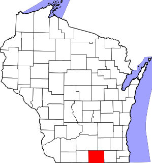
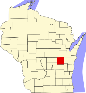
Location of Vernon County in Wisconsin
This is a list of the National Register of Historic Places listings in Vernon County, Wisconsin, USA. It is intended to provide a comprehensive listing of entries in the National Register of Historic Places that are located in Vernon County, Wisconsin. The locations of National Register properties for which the latitude and longitude coordinates are included below may be seen in a map.[1]
Brick warehouse designed by Parkinson & Dockendorff and built in 1906 for Martin Bekkedal, the largest wholesaler of tobacco in the region at the time. Bought in 1921 by the Northern Wisconsin Co-op Tobacco Pool.[10][11]
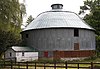
Round barn with walls of clay tile and a tile silo in the center, designed for cows on the lower floor and hay storage above. Possibly designed and constructed by Alga Shivers, a son of a slave who built many of the round barns in Vernon and Monroe counties.[7][14]
Milk-condensing plant built in 1914 by Valecia Condensed Milk, which promptly went bankrupt. A group of local businessmen picked up the project, and the plant canned milk from the surrounding dairy farms until 1956. Then served as a transit point for milk until 1966. The building now houses the Hillsboro Brewing Company.[18]
2-story cream-brick building designed by Parkinson & Dockendorff of La Crosse in Classical Revival style with Beaux Arts influence and built 1921-22, with lodge quarters on the second floor and a theater and shops on the first floor to generate revenue.[22][23]
Rural Lutheran church with two 80-foot towers, designed by Albert Parkinson in Gothic Revival style and built by Theodore Thorson from 1909-10, with windows from the Ford Brothers Glass Company of Minneapolis and altar from the Fond du Lac Church Furniture Company.[24][25]
One-room log pioneer cabin with full dovetail corners, built in 1853 by Skumsrud, an immigrant from Biri, Norway. Now the oldest known remaining dwelling in Vernon County[26][27] and part of Norskedalen.[28]
More than 450 sites dating from 10,000 BC to 1150 CE, in a valley that was almost dammed, including rockshelters, burial mounds, petroglyphs, and prehistoric campsites.[30]
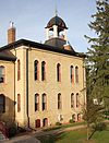
2-story limestone courthouse with a 3-story tower/belfry, designed in High Victorian Gothic style by Carl F. Struck and built in 1880. Murals inside include a scene of settlers arriving in wild Vernon County, painted by Leighton Oyen of LaCrosse.[31][32]
3-story Prairie style building designed by Parkinson & Dockendorff and built in 1919. Nearly 2000 teachers trained here by 1972 when it closed.[33] Now houses the Vernon County Museum.[34]
Viroqua's old commercial business district, including the 1882 Italianate Casson-Purdy Block,[36] the 1899 Queen Anne-styled Fortney Hotel,[37] the 1899 Michel Brewing Co. Building,[38] the 1901 Italianate Dahl/Beat drugstore/grocery,[39] the 1908 Neoclassical First National Bank,[40] the 1921 Neoclassical Masonic Temple/Theatre,[41] the 1930 20th-Century Commercial Felix Store,[42] and the 1939 U.S. Post Office.[43][44]
This is a list of the National Register of Historic Places listings in Dane County, Wisconsin. It aims to provide a comprehensive listing of buildings, sites, structures, districts, and objects in Dane County, Wisconsin listed on the National Register of Historic Places.
This is a list of the National Register of Historic Places listings in Rock County, Wisconsin. It is intended to provide a comprehensive listing of entries in the National Register of Historic Places that are located in Rock County, Wisconsin. The locations of National Register properties for which the latitude and longitude coordinates are included below may be seen in a map.
This is a list of the National Register of Historic Places listings in Waukesha County, Wisconsin. It is intended to provide a comprehensive listing of entries in the National Register of Historic Places that are located in Waukesha County, Wisconsin. The locations of National Register properties for which the latitude and longitude coordinates are included below may be seen in a map.
This is a list of the National Register of Historic Places listings in Jefferson County, Wisconsin. It is intended to provide a comprehensive listing of entries in the National Register of Historic Places that are located in Jefferson County, Wisconsin. The locations of National Register properties for which the latitude and longitude coordinates are included below may be seen in a map.
This is a list of the National Register of Historic Places listings in Winnebago County, Wisconsin.
This is a list of the National Register of Historic Places listings in Fond du Lac County, Wisconsin. It is intended to provide a comprehensive listing of entries in the National Register of Historic Places that are located in Fond du Lac County, Wisconsin. The locations of National Register properties for which the latitude and longitude coordinates are included below may be seen in a map.
This is a list of the National Register of Historic Places listings in Grant County, Wisconsin. It is intended to provide a comprehensive listing of entries in the National Register of Historic Places that are located in Grant County, Wisconsin. The locations of National Register properties for which the latitude and longitude coordinates are included below may be seen in a map.
This is a list of the National Register of Historic Places listings in Iowa County, Wisconsin. It is intended to provide a comprehensive listing of entries in the National Register of Historic Places that are located in Iowa County, Wisconsin. The locations of National Register properties for which the latitude and longitude coordinates are included below may be seen in a map.
This is a list of the National Register of Historic Places listings in La Crosse County, Wisconsin. It is intended to provide a comprehensive listing of entries in the National Register of Historic Places that are located in La Crosse County, Wisconsin. The locations of National Register properties for which the latitude and longitude coordinates are included below may be seen in a map.
This is a list of the National Register of Historic Places listings in Ozaukee County, Wisconsin. It is intended to provide a comprehensive listing of entries in the National Register of Historic Places that are located in Ozaukee County, Wisconsin. The locations of National Register properties for which the latitude and longitude coordinates are included below may be seen in a map.
This is a list of the National Register of Historic Places listings in Sheboygan County, Wisconsin. It is intended to provide a comprehensive listing of entries in the National Register of Historic Places that are located in Sheboygan County, Wisconsin. The locations of National Register properties for which the latitude and longitude coordinates are included below may be seen in a map.
This is a list of the National Register of Historic Places listings in Crawford County, Wisconsin. It is intended to provide a comprehensive listing of entries in the National Register of Historic Places that are located in Crawford County, Wisconsin. The locations of National Register properties for which the latitude and longitude coordinates are included below may be seen in a map.
This is a list of the National Register of Historic Places listings in Dodge County, Wisconsin. It is intended to provide a comprehensive listing of entries in the National Register of Historic Places that are located in Dodge County, Wisconsin. The locations of National Register properties for which the latitude and longitude coordinates are included below may be seen in a map.
This is a list of the National Register of Historic Places listings in Green County, Wisconsin. It is intended to provide a comprehensive listing of entries in the National Register of Historic Places that are located in Green County, Wisconsin. The locations of National Register properties for which the latitude and longitude coordinates are included below may be seen in a map.
This is a list of the National Register of Historic Places listings in Manitowoc County, Wisconsin. It is intended to provide a comprehensive listing of entries in the National Register of Historic Places that are located in Manitowoc County, Wisconsin. The locations of National Register properties for which the latitude and longitude coordinates are included below may be seen in a map.
This is a list of the National Register of Historic Places listings in Green Lake County, Wisconsin. It is intended to provide a comprehensive listing of entries in the National Register of Historic Places that are located in Green Lake County, Wisconsin. The locations of National Register properties for which the latitude and longitude coordinates are included below may be seen in a map.
This is a list of the National Register of Historic Places listings in Price County, Wisconsin. It is intended to provide a comprehensive listing of entries in the National Register of Historic Places that are located in Price County, Wisconsin. The locations of National Register properties for which the latitude and longitude coordinates are included below may be seen in a map.
This is a list of the National Register of Historic Places listings in Wood County, Wisconsin. It is intended to provide a comprehensive listing of entries in the National Register of Historic Places that are located in Wood County, Wisconsin. The locations of National Register properties for which the latitude and longitude coordinates are included below may be seen in a map.
This is a list of the National Register of Historic Places listings in Jackson County, Wisconsin. It is intended to provide a comprehensive listing of entries in the National Register of Historic Places that are located in Jackson County, Wisconsin. The locations of National Register properties for which the latitude and longitude coordinates are included below may be seen in a map.
The Vernon County Courthouse in Viroqua, Wisconsin was built in 1880. It was listed on the National Register of Historic Places in 1980.
References
↑ The latitude and longitude information provided is primarily from the National Register Information System, and has been found to be fairly accurate for about 99% of listings. For 1%, the location info may be way off. We seek to correct the coordinate information wherever it is found to be erroneous. Please leave a note in the Discussion page for this article if you believe any specific location is incorrect.
↑ Numbers represent an alphabetical ordering by significant words. Various colorings, defined here, differentiate National Historic Landmarks and historic districts from other NRHP buildings, structures, sites or objects.
↑ The eight-digit number below each date is the number assigned to each location in the National Register Information System database, which can be viewed by clicking the number.
1 2 Caya, Susan R.; Penkiunas, Daina (2004-05-01). "Apfel, George, Round Barn". NRHP Inventory-Nomination Form. National Park Service. Retrieved 2015-11-15.
This page is based on this Wikipedia article Text is available under the CC BY-SA 4.0 license; additional terms may apply. Images, videos and audio are available under their respective licenses.