North Plains, Oregon

Last updated

North Plains, Oregon
North Plains Oregon city hall.JPG
City Hall
Seal of North Plains, Oregon.jpg
Nickname: 
City to the Sunset
Washington County Oregon Incorporated and Unincorporated areas North Plains Highlighted.svg
Location in Oregon
Coordinates: 45°35′52″N122°59′53″W / 45.59778°N 122.99806°W / 45.59778; -122.99806
Country United States
State Oregon
County Washington
Incorporated 1963
Government
   Mayor Teri Lenahan[ citation needed ]
Area
[1]
  Total1.09 sq mi (2.82 km2)
  Land1.09 sq mi (2.82 km2)
  Water0.00 sq mi (0.00 km2)
Elevation
[2]
207 ft (63 m)
Population
 (2020) [3]
  Total3,441
  Density3,156.88/sq mi (1,218.66/km2)
Time zone UTC-8 (Pacific)
  Summer (DST) UTC-7 (Pacific)
ZIP code
97133
Area code 503
FIPS code 41-53150 [4]
GNIS feature ID2411276 [2]
Website www.northplains.org

North Plains is a city in Washington County, Oregon, United States, off U.S. 26 on the northwest outskirts of the Portland metropolitan area. The population was 3,441 at the 2020 census.

Contents

History

Pioneer settlers first arrived in the North Plains area in the 1840s. [5] The area to be known as the city of North Plains was platted in September 1910 by the Ruth Trust Company of Portland. They purchased area tracts after James J. Hill planned to extend United Railways there. [6] [7]

On June 25, 1963, North Plains voted 90 to 56 to incorporate as a city; at the time the population was around 500. [5]

Pumpkin Ridge Golf Club is just outside town. David Duval won the Nike Tour Championship there in 1993, and it was home to the U.S. Women's Open in 1997 and 2003. [8] Horning's Hideout within the North Plains area was home to Faerieworlds Festival 2004. [9] Pumpkin Ridge Golf Club has become a center of controversy since agreeing to host the first U.S. golf tournament on American soil of LIV Golf , the tour backed by bin Salman and Saudi Arabia’s Public Investment Fund. [10]

Geography

According to the United States Census Bureau, the city has an area of 0.90 square miles (2.33 km2), all land. [11]

Climate

This region has warm, dry summers, with no monthly average temperatures above 71.6 °F (22 °C). However, temperatures are often above 100 °F (38 °C) for several days each year. According to the Köppen Climate Classification system, North Plains has a warm-summer Mediterranean climate, abbreviated "Csb" on climate maps. [12]

Demographics

Historical population
CensusPop.Note
1970 690
1980 7153.6%
1990 97235.9%
2000 1,60565.1%
2010 1,94721.3%
2020 3,44176.7%
U.S. Decennial Census [13] [3]
North Plains Library North Plains Oregon library.JPG
North Plains Library

2010 census

As of the census [14] of 2010, there were 1,947 people (a 21.3% increase from 2000), 706 households, and 511 families living in the city. The population density was 2,163.3 inhabitants per square mile (835.3/km2). There were 749 housing units at an average density of 832.2 per square mile (321.3/km2). The racial makeup of the city was 89.0% White, 0.4% African American, 1.2% Native American, 1.8% Asian, 0.6% Pacific Islander, 3.1% from other races, and 3.7% from two or more races. Hispanic or Latino of any race were 11.0% of the population.

There were 706 households, of which 40.8% had children under the age of 18 living with them, 58.5% were married couples living together, 9.3% had a female householder with no husband present, 4.5% had a male householder with no wife present, and 27.6% were non-families. 21.8% of all households were made up of individuals, and 9.2% had someone living alone who was 65 years of age or older. The average household size was 2.75 and the average family size was 3.21.

The median age in the city was 36.5 years. 27.5% of residents were under the age of 18; 7.2% were between the ages of 18 and 24; 28.6% were from 25 to 44; 27.3% were from 45 to 64; and 9.2% were 65 years of age or older. The gender makeup of the city was 49.6% male and 50.4% female.

2000 census

As of the census [4] of 2000, there were 1,605 people, 594 households, and 422 families living in the city. The population density was 2,044.7 inhabitants per square mile (789.5/km2). There were 633 housing units at an average density of 806.4 per square mile (311.4/km2). The racial makeup of the city was 90.78% White, 1.87% Asian, 1.68% Native American, 0.12% African American, 0.12% Pacific Islander, 2.74% from other races, and 2.68% from two or more races. Hispanic or Latino of any race were 7.10% of the population. On a percentage basis, North Plains is among the top 100 locations (with at least 500 residents) home to Panamanian Americans. [15]

There were 594 households, out of which 40.9% had children under the age of 18 living with them, 58.8% were married couples living together, 8.8% had a female householder with no husband present, and 28.8% were non-families. 25.6% of all households were made up of individuals, and 12.1% had someone living alone who was 65 years of age or older. The average household size was 2.70 and the average family size was 3.24.

In the city, the population was spread out, with 30.0% under the age of 18, 5.6% from 18 to 24, 35.0% from 25 to 44, 18.8% from 45 to 64, and 10.7% who were 65 years of age or older. The median age was 34 years. For every 100 females, there were 97.7 males. For every 100 females age 18 and over, there were 92.3 males.

The median income for a household in the city was $49,563, and the median income for a family was $55,156. Males had a median income of $42,237 versus $27,857 for females. The per capita income for the city was $18,794. About 4.8% of families and 5.3% of the population were below the poverty line, including 3.8% of those under age 18 and 15.8% of those age 65 or over.

Presidential election results [16]
Year DEM GOP Others
2020 52.1%1,00644.3% 8553.6% 69
2016 40.9% 55944.0%60215.1% 207
2012 48.3%45747.4% 4494.3% 41
2008 52.1%50343.5% 4204.5% 43
2004 44.4% 36254.2%4421.3% 11
2000 49.0%32945.6% 3095.1% 34

Politics

Politically, North Plains is competitive. Precinct 330, which comprises the entirety of the city, voted 52% to 44% for Democrat Joe Biden over Republican Donald Trump in the 2020 election, after voting for Trump over Hillary Clinton 44% to 41% in 2016.

See also


Related Research Articles

<span class="mw-page-title-main">Belle Plaine, Iowa</span> City in Iowa, United States

Belle Plaine is a city in Benton County, Iowa, United States. The population was 2,330 at the 2020 census. It is part of the Cedar Rapids Metropolitan Statistical Area.

<span class="mw-page-title-main">Canby, Oregon</span> City in Oregon, United States

Canby is a city in Clackamas County, Oregon, United States. The population was 18,171 at the 2020 census. It is along Oregon Route 99E, 2 miles (3 km) northeast of Barlow.

<span class="mw-page-title-main">Happy Valley, Oregon</span> City in Oregon, United States

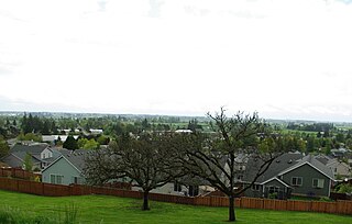
Happy Valley is a suburban city in the Portland, Oregon metropolitan area. Happy Valley is near the northwest edge of Clackamas County, Oregon, United States approximately 10 miles to the southeast of downtown Portland, Oregon. The population was 23,733 at the 2020 census.

<span class="mw-page-title-main">Columbia City, Oregon</span> City in Oregon, United States

Columbia City is a city in Columbia County, Oregon, United States. It was named for its location on the Columbia River. The population was 1,946 at the 2010 census.

<span class="mw-page-title-main">Myrtle Creek, Oregon</span> City in Oregon, United States

Myrtle Creek is a city in Douglas County, Oregon, United States. The population was 3,439 at the 2010 census.

<span class="mw-page-title-main">Mount Vernon, Oregon</span> City in Oregon, United States

Mount Vernon is a city in Grant County, Oregon, United States. Its post office was established in 1877 and named after a black stallion that belonged to settler David W. Jenkins. The stallion's stable, a small stone building, is still standing in a field on the north side of U.S. Highway 26 about 2.2 miles (3.5 km) east of the main intersection in town. In 1915 the ranching community had a population of 60 and a hotel at a hot springs resort approximately 2 miles (3.2 km) north. The population had grown to 451 by the 1950 census. There are a few motels and restaurants in Mount Vernon. The population was 527 at the 2010 census.

<span class="mw-page-title-main">Central Point, Oregon</span> City in Oregon, United States

Central Point is a city in Jackson County, Oregon, United States. The population was 17,169 as of 2010. The city shares its southern border with Medford and is a part of the Medford metropolitan area. Central Point is home of the Jackson County Fair that occurs in July.

<span class="mw-page-title-main">Scotts Mills, Oregon</span> City in Oregon, United States

Scotts Mills is a city in Marion County, Oregon, United States. The population was 419 at the 2020 census. It is 2 miles (3 km) south of Marquam and Oregon Route 213, between Silverton and Molalla.

<span class="mw-page-title-main">Troutdale, Oregon</span> City in Oregon, United States

Troutdale is a city in Multnomah County, Oregon, United States, immediately north of Gresham and east of Wood Village. As of the 2020 census, the city population was 16,300. The city serves as the western gateway to the Historic Columbia River Highway, the Mount Hood Scenic Byway, and the Columbia River Gorge. It is approximately 12 miles (19 km) east of Portland.

<span class="mw-page-title-main">Wheeler, Tillamook County, Oregon</span> City in Oregon, United States

Wheeler is a city in Tillamook County, Oregon, United States. The population was 414 at the 2010 census. It is named after Coleman Wheeler, who opened a sawmill in the town and had a lumber business; Coleman is a great-grandfather of Ted Wheeler, who as of 2023 is mayor of Portland, Oregon.

<span class="mw-page-title-main">Stanfield, Oregon</span> City in Oregon, United States

Stanfield is a city in Umatilla County, Oregon, United States. The population was 2,043 at the 2010 census. It is part of the Pendleton–Hermiston Micropolitan Statistical Area.

<span class="mw-page-title-main">Union, Oregon</span> City in Oregon, United States

Union is a city in Union County, Oregon, United States, originally platted in 1864, and located 15 miles (24 km) southeast of La Grande. It is the namesake of Union County, which references the Union states, or Northern States, of the American Civil War. The population was 2,152 at the 2020 census. The city is known for the numerous historic Victorian homes that line its Main Street, some of which are registered on the National Register of Historic Places. It is also home to Oregon State University's Eastern Oregon Agricultural Research Center, founded in 1888, which is contemporarily housed in the former Union train station.

<span class="mw-page-title-main">Cornelius, Oregon</span> City in Oregon, United States

Cornelius is a city in Washington County, Oregon, United States. Located in the Portland metropolitan area, the city's population was 11,869 at the 2010 census. The city lies along Tualatin Valley Highway between Forest Grove to the west and Hillsboro to the east. Cornelius was incorporated in 1893 and is named for founder Thomas R. Cornelius.

<span class="mw-page-title-main">Durham, Oregon</span> City in Oregon, United States

Durham is a city in Washington County, Oregon, United States. Incorporated in 1966, the city is surrounded by Tigard and Tualatin and is adjacent to the Bridgeport Village shopping complex. The population was 1,351 at the 2010 census.

<span class="mw-page-title-main">Forest Grove, Oregon</span> City in Oregon, United States

Forest Grove is a city in Washington County, Oregon, United States, 25 miles (40 km) west of Portland. Originally a small farm town, it is now primarily a commuter town in the Portland metro area. Settled in the 1840s, the town was platted in 1850, then incorporated in 1872, making it the first city in Washington County. The population was 21,083 at the 2010 census, an increase of 19.1% over the 2000 figure (17,708).

<span class="mw-page-title-main">Garden Home–Whitford, Oregon</span> CDP in Oregon, United States

Garden Home-Whitford is a census-designated place (CDP) consisting of the neighborhoods of Garden Home and the smaller Whitford area in Washington County, Oregon, United States. They are located in the southwest hills of Portland, near Beaverton. As of the 2020 census, the CDP population was 7,081.

<span class="mw-page-title-main">Sherwood, Oregon</span> City in Oregon, United States

Sherwood is a city in Washington County, Oregon, United States. Located in the southeast corner of the county, it is a residential community in the Tualatin Valley, southwest of Portland. As of the 2010 census, Sherwood had a population of 18,194 residents. The city's population for 2019 was estimated to be 19,879 by the U.S. Census. Sherwood was first incorporated in 1893 as a town. Originally named Smockville after its founder, James Christopher Smock, the town was given its current name by local businessman Robert Alexander in 1891. The name "Sherwood" may have come from Sherwood, Michigan or the Sherwood Forest in England.

<span class="mw-page-title-main">Dundee, Oregon</span> City in Oregon, United States

Dundee is a city in Yamhill County, Oregon, United States. The population was 3,238 at the 2020 census.

<span class="mw-page-title-main">Rivergrove, Oregon</span> City in Oregon, United States

Rivergrove is a city in Clackamas County, Oregon, United States. A small portion of the city extends into nearby Washington County. Its name is a portmanteau of the Tualatin River, which forms its southern border, and Lake Grove, a community that is now part of Lake Oswego. The population was 370 at the 2010 census.

<span class="mw-page-title-main">Portland, Texas</span> City in Texas, United States

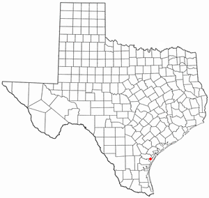
Portland is a city in Nueces and San Patricio Counties in the U.S. state of Texas. Its population was 20,383 as of the 2020 United States census. Portland is a suburb of Corpus Christi, located on the north shore of Nueces and Corpus Christi Bays.

References

  1. "ArcGIS REST Services Directory". United States Census Bureau. Retrieved October 12, 2022.
  2. 1 2 U.S. Geological Survey Geographic Names Information System: North Plains, Oregon
  3. 1 2 "Census Population API". United States Census Bureau. Retrieved October 12, 2022.
  4. 1 2 "U.S. Census website". United States Census Bureau . Retrieved January 31, 2008.
  5. 1 2 "History". City of North Plains. Retrieved January 13, 2021.
  6. "North Plains History". Hillsboro Argus article dated June 25, 1963. City of North Plains. Archived from the original on December 7, 2008. Retrieved August 4, 2009. The brochure points out in part six months after the first train was run over the United Railways in January 1911, "The new town boasted a permanent population of 200, and after a year's growth, North Plains is a thriving town of 400."...[The first plat was drawn in] September 1910 by Newell Gossett & Walsh Engineers for the Ruth Trust Co.
  7. According to the Pacific Northwest Chapter of the National Railway Historical Society, United Railways was a Portland area short line. They "operated one streetcar line, industrial trackage in Portland, and a logging and passenger line from northwest Portland to Banks, Vernonia, Keasey and beyond." The passenger service operated out of North Bank Station, a former freight-only depot at the corner of NW 11th and Hoyt, now known as the Pearl Townhouses. In 1944, United Railways was taken over by Spokane, Portland and Seattle Railway.
  8. 2003 Fact Sheet from the U.S. Women's Open Championship website
  9. Review of Faerieworlds Festival 2004 from the Faerieworlds website
  10. The Washington Post, "Before it even arrives, golf’s rogue tour roils a small Oregon town," by Molly Hensley-Clancy, June 25, 2022
  11. "US Gazetteer files 2010". United States Census Bureau. Archived from the original on February 20, 2011. Retrieved December 21, 2012.
  12. Climate Summary for North Plains, Oregon
  13. "Census of Population and Housing". Census.gov. Retrieved June 4, 2015.
  14. "U.S. Census website". United States Census Bureau . Retrieved December 21, 2012.
  15. Top 101 cities with the most residents born in Panama (population 500+) from city-data.com
  16. "Elections Archive". Washington County, Oregon. Retrieved January 13, 2021.