November 2006 nor'easter

Last updated

November 2006 nor'easter
Late November 2006 nor'easter.gif
Nor'easter just past its initial peak intensity moving into North Carolina
Type Extratropical cyclone
Nor'easter
FormedNovember 20, 2006
DissipatedDecember 1, 2006
Lowest pressure944 mbar (hPa)
Maximum snowfall
or ice accretion
5 inches (13 cm)
Fatalities1
DamageNot yet known
Areas affected East Coast of the United States, Southern Greenland, Iceland, Ireland, United Kingdom

The November 2006 nor'easter was a powerful extratropical cyclone that formed offshore of the Southeastern United States on November 20, bringing heavy rains, high winds, beach erosion, and coastal flooding to the Carolinas and southern New England. In addition, the earliest snowfall ever noted in both Charleston, South Carolina and Savannah, Georgia occurred on the southwest side of this cyclone. Over 10,000 were without power during the storm. No longer a nor'easter, the extratropical cyclone accelerated rapidly across the North Atlantic while rapidly strengthening, becoming a cyclonic storm again by November 25, but this time with hurricane-force sustained winds. The intense low made a cyclonic loop west of Iceland, before being absorbed by another strengthening extratropical cyclone to the west of Great Britain, late on December 1.

Contents

Meteorological synopsis

A shortwave moved through the southern stream of the polar jet of the Westerlies, dropping temperatures in its wake across the southeast United States. Cyclogenesis spurred a developing surface cyclone which quickly occluded on November 20. Surface pressure gradient between this cyclone and a sprawling high stretching around its periphery from New England into the Deep South led to strong winds in the Carolinas. The cyclone deepened to a central pressure of 999 hectopascals (29.5 inHg) before swinging westward into the Outer Banks of North Carolina on November 22. At this time, a trio of upper-level shortwaves were rotating around the main closed cyclone aloft, which spurred development of a new, weaker low pressure center offshore North Carolina. This cyclone was weaker after its interaction with North Carolina until it reached New England, when renewed strengthening led to significant impacts across Long Island and southern New England. The system then began accelerating east-northeast while continuing to slowly strengthen, passing offshore Atlantic Canada on November 24. The cyclone subsequently bombed, or strengthened quite rapidly, and accelerated east-northeast, becoming a hurricane-force storm in the far north Atlantic with a central pressure of 967 hectopascals (28.6 inHg) by the afternoon of November 25 and peaking at 944 hectopascals (27.9 inHg) by the morning of November 26. [1] Slow weakening occurred soon afterward as the system slowed down and turned towards Iceland. By the evening of November 27, its central pressure had increased to 957 hectopascals (28.3 inHg) while located a couple hundred miles south of Iceland. The cyclone continued to loop cyclonically west of Iceland, absorbing a cyclone along the way as it passed southwest off the southern tip of Greenland, before a developing gale approaching Great Britain absorbed this cyclone late on December 1. [2]

Preparations

Surface analysis from November 22, 2006 at 1200 UTC showing the cyclone moving into mainland North Carolina Namussfc2006112212.gif
Surface analysis from November 22, 2006 at 1200 UTC showing the cyclone moving into mainland North Carolina

There had been indications in the forecast model guidance as early as the first week of November that weather would be unsettled/rainy across the eastern United States around November 23. Within seven days of the event, medium range forecasts generally maintained the idea of a coastal storm offshore the Southeast, though its progression out to sea remained uncertain until November 21, after the cyclone actually formed offshore the Southeast United States and began edging northeast.

Virginia

On the Chesapeake Bay Bridge-Tunnel, officials restricted the types of vehicles that could cross the span between Virginia Beach and the Eastern Shore to cars and pickup trucks. Poquoson Public Schools were closed, and the Midtown Tunnel between Norfolk and Portsmouth was shut down because of the possibility of flooding. Sandbags surrounded buildings at Langley Air Force Base, which lies 11 feet (3.4 m) above sea level, and all computers and electrical equipment were waterproofed. [3]

Maryland

The Maryland State Highway Administration worked to clear storm drains of branches and leaves and called in more patrollers to assist motorists in the event of an accident or stranded vehicle. The administration also prepared for falling branches, by making sure the department's chain saws had enough gas. [4]

Effects

Florida

Snow flurries fell as far south as central Florida on the backside of this system. Snow flurries were reported in Orange, Seminole, and Volusia Counties. [5] It was the earliest snow had ever fallen this far south, and only the second time on record snow had fallen in Florida in November.[ citation needed ]

Georgia

Snow mixed in with rain around noon on November 21, which led to the earliest trace of snow on record in Savannah. Just inland, 5–7 inches of snow fell across extreme southeast Georgia.

South Carolina

Snowfall map for South Carolina SnowTotalsNov212006.jpg
Snowfall map for South Carolina

Heavy rains fell across northern portions of the state, with 4.13 inches (105 mm) measured at Chester. Snow mixed in with rain during the morning of November 21, leading to the earliest trace of snow on record in Charleston. Also, as the snow mixed in, thunder was heard, which is the first report of thundersnow in the history of Charleston. An inch of snow was reported just inland. Winds gusted to 44 mph (38 knots) at Folly Beach. The combination of pounding surf and high winds led to moderate to heavy beach erosion at Hunting Island, Folly Beach, Isle of Palms, Wild Dunes, and Sullivan's Island. [6]

North Carolina

Heavy rainfall fell throughout central and eastern North Carolina, with the maximum amount of 7.68 inches (195 mm) measured at Sandy Run. This precipitation combined with high tides led to river flooding across the eastern half of the state, and led to Raleigh-Durham International Airport setting a record for its wettest November on record, breaking the record from 1948. The combination of wind and rain led to the downing of numerous trees. Winds gusted to 70 knots (80 mph) at Alligator River, with numerous gusts above 50 knots (60 mph) throughout the Outer Banks, leading to beach erosion and coastal flooding, with Highway 12 being overwashed by the surge south of Oregon Inlet. [7] Power went out to 1,250 in northeastern sections of the state. [8] The combination of coastal flooding and heavy rains led to the Lumber River rising to 3.5 feet (1.1 m) above flood stage. In Nags Head, 54 homes were condemned due to damage from this cyclone. [9] At sea, the container ship Courtney L lost four containers on November 22 or 23 due to the storm. One of them, which contained Doritos bound for Costa Rica, was eventually washed ashore near Cape Hatteras. [10] [11]

Virginia

High winds lashed extreme southeast sections of the state. The highest wind gust reported was 66 mph (57 knots) from the first island on the Chesapeake Bay Bridge-Tunnel at 9:45 a.m. EST. In southeast sections of the state, over 9000 went without power. [12] Moderate to heavy rain fell across the tidewater, with 1.97 inches (50 mm). [13] One person perished when the car he was driving hydroplaned and subsequently crashed. [8]

A brief period of sleet was experienced across Northern Virginia on the morning of November 22 as moisture from the storm moved in from a northeast-to-southwest track. This form of precipitation is rare for the area in mid-November, but was quickly replaced by driving rainfall as warmer air from the Atlantic pushed inland. Steady rain persisted throughout the afternoon and evening of the 22nd, with a mix of showers and moderate-to-heavy mist occurring throughout Thanksgiving Day, November 23.

Maryland

Winds as high as 54 mph (47 knots) lashed Assateague Island. The highest rainfall amount reported was 2.12 inches (54 mm) from Ocean City. [13]

Delaware

Georgetown reported a record rainfall for November 22, when 1.93 inches (49 mm) was measured; [14] a total of 2.50 inches (64 mm) fell. [15]

Pennsylvania

Image of storm near its peak intensity to the west of the British Isles during the late morning of November 26 Satellite Image of Oceanic hurricane-force storm, 2006.gif
Image of storm near its peak intensity to the west of the British Isles during the late morning of November 26

Rainfall amounts ranged at high as 1.21 inches (31 mm) at Lehighton. [15]

New Jersey

Winds peaked at 57 mph (50 knots) at both Cape May Harbor and Ocean City. At Newark, the 1.26 inches (32 mm) that fell on November 23 set a daily precipitation record for the date. [16] The highest amount noted was 2.57 inches (65 mm) at the United States Coast Guard site in Atlantic City. [15]

An oak tree toppled onto a house located in West Deptford. A tree also got caught in a power line in Vivian Court, so the electric power had to be cut, so the power line could be cleared of the tree. A traffic light and some trees were also damaged in Northfield. Minor flooding was also reported in some back-bays, which forced some intersections to be closed. [17]

New York

Low level wind shear led to moderate delays of an hour or more at major airports within the megalopolis on the morning of November 22, the day before Thanksgiving in the United States. At Kennedy Airport, 1.56 inches (40 mm) of rainfall set a daily precipitation record for November 23. The highest amount reported was 2.83 inches (72 mm) at Shoreham. [18] Around Binghamton, a light coating of ice covered surfaces as a slight amount of freezing rain fell. [16]

Connecticut

At Bridgeport, rainfall of 1.84 inches (47 mm) fell on November 23, setting a daily rainfall record. The highest amount reported was 3.27 inches (75 mm) at Norwich. [18]

Rhode Island

High winds downed a telephone pole in Warwick, and numerous tree limbs throughout the state. [19] Downtown Providence reported 3.91 inches (99 mm) of rainfall on November 23 and November 24. [20] This rain led to minor flooding of the Pawtuxet River in Cranston, an area hard-hit by the flooding in October, 2005. [21]

Massachusetts

High winds downed numerous tree limbs throughout the state. A total of 2.09 inches (53 mm) of rainfall fell in Boston as of the morning of November 24. [22] The highest amount reported was 4.76 inches (121 mm) at Hingham. [23]

See also

Related Research Articles

<span class="mw-page-title-main">Groundhog Day gale of 1976</span> Severe winter storm in North America

The Groundhog Day gale was a severe winter storm that hit the Northeastern United States and southeastern Canada on February 2, 1976.

<span class="mw-page-title-main">Hurricane Gracie</span> Category 4 Atlantic hurricane in 1959

Hurricane Gracie was a major hurricane that formed in September 1959, the strongest during the 1959 Atlantic hurricane season and the most intense to strike the United States since Hurricane Hazel in 1954. The system was first noted as an area of thunderstorms east of the Lesser Antilles which moved just north of the Greater Antilles, quickly intensifying into a hurricane on September 22. Gracie was a storm that was very difficult to forecast, with its movement unpredictable. After five days of erratic motion, Gracie became a major hurricane which struck South Carolina, and weakened as it moved up the Appalachians, bringing much needed rain to a drought-plagued region. Much of the destruction related with Gracie was centered on Beaufort, South Carolina. Gracie became an extratropical cyclone on September 30 while moving through the Eastern United States.

<span class="mw-page-title-main">1939 California tropical storm</span> Category 1 Pacific hurricane in 1939

The 1939 California tropical storm, also known as the 1939 Long Beach tropical storm, and El Cordonazo, was a tropical cyclone that affected Southern California in September 1939. Formerly a hurricane, it was the only tropical storm to make landfall in California in the twentieth century. Fisherman in the villages along the Mexican coast have named these storms, the Lash of St. Francis. The only other known tropical cyclone to directly affect California at tropical storm intensity or higher is the 1858 San Diego hurricane, and only three other eastern Pacific tropical cyclones have produced gale-force winds in the continental United States. The tropical storm caused heavy flooding, leaving many dead, mostly at sea.

<span class="mw-page-title-main">Hurricane Gordon (2000)</span> Category 1 Atlantic hurricane in 2000

Hurricane Gordon caused minor damage in the Eastern United States. The seventh named storm and fourth hurricane of the 2000 Atlantic hurricane season, Gordon developed in the extreme western Caribbean Sea from a tropical wave on September 14. Shortly thereafter, the depression moved inland over the Yucatán Peninsula and later emerged into the Gulf of Mexico on September 15. The depression began to quickly organize, and by early on September 16, it was upgraded to Tropical Storm Gordon. After becoming a tropical storm, Gordon continued to intensify and was reclassified as a hurricane about 24 hours later; eventually, the storm peaked as an 80 mph (130 km/h) Category 1 hurricane. However, southwesterly upper-level winds caused Gordon to weaken as it approached land, and it was downgraded to a tropical storm by late on September 17. At 0300 UTC on September 18, Gordon made landfall near Cedar Key, Florida as a strong tropical storm. After moving inland, Gordon rapidly weakened and had deteriorated to tropical depression status by nine hours later. Later that day, Gordon merged with a frontal boundary while centered over Georgia.

The 1940 South Carolina hurricane was a Category 2 hurricane that struck the Georgia and South Carolina coast between August 11 and 12, 1940. After forming north of the Leeward Islands, the storm moved west-northwest, moving east of the Bahamas before resuming a west-northwest track towards the Southeastern United States. Hurricane warnings were in effect for the United States coastline near and north of where the center made landfall. A 13-foot storm tide was measured along the South Carolina coast, while over 15 inches (380 mm) of rain fell across northern North Carolina. Significant flooding and landslides struck Georgia, North Carolina, Tennessee, and Virginia during the system's slow trek as a weakening tropical storm, and then as an extratropical cyclone, through the Southeast. The landslides which struck North Carolina were considered a once in a century event. Damages relating to the storm totaled $13 million and 50 people perished.

<span class="mw-page-title-main">Tropical Storm Claudette (1979)</span>

Tropical Storm Claudette was a 1979 tropical cyclone which was the third-wettest tropical cyclone on record in the contiguous United States. The storm caused significant flooding in eastern Texas and western Louisiana in July 1979. The eighth tropical cyclone and third named storm of the 1979 Atlantic hurricane season, Claudette developed from a tropical wave located east of the Windward Islands on July 16. It gradually strengthened and was upgraded to a tropical storm on July 17 and crossed the northern Leeward Islands later that day. As it neared landfall in Puerto Rico early on July 18, upper-level winds weakened it back to a tropical depression. Claudette remained disorganized and the National Hurricane Center operationally reported that it degenerated back into a tropical wave after crossing Puerto Rico. Late on July 18, the depression struck Dominican Republic, emerged into the Caribbean Sea on the following day. Claudette struck western Cuba on July 21, shortly before reaching the Gulf of Mexico and "regenerating" into a tropical cyclone. By July 23, Claudette regained tropical storm intensity and turned northward toward the Gulf Coast of the United States. The storm made landfall near the Texas-Louisiana border late on July 23 as a moderately strong tropical storm. It weakened slowly and drifted over land, lasting until dissipation in West Virginia on July 29.

<span class="mw-page-title-main">Tropical Storm Alberto (2006)</span> Atlantic tropical cyclone

Tropical Storm Alberto was the first tropical storm of the 2006 Atlantic hurricane season. Forming on June 10 in the northwestern Caribbean, the storm moved generally to the north, reaching a maximum intensity of 70 mph (110 km/h) before weakening and moving ashore in the Big Bend area of Florida on June 13. Alberto then moved through eastern Georgia, North Carolina, and Virginia as a tropical depression before becoming extratropical on June 14.

<span class="mw-page-title-main">Tropical Storm Doria</span> Atlantic tropical storm in 1971

Tropical Storm Doria was the costliest tropical cyclone in the 1971 Atlantic hurricane season. The fifth tropical storm of the season, Doria developed from a tropical wave on August 20 to the east of the Lesser Antilles, and after five days without development it attained tropical storm status to the east of Florida. Doria turned to the north, and reached peak winds of 65 mph (105 km/h) as it was making landfall near Morehead City, North Carolina. It turned to the northeast, and moved through the Mid-Atlantic and New England as a tropical storm before becoming an extratropical storm over Maine on August 29.

<span class="mw-page-title-main">Tropical Storm Edouard (2002)</span> Atlantic tropical cyclone

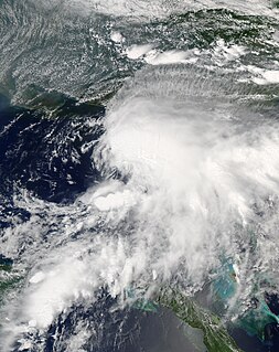
Tropical Storm Edouard was the first of eight named storms to form in September 2002, the most such storms in the North Atlantic for any month at the time. The fifth tropical storm of the 2002 Atlantic hurricane season, Edouard developed into a tropical cyclone on September 1 from an area of atmospheric convection associated with a cold front east of Florida. Under weak steering currents, Edouard drifted to the north and executed a clockwise loop to the west. Despite moderate to strong levels of wind shear, the storm reached a peak intensity of 65 mph (100 km/h) on September 3, but quickly weakened as it tracked westward. Edouard made landfall on northeastern Florida on September 5, and after crossing the state it dissipated on September 6 while becoming absorbed into the larger circulation of Tropical Storm Fay.

<span class="mw-page-title-main">Tropical Storm Marco (1990)</span> 1990 Atlantic tropical storm

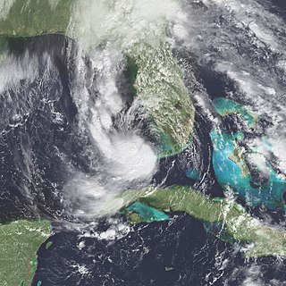
Tropical Storm Marco was the only tropical cyclone to make landfall on the United States during the 1990 Atlantic hurricane season. The 13th named storm of the season, Marco formed from a cold-core low pressure area along the northern coast of Cuba on October 9, and tracked northwestward through the eastern Gulf of Mexico. With most of its circulation over the western portion of Florida, Tropical Storm Marco produced 65 mph (100 km/h) winds over land. However, it weakened to a tropical depression before moving ashore near Cedar Key. The cyclone combined with a cold front and the remnants of Hurricane Klaus to produce heavy rainfall in Georgia and the Carolinas. After interacting with the nearby Hurricane Lili, Marco continued northward until being absorbed by a cold front on October 13.

<span class="mw-page-title-main">United States rainfall climatology</span> Characteristics of weather in U.S.

The characteristics of United States rainfall climatology differ significantly across the United States and those under United States sovereignty. Late summer and fall tropical cyclones bring precipitation which falls across the Gulf and Atlantic states. During the winter, and spring, Pacific storm systems bring Hawaii and the western United States most of their precipitation. Low pressure systems moving up the East coast bring cold season precipitation to the Mid-West and Northeast states, as well as Great Salt Lake and the Finger Lakes region. The snow to liquid ratio across the contiguous United States averages 13:1, meaning 13 inches (330 mm) of snow melts down to 1 inch (25 mm) of water.

<span class="mw-page-title-main">Tropical Storm Barry (2007)</span> Atlantic tropical cyclone

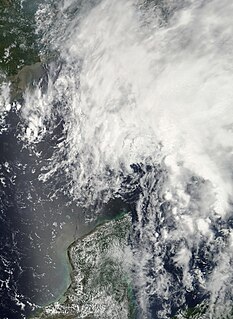
Tropical Storm Barry was a rapidly forming tropical cyclone that made landfall on Florida, United States, in early June 2007. The second named storm of the 2007 Atlantic hurricane season, Barry developed from a trough of low pressure in the southeastern Gulf of Mexico on June 1. It tracked rapidly northeastward, reaching peak winds of 60 mph (95 km/h) before weakening and making landfall near Tampa Bay as a tropical depression. Barry quickly lost tropical characteristics after wind shear removed much of the convection, and early on June 3, it completed the transition into an extratropical cyclone. The extratropical remnants tracked up the East Coast of the United States, and were absorbed by a larger extratropical cyclone on June 5.

<span class="mw-page-title-main">Hurricane Noel</span> Category 1 Atlantic hurricane in 2007

Hurricane Noel was a deadly and very damaging tropical cyclone that carved a path of destruction across the Atlantic Ocean from the Caribbean Sea to Newfoundland in late October 2007. The sixteenth tropical depression, fourteenth named storm, and the sixth hurricane of the 2007 Atlantic hurricane season, Noel formed on October 27 from the interaction between a tropical wave and an upper-level low in the north-central Caribbean. It strengthened to winds of 60 mph (97 km/h) before making landfall on western Haiti and the north coast of eastern Cuba. Noel turned northward, and on November 1, it attained hurricane status. The hurricane accelerated northeastward after crossing the Bahamas, and on November 2, it transitioned into an extratropical cyclone.

<span class="mw-page-title-main">Climate of North Carolina</span> Overview of the climate of the U.S. state of North Carolina

North Carolina's climate varies from the Atlantic coast in the east to the Appalachian Mountain range in the west. The mountains often act as a "shield", blocking low temperatures and storms from the Midwest from entering the Piedmont of North Carolina.

Global weather activity of 2006 profiles the major worldwide weather events, including blizzards, ice storms, tropical cyclones, tornadoes, and other weather events, from January 1, 2006, to December 31, 2006. Winter storms are events in which the dominant varieties of precipitation are forms that only occur at cold temperatures, such as snow or sleet, or a rainstorm where ground temperatures are cold enough to allow ice to form. It may be marked by strong wind, thunder and lightning, heavy precipitation, such as ice, or wind transporting some substance through the atmosphere. Other major non winter events such as large dust storms, Hurricanes, cyclones, tornados, gales, flooding and rainstorms are also caused by such phenomena to a lesser or greater existent.

<span class="mw-page-title-main">1960 Texas tropical storm</span> Atlantic tropical storm in 1960

The 1960 Texas tropical storm brought severe but localized flooding to southeastern Texas in June 1960. The first tropical cyclone and first tropical storm of the 1960 Atlantic hurricane season, this system developed from an area of showers and thunderstorms in the Bay of Campeche on June 22. Initially a tropical depression, it strengthened and was estimated to have reached tropical storm status on June 23. Early on the following day, the storm peaked with winds of 60 mph (95 km/h). Later that day, it made landfall near Corpus Christi, Texas, at the same intensity. The storm weakened slowly and moved across the Central United States, before dissipating over Illinois on June 28.

<span class="mw-page-title-main">Hurricane Cindy (1959)</span> Category 1 Atlantic hurricane in 1959

Hurricane Cindy impacted the Carolinas, the Mid-Atlantic states, New England, and the Canadian Maritime Provinces during the 1959 Atlantic hurricane season. The third storm of the season, Cindy originated from a low-pressure area associated with a cold front located east of northern Florida. The low developed into a tropical depression on July 5 while tracking north-northeastward, and became Tropical Storm Cindy by the next day. Cindy turned westward because of a high-pressure area positioned to its north, and further intensified into a weak hurricane off the coast of the Carolinas on July 8. Early on July 9, Cindy made landfall near McClellanville, South Carolina, and re-curved to the northeast along the Fall Line as a tropical depression. It re-entered the Atlantic on July 10, quickly restrengthening into a tropical storm while it began to move faster. On July 11, Cindy passed over Cape Cod, while several other weather systems helped the storm maintain its intensity. Cindy transitioned into an extratropical cyclone on July 12 as it neared the Canadian Maritime Provinces.

<span class="mw-page-title-main">Tropical Storm Andrea (2013)</span> Atlantic Tropical storm in the 2013

Tropical Storm Andrea brought flooding to Cuba, the Yucatan Peninsula, and portions of the East Coast of the United States in June 2013. The first tropical cyclone and named storm of the annual hurricane season, Andrea originated from an area of low pressure in the eastern Gulf of Mexico on June 5. Despite strong wind shear and an abundance of dry air, the storm strengthened while initially heading north-northeastward. Later on June 5, it re-curved northeastward and approached the Big Bend region of Florida. Andrea intensified and peaked as a strong tropical storm with winds at 65 mph (100 km/h) on June 6. A few hours later, the storm weakened slightly and made landfall near Steinhatchee, Florida later that day. It began losing tropical characteristics while tracking across Florida and Georgia. Andrea transitioned into an extratropical cyclone over South Carolina on June 7, though the remnants continued to move along the East Coast of the United States, until being absorbed by another extratropical system offshore Maine on June 10.

<span class="mw-page-title-main">November 26 – December 3, 2019 North American blizzard</span> Winter storm

The November 26 – December 3, 2019 North American blizzard was a major winter storm from the Rocky Mountains to the Northeast as well as a record breaking windstorm along the West Coast. It occurred the week of American Thanksgiving, hampering travel for millions across the United States.

References

  1. Ocean Prediction Center. Weather Map of the North Atlantic. Archived November 17, 2006, at the Wayback Machine Retrieved at 1408 UTC on 2006-11-26.
  2. Ocean Prediction Center. Unified Surface Analysis: 14 Day Loop. Archived September 20, 2008, at the Wayback Machine Retrieved on 2006-12-09.
  3. Associated Press. Winds, rain make messy driving conditions on Virginia coast. [ permanent dead link ] Retrieved at 2254 UTC on 2006-11-24.
  4. Alia Malik. Travelers Might Not Be Thankful For Holiday Weather. Archived June 10, 2010, at the Wayback Machine Retrieved at 2301 UTC on 2006-11-24.
  5. Local6.com. Snow Falls In Central Florida. Archived September 30, 2007, at the Wayback Machine Retrieved on 2006-11-26.
  6. National Weather Service. Public Information Statements: South Carolina. Archived October 25, 2006, at the Wayback Machine Retrieved at 0313 UTC on 2006-11-24.
  7. National Weather Service. Public Information Statements: North Carolina. Archived November 15, 2006, at the Wayback Machine Retrieved at 0303 UTC on 2006-11-24.
  8. 1 2 Steve Stone. Storm brings high winds, heavy flooding. Archived September 26, 2007, at the Wayback Machine Retrieved at 2236 UTC on 2006-11-24.
  9. Associated Press.Storm leaves condemned homes in Nags Head, rivers still rising. Retrieved on 2006-11-24.
  10. CATHERINE KOZAK. Doritos junkies hit jackpot as beached cargo container spills the goods. Archived February 24, 2007, at the Wayback Machine Retrieved on 2007-07-02.
  11. CATHERINE KOZAK. Beached Doritos in N.C. were in 1 of 4 lost containers. Archived September 26, 2007, at the Wayback Machine Retrieved on 2007-07-02.
  12. Jim Washington. The forecast is tough for travelers, perfect for feasting, relaxing inside. Archived September 26, 2007, at the Wayback Machine Retrieved at 2243 UTC on 2006-11-24.
  13. 1 2 National Weather Service. Public Information Statements: Virginia. Archived October 25, 2006, at the Wayback Machine Retrieved at 1240 UTC on 2006-11-24.
  14. National Weather Service. Public Information Statements: Delaware. Archived September 29, 2006, at the Wayback Machine Retrieved at 1246 UTC on 2006-11-24.
  15. 1 2 3 National Weather Service. Public Information Statements: Pennsylvania. Archived October 25, 2006, at the Wayback Machine Retrieved at 1321 UTC on 2006-11-24.
  16. 1 2 National Weather Service. Public Information Statements: New York. Archived October 25, 2006, at the Wayback Machine Retrieved at 1249 UTC on 2006-11-24.
  17. 2006 NBC Weather Plus: NBC10. Nor'easter Causes High Tides, Flooding Beach Erosion [ permanent dead link ] Retrieved at 0150 UTC on 2006-11-26.
  18. 1 2 National Weather Service Forecast Office, Upton, New York. Public Information Statement. Retrieved at 2217 UTC on 2006-11-24.
  19. National Weather Service. Public Information Statements: Massachusetts. Archived November 12, 2006, at the Wayback Machine Retrieved at 1349 UTC on 2006-11-24.
  20. National Weather Service Forecast Office, Boston, Massachusetts. Public Information Statement. Retrieved at 2208 UTC on 2006-11-24.
  21. Associated Press. Pawtuxet River crests above flood stage, homes flooded. [ permanent dead link ] Retrieved on 2006-11-26.
  22. National Weather Service. Selected Cities Forecast. Archived December 1, 2006, at the Wayback Machine Retrieved at 1303 UTC on 2006-11-24.
  23. "HinghamWeather.com". Archived from the original on September 7, 2008. Retrieved August 28, 2008.