
Putnam County is the least extensive county in the U.S. state of Illinois. According to the 2020 census, it had a population of 5,637. The county seat is Hennepin. The county was formed in 1825 out of Fulton County and named after Israel Putnam, who was a general in the American Revolution. Putnam County is part of the Ottawa, IL Micropolitan Statistical Area.

LaSalle County is located within the Fox Valley and Illinois River Valley regions of the U.S. state of Illinois. As of the 2020 Census, it had a population of 109,658. Its county seat and largest city is Ottawa. LaSalle County is part of the Ottawa, IL Micropolitan Statistical Area of Northern Illinois.

Bureau County is a county located in the U.S. state of Illinois. As of the 2020 United States Census, the population was 33,244. Its county seat is Princeton. Bureau County is part of the Ottawa, IL Micropolitan Statistical Area, and the Hennepin Canal Parkway State Park is located partly in this county.

La Moille is a village in Bureau County, Illinois, United States. The population was 679 at the 2020 census. It is part of the Ottawa Micropolitan Statistical Area.

Neponset is a village in Bureau County, Illinois, United States. The population was 427 at the 2020 census. It is part of the Ottawa Micropolitan Statistical Area.
Wyanet is a village in Bureau County, Illinois, United States. The population was 886 at the 2020 census. It is part of the Ottawa Micropolitan Statistical Area.

Millington is a village in Kendall and LaSalle counties in the U.S. state of Illinois. The population was 617 at the 2020 census, down from 665 at the 2010 census.

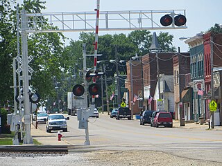
Kangley is a village in LaSalle County, Illinois, United States. The population was 235 at the 2020 census, down from 251 at the 2010 census. It is part of the Ottawa Micropolitan Statistical Area. It is a part of the geographic region known as Streatorland.
LaSalle or La Salle is a city in LaSalle County, Illinois, United States, located at the intersection of Interstates 39 and 80. It is part of the Ottawa, IL Micropolitan Statistical Area. Originally platted in 1837 over one square mile, the city's boundaries have grown to 12 sq mi (31 km2). City boundaries extend from the Illinois River and Illinois and Michigan Canal to a mile north of Interstate 80 and from the city of Peru on the west to the village of North Utica on the east. Starved Rock State Park is located approximately 5 mi (8 km) to the east. The population was 9,582 as of the 2020 census, down from 9,609 at the 2010 census. LaSalle and its twin city, Peru, make up the core of the Illinois Valley. Due to their combined dominance of the zinc processing industry in the early 1900s, they were collectively nicknamed "Zinc City."

Leland is a village in LaSalle County, Illinois, United States. The population was 951 at the 2020 census. It is part of the Ottawa Micropolitan Statistical Area.

Leonore is a village in LaSalle County, Illinois, United States. The population was 121 at the 2020 census. It is part of the Ottawa Micropolitan Statistical Area.

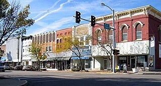
Mendota is a city in LaSalle County, Illinois, United States, in the state's north-central region. The population was 7,061 at the 2020 census. It is part of the Ottawa, IL Micropolitan Statistical Area. Mendota is located approximately 85 miles west of Chicago, 70 miles east of Moline and 55 miles south of Rockford. The current mayor is David W. Boelk, an independent elected to a four-year term.
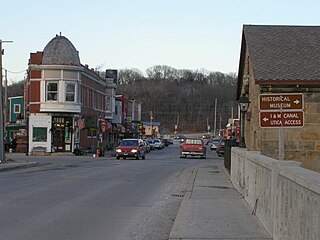
North Utica, often known as Utica, is a village in Utica Township, LaSalle County, Illinois. The population was 1,323 at the 2020 census. It is part of the Ottawa Micropolitan Statistical Area.

Rutland is a village in LaSalle County, Illinois, United States. It is part of the Ottawa Micropolitan Statistical Area. As of the 2020 census, the population was 259, down from 318 at the 2010 census.

Streator is a city in LaSalle and Livingston counties in the U.S. state of Illinois. The city is situated on the Vermilion River approximately 81 miles (130 km) southwest of Chicago in the prairie and farm land of north-central Illinois. As of the 2020 census, the population of Streator was 12,500.

Area codes 815 and 779 are telephone area codes in the North American Numbering Plan (NANP) for most of northern Illinois outside the Chicago and Quad Cities areas. It also serves the Joliet area and some of Chicago’s western and northwestern exurbs. 815 was one of the four original Illinois area codes set up in 1947. Area code 779 was assigned to the same numbering plan area in 2009 to form an overlay.

The South Bend–Mishawaka Metropolitan Statistical Area, sometimes referred to as Michiana, as defined by the United States Census Bureau, is an area consisting of two counties – one in northern Indiana and one in southwest Michigan (Cass), anchored by the cities of South Bend and Mishawaka in Indiana. As of the 2010 census, the MSA had a population of 319,224.
The Kokomo Metropolitan Statistical Area, as defined by the United States Census Bureau, is an area consisting of Howard County in Indiana. Howard County had a population estimate of 83,831 in 2023. Kokomo is also the principal city of the area known as North Central Indiana, the area around Kokomo with economic ties. The six county area including Cass, Clinton, Fulton, Howard, Miami, and Tipton counties had population of 228,331 people in 2010.
Mendota Township High School is a secondary school located at 2300 W. Main Street, Mendota, Illinois. It currently educates, as of August 2010, 619 students. The school lies within School District No. 280, and MHS is the only school that the district operates. The district superintendent is Jeff Prusator who has been serving in that position since 2004. Denise Aughenbaugh is the principal, with Joe Masini serving as vice-principal.
The Tri-County Conference is a high school conference in north central Illinois. The conference participates in athletics and activities in the Illinois High School Association. The conference incorporates 8 small public and 2 small private high schools, with enrollments between 82-428 students in LaSalle, Livingston, Marshall, Putnam, and Woodford counties.


