Pennsylvania Route 120

Last updated

PA-120.svg

Pennsylvania Route 120

PA Route 120 map.svg
Highways in Pennsylvania with PA 120 in red.
Route information
Maintained by PennDOT
Length103.886 mi [1]  (167.188 km)
Existed1926 (as US 120)–present
Tourist
routes
Bucktail Trail Scenic Byway
Major junctions
West endUS 219.svgPA-948.svg US 219  / PA 948 in Ridgway
Major intersectionsPA-255.svg PA 255 in St. Marys

PA-46.svg PA 46 in Emporium
PA-155.svg PA 155 near Emporium
PA-555.svg PA 555 in Driftwood
PA-872.svg PA 872 near Jericho

Contents

PA-144.svg PA 144 in Renovo
East endI-99 (Future).svgUS 220.svg Future I-99  / US 220 near Lock Haven
Location
Country United States
State Pennsylvania
Counties Elk, Cameron, Clinton
Highway system
US 119.svg US 119 PA-121.svg PA 121

Pennsylvania Route 120 (PA 120) is a state highway in the U.S. state of Pennsylvania, running from U.S. Route 219 (US 219) in Ridgway east to US 220 near Lock Haven. [2]

Bucktail State Park Natural Area

PA 120 westbound at PA 872 in Grove Township 2022-06-13 10 08 14 View west along Pennsylvania State Route 120 (Main Street) at Pennsylvania State Route 872 (First Fork Road) in Grove Township, Cameron County, Pennsylvania.jpg
PA 120 westbound at PA 872 in Grove Township
PA 120 in Clinton County, at the western end of Bucktail State Park Natural Area Pennsylvania Route 120, Clinton County.JPG
PA 120 in Clinton County, at the western end of Bucktail State Park Natural Area

In much of Cameron and Clinton counties, PA 120 is a Pennsylvania Scenic Byway designated the Bucktail State Park Natural Area. [3] Bucktail State Park Natural Area runs 75 miles (121 km) from Emporium to Lock Haven, and is named for the Pennsylvania Bucktails Regiment, who came from the area during the American Civil War. PA 120 and the park run along Sinnemahoning Creek and the West Branch Susquehanna River and also pass through Renovo (in Clinton County).

Bucktail State Park Natural Area was established by the Pennsylvania State Legislature in 1933. It includes 21,039 acres (85.14 km2), of which 9,239 acres (37.39 km2) are in Cameron County and 11,800 acres (47.75 km2) in Clinton County. While much of the land is state owned and part of the Elk and Sproul State Forests, there are also many tracts of privately owned land within the official boundaries of the park. The law establishing the park defined its boundaries as "all that area of land extending in length from the western city line of Lock Haven, in Clinton County, to the eastern borough line of Emporium, in The County of Cameron, and along the course of the western branch of the Susquehanna River, and its tributary, Sinnemahoning Creek, in Clinton and Cameron counties, an estimated distance of 75 miles, and in width from mountain rim to mountain rim across the valley." [4] The park is primarily dedicated to wildlife viewing, especially elk.

History

The PA 120 bridge over the West Branch Susquehanna River, as seen from Hyner View State Park in Clinton County PA Route 120 Bridge from Hyner View Autumn.jpg
The PA 120 bridge over the West Branch Susquehanna River, as seen from Hyner View State Park in Clinton County
US 120 in the "final" 1926 plan; it was truncated to Ridgway-Reading in 1927 US120-1926.jpg
US 120 in the "final" 1926 plan; it was truncated to Ridgway-Reading in 1927

PA 120 follows an old Native American Trail, the Sinnemahoning Path. This trail was used by Native Americans to cross the eastern continental divide (specifically the Allegheny Front) between the Susquehanna River (which drains into the Chesapeake Bay) and the Allegheny River (which forms the Ohio River with the Monongahela River at Pittsburgh and eventually drains into the Gulf of Mexico via the Mississippi River). American Pioneers also used the trail to make their way west and it was also known as the Bucktail Trail.

US 120 (1961 cutout).svg

U.S. Route 120

Location Ridgway Lock Haven
Existed1926–1967

PA 120 was U.S. Route 120 until ca. 1967. US 120 was initially planned in 1926 as an EriePhiladelphia route, but was truncated to RidgwayReading in 1927, the route west of Ridgway primarily becoming an extension of US 6 [5] and that to the east of Reading becoming the eastern segment of US 422. [6] The portion east of Lock Haven of the remainder of the route became US 220, US 15, and US 122 ca. 1935; this alignment is now roughly followed by US 220, I-180, PA 147, and PA 61.

Major intersections

CountyLocationmi [1] kmDestinationsNotes
Elk Ridgway 0.0000.000US 219.svgPA-948.svg US 219  / PA 948 (Main Street) Kersey, Brockway, Bradford, Warren Western terminus
0.2350.378North plate.svg
Truck plate.svg
US 219.svg
US 219 Truck north (Osterhaut Street)
Western end of US 219 Truck northbound concurrency
Ridgway Township 1.1831.904Truck plate.svg
US 219.svg
US 219 Truck
Eastern end of US 219 Truck northbound concurrency; US 219 Truck northbound one-way only
St. Marys 10.16316.356South plate.svg
PA-255.svg
PA 255 south (South St. Marys Street) DuBois
Western end of PA 255 concurrency
10.36316.678North plate.svg
PA-255.svg
PA 255 north (North Michael Street) Johnsonburg
Eastern end of PA 255 concurrency
Cameron Emporium 29.14246.900North plate.svg
PA-46.svg
PA 46 north (Woodland Avenue) Smethport
Southern terminus of PA 46
Shippen Township 30.55049.165North plate.svg
PA-155.svg
PA 155 north (Sizerville Road) Port Allegany
Southern terminus of PA 155
Driftwood 47.59776.600West plate.svg
PA-555.svg
PA 555 west (Chestnut Street) Weedville
Eastern terminus of PA 555
Grove Township 51.35582.648North plate.svg
PA-872.svg
PA 872 north (First Fork Road) Austin
Southern terminus of PA 872
Clinton Renovo 73.945119.003North plate.svg
PA-144.svg
PA 144 north (Tamarack Road) Galeton
Western end of PA 144 concurrency
75.503121.510South plate.svg
PA-144.svg
PA 144 south (Birch Street) Moshannon
Eastern end of PA 144 concurrency
Lock Haven 103.073165.880North plate.svg
PA-664.svg
PA 664 north (North Jay Street) / East Water Street Swissdale
Southern terminus of PA 664
103.148166.001South plate.svg
PA-150.svg
PA 150 south (East Main Street) Lock Haven University
One-way pair on PA 150
103.224166.123North plate.svg
PA-150.svg
PA 150 north (East Church Street)
One-way pair on PA 150
103.509–
103.575
166.582–
166.688
Walnut StreetInterchange; no access to westbound PA 120
Castanea Township 103.759–
103.886
166.984–
167.188
US 220.svgTo plate blue.svg
I-80.svg
US 220 (Appalachian Thruway) to I-80  / Jarrett Avenue Milesburg, Williamsport
US 220 exit 111; eastern terminus
1.000 mi = 1.609 km; 1.000 km = 0.621 mi

See also

Related Research Articles

<span class="mw-page-title-main">Cameron County, Pennsylvania</span> County in Pennsylvania, United States

Cameron County is a county in the Commonwealth of Pennsylvania. As of the 2020 census, the population was 4,547, making it Pennsylvania's least populous county. Its county seat is Emporium. The county was created on March 29, 1860, from parts of Clinton, Elk, McKean, and Potter Counties. It is named for Senator Simon Cameron.

<span class="mw-page-title-main">U.S. Route 111</span>

U.S. Route 111 (US 111) was a U.S. Highway that extended from Baltimore, Maryland north to the Harrisburg, Pennsylvania area. It replaced part of the Susquehanna Trail, partially signed as Pennsylvania Route 4, and was in turn replaced by Interstate 83 (I-83). Portions of its pre-freeway alignment are now Maryland Route 45 and I-83 Business. Other old sections in Pennsylvania are now unsigned Quadrant Routes or township-maintained roads. US 111 extended north to the Pennsylvania–New York state line where U.S. Route 15 now crosses it between 1928 and 1937.

<span class="mw-page-title-main">U.S. Route 220</span>

U.S. Route 220 (US 220) is a spur route of US 20. It runs in a north–south layout in the eastern United States, unlike its parent route as well as conventionally even-numbered highways which run east-west. US 220 extends for 678 miles (1,091 km) from an intersection with US 1 in Rockingham, North Carolina, to its interchange with the Southern Tier Expressway in South Waverly, Pennsylvania. Some sections of the route are part of the Appalachian Development Highway System's Corridor O as well as I-73 in North Carolina. US 220 is designated as a spur route of US 20 but the route does not intersect US 20 or connect to other spurs of US 20.

<span class="mw-page-title-main">Elk State Forest</span> State forest in Pennsylvania, United States

Elk State Forest is a Pennsylvania State Forest in Pennsylvania Bureau of Forestry District #13. The main offices are located in Emporium in Cameron County, Pennsylvania.

<span class="mw-page-title-main">Kettle Creek State Park</span> State park in Pennsylvania, United States

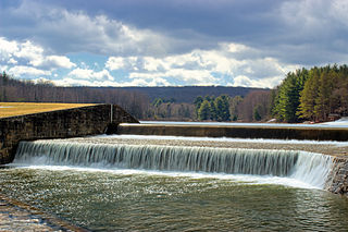
Kettle Creek State Park is a 1,793-acre (726 ha) Pennsylvania state park in Leidy Township, Clinton County, Pennsylvania in the United States. The park is in a valley and is surrounded by mountains and wilderness. It features the Alvin R. Bush Dam built in 1961 by the U.S. Army Corps of Engineers as a flood control measure in the West Branch Susquehanna River basin. Many of the recreational facilities at the park were built during the Great Depression by the young men of the Civilian Conservation Corps. Kettle Creek State Park is seven miles (10 km) north of Westport and Pennsylvania Route 120. It is largely surrounded by Sproul State Forest.

<span class="mw-page-title-main">Sizerville State Park</span> State park near Emporium, Pennsylvania

Sizerville State Park is a 386-acre (156 ha) Pennsylvania state park in Portage Township, Cameron County and Portage Township, Potter County, Pennsylvania in the United States. The park is nearly surrounded by Elk State Forest making it part of one of the largest blocks of state-owned land in Pennsylvania. Sizerville State Park is on Pennsylvania Route 155, six miles (10 km) north of the borough of Emporium.

<span class="mw-page-title-main">Sinnemahoning State Park</span> State park in Cameron and Potter counties, Pennsylvania

Sinnemahoning State Park is a 1,910-acre (773 ha) Pennsylvania state park in Grove Township, Cameron County and Wharton Township, Potter County, Pennsylvania, in the United States. The park is surrounded by Elk State Forest and is mountainous with deep valleys. The park is home to the rarely seen elk and bald eagle. Sinnemahoning State Park is on Pennsylvania Route 872, eight miles (13 km) north of the village of Sinnamahoning. In 1958, the park opened under the direction of the Pennsylvania Bureau of Forestry: it became a Pennsylvania State Park in 1962.

<span class="mw-page-title-main">Bucktail State Park Natural Area</span>

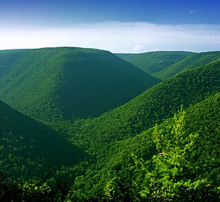
Bucktail State Park Natural Area is a 16,433-acre (6,650 ha) Pennsylvania state park in Cameron and Clinton Counties in Pennsylvania in the United States. The park follows Pennsylvania Route 120 for 75 miles (121 km) between Emporium and Lock Haven. Bucktail State Park Natural Area park runs along Sinnemahoning Creek and the West Branch Susquehanna River and also passes through Renovo. The park is named for the Civil War Pennsylvania Bucktails Regiment and is primarily dedicated to wildlife viewing, especially elk.

<span class="mw-page-title-main">Hyner Run State Park</span> State Park in Pennsylvania, United States

Hyner Run State Park is a 180-acre (73 ha) Pennsylvania state park in Chapman Township, Clinton County, Pennsylvania in the United States. The park is 6 miles (9.7 km) east of Renovo and 3 miles (5 km) north of Hyner on Pennsylvania Route 120. Hyner Run State Park is surrounded by Sproul State Forest.

<span class="mw-page-title-main">Hyner View State Park</span> State park in Pennsylvania, United States

Hyner View State Park is a 6-acre (2.4 ha) Pennsylvania state park in Chapman Township, Clinton County, Pennsylvania in the United States. The park is 6 miles (9.7 km) east of Renovo and 3 miles (4.8 km) north of Hyner on Pennsylvania Route 120. Hyner View State Park is surrounded by Sproul State Forest.

<span class="mw-page-title-main">Parker Dam State Park</span>

Parker Dam State Park is a 968-acre (392 ha) Pennsylvania state park in Huston Township, Clearfield County, Pennsylvania in the United States. The park is surrounded by Moshannon State Forest. Parker Dam State park is 17 miles (27 km) north of Clearfield on Pennsylvania Route 153 just off exit 111 of Interstate 80. The park was constructed during the Great Depression by the Civilian Conservation Corps. They built many of the facilities that are in use today at Parker Dam State Park.

<span class="mw-page-title-main">Pennsylvania Route 155</span> State highway in Pennsylvania, US

Pennsylvania Route 155 is a 32.2-mile-long (51.8 km) state highway located in Cameron, Potter, and McKean counties in Pennsylvania. The southern terminus is at PA 120 in Emporium. The northern terminus is at PA 446 in Eldred Township.

<span class="mw-page-title-main">Pennsylvania Route 555</span> State highway in Pennsylvania, US

Pennsylvania Route 555 is a 26.3-mile-long (42.3 km) state highway located in Elk and Cameron Counties in Pennsylvania. The western terminus is at PA 255 in Jay Township community of Weedville. The eastern terminus is at PA 120 in Driftwood.

<span class="mw-page-title-main">Pennsylvania Route 872</span> State highway in Pennsylvania, US

Pennsylvania Route 872 is a 39.8-mile-long (64.1 km) state highway located in Cameron and Potter counties in Pennsylvania. The southern terminus is at PA 120 in Grove Township. The northern terminus is at U.S. Route 6 /PA 44 in Coudersport.

<span class="mw-page-title-main">U.S. Route 220 in Pennsylvania</span> Section of U.S. Highway in Pennsylvania

U.S. Route 220 is a U.S. Highway that is a spur route of US 20. It runs from Rockingham, North Carolina, north to South Waverly, Pennsylvania. In the state of Pennsylvania, the route runs 248 miles (399 km) from the Maryland border in Cumberland Valley Township, Bedford County northeast to an interchange with Interstate 86 (I-86)/New York State Route 17 in South Waverly, Bradford County a short distance south of the New York border. Through the state, US 220 passes through the cities and towns of Bedford, Altoona, State College, Lock Haven, Williamsport, and Towanda. US 220 is concurrent with the entire completed Pennsylvania segment of I-99 between I-70/I-76 in Bedford and I-80 near Bellefonte. US 220 is also a freeway around Bedford, along the I-80 concurrency between Bellefonte and Mill Hall, between Mill Hall and Jersey Shore, from the western end of Williamsport to near Halls, and near the New York border. The remainder of US 220 in Pennsylvania is mostly a two-lane surface road.

The Bucktail Path is a 33.5-mile (53.9 km) hiking trail in north-central Pennsylvania, through portions of Elk State Forest. Most of the trail is in Cameron County, with its northern end in Potter County. It should not be confused with the scenic highway in the same region known as Bucktail Trail; several features in the region were named after the Bucktail Regiment of local soldiers during the American Civil War. The Bucktail Path is often described as one of the most isolated and least hiked backpacking trails in Pennsylvania, with a path that can be difficult to follow even for experienced hikers; and it has experienced long periods of under-use with little maintenance. It is also known for several challenging climbs and bridgeless stream crossings.

<span class="mw-page-title-main">Donut Hole Trail</span>

The Donut Hole Trail is a 94.2-mile (151.6 km) hiking trail in north-central Pennsylvania, through Sproul State Forest and roughly parallel to the West Branch Susquehanna River. Most of the trail is in Clinton County, with a short segment at its western end in Cameron County. The Donut Hole Trail is regarded as one of the most challenging and remote backpacking trails in Pennsylvania, encountering just six paved roads along its entire length and featuring many difficult climbs and creek crossings.

The Pennsylvania State Game Lands Number 14 are Pennsylvania State Game Lands in Cameron, and Elk Counties in Pennsylvania in the United States providing hunting, bird watching, and other activities.

The Pennsylvania State Game Lands Number 30 are Pennsylvania State Game Lands in McKean County in Pennsylvania in the United States providing hunting, bird watching, and other activities.

References

  1. 1 2 Bureau of Maintenance and Operations (January 2015). Roadway Management System Straight Line Diagrams (Report) (2015 ed.). Pennsylvania Department of Transportation. Archived from the original on February 17, 2011. Retrieved June 30, 2015.
  2. Google (July 24, 2014). "Pennsylvania Route 120" (Map). Google Maps . Google. Retrieved July 24, 2014.
  3. "Bucktail Trail". VisitPA.com. Retrieved March 27, 2012.
  4. "Bucktail State Park". Pennsylvania Department of Conservation and Natural Resources . Retrieved 2007-08-07.
  5. Weingroff, Richard F. "U.S. 6: The Grand Army of the Republic Highway". Federal Highway Administration . Retrieved 2013-01-20.
  6. Weingroff, Richard F. "U.S. 22: The William Penn Highway". Federal Highway Administration . Retrieved 2013-01-20.

Route map:

Template:Attached KML/Pennsylvania Route 120
KML is from Wikidata