Pennsylvania State Route System

Last updated
Pennsylvania State Route System

I-76.svg

US 6.svg

PA-18.svg

PA QR 3069.svg

Route markers for Interstate 76, U.S. Route 6, Pennsylvania Route 18, and State Route 3069
System information
Length41,643 mi [1]  (67,018 km)
NotesNumbers are assigned through Location Referencing System; all routes are assigned quadrant numbers, State Route X (SR X), which usually corresponded to the signed numbers of traffic routes (PA X). Traffic Routes are generally state-maintained.
Highway names
Interstates Interstate X (I-X)
US Highways U.S. Route X (US X)
State Pennsylvania Route X (PA X)
Quadrant Routes:State Route X (SR X)
System links

In the U.S. state of Pennsylvania, state highways are generally maintained by the Pennsylvania Department of Transportation (PennDOT). Each is assigned a four-digit State Route (SR) number in the present Location Referencing System. Traffic Routes are signed as Interstate Highways, U.S. Routes and Pennsylvania Routes (PA Routes), and are prefixed with one to three zeroes to give a four-digit number. PA Routes are also called Pennsylvania Traffic Routes, and formerly State Highway Routes. [2]

Contents

There are 41,643 mi (67,018 km) of roadway maintained by state agencies, with 39,737 mi (63,951 km) maintained by PennDOT, 554 mi (892 km) maintained by the Pennsylvania Turnpike Commission, and 1,352 mi (2,176 km) maintained by other state agencies. [1]

History

The Pennsylvania State Route System was established by the Sproul Road Bill passed in 1911. The system took control of over 4,000 miles of road. The system of roads continued to grow over the next few decades until continual addition of roads faced greater opposition. On October 1, 1940, the Pennsylvania Turnpike's first section of highway was opened to motorized traffic; the Turnpike operated under the Pennsylvania Turnpike Commission and was independent of the then-known Department of Highways.

In 1970, the Department of Highways and several other offices and departments were reorganized into the Pennsylvania Department of Transportation. In 1987, the Sproul system of Legislative Routes was reorganized into the current Pennsylvania State Route System under the Location Referencing System.

In 2013, PennDOT posted weight restrictions on several bridges along the state route system. [3] As a result, several truck routes were signed for U.S. and state routes, bypassing these weight restricted bridges. Signage practices for these truck routes vary by district, with some districts such as District 5 signing them as standard truck routes and others such as District 6 signing them as double-bannered "alternate truck" routes. [3] [4] [5]

Location Referencing System

LRS number assignments [6]
Route numberNameDescription
0001-0999Traffic Routesleading zeroes are often omitted on the markers
1001-4999Quadrant Routesassigned by rough quadrant in the county, going clockwise from northeast (1) to northwest (4)
6001-6999Relocated Traffic Routes(Including alternate lanes such as local lanes or HOV lanes), assigned a number equal to the old number plus 6000
7001-7999Turned back, abandoned, or null routes7076, 7276, 7376, 7576, 7476, 7043, and 7066 are used for sections of the Pennsylvania Turnpike [7]
8001-8999 Interchanges With one number per interchange
9101-9199 Wye connections
9201-9299 Rest areas
9301-9399 Truck escape ramps
9401-9499Other roadwaysIncludes jughandles and truck inspection stations
9501-9599 Park and ride

Signage

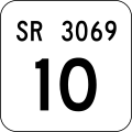
The symbol used for the signage of state routes is an outline of the keystone after Pennsylvania's nickname. Four-digit State Routes are unsigned, except on small white reference markers near physical features such as intersections and bridges, and are only unique within each county. Underneath, there is a larger typeface number identifying the segment of highway being entered. Segments are typically one half mile long and are usually numbered in multiples of 10 on non-Interstate highways. Segment numbers increase in the north or east direction, and are even-numbered on undivided highways and on the northbound or eastbound direction of divided highways. [8]

Circumstances with some routes

Special routes are not assigned State Route numbers corresponding to their signed numbers, but are instead marked along other routes, mostly Quadrant Routes.

Concurrencies are assigned a number equal to the smaller number of the concurrent routes, or the highest type (Quadrant Route → PA Route → U.S. Route → Interstate). [6]

Occasionally, a signed Traffic Route number does not match the State Route, usually in the case of an extension or relocation. (One example is Pennsylvania Route 3, which uses a one-way pair of Quadrant Routes in Center City Philadelphia.) A different number can also be used to avoid conflicts between different types — for instance, signed Pennsylvania Route 380 is actually State Route 400, renumbered ca. 1973 when Interstate 81E was renumbered Interstate 380. The majority of, but not all, signed Traffic Routes are state-maintained. [9]

Lists of routes

I-blank.svg Interstate Highways: A list of interstate highways.
US blank.svg U.S. Routes: A list of U.S. highways.
PA-blank2di.svg State Routes: A list of state routes.

See also

Related Research Articles

<span class="mw-page-title-main">Interstate 99</span> Interstate Highway in Pennsylvania and New York

Interstate 99 (I-99) is an interstate highway in the United States with two segments: one located in central Pennsylvania and the other in southern New York. The southern terminus of the route is near exit 146 of the Pennsylvania Turnpike (I-70/I-76) north of Bedford, where the road continues south as U.S. Route 220 (US 220). The northern terminus of the Pennsylvania segment is at an at-grade intersection with Musser Lane just before reaching I-80 near Bellefonte. The New York segment follows US 15 from the Pennsylvania–New York border to an interchange with I-86 in Corning. Within Pennsylvania, I-99 passes through Altoona and State College—the latter home to the Pennsylvania State University—and is entirely concurrent with US 220. Long-term plans call for the two segments of I-99 to be connected using portions of I-80, US 220, and US 15 through Pennsylvania.

<span class="mw-page-title-main">Interstate 376</span> Highway in Pennsylvania

Interstate 376 (I-376) is a major auxiliary route of the Interstate Highway System in the US state of Pennsylvania, located within the Allegheny Plateau. It runs from I-80 near Sharon south and east to a junction with the Pennsylvania Turnpike in Monroeville, after having crossed the Pennsylvania Turnpike at an interchange in Big Beaver. The route serves Pittsburgh and its surrounding areas and is the main access road to Pittsburgh International Airport (PIT). Portions of the route are known as the Beaver Valley Expressway, Southern Expressway, and Airport Parkway. Within Allegheny County, the route runs along the majority of the Penn-Lincoln Parkway, known locally as Parkway West and Parkway East. It is currently the ninth-longest auxiliary Interstate route in the system and second only to I-476 within Pennsylvania.

<span class="mw-page-title-main">Interstate 476</span> Interstate Highway in Pennsylvania, US

Interstate 476 (I-476) is a 132.1-mile (212.6 km) auxiliary Interstate Highway of I-76 in the U.S. state of Pennsylvania. The highway runs from I-95 near Chester north to I-81 near Scranton, serving as the primary north–south Interstate corridor through eastern Pennsylvania. It consists of both the 20-mile (32 km) Mid-County Expressway, locally referred to as the "Blue Route", through Delaware and Montgomery counties in the suburban Philadelphia area, and the tolled, 110.6-mile (178.0 km) Northeast Extension of the Pennsylvania Turnpike, which connects the Delaware Valley with the Lehigh Valley, the Pocono Mountains, and the Wyoming Valley to the north.

<span class="mw-page-title-main">Schuylkill Expressway</span> Highway in Pennsylvania

The Schuylkill Expressway, locally known as "the Schuylkill", is a freeway through southern Montgomery County and the city of Philadelphia. It is the easternmost segment of Interstate 76 (I-76) in the U.S. state of Pennsylvania. It extends from the Valley Forge interchange of the Pennsylvania Turnpike in King of Prussia, paralleling its namesake Schuylkill River for most of the route, southeast to the Walt Whitman Bridge over the Delaware River in South Philadelphia. It serves as the primary corridor into Philadelphia from points west. Maintenance and planning for most of the highway are administered through Pennsylvania Department of Transportation (PennDOT) District 6, with the Delaware River Port Authority (DRPA) maintaining the approach to the Walt Whitman Bridge.

<span class="mw-page-title-main">Interstate 176</span> Auxiliary Interstate Highway in Berks County, Pennsylvania, United States

Interstate 176 (I-176) is a spur route of eastern I-76 in Berks County, Pennsylvania. I-176, known locally as the Morgantown Expressway, travels from I-76 in Morgantown north to U.S. Route 422 (US 422) in Cumru Township in Berks County, a suburban township just outside the city of Reading; the entire length of the highway is just over 11 miles (18 km). The highway was originally known as Interstate 180 (I-180) or the "Reading Spur" when the Pennsylvania Turnpike was part of I-80S but was redesignated to its present-day number in 1964 when I-80S became I-76.

<span class="mw-page-title-main">Pennsylvania Route 28</span> State highway in Pennsylvania, US

Pennsylvania Route 28 is a major state highway, which runs for 98 miles (158 km) from Anderson Street in Pittsburgh to U.S. Route 219 (US 219) in Brockway in Pennsylvania in the United States.

The Mon–Fayette Expressway is a partially-completed controlled-access toll road that is planned to eventually link Interstate 68 near Morgantown, West Virginia with Interstate 376 near Monroeville, Pennsylvania. The ultimate goal of the highway is to provide a high speed north–south connection between Morgantown and the eastern side of Pittsburgh while revitalizing economically distressed Monongahela River Valley towns in Fayette and Washington counties, serving as an alternative to Interstate 79 to the west, as well as relieving the PA 51 alignment from Pittsburgh to Uniontown.

<span class="mw-page-title-main">Interstate 70 in Pennsylvania</span> Section of Interstate highway in Pennsylvania, United States

Interstate 70 (I-70) is a state highway that is located in the Commonwealth of Pennsylvania in the United States. It runs east to west across the southwest part of Pennsylvania and serves the southern fringe of the Pittsburgh metropolitan area.

<span class="mw-page-title-main">Bethlehem Pike</span>

Bethlehem Pike is a historic 42.21 mi (67.93 km) long road in the U.S. state of Pennsylvania that connects Philadelphia and Bethlehem, Pennsylvania. It began as a Native American path called the Minsi Trail which developed into a colonial highway called the King's Road in the 1760s. Most of the route later became part of U.S. Route 309, now Pennsylvania Route 309.

<span class="mw-page-title-main">Pennsylvania Route 82</span> State highway in Chester County, Pennsylvania, United States

Pennsylvania Route 82 is a 32-mile-long (51 km) north–south state highway located in Chester County in southeast Pennsylvania, USA. The southern terminus is at the Delaware state line southeast of Kennett Square, where the road continues south into that state as Delaware Route 82. The northern terminus is at PA 23 in Elverson. PA 82 heads through rural areas of Chester County along with the communities of Kennett Square, Unionville, and Coatesville. The route intersects many important roads including U.S. Route 1 near Kennett Square, PA 162 and PA 842 in Unionville, US 30 in Coatesville, and US 322 in Brandywine Manor. PA 82 is a two-lane undivided road most of its length.

<span class="mw-page-title-main">State Route 1002 (Lehigh County, Pennsylvania)</span> Highway in Pennsylvania

State Route 1002(SR 1002), locally known as Tilghman Street and Union Boulevard, is a major 13.8 mi (22.2 km) long east–west road in the Lehigh Valley region of eastern Pennsylvania. The majority of the roadway is the former alignment of U.S. Route 22, maintained by the Pennsylvania Department of Transportation as a Quadrant Route, and is not signed except on small white segment markers.

<span class="mw-page-title-main">Interstate 81 in Pennsylvania</span> Section of Interstate Highway in Pennsylvania

Interstate 81 (I-81) is a north–south Interstate Highway, stretching from Dandridge, Tennessee, northeast to Fisher's Landing, New York, at the Canada–United States border. In Pennsylvania, I-81 runs for 232.76 miles (374.59 km) from the Maryland state line northeast to the New York state line near Hallstead and is called the American Legion Memorial Highway. The interstate enters the state near the borough of Greencastle, serving the boroughs of Chambersburg and Carlisle, before reaching Harrisburg, the capital. After that, it climbs into the Pocono Mountains to run through the Wyoming Valley, then exits into New York. It is the longest north–south Interstate in Pennsylvania.

<span class="mw-page-title-main">Pennsylvania Route 152</span> State highway in Pennsylvania, US

Pennsylvania Route 152 (PA 152) is a 25.3-mile-long (40.7 km) state highway located in the U.S. state of Pennsylvania. The route travels north–south from an interchange with PA 309 located in the Cedarbrook neighborhood of Cheltenham Township in Montgomery County north to another interchange with PA 309 located northeast of Telford in Bucks County. PA 152 is known as Limekiln Pike for most of its length. From the southern terminus, the route passes through suburban areas to the north of Philadelphia, serving Dresher, Maple Glen, and Chalfont. North of Chalfont, PA 152 runs through rural suburbs of Philadelphia before reaching Silverdale. Past here, the road continues northwest through Perkasie, where it turns southwest and passes through Sellersville before reaching its northern terminus.

<span class="mw-page-title-main">Pennsylvania Route 867</span> State highway in Pennsylvania, US

Pennsylvania Route 867 is a 12-mile-long (19 km) state highway located in Bedford and Blair counties in Pennsylvania. The southern terminus is at PA 869 in South Woodbury Township. The northern terminus is at PA 36/PA 164 outside of Roaring Spring.

<span class="mw-page-title-main">Pennsylvania Route 903</span> State highway in Pennsylvania, US

Pennsylvania Route 903 is a 17.7-mile-long (28.5 km) state highway located in Carbon and Monroe counties in Pennsylvania. The southern terminus is at U.S. Route 209 in Jim Thorpe. The northern terminus is at PA 115 in Tunkhannock Township. The route runs through rural areas of the Pocono Mountains, with an interchange with the Pennsylvania Turnpike Northeast Extension in Penn Forest Township and a junction with PA 534 in Kidder Township. PA 903 is a two-lane undivided road nearly its entire length, besides the I-476 intersection. The route was designated in 1928 between US 209/US 309 in present-day Jim Thorpe, and a connecting road, now PA 115, south of Blakeslee. The highway was fully paved in the 1930s. Between 2008 and 2015, an E-ZPass-only interchange was constructed with I-476.

<span class="mw-page-title-main">State Route 2005 (Delaware County, Pennsylvania)</span>

State Route 2005 is a major 9.3 mile (15 km) long road, running in a southeast–northwest direction in Delaware County, Pennsylvania. The western terminus is at Pennsylvania Route 320 in Haverford Township, Pennsylvania. Its eastern terminus is at a Cobbs Creek bridge in Darby, Pennsylvania. Past this bridge is State Route 3023, which continues into Philadelphia. SR 2005 is known as Darby Road in Haverford Township, Lansdowne Avenue from U.S. Route 1 to Darby, and Main Street in Darby.

<span class="mw-page-title-main">Special routes of U.S. Route 30</span> Highway system

Several special routes of U.S. Route 30 exist. In order from west to east they are as follows.

<span class="mw-page-title-main">U.S. Route 209</span> Highway in Pennsylvania and New York

U.S. Route 209 (US 209) is a 211.74-mile (340.76 km) long U.S. Highway in the states of Pennsylvania and New York. Although the route is a spur of US 9, US 209 never intersects US 9, coming within five miles of the route and making the short connection via New York State Route 199 (NY 199). The southern terminus of the route is at Pennsylvania Route 147 (PA 147) in Millersburg, Pennsylvania. The northern terminus is at US 9W north of Kingston in Ulster, New York, where the road continues east as NY 199.

<span class="mw-page-title-main">Delaware State Route System</span> Overview of the State Route System of Delaware

The Delaware State Route System consists of roads in the U.S. state of Delaware that are maintained by the Delaware Department of Transportation (DelDOT). The system includes the portions of the Interstate Highway System and United States Numbered Highways system located in the state along with state routes and other roads maintained by DelDOT. All roads maintained by the state are assigned a maintenance road number that is only marked on little white markers at intersections and on auxiliary plates below warning signs approaching intersections. These numbers are only unique in a specific county; some roads can be designated with multiple road numbers, and numbers do not necessarily correspond to the signed Interstate, U.S., or state route numbers. DelDOT maintains a total of 5,386.14 miles (8,668.15 km) of roads, comprising 89 percent of the roads within the state. Some large bridges in the state are maintained by other agencies including the U.S. Army Corps of Engineers and the Delaware River and Bay Authority. Roads in the system include multilane freeways, multilane surface divided highways, and two-lane undivided roads serving urban, suburban, and rural areas. Some of the roads maintained by DelDOT are toll roads, in which motorists must pay to use.

References

  1. 1 2 "PennDOT Fact Book" (PDF). Pennsylvania Department of Transportation. Retrieved October 3, 2019.
  2. Pennsylvania Department of Transportation, Historic Transportation Maps
  3. 1 2 "Risk-Based Bridge Postings - State and Local Bridges" (PDF). Pennsylvania Department of Transportation. October 8, 2013. Retrieved December 18, 2014.
  4. Google (July 26, 2014). "overview of Pennsylvania Route 940 Truck" (Map). Google Maps . Google. Retrieved July 26, 2014.
  5. Google (November 30, 2014). "overview of U.S. Route 13 Alternate Truck" (Map). Google Maps . Google. Retrieved November 30, 2014.
  6. 1 2 Pennsylvania Department of Transportation - "Location Referencing System" (PDF). (2.05  MiB)
  7. "Penndot - Pennsylvania Stateroads 200901". Pennsylvania Department of Transportation . Retrieved 2020-03-19.
  8. Pennsylvania Department of Transportation, SR Segment Signing Guide (PUB 664)
  9. For instance, the Lawrence County map Archived 2011-08-05 at Wikiwix indicates that Pennsylvania Route 551 north of Pulaski, near the north edge of the county is — except for the bridge over Buchanan Creek — locally maintained as Township Route 649. This is confirmed by the VideoLog. A 1990 county map shows that it was once state-maintained all the way as Legislative Route 649.