
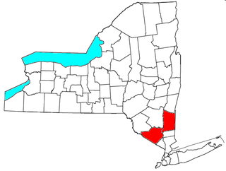
Orange County is a county located in the U.S. state of New York. As of the 2020 census, the population was 401,310. The county seat is Goshen. This county was first created in 1683 and reorganized with its present boundaries in 1798.

Middletown is the largest city in Orange County, New York, United States. It lies in New York's Hudson Valley region, near the Wallkill River and the foothills of the Shawangunk Mountains. Middletown is situated between Port Jervis and Newburgh, New York. At the 2020 United States census, the city's population was 30,345, reflecting an increase of 2,259 from the 28,086 counted in the 2010 census. The zip code is 10940. Middletown falls within the Kiryas Joel–Poughkeepsie–Newburgh Metropolitan Statistical Area, which belongs to the larger New York–Newark–Bridgeport, NY–NJ–CT–PA Combined Statistical Area.

Wallkill is a town in Orange County, New York, United States. The population was 30,486 at the 2020 census. It is centrally located in the county. Interstate 84 crosses New York State Route 17 in the southern part of the town. U.S. Route 6 and New York State routes 17K, 211 and 302 also cross portions of the town.

Shawangunk is a town in southwestern Ulster County, New York, United States. The population was 13,563 at the 2020 census. The town takes its name from its largest stream, the Shawangunk Kill. The name Shawangunk is from the language of the Lenape people. Kill is an abbreviation of the Dutch word for creek, Killitje. It is pronounced Shuh-Whan-Gung

Goshen is a town in Orange County, New York, United States. The population was 14,571 at the 2020 census. The town is named after the Biblical Land of Goshen. It contains a village also called Goshen, which is the county seat of Orange County. The town is centrally located in the county.
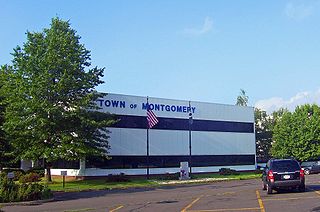
Montgomery is a town in Orange County, New York, United States. Located roughly 60 miles (97 km) northwest of New York City, the town of Montgomery is an historical and cultural hub of the Hudson Valley region and has been a steadily growing outer-ring commuter suburb, in the last 30 years, within the New York metropolitan area. As of the 2020 census, the population was listed as 23,322.

Warwick is a town in the southwestern part of Orange County, New York, United States. Its population was 32,027 at the 2020 census. The town contains three villages and eight hamlets.

The Rockaway River is a tributary of the Passaic River, approximately 35 mi (56 km) long, in Morris County, New Jersey in the United States. The upper course of the river flows through a wooded mountainous valley, whereas the lower course flows through the populated New Jersey suburbs and former industrial area west of New York City. It drains an area of approximately 130 sq mi (340 km²).

The Wallkill River, a tributary of the Hudson, drains Lake Mohawk in Sparta, New Jersey, flowing from there generally northeasterly 88.3 miles (142.1 km) to Rondout Creek in New York, just downstream of Sturgeon Pool, near Rosendale, with the combined flows reaching the Hudson at Kingston.

Papakating Creek is a 20.1-mile-long (32.3 km) tributary of the Wallkill River located in Frankford and Wantage townships in Sussex County, New Jersey in the United States. The creek rises in a small swamp located beneath the eastern face of Kittatinny Mountain in Frankford and its waters join the Wallkill to the east of Sussex borough.

Area codes 845 and 329 are telephone area codes in the North American Numbering Plan (NANP) for the U.S. state of New York. The numbering plan area comprises the mid- and lower Hudson Valley, specifically Orange, Putnam, Rockland, and Ulster counties, and parts of Columbia, Delaware, Dutchess, Greene, and Sullivan counties.
Drowned lands is a name sometimes given to seasonally flooded areas, or to areas flooded by reservoirs. Sometimes it is poetically applied to lands said to have been lost to the sea, such as Lyonesse.
The Orange County Fair is an annual fair held in the town of Wallkill, New York. The fair began when farmers of Orange County organized an agricultural society to help promote a county fair. In 1808 they tried to organize the fair but it did not generate enough local interest. The society tried again in 1818 and held the fair until 1825. It took another sixteen years before county leaders met at the Old Stone Courthouse in Goshen, New York on September 11, 1841, and formed the Orange County Agricultural Society. That meeting was the birth of the Orange County Fair and the first fair was held on November 17, 1841, in Goshen.

Sturgeon Pool is a reservoir near the hamlet of Rifton, in the Town of Esopus in Ulster County, New York.
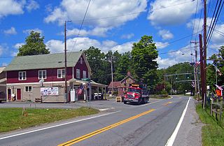
Circleville is a hamlet in the Town of Wallkill, part of Orange County, New York, United States. It is located on NY 302, around the junction with the old Goshen Turnpike, a short distance north of NY 17 and two miles (3 km) south of Bullville. It is three miles (4.8 km) northeast of Middletown.

The Black Dirt Region is located in southern Orange County, New York and northern Sussex County, New Jersey. It is mostly located in the western section of the Town of Warwick, centered on the hamlet of Pine Island. Some sections spill over into adjacent portions of the towns of Chester, Goshen and Wawayanda in New York and parts of Wantage and Vernon, New Jersey. Before the region was drained, around 1880 by the Polish and Volga German immigrants through drainage culverts and the construction of the Delaware and Hudson Canal, it was a densely-vegetated marsh known as the "Drowned Lands of the Wallkill".

Pochuck Mountain is a ridge in the New York-New Jersey Highlands region of the Appalachian Mountains. Pochuck Mountain's summit and most of its peaks lie within Vernon Township, Sussex County, New Jersey, although the south-western portion of the ridge lies within Hardyston Township, and the north-eastern tip of the ridge extends over the New York state line into Orange County. The ridge marks the eastern edge of the Great Appalachian Valley, and it divides the watersheds of the Wallkill River and its tributary Pochuck Creek. The two rivers meet at Pochuck Neck, marking the terminus of the ridge.
The Kiryas Joel-Poughkeepsie-Newburgh, NY Metropolitan Statistical Area, as defined by the United States Office of Management and Budget, is an area consisting of two counties in New York's Hudson Valley, with the municipalities of Kiryas Joel, Poughkeepsie, and Newburgh as its principal cities. As of the 2020 census, the MSA had a population of 679,221. The area was centered on the urban area of Poughkeepsie-Newburgh. Prior to July 2023, it was known as the Poughkeepsie-Newburgh-Middletown, NY Metropolitan Statistical Area; whereupon it was renamed to its current name, to reflect population changes among its largest municipalities.
Vincent W. Kosuga was an American onion farmer and commodity trader best known for manipulating the onion futures market. Public outcry over his practices led to the passing of the Onion Futures Act, which banned the trading of futures contracts on onions.

The Effects of Hurricane Irene in New York were the worst from a hurricane since Hurricane Agnes in 1972. Hurricane Irene formed from a tropical wave on August 21, 2011 in the tropical Atlantic Ocean. It moved west-northwestward, and within an environment of light wind shear and warm waters. Shortly before becoming a hurricane, Irene struck Puerto Rico as a tropical storm. Thereafter, it steadily strengthened to reach peak winds of 120 mph (190 km/h) on August 24. Irene then gradually weakened and made landfall on the Outer Banks of North Carolina with winds of 85 mph (137 km/h) on August 27. It slowly weakened over land and re-emerged into the Atlantic on the following day. Later on August 28, Irene was downgraded to a tropical storm and made two additional landfalls, one in New Jersey and another in New York. The storm quickly began to lose tropical characteristics and became extratropical in Vermont.


