Wawayanda, New York

Last updated

Wawayanda, New York
Town of Wawayanda
Wawayanda, NY, town hall.jpg
Wawayanda Town Hall, located on U.S. Route 6
Orange County New York incorporated and unincorporated areas Wawayanda highlighted.svg
Location in Orange County and the state of New York.
USA New York location map.svg
Red pog.svg
Wawayanda, New York
Location within the state of New York
Coordinates: 41°23′36″N74°27′24″W / 41.39333°N 74.45667°W / 41.39333; -74.45667
Country United States
State New York
County Orange
Area
[1]
  Total35.03 sq mi (90.72 km2)
  Land34.72 sq mi (89.92 km2)
  Water0.31 sq mi (0.80 km2)
Elevation
558 ft (170 m)
Population
 (2020)
  Total7,534
  Density216.99/sq mi (83.79/km2)
Time zone UTC-5 (Eastern (EST))
  Summer (DST) UTC-4 (EDT)
FIPS code 36-78839 [2]
GNIS feature ID0979610 [3]
Website Town website

Wawayanda is a town in Orange County, New York, United States. The population was 7,534 as recorded by the 2020 census. The town of Wawayanda is in the western part of the county, south of Middletown.

Contents

History

The town of Wawayanda was established in 1849 from the town of Minisink. It had been first settled after the American Revolution. The name Wawayanda had historically been more broadly used to describe the region, even earlier than a 1769 map, [4] which also shows the line of partition used to resolve the 50-years long New York – New Jersey Line War.

Geography

According to the United States Census Bureau, the town has a total area of 35.0 square miles (91 km2), of which nearly 35.0 square miles (91 km2) is land and 0.1 square miles (0.26 km2) (0.14%) is water.

The town is bordered on the north by the city of Middletown and the town of Wallkill, east by the town of Goshen, south by the town of Warwick, southwest by the town of Minisink, west by the town of Greenville, with a very short shared border with the town of Mount Hope to the northwest.

Interstate 84 and U.S. Route 6 (US 6, the Grand Army of the Republic Highway) are important east-west highways. New York State Route 17M (NY 17M) crosses the northern part of the town. NY 284 is a north-south highway.

Demographics

Historical population
CensusPop.Note
1860 2,085
1870 1,900−8.9%
1880 1,879−1.1%
1890 1,625−13.5%
1900 1,539−5.3%
1910 1,6034.2%
1920 1,6895.4%
1930 1,94615.2%
1940 2,21814.0%
1950 2,4359.8%
1960 3,22932.6%
1970 3,4085.5%
1980 4,29826.1%
1990 5,51828.4%
2000 6,27313.7%
2010 7,26615.8%
2020 7,5343.7%
U.S. Decennial Census [5]

As of the 2010 census, the population was 7,266. The racial makeup was 80.7% white, 12.2% Hispanic, 5.0% African-American, 1.9% Asian, and 0.2% Native American.

As of the census [2] of 2000, there were 6,273 people, 2,095 households, and 1,719 families residing in the town. The population density was 179.3 inhabitants per square mile (69.2/km2). There were 2,174 housing units at an average density of 62.1 per square mile (24.0/km2). The racial makeup of the town was 92.86% white, 1.75% African American, 0.37% Native American, 1.61% Asian, 0.02% Pacific Islander, 1.90% from other races, and 1.50% from two or more races. Hispanic or Latino of any race were 5.88% of the population.

There were 2,095 households, out of which 43.2% had children under the age of 18 living with them, 68.7% were married couples living together, 9.5% had a female householder with no husband present, and 17.9% were non-families. 14.6% of all households were made up of individuals, and 5.5% had someone living alone who was 65 years of age or older. The average household size was 2.98 and the average family size was 3.29.

In the town, the population was spread out, with 29.5% under the age of 18, 6.1% from 18 to 24, 30.1% from 25 to 44, 24.7% from 45 to 64, and 9.5% who were 65 years of age or older. The median age was 37 years. For every 100 females, there were 100.6 males. For every 100 females age 18 and over, there were 96.4 males.

The median income for a household in the town was $61,885, and the median income for a family was $67,479. Males had a median income of $42,491 versus $27,993 for females. The per capita income for the town was $21,856. About 2.8% of families and 3.7% of the population were below the poverty line, including 2.0% of those under age 18 and 4.3% of those age 65 or over.

Hamlets of Wawayanda

Former town supervisors

Denise Quinn, (2020- ), Republican

John Razzano, (2006-2020), Republican

Wayne Skinner, (2004–2006), Democrat

Thomas Deblock, (1996–2004), Republican

Jeffrey K. Bridges Jr., (1992–1996), Republican

Ed. Flynn, (1988–1992), Democrat

Brice "Buzzy" Flynn, (1970–1988), Democrat

See also

Related Research Articles

Burns is a town in Allegany County, New York, United States. The population was 1,045 at the 2020 census. The town is named after Scots poet Robert Burns.

<span class="mw-page-title-main">Centerville, New York</span> Town in New York, United States

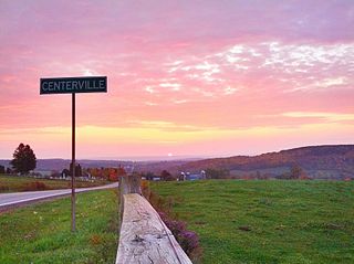
Centerville is a town in Allegany County, New York, United States. The population was 822 at the 2010 census. The town is in the northwest corner of Allegany County and is named after its principal settlement.

Grove is a town in Allegany County, New York, United States. The population was 497 at the 2020 census. Grove is in the northeast part of Allegany County, northwest of Hornell.

Freedom is a town in Cattaraugus County, New York, United States. The population was 2,244 at the 2021 census. The town is in the northeast corner of Cattaraugus County.

<span class="mw-page-title-main">Locke, New York</span> Town in New York, United States

Locke is a town in Cayuga County, New York, United States. The population was 1,877 at the 2020 census. The town was named after John Locke, an English philosopher, and is the birthplace of Millard Fillmore, 13th President of the United States.

Harpersfield is a town in Delaware County, New York, United States. The population was 1,442 at the 2020 census. The town is on the northern border of the county.

<span class="mw-page-title-main">Hillside Lake, New York</span> Census-designated place in New York, United States

Hillside Lake is a hamlet and census-designated place (CDP) in Dutchess County, New York, United States. The population was 1,084 at the 2010 census. It is part of the Poughkeepsie–Newburgh–Middletown, NY Metropolitan Statistical Area as well as the larger New York–Newark–Bridgeport, NY-NJ-CT-PA Combined Statistical Area.

<span class="mw-page-title-main">Westmoreland, New York</span> Town in New York, United States

Westmoreland is a town in Oneida County, New York, United States. The population was 6,138 at the 2010 census.

Bristol is a town in Ontario County, New York, United States. The population was 2,298 at the 2020 census. Bristol was named after Bristol County, Massachusetts, by settlers from New England. The town of Bristol is in the western half of the county, southwest of the city of Canandaigua.

<span class="mw-page-title-main">Deerpark, New York</span> Town in New York, United States

Deerpark is a town in the western part of Orange County, New York, United States, and part of the New York metropolitan area. As of the 2020 Census, the population was at 7,509. The center of population of New York is located in Cuddebackville, a hamlet in Deerpark. Cuddebackville and Deerpark most prominently serve as the headquarters of both the global Falun Gong religious movement and the Shen Yun performance arts troupe, based at the Dragon Springs compound.

<span class="mw-page-title-main">Greenville, Orange County, New York</span> Town in New York, United States

Greenville is a town in Orange County, New York, United States, located along the southern county and state line. The population was 4,689 at the 2020 census.

<span class="mw-page-title-main">Minisink, New York</span> Town in New York, United States

Minisink is a town located in southwestern Orange County, New York, United States, northeast of the New Jersey border between the Town of Greenville and the Town of Warwick. The population was 4,621 at the 2020 census. The town is located near Interstate 84 and New York State Route 17 and lies approximately halfway between New York City and Scranton, Pennsylvania.

<span class="mw-page-title-main">Wallkill, Orange County, New York</span> Town in New York, United States

Wallkill is a town in Orange County, New York, United States. The population was 30,486 at the 2020 census. It is centrally located in the county. Interstate 84 crosses New York State Route 17 in the southern part of the town. U.S. Route 6 and New York State routes 17K, 211 and 302 also cross portions of the town.

<span class="mw-page-title-main">Eastport, New York</span> Hamlet and census-designated place in New York, United States

Eastport is a hamlet and census-designated place (CDP) in Suffolk County, New York, on the South Shore of Long Island. The population was 1,831 at the 2010 census.

<span class="mw-page-title-main">Highland, Sullivan County, New York</span> Town in New York, United States

Highland is a town in Sullivan County, New York, United States. The population was 2,196 at the 2020 census. The town's name denotes its location on elevated ground north of the Delaware River. The town is in the southwestern part of the county.

<span class="mw-page-title-main">Caroline, New York</span> Town in New York, United States

Caroline is a town in Tompkins County, New York, United States. The population was 3,282 at the 2010 census.

<span class="mw-page-title-main">Denning, New York</span> Town in New York, United States

Denning is an isolated town in Ulster County, New York, United States. The population was 493 at the 2020 census. The town is named after an early landowner, William Denning. Denning is located in the western part of the county, deep inside the Catskill Mountains. The location of the town in the Catskill State Park accounts in part for its low population.

<span class="mw-page-title-main">Lloyd, New York</span> Town in New York, United States

Lloyd is a town in Ulster County, New York, United States. The population was 11,133 at the 2020 census. It is part of the New York City combined statistical area.

<span class="mw-page-title-main">Eagle, New York</span> Town in New York, United States

Eagle is an incorporated town in Wyoming County, New York. The population was 1,194 at the 2000 census. The town is on the south border of the county.

<span class="mw-page-title-main">Mooers, New York</span> Town in New York, United States

Mooers is a town in Clinton County, New York, United States. The population was 3,592 at the 2010 census. The town is named after Benjamin Mooers, an early settler.

References

  1. "2016 U.S. Gazetteer Files". United States Census Bureau. Retrieved July 5, 2017.
  2. 1 2 "U.S. Census website". United States Census Bureau . Retrieved January 31, 2008.
  3. "US Board on Geographic Names". United States Geological Survey. October 25, 2007. Retrieved January 31, 2008.
  4. Minisink Valley Genealogy: "The Fork or Branch at the Mouth of Mahacamack...1769". Accessed April 3, 2022.
  5. "Census of Population and Housing". Census.gov. Retrieved June 4, 2015.