Pittstown, New York

Last updated

Pittstown, New York
Rensselaer County New York incorporated and unincorporated areas Pittstown highlighted.svg
Location in Rensselaer County and the state of New York.
Coordinates: 42°53′N73°30′W / 42.883°N 73.500°W / 42.883; -73.500
Country United States
State New York
County Rensselaer
Area
[1]
  Total64.84 sq mi (167.94 km2)
  Land61.63 sq mi (159.62 km2)
  Water3.22 sq mi (8.33 km2)
Elevation
679 ft (207 m)
Population
 (2020)
  Total5,540
  Density85/sq mi (33/km2)
Time zone UTC-5 (Eastern (EST))
  Summer (DST) UTC-4 (EDT)
FIPS code 36-58398
GNIS feature ID0979373

Pittstown is a town in Rensselaer County, New York, United States. The population was 5,540 at the 2020 census. [2] It is in the northern part of the county.

Contents

A small part of the northern town line is Rensselaer County's border with Washington County. Moving west, the Hoosic River defines the town's northwestern line to the crux of its border with the town of Schaghticoke, which juts south to form the western town line. The towns of Brunswick and Grafton border to the southwest and southeast, respectively, with the town of Hoosick to the east.

The majority of the town is served by the Hoosic Valley Central School District, while the southern part of the town is serviced by Brunswick (Brittonkill) Central School District, with a portion of the eastern part of the town served by the Hoosick Falls Central School District.

History

The town is one of the original towns in the county and was created in 1788, from a patent dated 1761.

The Coletti–Rowland–Agan Farmstead, Howard–Odmin–Sherman Farmstead, and Tomhannock Methodist Episcopal Church are listed on the National Register of Historic Places. [3] [4] [5]

Geography

New York State Route 67 runs along the Hoosic River, which defines the northeast town line.

In western Pittstown, a manmade body of water, the Tomhannock Reservoir, provides water to the residents of the city of Troy.

The Pittstown State Forest [6] is in the southeast corner of the town, where New York State Route 7 runs along the northern edge of the Rensselaer Plateau.

According to the United States Census Bureau, the town has a total area of 64.8 square miles (168 km2), of which, 61.7 square miles (160 km2) of it is land (95.2%) and 3.1 square miles (8.0 km2) of it is water (4.8%).

Demographics

Historical population
CensusPop.Note
1820 3,772
1830 3,702−1.9%
1840 3,7842.2%
1850 3,732−1.4%
1860 3,8262.5%
1870 4,0937.0%
1880 4,0950.0%
1890 4,056−1.0%
1900 3,236−20.2%
1910 2,920−9.8%
1920 2,342−19.8%
1930 2,4263.6%
1940 2,4912.7%
1950 2,6667.0%
1960 2,97311.5%
1970 3,90531.3%
1980 4,90125.5%
1990 5,46811.6%
2000 5,6443.2%
2010 5,7351.6%
2020 5,540−3.4%
U.S. Decennial Census [7] [8]

As of the census [9] of 2000, there were 5,644 people, 1,993 households, and 1,548 families residing in the town. The population density was 91.4 inhabitants per square mile (35.3/km2). There were 2,142 housing units at an average density of 34.7 per square mile (13.4/km2). The racial makeup of the town was 97.84% White, 0.48% African American, 0.44% Native American, 0.30% Asian, 0.16% from other races, and 0.78% from two or more races. Hispanic or Latino of any race were 0.66% of the population.

There were 1,993 households, out of which 39.6% had children under the age of 18 living with them, 63.4% were married couples living together, 9.0% had a female householder with no husband present, and 22.3% were non-families. 17.1% of all households were made up of individuals, and 6.4% had someone living alone who was 65 years of age or older. The average household size was 2.83 and the average family size was 3.20.

In the town, the population was spread out, with 28.8% under the age of 18, 7.3% from 18 to 24, 30.5% from 25 to 44, 23.8% from 45 to 64, and 9.5% who were 65 years of age or older. The median age was 36 years. For every 100 females, there were 100.4 males. For every 100 females age 18 and over, there were 100.4 males.

The median income for a household in the town was $49,968, and the median income for a family was $52,194. Males had a median income of $35,173 versus $28,720 for females. The per capita income for the town was $18,578. About 4.3% of families and 6.0% of the population were below the poverty line, including 7.7% of those under age 18 and 9.2% of those age 65 or over.

Communities and locations in Pittstown

Related Research Articles

Wilna is a town in Jefferson County, New York, United States. The population was 5,732 at the 2020 census. The town is on the eastern side of the county and is east of Watertown.

<span class="mw-page-title-main">Berlin, New York</span> Town in New York, United States

Berlin is a town in Rensselaer County, New York, United States. The population was 1,808 at the 2020 census. The town is named after Berlin in Germany, although natives pronounce the name differently, with the accent on the first syllable.

<span class="mw-page-title-main">Grafton, New York</span> Town in New York, United States

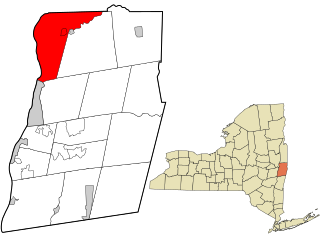
Grafton is a town in Rensselaer County, New York, United States. The population was 2,051 at the 2020 census. It is believed that the town received its name from Grafton, Vermont, where the first town supervisor, Nathaniel Dumbleton, was originally from. The town is an interior town near the north-central part of the county. NY Route 2 passes across the town.

<span class="mw-page-title-main">Hoosick, New York</span> Town in New York, United States

Hoosick is a town in Rensselaer County, New York, United States. The population was 6,711 at the 2020 census. It was named from the Hoosic River.

<span class="mw-page-title-main">Petersburgh, New York</span> Town in New York, United States

Petersburgh is a town located in the northeast section of Rensselaer County, New York, United States. The population was 1,372 at the 2020 census. The town was named after an early settler named Peter Simmons.

<span class="mw-page-title-main">Stephentown, New York</span> Town in New York, United States

Stephentown is a town in Rensselaer County, New York, United States. The population was 2,791 at the 2020 census. The town, which was originally Jericho Hallow in the Massachusetts Bay Colony, was renamed for Stephen Van Rensselaer. The town is located in the southeastern corner of the county, and has a sign proclaiming it to be the only Stephentown on Earth.

<span class="mw-page-title-main">Valley Falls, New York</span> Village in New York, United States

Valley Falls is a village in Rensselaer County, New York, United States. The population was 466 at the 2010 census. The village lies on the boundary of the towns of Pittstown and Schaghticoke, but is mostly in the northwestern part of Pittstown.

<span class="mw-page-title-main">Hadley, New York</span> Town in New York, United States

Hadley is a town in Saratoga County, New York, United States. The population was 1,971 at the 2000 census. The town was named after Hadley, Massachusetts.

<span class="mw-page-title-main">Carlisle, New York</span> Town in New York, United States

Carlisle is a town in northern Schoharie County, New York, United States. The population was 1,768 at the 2020 census.

<span class="mw-page-title-main">Seward, New York</span> Town in New York, United States

Seward is a town in Schoharie County, New York, United States. The population was 1,583 at the 2020 census. The town is named after senator, governor, and secretary of state William H. Seward.

<span class="mw-page-title-main">Olive, New York</span> Town in New York, United States

Olive is a town in Ulster County, New York, United States. The town is west of Kingston, New York, and is inside the Catskill Park. The population was 4,226 at the 2020 census.

<span class="mw-page-title-main">Wawarsing, New York</span> Town in New York, United States

Wawarsing is a town in Ulster County, New York, United States. The population was 12,771 at the 2020 census. The name Wawarsing was once believed to mean "a place where the streams wind" in the Lenape language, referring to the geography in the hamlet of Wawarsing. Specifically, the joining of the Ver Nooy Kill and the Rondout Creek at Port Ben. The name Wawarsing was used by the Lenape to designate the current hamlet and the fields to the north and south of it for at least six miles in both directions. It is the only Lenape name known to refer to an exact location in Ulster County.

<span class="mw-page-title-main">Johnsburg, New York</span> Town in New York, United States

Johnsburg is a town in the northwestern corner of Warren County, New York, United States. It is part of the Glens Falls Metropolitan Statistical Area. The town population was 2,143 at the 2020 census. The town is named after John Thurman, an early settler and founder. Johnsburg is the largest town in Warren County by area.

<span class="mw-page-title-main">Easton, New York</span> Town in New York, United States

Easton is a town in southwestern Washington County, New York, United States along the county's western boundary. It is part of the Glens Falls Metropolitan Statistical Area. The town population was 2,279 at the 2020 census. The town adopted English as its official language on July 6, 2010.

<span class="mw-page-title-main">Schaghticoke, New York</span> Town in New York, United States

SchaghticokeSKAT-i-kohk is a town in Rensselaer County, New York, United States. The population was 7,445 at the 2020 census. It was named for the Schaghticoke, a Native American tribe formed in the seventeenth century from an amalgamation of remnant peoples of eastern New York and New England. The tribe has one of the oldest reservations in the United States, located in what is now Litchfield County, Connecticut. It has been recognized by the state of Connecticut but has not yet achieved federal recognition.

<span class="mw-page-title-main">Milton, Saratoga County, New York</span> Town in New York, United States

Milton is a town in Saratoga County, New York, United States. The population was 18,800 at the 2020 census. Some believe that the town was named after the poet, John Milton, while other sources state that it is a shortening of "Mill-town" for the early mill activity.

<span class="mw-page-title-main">Salem, New York</span> Town in New York, United States

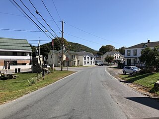
Salem is a town in eastern Washington County, New York, United States. It is part of the Glens Falls Metropolitan Statistical Area. The town population was 2,612 at the 2020 census. The town of Salem contains a hamlet also named Salem, formerly an incorporated village.

Deposit is a town in Delaware County, New York, United States. As of the 2020 census, the town's population was 1,427.

<span class="mw-page-title-main">Plattekill, New York</span> Place in New York, United States

Plattekill is a town in Ulster County, New York, United States. The population was 10,424 in 2020, a slight decrease from 10,499 at the 2010 census. The name is derived from a stream, the Platte Kill.

<span class="mw-page-title-main">Cambridge, New York</span> Town in New York, United States

Cambridge is a town in Washington County, New York, United States. It is part of the Glens Falls Metropolitan Statistical Area. The town population was 1,952 at the 2020 census.

References

  1. "2016 U.S. Gazetteer Files". United States Census Bureau. Retrieved July 5, 2017.
  2. U.S. Census Bureau, 2020 census results, Pittstown, New York. https://www.census.gov/search-results.html?searchType=web&cssp=SERP&q=Pittstown%20town,%20Rensselaer%20County,%20New%20York
  3. "National Register of Historic Places Listings". Weekly List of Actions Taken on Properties: 8/23/13 through 8/30/13. National Park Service. September 6, 2013.
  4. "National Register of Historic Places Listings". Weekly List of Actions Taken on Properties: 4/07/14 through 4/11/14. National Park Service. April 18, 2014.
  5. "National Register of Historic Places Listings". Weekly List of Actions Taken on Properties: 5/26/14 through 5/30/14. National Park Service. June 6, 2014.
  6. "Capital Region/ Northern Catskills - Region 4 - NYS Dept. Of Environmental Conservation".
  7. "Census of Population and Housing". Census.gov. Retrieved June 4, 2015.
  8. U.S. Census Bureau, 2020 census results, Pittstown, New York. https://www.census.gov/search-results.html?searchType=web&cssp=SERP&q=Pittstown%20town,%20Rensselaer%20County,%20New%20York
  9. "U.S. Census website". United States Census Bureau . Retrieved January 31, 2008.
  10. University of the State of New York Bulletin. University of the State of New York. 1914. p. 54.

Further reading

42°50′N73°30′W / 42.833°N 73.500°W / 42.833; -73.500