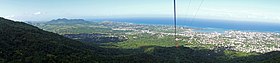
Puerto Plata, officially known as San Felipe de Puerto Plata; (French: Port-de-Plate)[4] is a major coastal city in the Dominican Republic, and capital of the province of Puerto Plata.[5] The city is a major trading port. Puerto Plata has resorts such as Playa Dorada and Costa Dorada, which are located east of the city proper. There are 100,000 hotel beds in the city. The first aerial tramway of the Caribbean is located in Puerto Plata, in which visitors can ride up to the Pico Isabel de Torres, a 793-meter (2600-foot) high mountain within the city.
The city’s history dates back to the early 16th century, when Spanish colonists founded a small colonial settlement in the region. During the first decades of the existence of the Captaincy General of Santo Domingo, the settlement was considered the main commercial and maritime port of the island. In 1605, it was depopulated and destroyed by order of Philip III of Spain to counter raids by English privateers and pirates; a hundred years later, the city was repopulated with farmers from the Canary Islands. From 1822 to 1844 the city was under Haitian control. From 1844 on began the period of the republic, in which the city began to recover its maritime and commercial boom. Beginning in 1865, the current Puerto Plata began to be built. This explains the Victorian style of much of its current architecture. By the end of the 19th century, Puerto Plata had become important for its cultural, social, maritime, and economic development.
Geography
View of Puerto PlataTramway of Puerto Plata
The city sits on land that rises abruptly from the sea making it almost completely visible from the port. It is bordered on the north by the Atlantic Ocean and to the south and southwest by the hill Isabel de Torres.
The small bay around which the city was built provides a natural harbor. Puerto Plata is the largest city on the northern seaboard. Its subdivisions include: El Cupey, Maimón, Los Mameyes, Sabana Grande, El Toro, Tubagua and Yásica. The mountain Isabel de Torres is situated some 5km to the southwest of the city of San Felipe. Geographically it forms part of the Cordillera Septentrional, reaching a maximum height of 800 m above sea level. It is possible to drive to the top of the mountain by following the highway Don José Ginebra. The highway, upon leaving the city, continues west, passing the populated areas of San Marcos, Piedra Candela and El Cruce, arriving at a paved section that continues southeast and then leads directly to the top. The area surrounding Loma Isabel de Torres has been declared a National Monument with an area that covers approximately 20km2. At the summit there is a tropical botanical garden covering about 7 acres (28,000m2), featuring 600 varieties of tropical plants.
Hydrography
The most significant rivers are Camú del Norte, San Marcos, Corozo, Muñoz, Maimón, El Violón, San Piñez, Río Seco, as well as the streams Fú, Blanco, Caballo, Culebra and San Cristóbal.
Climate
Puerto Plata has a tropical climate, more specifically a tropical monsoon climate, with hot, somewhat wet summers and warm, very wet winters (Köppen climate classificationAm), due to its tropical location and the cold fronts that reach the region during the "winter" which typically brings the area humid, wetter weather.
In 1508, Serrano and Diego Nicuëza were sent to the Spanish court to beg the king to treat their cities as the cities in their home country. On December 6, 1508 the Spanish king granted the cities of Hispaniola their seal and their rights. For "Puerto de Plata", as it was called in those years, it was described as follows:
A silver shield with a green mountain, on it was also a golden F and Y crowned and on the top of this, silver and blue. The initials are for the King and Queen of the Spanish Empire, the Catholic Monarchs Fernando and Ysabel (now usually "Isabel").
Since the founding of La Isabela, the first village in the New World, on January 2, 1494, Puerto Plata has been a town of firsts in the Americas.[8] Historians are not clear on the exact year of Puerto Plata's founding. Emilio Rodríguez Demorizi, Américo Lugo, Jose Bordonada, and Samuel Hazard give the year 1502 as recorded by Nicolás of Ovando. Dr. Llenas affirmed that it was 1503. Dr. Joaquín Marino Incháustegui, in his Dominican history records, cites 1504. Dr. Manuel Arturo Roca Batlle indicates that the city was founded in 1505. The historians Alonso Rodriguez Demorizi (brother of Emilio) and Jacinto Gimbernard assert that it was in the year 1496, and Padre Español said it was in 1506.
Christopher Columbus, in his first trip, called the mountain Monte de Plata, observing that since the top is frequently foggy it had a silver-like appearance, hence the name of the port. The city was designed by the brothers Christopher and Bartolomé Columbus, in 1496. The aforementioned Nicolás de Ovando recorded a port existing in the northern coast of the island about 1502. In its first phase as a Spanish colony the town was considered the main commercial and maritime port of the island. Around 1555, Puerto Plata's importance as a port town was lost and it became one of the places of the Antilles frequented by pirates. In 1605 it was depopulated and destroyed by order of Philip III of Spain to counter raids by English privateers and pirates.
A hundred years later, the town was repopulated with farmers originating from the Canary Islands. During the Battle of Puerto Plata Harbor, the United States Marine Corps landed on the island and attacked a French ship and Fortaleza San Felipe. After capturing the French privateer Sandwich and spiking the guns at the fort, the Americans retired victorious. This was during the Quasi-War, an undeclared conflict between France and the United States from 1798 to 1800. From 1822 to 1844 the city was under Haitian control. From 1844 on began the period of the republic, in which the city began to recover its maritime and commercial boom.
The city grew under the influence of European immigrants, who left a cultural and social footprint that remains unique among other cities on the island. In 1863, during the Dominican Restoration War, the city was razed completely. Beginning in 1865, the current Puerto Plata began to be built, explaining the Victorian style of much of its current architecture. By the end of the 19th century, Puerto Plata had become important for its cultural, social, maritime, and economic development. In 1996, Birgenair Flight 301 crashed near Puerto Plata, killing all 189 people on board.[9]
Economy
Puerto Plata, Dominican Republic streets.
The Municipality of San Felipe de Puerto Plata is prominent in agribusiness and tourism, making it a major contributor to the economic growth of the entire country.[citation needed] Other forms of income and economic development that serve to support some segments of the population include port management, sea vessel production, fishing, and textiles. The port has a significant impact in the national and provincial economy.[citation needed]
The port receives cruise ships[10] as well as general bulk freighters which export a variety of merchandise, including farm products and manufactured products in the duty-free zones of the region. A new cruise terminal, closer to the city than Carnival's Amber Cove, is planned: Taino Bay, the new terminal is opened in December 2021.[11]
Culture
Puerto Plata in 1900.
The reports on the celebration of the carnival in the Puerto Plata date from the end of the 19th century. The central personage is the devil cojuelo, that in Puerto Plata becomes Taimáscaro, that produces deities Taínas in its masks, and a suit where elements of Spanish and culture are symbolized and the African essences, in multicolored tapes in its arms, and all that is complemented with the conches of the Atlantic Ocean, as natural elements of identity of the town Puertoplateño.[citation needed]
These festivities are celebrated during the months of February and March, in the avenue of the Jetty and the streets of the city. The people are entertained by the parades of disguises, the music, the popular dances, and the different demonstrations of the arts reflecting cultural identity. Each year the organizers of the carnival choose the King Momo, representing the city that has fought to maintain its traditions.
Architecture
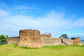
The city of Puerto Plata is characterized by its dominant Victorian style architecture, combined with various other architectural styles, giving a varied character to the process of urban development. Inside this variety is the old style related to the colonial epoch, of which remains as an example the Fortress San Felipe.
Another it is the traditional style, originated when the city was founded by migrant canarios, and of the one that the balconies are inherited, and as an example is the bridge of the Guinea, of the year 1879. Then developed the Victorian model, because of the French, Italian, German, and English immigration, and from other European countries, which began after the Dominican Restoration War and had its height at the end of the 19th century and start of the 20th. This style was utilized in dwellings and in buildings destined for social activities. This type of construction gives its own image to the province.
Finally, Puerto Plata developed a modern architecture because of the American occupation (1916 and 1924), and continuing under Trujillo, based on cement block construction.
Downtown Puerto Plata
Education
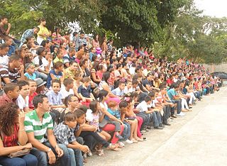
People in parade of Puerto Plata city, Dominican Republic.
Some of the illustrioups educators who left a mark in the Puerto Plata education system include Antera Mota, Emilio Prud'Homme, Ana Isabel Jiménez, Mercedes Mota, José Dubeau, Doña Isabel Díaz-Alejo y Reyes, Doña Elvia Campillo, Isabel Meyreles, María Concepción Gómez Matos, among others. Currently, the municipality of San Felipe of Puerto Plata counts on 182 educational centers, of which the 67% correspond to the public sector and 39% to the private sector.
This municipality has a total of 29,279 students, of whom 1,567 are at the initial level, 19,395 at the basic level, 6,642 at the medium level, 1,505 students to the subsystem of adults, 84 students of special education and 86 of the labor school.
Besides the universities, four operations offer different careers of technical and upper degree. These universities are:
Since the 1950s, the main sports institution of the municipality of San Felipe has been the League of the Atlantic one, which was founded on August 16, 1958, prompted by Fabio Rafael González. This institution celebrates activities during all the year, mainly baseball, and years later added basketball, with the time various clubs were incorporated; the Gustavo Behall, the Hugo Kunhard, and Juan Luis Plá, among others. Since the 1970, the main activities have been the school events that are celebrated during all the year, in its respective dates in which competes in the different disciplines. At present, in Golden Beach, Brugal & Company celebrates periodically the Club Golf Puerto Plata tournament, with the participation of the most noticeable athletes of this discipline, so much at the local level, as national and international.
Tourism
Puerto Plata resort area.
The city's tourist centers include Playa Dorada and Costa Dorada, located to the east of San Felipe of Puerto Plata. There are a total of 100,000 hotel beds in the city;[citation needed] there are a number of "all-inclusive" resort hotels.
Puerto Plata is served by Gregorio Luperón International Airport, situated around 15 kilometers (9.3mi) to the east of the city, near the town La Union.
The fort is the main colonial monument of the city of Puerto Plata, since around it the city developed most of its history. In 1540, Álvaro Caballero went to the Court to request that a fortress be constructed in Puerto Plata. In 1549 the Archbishop and governing Fuenmayor was entrusted with its construction, but it was still not done even in 1560, when the Audiencia Real ordered it commence under the charge of the French-born judge Juan Echagoín to initiate its work. This work was finished in 1577. The purpose was to protect the city against the incursions of bandits, the corsairs and French and English pirates who continuously terrified inhabitants of Puerto Plata. Its name is in honor of FelipeII, in whose reign its construction was finished. In 1980 it was declared a national monument.
Ocean World
Ocean World Cofresi - Puerto Plata
Ocean World is an adventure park located amidst the reefs of the Beach of Cofresí,[14] boasting the largest man-made dolphin habitat in the world.
The park [15][16] is a main tourist attraction, and is the largest and most complete park of its kind in the Caribbean.
The investment on this project is valued at more than 45 million dollars. It includes a yacht marina (the permanent residence of 19 dolphins), beaches, and forests, as well as fishbowls, picturesque and exotic birds, a casino, and Malayan tigers.[17]
Ocean World is located within a tourist complex on the north coast of the Dominican Republic.
The investor and president of Ocean World, L. A. Meister, showed great interest in the tourist potential of Puerto Plata, in its first incursions in this city, as he was directed and oriented by Juan Carlos Moral, original owner of the lands of Cofresí.
Museums
Museo del Ámbar: The business Costa, Inc., a cultural company of family administration, directed by Aldo Costa, founded the Museo del Ámbar Dominicano in 1982 in the Villa Bentz, (more elegant Hotel of Puerto Plata of the year 1918, built by the Spanish architect Marín Gallart and Cantú). This museum is considered the first Museum of Amber of the Dominican Republic and at the same time, is a great historic monument of the city.
La Zona Colonial (Casas Victorianas): From 1857, it was initiated in Puerto Plata. The Victorian style originating from England, call thus, in honor of the Queen Victoria, manager of that epoch. This it extended to almost everyone and was considered it more modern.
The fundamental characteristics were the elaboration of the wood in artistic form, for the construction of dwellings. From that moment, Puerto Plata defined clearly their architectural style, evolving to what we have nowadays as our patrimony. The rise and development of that new modality in the art of construction, was what gave start, to the buildings of the Victorian houses of the decade from the 70 of the 19th century. Creating a unique style in the city, which him is known today as Victorian architecture of Puerto Plata.
El Faro
The cast-ironlighthouse was built in 1879, under the interim regime of Gregorio Luperón. It consists of a tower elevated on a masonry base, on Doric columns, and rising to 137 feet (42m) above sea level. Due to its position on the coast the cast iron suffered from corrosion and for its poor condition it was included in the 2000 World Monuments Watch by the World Monuments Fund.[18]American Express provided funds for a restoration project, which was completed in 2004.[19] After the restoration, the Dominican Republic's Dirección Nacional de Patrimonio Monumental announced that the historic district around the lighthouse would also be revitalized.
Teleférico
The Teleférico cable car was inaugurated in 1975, with construction of Italian origin. It can carry 17 people and takes eight minutes to climb and descend the mountain. It is moved by an electric hydraulic system, conducted by a central operator, situated in the base station. This small train has protective glass walls, and offers the visitor a panoramic view of the city descending from the hill (which at its top is 2,555 feet (779m) above sea level). Visitors can see the local landscape, including a garden of 215 features and the flora of the country, gift shops and a restaurant with Dominican food. It is managed by a patronage, which maintains it under the principles of conservation.
Beaches
With its golden sands and a mountainous natural landscape combined with the turquoise of the water that many times dresses of a turquoise tone with the reflections of the sun in the day, and of the moon at night.[tone] These beaches bring pleasing memories by their landscapes, stones, waves, sand, uveros, almonds, yawls, rowboats, music, and dances.[tone] Many of them represent an epoch of daydream and traditions,[tone] like at La Poza del Castillo, Cofresí, Costámbar, Long Beach, Marapicá, Playa Dorada, Maimón, and Bergantín. The beaches are considered one of the main tourist attractions of the city.[citation needed]
Mountain Pico Isabel de Torres
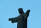
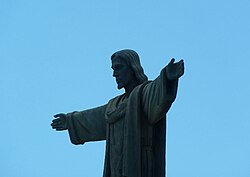
Christ the Redeemer statue - Puerto Plata
On the 739m (2,425ft)-high mountain Pico Isabel de Torres, the highest point of Puerto Plata, there is a botanical garden and a replica of Christ the Redeemer, the famous statue in Rio de Janeiro; though the statue is of a smaller size, the mountain itself is taller than that of Rio. The roads leading up the mountain are subject to large amounts of rain and are occasionally impassable.
The recorded history of the Dominican Republic began in 1492 when the Genoa-born navigator Christopher Columbus, working for the Crown of Castile, happened upon a large island in the region of the western Atlantic Ocean that later came to be known as the Caribbean. It was inhabited by the Taíno, an Arawakan people, who called the eastern part of the island Quisqueya (Kiskeya), meaning "mother of all lands." Columbus promptly claimed the island for the Spanish Crown, naming it La Isla Española, later Latinized to Hispaniola. After 25 years of Spanish occupation, the Taíno population in the Spanish-dominated parts of the island drastically decreased through genocide. With fewer than 50,000 remaining, the survivors intermixed with Spaniards, Africans, and others, forming the present-day tripartite Dominican population. What would become the Dominican Republic was the Spanish Captaincy General of Santo Domingo until 1821, except for a time as a French colony from 1795 to 1809. It was then part of a unified Hispaniola with Haiti from 1822 until 1844. In 1844, Dominican independence was proclaimed and the republic, which was often known as Santo Domingo until the early 20th century, maintained its independence except for a short Spanish occupation from 1861 to 1865 and occupation by the United States from 1916 to 1924.
Gregorio Luperón International Airport, also known as Puerto Plata Airport, is located in Puerto Plata, Dominican Republic. It is the Dominican Republic's fourth busiest airport by passenger traffic and aircraft movements, after Punta Cana, Santo Domingo and Santiago de los Caballeros. The airport is named after General Gregorio Luperón, a Dominican military and state leader. Capable of handling planes of all sizes, Puerto Plata Airport has benefited from being in an area with many beaches, which are popular among charter airline passengers. The popularity of the city where it is located has also drawn a number of regularly scheduled passenger airlines over the years.
Compañía Dominicana de Aviación, usually shortened to Dominicana, was an airline based in the Dominican Republic and served as the flag carrier for the country.
The culture of the Dominican Republic is a diverse mixture of different influences from around the world. The Dominican people and their customs have origins consisting predominantly in a European cultural basis, with native Taíno and African influences.
The Dominican Republic is divided into thirty-one provincias, while the national capital, Santo Domingo, is contained within its own Distrito Nacional.
Monte Plata is an eastern province of the Dominican Republic, and also the name of its capital city. It was split from San Cristóbal in 1992.
Puerto Plata ; is a province in northern Dominican Republic. It is divided into 9 municipalities, 12 municipal districts and its capital is the resort city of the same name. Neighboring provinces clockwise: Monte Cristi to the southwest, Valverde and Santiago to the south and Espailat to the east, along with the Septentrional mountain range to the north, and has a coastline with the Atlantic Ocean. The area has become an increasingly popular tourist attraction since the late 1990s mainly due to its fine beaches.
Santiago de los Caballeros, often shortened to Santiago, is the second-largest city in the Dominican Republic and the fourth-largest city in the Caribbean by population. It is the capital of Santiago Province and the largest major metropolis in the Cibao region of the country. Santiago is the largest Caribbean city that is not a capital city, and it is also the largest non-coastal metropolis in the Caribbean islands. The city has a total population of 771,748 inhabitants (2022). Santiago is located approximately 155 km (96 mi) northwest of the capital Santo Domingo with an average altitude of 178 m (584 ft).
Aero Caribbean was an airline based in Vedado, Plaza de la Revolución, Havana, Cuba. It operated scheduled domestic passenger services to domestic destinations and international services, and charter flights mainly within the Caribbean and South America. Its main base was at José Martí International Airport, Havana.
La Romana is a municipality and capital of the southeastern province of La Romana, opposite Catalina Island. It is one of the 10 largest cities in the Dominican Republic with a population estimated in 2010 at 130,426 within the city limits, of whom 127,623 are urban and 2,803 are rural. The name Romana comes from the word "Bomana", a name given by Indians to what is known today as Romana River.
Gregorio Luperón was a Dominican revolutionary, military general, businessman, liberal politician, freemason, and Statesman who was one of the leaders in the Dominican Restoration War. Luperón was an active member of the Triunvirato of 1866, becoming the President of the Provincial Government in San Felipe de Puerto Plata, and after the successful coup against Cesareo Guillermo, he became the 28th President of the Dominican Republic.
The Dominican Restoration War or the Dominican War of Restoration was a guerrilla war between 1863 and 1865 in the Dominican Republic between nationalists and Spain, the latter of which had recolonized the country 17 years after its independence. The war resulted in the restoration of Dominican sovereignty, the withdrawal of Spanish forces, the separation of the Captaincy General of Santo Domingo from Spain, and the establishment of a second republic in the Dominican Republic.
Boca de Yuma is a town of La Altagracia province in the eastern region of Dominican Republic. It is situated west of the mouth of the Yuma River, near the Caribbean Sea. The word Yuma is an indigenous Taíno name.
Sosúa is a beach town in the Puerto Plata province of the Dominican Republic approximately 4 miles (6.4 km) from the Gregorio Luperón International Airport in San Felipe de Puerto Plata.
The Reintegration of Santo Domingo was a brief period of Spanish reintegration of the Dominican Republic. In 1861, Dominican general Pedro Santana suggested retaking control of the Dominican Republic to Queen Isabella II of Spain, after a period of 17 years of Dominican sovereignty. The newly independent Dominican Republic was recovering economically from the recently ended Dominican War of Independence (1844–1856), when the Dominican Republic had won its independence against Haiti. The Spanish Crown and authorities, which scorned and rejected the peace treaties signed after the dismantling of some of its colonies in the Spanish West Indies some 50 years prior, welcomed his proposal and set to reestablish the Capitancy.
El Port of Puerto Plata is found in San Felipe de Puerto Plata, in Dominican Republic. This is the main port on the north coast and is currently used for cargo operations. In December 2021, the new Taino Bay tourist and cargo terminal was inaugurated.
Ulises Hilarión Heureaux Leibert nicknamed Lilís, was president of the Dominican Republic from September 1, 1882 to September 1, 1884, from January 6, 1887 to February 27, 1889 and again from April 30, 1889 maintaining power between his terms until his assassination by Ramón Cáceres.
The Fortaleza San Felipe is a historic Spanish fortress located in the north of the Dominican Republic in the province of Puerto Plata. Also known as El Morro de San Felipe, it was used to protect the City of Puerto Plata from foreign invaders, pirates, and privateers. It is located on a hill at the Puntilla del Malecón, overlooking the entrance to the city's seaport.
Tourism in the Dominican Republic is an important sector of the country's economy. More than 10 million tourists visited the Dominican Republic in 2023, making it the most popular tourist destination in the Caribbean and putting it in the top 5 overall in the Americas. The industry accounts for 11.6% of the nation's GDP and is a particularly important source of revenue in coastal areas of the country. The nation's tropical climate, white sand beaches, diverse mountainous landscape and colonial history attracts visitors from around the world. In 2022, the nation's tourism was named the best-performing nation post-pandemic with over 5% visitors more in comparison to pre-pandemic levels in 2019.
Gaspar Polanco Borbón was a Dominican Republic military general and politician. He has been one of the most notable military figures in the history of the Dominican Republic and served as the country's president.
↑ National Bureau of Meteorology (ONAMET). "Pronóstico Turístico Mensual" (in Spanish). Santo Domingo. Archived from the original on September 28, 2011. Retrieved June 4, 2011.
↑ Antonio Cocco Quezada. "TURISMO Y CLIMATOLOGIA". Tourism & Climatology (in Spanish). ACQ & Asociados. Archived from the original on September 12, 2011. Retrieved June 4, 2011.
This page is based on this Wikipedia article Text is available under the CC BY-SA 4.0 license; additional terms may apply. Images, videos and audio are available under their respective licenses.