New Delhi is the capital of India and a part of the National Capital Territory of Delhi (NCT). New Delhi is the seat of all three branches of the Government of India, hosting the Rashtrapati Bhavan, Sansad Bhavan, and the Supreme Court. New Delhi is a municipality within the NCT, administered by the NDMC, which covers mostly Lutyens' Delhi and a few adjacent areas. The municipal area is part of a larger administrative district, the New Delhi district.

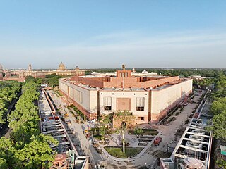
Nehru Place is a large commercial center in Delhi, India. Although its importance as a financial center has declined in recent years, Nehru Place is still a prominent commercial area in South Delhi and houses the headquarters of several Indian firms and rivals with other financial centers in the metropolis like Connaught Place, Bhikaji Cama Place and Rajendra Place.

Mehrauli is a neighbourhood in South Delhi, Delhi, India. It represents a constituency in the legislative assembly of Delhi. The area is close to Gurugram and next to Vasant Kunj.

Deer Park also known as Aditya Nath Jha Deer Park, is a natural park in Delhi located in the subdivision of Hauz Khas in South Delhi. It was named after famous social worker Aditya Nath Jha. This place is popular for walking, jogging and weekend outings. Deer Park comprises many subsections such as Duck Park, Picnic Spots Rabbit Enclosures etc. The park is accessible from Safdarjung Enclave and Green Park, Hauz Khas Village. It is also connected to District Park thus making it approachable from R K Puram near the courts side of the Delhi Lawn Tennis Association.

Lodhi Road in New Delhi, India, is named after the Lodhi Gardens located on it. Two Mughal mausoleums, Humayun's Tomb and Safdarjung's Tomb, lie at the eastern and western ends of the road respectively. A number of cultural, educational, and international institutions line the road. The Jor Bagh metro station lies under Aurobindo Marg near its intersection with Lodhi Road. Also located near it are Lodhi colony and Lodhi Estate built during British Raj in 1940s, and Lodhi Road Institutional Area.
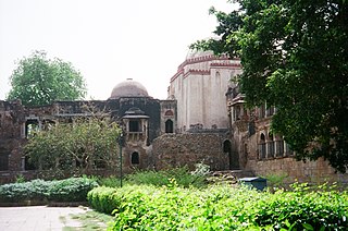
Hauz Khas Complex in Hauz Khas, South Delhi houses a water tank, an Islamic seminary, a mosque, a tomb and pavilions built around an urbanized village with medieval history traced to the 13th century of Delhi Sultanate reign. It was part of Siri, the second medieval city of India of the Delhi Sultanate of Alauddin Khalji Dynasty (1296–1316). The etymology of the name Hauz Khas in Persian is derived from the words ‘Hauz’: "water tank" and ‘Khas’:"royal"- the "Royal tank". The large water tank or reservoir was first built by Allauddin Khilji to supply water to the inhabitants of Siri. The tank was de–silted during the reign of Firuz Shah Tughlaq (1351–88). Several buildings and tombs were built overlooking the water tank or lake. Firuz Shah's tomb pivots the L–shaped building complex which overlooks the tank.

Safdarjung Airport is an airport in New Delhi, India, in the neighbourhood of the same name. Established during the British Raj as Willingdon Airfield, it started operations as an aerodrome in 1929, when it was India's second airport after the Juhu Aerodrome in Mumbai. It was used extensively during the Second World War as it was part of the South Atlantic air ferry route, and later during Indo-Pakistani War of 1947. Once situated on the edge of Lutyens' Delhi, today, it has the entire city of New Delhi around it. It remained the city's main airport until 1962, when operations shifted to Palam Airport completely by the late 1960s, as it could not support the new bigger aircraft such as jet aircraft.

South Delhi is an administrative district of the National Capital Territory of Delhi in India with its headquarters in Saket. Administratively, the district is divided into three subdivisions, Saket, Hauz Khas, and Mehrauli. It is bounded by the Yamuna River to the east, the districts of New Delhi to the north, Faridabad District of Haryana state to the southeast, Gurgaon District of Haryana to the southwest, and South West Delhi to the west.
IIT Delhi, officially Indian Institute of Technology Delhi, is a public institute of technology located in New Delhi, India. It is one of the 23 Indian Institutes of Technology created to be Centres of Excellence for India's training, research and development in science, engineering and technology. It is ranked among the most prestigious academic institutions in India.
Sri Aurobindo Marg or Aurobindo Marg, is an important South Delhi north-south arterial road connecting historic Safdarjung's Tomb to Qutab Minar. The road is named for Sri Aurobindo Ghosh; the Delhi campus of Sri Aurobindo Ashram is located on the road. The road was originally known as Mehrauli Road.
Malviya Nagar is a residential locality in South Delhi with property prices over 17,000 per sqft. Situated between Saket and Hauz Khas and close to IIT Delhi, its namesake is the freedom fighter Madan Mohan Malviya.
Yusuf Sarai is a locality in South Delhi. It lies on the Sri Aurobindo Marg close to AIIMS, New Delhi, and accommodates both residential as well as market places. It is named after historic Yusuf Sarai, one of many sarais which were built in area during and Delhi Sultanate period, including, Katwaria Sarai, Lado Sarai, Sheikh Sarai and Kallu Sarai.
Hauz Khas is a neighborhood in South Delhi, its heart being the historic Hauz Khas Complex. Well known in medieval times, the Hauz Khas village has amazing buildings built around the reservoir. There are remnants of Islamic architecture roughly colored by splotches of urban culture. It is centrally located and offers both rural Hauz Khas Village and urban Hauz Khas Enclave, Market environments. Hauz Khas is surrounded by Green Park, SDA to the west, Gulmohar Park towards the north, Sarvapriya Vihar towards the south and Asiad Village and Siri Fort to the east.

Green Park is an upscale affluent neighborhood in South Delhi, India. The locality is divided into two parts i.e. Main and Extension. The neighbourhood registered a 4.4% growth in residential sales and was featured alongside Greater Kailash, Defence Colony, Vasant Vihar and Anand Niketan in the 2019 edition of Knight Frank 's quarterly report on prime luxury residential properties in various megacities around the globe. Property rates have always been high in this colony due to the numerous facilities available. Builder floors and independent villas cost anywhere between INR 6–70 crores in this colony. Rental rates are also very high due to which this residential area is among the most expensive pin codes of New Delhi.
Gulmohar Park is a neighbourhood in South Delhi. This park lies between Hauz Khas and Gautam Nagar and is named after the red-flowered Gulmohar trees growing inside. The nearby residential colony is known as Gulmohar Park Journalists' Colony or simply Gulmohar Park for short, and was established by a group of journalists in the 1970s and is today home to business people, senior lawyers and cine star Amitabh Bachchan's Delhi residence.
Gulmohar Enclave is a posh neighborhood in South Delhi. It is adjacent to Gulmohar Park. It is a colony of 300 apartments and was constructed in 1983 by the Delhi Development Authority. It is now owned by the residents.

The Hauz Khas metro station is an interchange station between the Yellow Line and the Magenta Line of the Delhi Metro. It serves Hauz Khas Enclave, Sarvapriya Vihar, Vijay Mandal Enclave, RBI colony, Mayfair Gardens and the IIT Delhi. The entrance to the station is located on Outer Ring Road, to the east of Aurobindo Marg and to the west of Khelgaon Marg.
The Architecture of Delhi dates back more than a thousand years. As the capital of several great empires of India, including Rajput kingdom, Delhi Sultanate, Mughal Empire, and British Raj, the city of Delhi has been a centre for art and architecture.


